The route=road documentation doesn’t strictly discount streets, but it does recommend against it:
Most urban streets and minor roads which are identified only by a name=* tag do not belong to a relation.
One of the possible outcomes of this discussion might be to clarify when a route=road relation is appropriate versus whatever we decide on for streets.
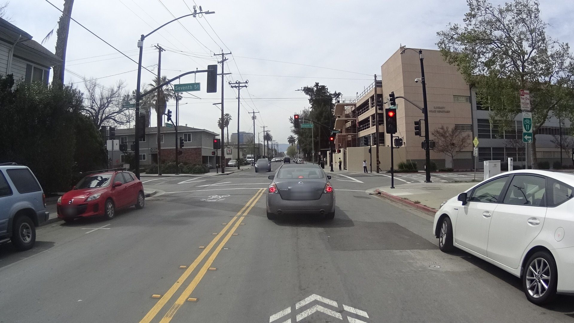
Maybe an example would help. My city has a small network of marked cycling routes, of which Bike Route 11 is the first and longest. It traverses a number of streets known by names and numbers such as Oakland, 7th, 17th, and Monterey. Bike Route 11 is a route in the sense of being designated as a route, marked by wayfinding signs and reassurance markers, and suggested on a map as an intentionally maintained corridor for traveling north and south through the city. It is not strictly the kind of route that a routing engine would output, also known as an itinerary, which might follow busier or quieter streets between the same endpoints, depending on the user’s preferences.
The reassurance markers for Bike Route 11 have a distinctive design that conveys not only the route number but also the route network, which in this case is tagged cycle_network=US:CA:SJ:

Here’s that same green and white sign with an arrow letting you know that the route departs from San Salvador Street to follow 7th Street. Streets have signs too, but it’s a different kind of sign and for a different purpose. In English-speaking cities, numbered streets are referred to by ordinal numbers like 7th instead of cardinal numbers like 7, which helps to prevent confusion with numbered routes.
Every aspect of a cycling route mimics a highway route, because most people are already familiar with the latter. Here’s an intersection in the same city where State Route 130 departs from Alum Rock Avenue to follow Mount Hamilton Road up the mountain to an astronomical observatory. This winding, picturesque route is followed by both motorists and cyclists alike. A sign just up ahead indicates that another route, the Juan Bautista de Anza National Historic Trail, makes the same right turn.
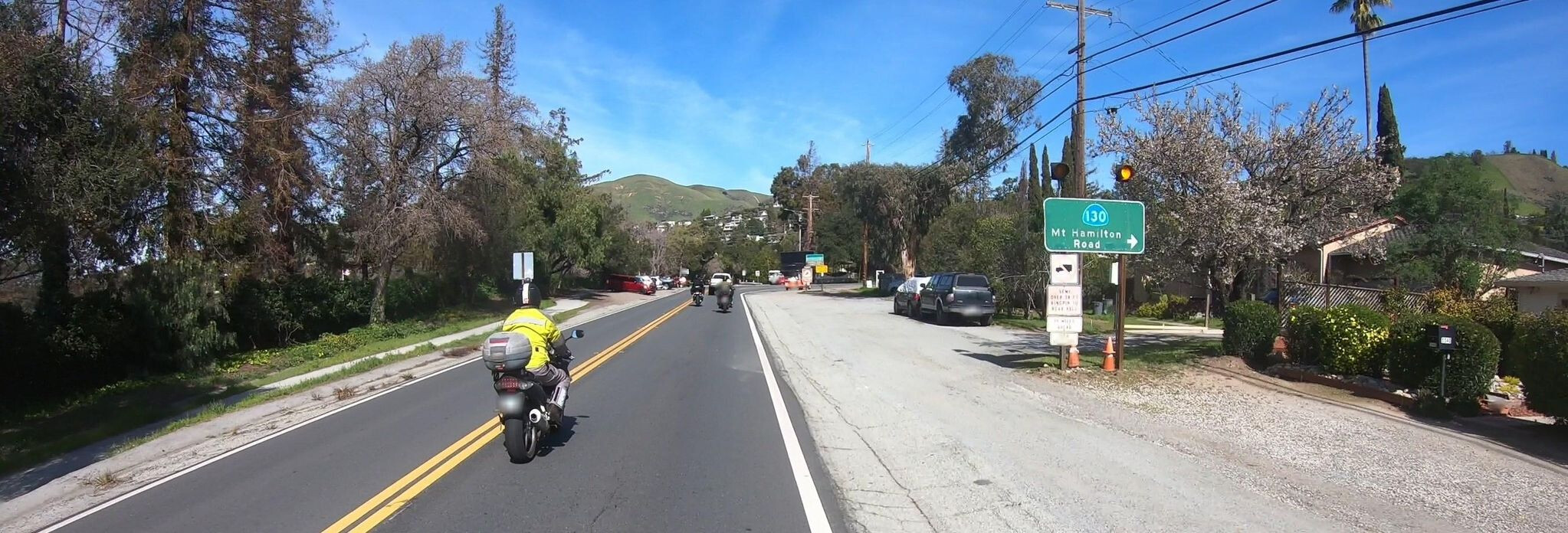
What I’ve shown you so far is the norm for routes of both kinds, not the exception. The only unusual thing is that the last sign comes with flashers because motorists often miss the right turn when trying to follow SR 130. An ordinary motorist intentionally follows a route because they can count on strategically placed signs to lead them to a destination – in this case, the observatory. Some routing engines are now capable of responding to this user need by trying to stay on the route (or trying to get off of it) while satisfying other constraints like time or distance. Though no less wordy, the instructions align with the user’s high-level understanding of where they’re going, simplifying the navigation experience.
“Road” or “street” refers to the physical infrastructure, or more broadly the environment around it. “Route” is an abstract concept that can sometimes be conflated with the physical infrastructure for convenience. You are accustomed to that convenience and I wouldn’t blame you for it. But I assert once again that the situation in Western Australia is much closer to the situation in California than to the situation in Estonia, if for no other reason than that Australia’s road signs and route designations were largely modeled after those of the U.S. rather than those of Europe.
These are very good points. As far as I know, neither Australia nor the U.S. even has a comprehensive nationwide inventory of all local streets, let alone a numbering scheme for them. But in these countries, highway route numbers and route relations are an essential element of transportation maps and turn-by-turn directions. Every router, every navigation application, and most maps based on OSM satisfy this need by presenting the route number to the user in some fashion.
Like most other keys, ref is generally intended for information that is verifiable on the ground. However, some route numbers aren’t signposted in a manner that the general public can use to find their way, so we tag them with unsigned_ref to avoid confusion. If this is always the case with every route in a certain country, maybe you could justify using ref on the basis that the lack of signage is a “national default”. ![]()
Or you could avoid making relations out of them. In the U.S., the Pennsylvania Department of Transportation systematically assigns road inventory numbers that only appear on very small signage, so we tag them on the individual ways as ref:penndot and don’t bother with relations. Some Wikipedians don’t like this very much, but that’s what the Overpass–GeoJSON–Commons approach is for.
Others in this thread have expressed an opinion that no relation should be used to represent a street. So far, I’ve avoided taking a hard stance on that, only because I think a ban on such relations would inevitably lead to Wikipedians tagging them as the next available thing, routes, to appease Wikimedia Maps without going through the trouble of exporting GeoJSON to Wikimedia Commons. Now I wonder if I should just side with them to avoid the trouble of explaining the concept of a route in increasing detail.
Yes, I have presented evidence that I believe shows Estonia to be an outlier. The 28 relations in Fremantle do not weaken this argument in the slightest. But I would be happy to generate some hard numbers to back your assertion that this is a significant global phenomenon, if you can tell me what to look for.
As the song goes, one of these things is not like the others. The bug was that eight roads routes overlapped on a single road, but I and other developers had incorrectly assumed that six was the most that would ever occur in the wild. The fix is to increase the maximum number of concurrencies to look for. This has nothing to do with whether Central Avenue is also represented by a relation. I pointed it out only to answer @osmuser63783 with a bit of good humor.