Steve Coast's proposal for OSMF strategic plan

Mobile equipments are more and more used for editing and for navigation with vehicules, hiking and velo trips, shopping, etc. In development countries, the phones are for many the main access to internet. There is a potentiel for OSM to better integrate these equipments in the edition / feedback loop.

Geolocated images could contribute to a provide more infos about a road but also be used for more feedback. A hiker or a cyclist could easily communicate the condition, the difficulty or the non existence of the trail. Could it be also possible for navigation by car? Images could be in a Street View layer. Combination of Images + Notes offers also a great potential but might need more thinking how to integrate. The same with our corporate partners that have valuable driving information. If shared, this would be a great info to add in the feedback loop.

This would help OSM map users to contribute more dynamically and assure that the map being a very reliable source .

+1 to map notes being turned on by default. That seems like a simple thing that could be done right now to encourage more contributions and QA editing. I also like the idea of social and map quality features being built into the website. It’s kind of ridiculous that despite the main thing behind OpenStreetMap is supposedly “the community” but then all or most of the community building and supporting things are mostly outsourced to other websites.

While I’m aware that there’s the forums and the wiki, I’m more talking of something alone the lines of a group editing feature and tracking of community based tasks and/or mapping progress. Sure those things can be done on the forums/wiki, but it’s just clunky and involves way to much work on the backend. As an example I privately keep track of how many of objects of a certain type are or still need to be mapped in my local area and update it on a regular basis. It’s hard or almost impossible to have a running task to do any sort of “map X amount of features until they are at 100% completion” though. Let alone to do any kind intermittent quality assurance on the objects that have already been mapped or get people from the local area involved in the project. At least outside of giving a lecture to my local college GIS department or whatever. It would be cool if there was just a URL on the main site for my county that I provide people with where all that be along with other community building features.

Not to mention some sort of badge/gamification system to encourage people from the local community to contribute. Yeah, I’m aware of the drawbacks, but I think it can be done in a way that accounts for them by having a minor amount of oversight and moderation involved. I don’t necessarily support full badge/gamification for the whole site, but I think it could be done well as part of a “community” feature where people from the local area compete with each other for temporary badges that only last for the specific project or timeframe and are controlled by a team leader or moderator. At least that’s how I imagine it.

I agree with that, but (as all the discussion in all the recent threads has shown) we’re really not short of ideas - we’re short of ways to implement them. Historically OSMF has been relatively hands-off - I can’t think of an example where they’ve said to the OSM Carto developers “you must show XYZ feature” for example. Going back further to the early years of OSM, Steve’s approach was far more direct - and there were issues with working groups as a result. People have stood for the OSMF board with more proposals to be more “hands-on” in recent years, and they haven’t been elected.

Whilst I’m absolutely sure that vector tiles would allow more flexibility on the client as to what is displayed, I’m less convinced that they will solve every single problem that gets raised in threads like this. Would I be able to take an existing hosted set of vector tiles (say for cycle.travel or OSM Americana) and show some key the creators of those styles hadn’t even thought about? Probably not. If I’m interested in Steve’s “feature:verified_2023” or similar and update something in OSM will my map looking at some vector tiles update immediately? Also probably not. However, let’s not let “perfect” be the enemy of “good” here.

The relevant bit of the OSMF strategic plan is here. That hasn’t been fleshed-out yet, but “development platform for vector tiles by volunteers” is (in my view rightly) at the top of the list.

4 Likes

I don’t think this is as big an issue that people imply. Rather than trying to get it all in the vector tiles, put the major stuff in the vector tiles and allow the website user to pull in more data (e.g. via overpass) as they choose (at revelant zoom levels). Sure it would be overlay data and not fully integrate with the style, buts it’s a lot better than today where you need to know about sites beyond OSM.org.

Indeed - the design of vector tile schema obviously impacts how close you can get towards solving “every single problem”. There are plenty of decisions to take along the way: how closely you cleave to the original OSM tags (vs rewriting, say, access-implying tags into something sane); what you drop at lower zoom levels; how you map relations onto vector tile features; whether you go up to z15 to get more headroom for some of the more detailed tags and intricate geometries; and so on.

But it’s entirely feasible to see a situation where we get 80% of the way to solving the major pain points. I think it’s reasonably obvious how we get there (it basically involves paying someone to work on the JS side of things on osm.org, someone else to work on the database, and these two people working together on the schema and some proof-of-concept cartography). If it hasn’t been solved by the end of the summer when I’ve finished the c.t Android app I shall start rattling some cages. :wink:

5 Likes

Sounds reasonable to me. We could even put such Debug map style as default for logged-in users (perhaps allowing them to change the default in preferences to some other map style).

But it is not trivial to create such Debug map tile server in the first place (much harder than say “bicycle map” style - as fetching in comparing when something was last modified is harder then just looking up the tags)

I’m going to regret this.

For starters (this bit goes for the board strategy too), any strategy discussion should start off with the goals we want to achieve through the strategy (which is literally "how we want to achieve the goals). What these are supposed to be is quite murky both in the case of Steves and the boards proposals.

Then really folks, it doesn’t make sense to start arguing about technical implementation details (even though I love to do that too), a strategy should be relative high level and implementation independent.

Random example of what would be reasonable is say

  • Goal: create the most complete map of the world
  • Strategy: attract dedicated hobbyists from around the globe with as diverse backgrounds as possible
  • Strategy: increase the productivity of existing contributors

Possible implementations of such strategies could be improving the experience for non-contributors on the website, better tooling for existing contributors and many other things that are sure to cause long discussion threads.

That out of the way: nothing in Steves list of items that he would like, outside of the token nod to diversity, is new. What is new is that large parts of the audience haven’t heard these ideas before.

Steves election platform in 2014 was literally elect me and two buddies to a three person board. An idea he has resurfaced now. That making the board smaller doesn’t jive particularly well with his suggestions to make the board even more operational and more representative is obvious.

Yes the OSMF is not without its structural issues, but throwing an organisational hand-grenade is going to stop the on-going working through the back log and addressing at least the urgent problems, and not do anything positive.

As to addresses see Simon Poole: "I'm too lazy to dig out the before last and befor…" - En OSM Town | Mapstodon for OpenStreetMap

tl;dr version: we are already adding addresses. Could it perhaps move a bit faster? Maybe, but it is just asking the -same- people to add more, and there are limits to how well that scales.

PS: snarky observation:

  • addresses added during Steves reign: ~10’000’000
  • addresses added post Steve: ~130’000’000

And that even though the map was empty in 2012 compared to now.
10 Likes

Good observation. The OSMF Board typically relies on working groups to operationalize actions. I guess that except by DWG, all new working groups always have at least one board member.

I understand that there is a need to increase volunteers working behind the scenes (what today are working groups) to be able to make viable the actions.

To quickstart things, maybe be “hands-on” / “direct” tends to work faster. I supposed that as OSMF moved to as working group approach, the direct intervention of OSMF would have an impact of make working groups feel less autonomy, so be less efficient.

I’m not saying that is a bad idea be more direct or totally hands-off, just stating that these are different approaches and OSMF is too much at the top. But today, likely one win-win approach would be direct approaches like from Steve be not merely accepted by the board itself, but welcomed in the working groups that are the hands-on today. Or (what he might already be implicitly promoting) bring more people to working groups. People already like him, but several actions would need to be coded.

I’ve just created a proposal (and my willingness to volunteer to help with this, so I am not merely asking others to do it) on additional layers focused on existing country-level content. Here’s the link:

https://lists.openstreetmap.org/pipermail/osmf-talk/2023-May/008653.html

Not commented yet

  1. Data for Improving points of interest (and their specific address) would be a different topic. For example, look at spin offs of threads related to how OSM Noted could be used on OSMF-talk.
  2. Either direct or indirect proposals based on Steve ideas means adding features to parts of the main website interface, but at least part of it could be coded via Chrome extension / Firefox Extension much earlier than waiting all the process of being merged into the codebase of the website. After the browser extension boilerplate, mostly work to change the website interface became reduced to injecting JavaScript and some HTML, plus knowing how to find external services which have the data.

The two is more limited than be able to do a massive change on the website interface, but even in the most simple form, this could at least add new background imagery on the main site and quick links to, for example, Simon’s http://qa.poole.ch/ , so mappers which truly don’t know they exist could have a “enhanced” versions of website based on the “founder vision”, just would need to install browser plugin for it.

Hey Simon, the http://qa.poole.ch/ is quite nice. What about suggest being added as QA-layer on iD or as global-level layer on osmlab/editor-layer-index? I guess the red lines of your tool plus country-level layers which have names for roads could be a good pair for mappers :slightly_smiling_face:

It has been available via ELI for ~ a decade.

2 Likes

Humm…

Fact: I can confirm that was added, “world / QA No Address”, url: https://tile{switch:2,3}.poole.ch/noaddress/{zoom}/{x}/{y}.png is on GitHub - osmlab/editor-layer-index: A unified layer index for OSM editors. (which in theory would make it reusable by other editors)

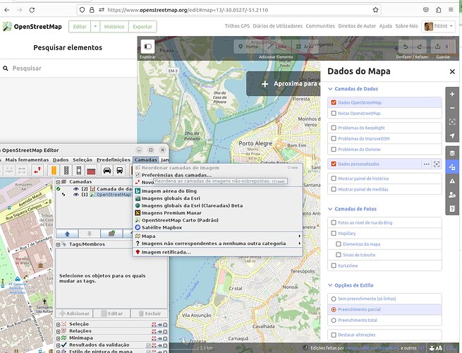
On the interfaces: I’m mostly only use iD, so maybe missing where is on JOSM, but on the print screen, there’s no obvious button to click and found this QA layer.

Yes, there links for other QA tools, but at least on iD (which is not as customizable as JOSM) the QA No Address (not sure if other layers) either are my error to find them or are not available on the interface.

Totally agree on this, though making vector tiles available by OSMF would be a strategy in order to allow more QA-maps on osm.org to reach the Goal of the “best” map. Maybe also some possibility, were the user can apply his own style to those vector tiles, so it’s available for more users.

Typical you first want get the road network done and only afterwards it makes sense to add addresses, so it’s nothing surprising :wink:

2 Likes

What benefits does a map have that only shows roads with maxspeed & surface present and no tiger:* tags, or only addresses with an addr:postcode and an addr:street tag that matches a nearby highway, compared to a well-crafted Overpass query that does the same thing?

IMO, a better use of osm.org website developments would be the integration or at least a clearer mention of the of the existing QA tools, like OSMCha, Osmose, Achavi, MapRoulette, Overpass (Turbo) or osm-revert, since mappers who engage in QA are often already familiar with at least one of these tools and can easily share their knowledge with newcomers through tutorials, dialogue and forum discussions.

5 Likes

For me the main difference is the target group. Everyone who is dedicated to QA somehow knows how to find the problematic areas. But it’s a small group of mappers. On the other site you can guide bigger groups of mappers to “hot-spots” where “OSM” things the map is in bad condition.
If a new guy hit OSM and browse around US, will he notice action is needed? I don’t think so. The map looks pretty complete road-wise. He don’t know about the real condition of US road-network and that OSM would actual need him to do some Tiger-cleanup/verification. This he will find out after reading a couple of Wiki-pages and then execute the overpass query. Do you think this is going to be happen? I don’t. The result is most likely, this potential mapper is satisfied with the map and simply use it.

It’s again far away from being a strategy, but I’m pretty sure if the map would show untouched Tiger-residentials in red or don’t show them at all, the result would be different.

And that’s again something regards strategy… The main point is how does OSM can advertise, input of new mappers is still necessary and what is most important for OSM. At least I see it as a huge problem, if huge areas have been traced >5 year ago and all the objects are still in V1. It’s pretty unlikely that data is still correct. But no user is aware of that. Our “competitor” would show the actual age of the map data. We are implying our maps are a couple of minutes old. If a user would get this information with some hint’s what to do, I’m pretty sure at least a couple of them would verify at least against more recent aerial images.

2 Likes

Similar ideas have been proposed before, but they don’t fit in Carto since Carto’s meant to be a “general-purpose map.” So you’ll have to build a whole new map with new rules, a new target audience, a new maintainer group and do all of it in vector which we currently don’t have at all on osm.org. That’s a lot of work for an idea that is currently only a brainstorm.

I recommend to everyone who thinks this idea has merit to go back to the drawing board and discuss the idea normally instead of recommending that the OSMF builds its strategy around it.

2 Likes

Example of OSM being updated directly

Ok, here one practical example of likely OpenStreetMap already be used by locals to add information which is not on internet at recent history at https://www.openstreetmap.org/user/Agostinho%20Soares/history#map=13/-9.2339/124.3838 . The language of the changeset is indonesian (automated translation: “This change was made because of the local government policy which has approved the name of the street”), but the roads are in Portuguese or mix of other local languages.

However, if we use the Simons overlay (link here http://qa.poole.ch/?zoom=16&lat=-9.21201&lon=124.34728&layers=TFFFB0 ) is clear that the person is missing some parts of the road that either are not named yet, or before the person added the names, it was split in more than one.

OpenStreetMap data already is used for routing and is more likely to be cared when already have better data than alternative. So, yes, I think we could improve a bit more this, or at least document (and encourage) locals adding names on the map (as long they’re are real ones). I don’t buy the idea that the mere fact a region don’t have official data about address we must forget use of OSM there, on the contrary, likely to be an advantage the nature of OpenStreetMap be open.

Nobody is talking about Carto or doing anything to Carto. Though Carto or back in the time Mapnik was the source of motivation for mappers to join. My area is still empty, that’s something small I can change. Nowadays there’s nothing like this. The map looks like kind of complete in first place. Isn’t it? But how to figure out, it’s up-to-date and complete by OSM point of view.
Somehow OSM needs to attract mappers collecting this data and that’s nothing going to happen by pointing out you can use some overpass-magic or tool xyz. Though there might be other ways to follow up on that strategy. I totally agree, this is nothing OSM(F) can achieve in month, but that’s why it’s called strategy. At some point we should be there, that OSM can attract new mappers and guide them, where their input is needed most.

I think that’s the main thing. Well, that and retention of current users. Personally, I’ve been mapping addresses locally based on ground surveying pretty consistently for like 6 years now and when push comes to shove I only added like 15% of the total addresses for my county. If even that. Someone recently added more by doing multiple imports from local government data, but even there I think it only got us up to like 40% if even. At the end of the day there just isn’t the local mappers in my area to map addresses to any degree that matters. Let alone POIs or to keep either one up to date.

You can implement fancy QA tools all day long, but the problem is there not being the people to do the mapping and an inability to retain users who will do it once they sign up. That’s why I like the idea of incentives to participate in mapping specific objects like badges and community tools being built into the main site, because those things help bring in mappers and give them a reason to continue contributing. I don’t think OpenStreetMap really needs yet another QA tool though. But then what exactly is being done to bring in new mappers and improve retention rates in absence of things like that though? :man_shrugging:

(I guess alternatively OpenStreetMap could be less hostile to imports or at least make them easier to do, but I don’t see that happening anytime soon. For good reason obviously, but large gaps in the data is just going to be the trade off when there’s no one to map individual addresses and there’s huge barriers to importing them to any degree that would matter)

I tend to subscribe to Tony Wilson’s naïve interpretation of praxis:

“Praxis is the idea that you do something because you want to do it, and after you’ve done it, you find out all the reasons why you did it.”

That’s how OSM works. You can have a four chapter, 80-action strategy and it won’t make anything happen. Or you can actually do the stuff you want to do, and then a year later you look back and wisely say “ah, yes, we’ve increased engagement [or addresses, or whatever] because we did that”.

One of the curiosities of OSM is that somehow we’ve managed to map the entire world at basically no cost and become the cornerstone of a billion-dollar industry, and yet no-one ever asks “what did they do right?”.

I’m not really interested in a massive strategy, a unified set of corporate goals, or a top-down “thou shalt map addresses”. It’s not how OSM has succeeded. It’s not how it will succeed. The implementation is and has always been the interesting bit. We mapped the world by mapping the world, not by telling people what to map or setting out a mapping strategy.

13 Likes

There’s a fine but important distinction between a strategy for the OSMF in its role of supporting OSM and trying to impose a strategy on OSM as a whole. I would argue that the former can make sense, and that Steves shopping list is an attempt to do the later.

9 Likes