That’s what I’ve been doing, and while it is intended for alpine environments I find it useful in other ones (sandstone rock in the US southwest etc). I personally think the bones of it can be adapted into a good system (or systems) but at the point where large parts of the text need to be ignored that IMO is an issue.
So that would be ignoring the trail and requirements section, and solely focusing on terrain.
In general it’s not clear which majority of the aspects are ignored, and which single one is being prioritized. In an area where sac_scale is actually used perhaps these would be clearer to guess, but honestly I would have no real idea what to expect from T2 terrain. It could be any combination of the following:
- a trail with a steady ascent
- trail that is uneven enough to require sure-footedness and good footwear
- a trail that has some “fall hazards”
- a trail that requires some navigation skills (but ignore that part)
IMO an unexposed trail with a smooth path shouldn’t be T2 just because it has a steady ascent. That’s kind of goofy IMO, and we can generally get elevation gain metrics etc from mapping clients these days anyways.
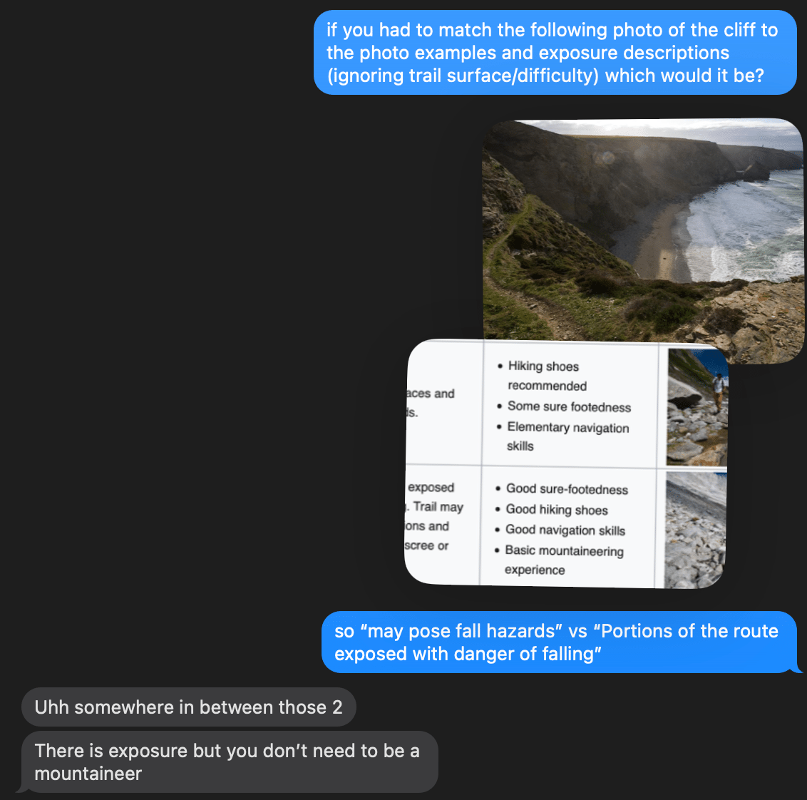
As someone who has never hiked on a sac rated trail, I’m not sure how they interpret the differences in exposure between T2 " may pose fall hazards", T3 “Portions of the route exposed with danger of falling”, T4 “Terrain already quite exposed”, T5 “Exposed”, and T6 “Severe exposure”.
T6 I would take to be knife-edge exposure, sheer drops with a path a foot wide at most. T5 and T4 I’m not sure of “quite exposed” I guess is more indirect, some ledges below you or something, or a steep slope you could possibly self-arrest on. T5 would be, in between the two? T3 feels more like “this trail may spook you but you’d have to kind of try to fall off of it”, T2 is you might trip and fall or lose your balance on a piece of talus. Can some European users comment on this take?
I would argue that “fall hazards” probably means that you could “take a fall” walking on an uneven surface (judging by the sample photo on the wiki and escalation that mentions falling and exposure later) and not exposure, and that trail would be T3 “Portions of the route exposed with danger of falling” despite looking like a nice smooth single track trail.
I feel CAI T & E do a better job than SAC T1 & T2 for less demanding trails.
That’s not going to be how non scramblers / mountaineers will think about ratings though. At the very least the wiki page should make this clear - that a T4 route can refer to either T4 levels of exposure or T4 levels of difficulty.
Having a smooth single track trail be marked T3 because it is near a cliff-edge is going to confuse people, there’s going to be an expectation of rougher terrain.
Comfort with those two don’t always go hand in hand. My partner enjoys unexposed T5 technique level terrain when hiking, but doesn’t enjoy fatally exposed T2 terrain. In my own shorthand adaptation of YDS and the risk movie rating criteria for class 5, I’m generally comfortable with 4 PG, 3 R, and 2 X when out hiking.
Imagining riding a bike on them seems like a reasonable way of approaching it, and I agree that using wheelchair=yes on highly developed trails that are accessible is a good thing to do! Smoothness only covers T1-2 terrain though using YDS it’s all variations of Class 1. I suppose anything beyond that level of smoothness would be assumed to be SAC T3, but this is getting into “read between the lines and ignore 95% of the description and values and then adapt it to a subsection of another key and figure that out yourself” which isn’t really a reasonable ask of the average person wanting to help rate a path.
Rollerblades are at least a wheeled mode of transportation made to be used on roads made for vehicles, I feel fine giving that one a pass. ![]()
