Perhaps highway=narrow_street could work.
3 Likes
highway=snickelway?
4 Likes
As an aside, not every footway has a sign. That idea might work in some places but not everywhere. For example, most of these alleyways are footways and don’t have signage.
2 Likes
Sadly none yet. Yet.
1 Like
Or highway=shutt
I don’t quite get it… we have width=* and maxwidth:physical=* which can be added to each highway=* and each data consumer can make a cut wherever he thinks is suitable minimum width. I don’t see a need in having additional highway-tags for it and how you want to define one minimum width?
For non-British readers here, British English has an absolutely bewildering set of dialect words for “narrow street or passage”.
But “highway=alleyway” is actually quite tempting because (a) it’s still the widely-understood “alley”, but distinct from the existing service=alley as per @julcnx’s point above, (b) alleyway is a genuine word, (c) it continues Andy Robinson’s original tradition of highway=somethingway.
2 Likes
The English wikipedia article on alleys is quite interesting and includes many different names used around the world. The things is that these terms are broad and seem to include pedestrian only alleys as well as wider alleys where there is space for standard width four wheeled automobiles. If a new tag is coined it seems the goal would be a special case specifically for narrow alleys where motor vehicles are allowed but only narrow vehicles can physically fit, correct? Wider alleys would still be highway=service + service=alley and pedestrian only alleys would still be highway=footway?
I think there are four types of alleys
- rear access to properties, a sort of shared service road. Tagged
service=alley. New York example - narrow streets, but still wide enough for cars, provides access to front of properties. Controversial. Tagged
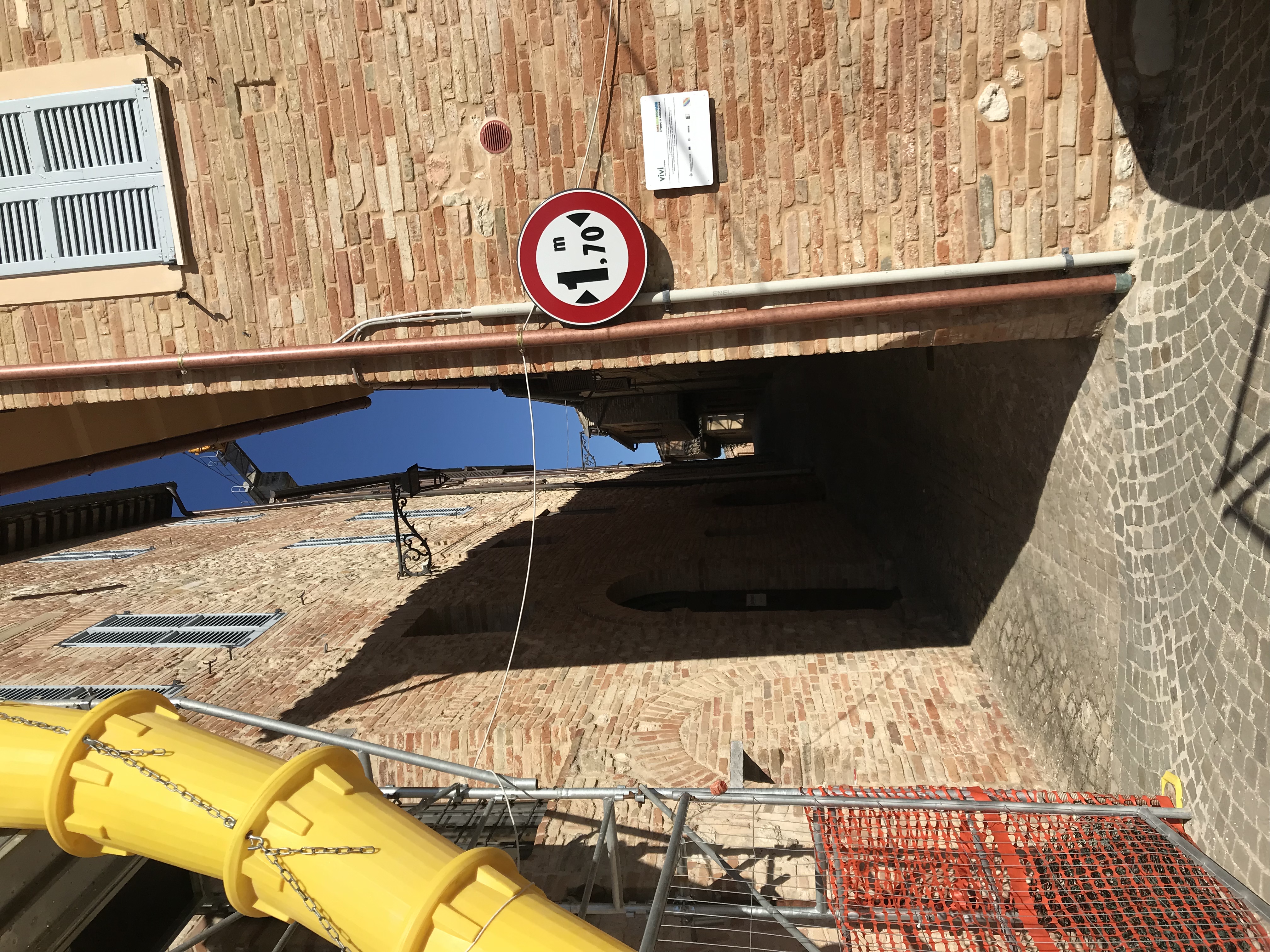
highway=service service=alleyor=residentialetc. withwidth=. Rome example - narrow streets, too narrow for cars, but legal for motorcycles etc. Tagged either
highway=service service=alley(Italy example) orhighway=path motorcycle=yes(Bangkok example) - footways and steps. Edinburgh example
I think the new tag, highway=alleyway or similar, would be for (2) and (3), correct? Leaving service=alley for (1), and leaving (4) alone.
Or would it just be for (3)?
2 Likes
This somehow confirms the validity of @ezekielf ’s suggestion, because the first sentence is:
The Snickelways of York , often misspelt Snickleways , are a collection of narrow streets and alleys in the city of York, England.
1 Like
Agree, that this might be somehow helpful, since they are also not really fit into the highway=service though it will not help at all with the width-issue.
There are 4 cases as far as I understand:
- Wide and comfortable local ways for most vehicles: that’s the typical highway=residential or, sometimes, highway=unclassified
- Narrow but wide enough for most vehicles
- So narrow that only certain rarer vehicles can pass
- So narrow that no vehicles can reasonably pass except with unusual skill, even if technically legal; those are usually mapped as highway=footway/path based on their main intended use (highway=path would be used in cases with two or more main intended uses, such as both pedestrian and motorcycle traffic)
On #3 we face cultural differences, as in some countries traffic is dominated by (smaller) motorcycles, and as a result have more narrow ways open to their traffic, and in some countries cars may be somewhat smaller than in others. In fact, these parameters can change within the same country or even within the same city, at least where I map. This is why I prefer to base my judgement of “narrow” on local planning documents.
In some places, many of these very narrow ways exist in dense urban areas, where major streets are typically classified by traffic function (often called arterials, collectors, etc., but the official names do vary between places). Over time highway=residential in OSM changed from being “a way surrounded by residences” to “a way providing access (as opposed to through traffic) within residential areas”, becoming nearly synonymous with “local way”. When local ways get exceptionally narrow, the effect is like continuing down the access/mobility scale towards less mobility and more access: they end up being avoided by those who know well the area while driving/riding around neighborhoods, unless one wants to get to/from a point within. The effect is similar to access=destination, without the legal requirement. To some, this difference is not worth a separate highway=* class as if it were a separate functional level. To others, it is different enough, as average speeds drop significantly and the chance of other issues (like getting blocked by someone else) increase significantly as well.
I think that defining highway=alley or highway=alleyway would resolve the issue with service=alley being originally intended for ways providing shared access to rear and side entrances only. Whether we should define another highway=* value for streets usable only by small motor vehicles (like very small cars, or motorcycles) is an open question to me. Maybe we could encourage data consumers to carefully parse other tags (lanes, width) combined highway=alley/alleyway and then map cases #2 and #3 with the same new highway=alley/alleyway.
2 Likes
Maybe you should first define this in a value. In the US a dual rear wheel truck has a width of 96" (~2.45m) and is still considered as “car” in terms of law on the other side you have the smaller cars mentioned already in this thread reaching below ~1.5m
That seems to me the only option given the diversity of cars. It doesn’t help anyone if we define everything which is less than 1.5m (for instance) is not a highway=service,residential,... and still I get stuck with my car, tricycle on a highway=service,residential,... which is only 1.6m wide.
1 Like
a new “narrow street” class would not prevent us from tagging the actual width as well. The limit would probably be higher than 1.5m, everything below 2m width is surely narrow, for example in Germany 2.5m is the maximum permissible width for cars, so everything below 2.7m is likely to be considered narrow (because you also need some space at the sides if you don’t want to scratch along the walls), and you still won’t get around curves with a 2.49m car in a 2.7m wide road, and pedestrians still would have to step into a doorway to let you pass
1 Like
Will one narrow street class be enough? In China there is a huge ‘unclassified’ network which will fall in your class of below 2.5m. So at least we would need ‘narrow_residetial’ and ‘narrow_unclassified’. If you define service class as well wider than 2.5m we would need as well a ‘narrow_service’.
And still to make actual use of it you would need to consider ‘width’. So where is the benefit in combining width and highway class?
Please focus on (3) only, as in developing countries, most minor roads would already fall under category (2). Therefore, the new highway=alleyway tag should be used only as a special case for narrow urban motorized pathways.
For category (2), we already have lanes=1 + oneway=no + width=* or access=destination, which serves the intended purpose.
The main point of this discussion is about category (3): ‘narrow roads that are too small for [most] cars.’
The width threshold doesn’t need to be universal, as it can vary significantly between countries like the US, Italy, or Japan. Each country could define its own minimum width for a typical 4-wheel vehicles.
For reference, OSRM:
- will not direct a vehicle along a road with a
width<2.2and anarrow=yestag - will impose a 0.5 speed penalty for any way with
width<=3, or any way withlanes<=1that does not haveoneway=yes.
With a lower threshold (e.g., 2m), the number of narrow ways should be significantly reduced. However, I’m also concerned that the new highway=alleyway tag could lead to further complications.
For instance, in Thailand, we have very narrow ways that are impassable for typical cars but wide enough for tuktuks (1.5m to 2m), while other narrow paths can only be used by motorcycles (1m to 1.5m).
This could suggest the need for an additional tag, like highway=motorcycleway, which might make sense for legally designated motorcycle pathways.
At least in China those ways are not legally designated for anyone. They serving a purpose (highway=residential or highway=unclassified) and are narrow ( width~1.5 ). Sometimes they come along with steel structures enforcing a maxwidth=* and a maxheight=*. But except those physical limits everyone is legally allowed to use those roads.
I can understand the benefit of having a highway=alleyway instead of using highway=service + service=alley, but I would strongly suggest to keep any physical limitation out of the road-classes. There are good reasons, why there are dedicated tags for all those physical limitations. Keep the highway class to represent the function/purpose of the road and leave the rest for those special tags.
1 Like
Approximately 90% of highway=path in Thailand are dirt paths less than 1 meter wide, primarily used for agriculture and forestry. With no legal restrictions and mostly used by motorcycles, should they be mapped as highway=track instead?
Are you fine with these narrow paths being rendered the same as a 5-meter-wide, two-lane residential road?
I understand the reasoning behind keeping the original classification (unclassified, residential), but routers and renderers need to adjust their navigation and display accordingly. Since not everyone will include the exact width tag, we need an alternative way to differentiate them. One idea could be to simply add alley=yes and/or narrow=yes which is already supported by OSMR.
1 Like
If that’s their main purpose, that should be highway=track with a width=0.9
That was my suspicion… Every renderer can use width=* and render narrow roads differently. If that’s your real “problem” you should approach the renderer to simply do so. No need to change anything on the data.
1 Like
In an ideal scenario, yes, but no renderers currently support width, and only one router does. Why? Dealing with numeric values complicates things and raises the issue of which threshold to use. Additionally, this is not how narrow agricultural tracks are mapped globally.
I generally oppose tagging for the sake of rendering, which is part of why the use of service=alley for narrow residential roads is controversial. However, we need a compromise to ensure maps are useful for both routing and rendering.
There are clearly two schools of thought here, each with strong principles, and finding a middle ground seems to be the best approach.
So, how should you tag a narrow way that’s clearly too tight for a motorcar, but where the exact width is unknown? The tag motorcar=no isn’t suitable, as it only indicates legal restrictions and not physical ones.