Did you notice that this row shows three pictures, did you read what the text besides says? I will not downvote your post. I just happen to observe such mapped: bare paths, no attributes. Past and present.
People need to be made aware of how little information they provide (the mappers) and how little information they receive (the consumers.) And that merits pole-position!
The routing treatment – I guess you appeal to this – was single-handedly composed by a mapper with lots of idiosyncrasies. Yet, I consider the rationale fine: The number of paths in the woods and above the tree line is orders of magnitudes larger than the number of so-called shared-use paths signed with blue rounds. Generally cycling there prohibited by law. Ergo: Most of what is mapped “path” here NOT open to cycling.
As to the blue signed designated ways: The cycleway base outnumbers the path base by a ratio of 5:4 in favour of cycleway in Austria. Not much of a margin. ID vs. JOSM? Maybe too easy. In a recent poll in this forum here, cycleway was preferred 7:1 over path to base such.
The wiki entry for highway=path, the subject of your post, suggests that highway=path is usually most appropriate for shared paths suitable for both pedestrians and cyclists.
Anywhere the wiki includes a traffic sign diagram, there should be a caption that clearly labels it as a traffic sign and indicates the jurisdiction(s) associated with the sign. We can’t assume everyone is even familiar with the sign system, let alone the specific sign. I’ve corresponded with more than one mapper from North America who didn’t even realize the blue discs are traffic signs. To someone who has never encountered Vienna Convention signs in person, they look like cute icons representing modes of transportation, with an arbitrary blue background. No wonder users reach for the tagging combination without regard for regional legal quirks.
Even so, highway=path is nuanced enough without turning the documentation into an eye-watering sign gallery like we have for maxweight=* or hazard=school_zone. If something inherently country-specific like a traffic sign is really so important for understanding when to use highway=path, then ideally we’d document it on country-specific pages, leaving the global page to focus on the meaning of the sign.
Like the wiki, JOSM’s Preset menu also optimizes for Vienna Convention countries using Vienna sign icons. It’s actually a pretty good idea to use a traffic sign as an icon if there’s a one-for-one correspondence between the sign being present and the preset being applicable. It saves users the trouble of deciphering yet another custom icon, such as the trapezoid that means “path” in iD. (It’s a path going off into the distance, not the side of a milestone.) But the traffic sign becomes counterproductive if the application also shows it to users who aren’t from the relevant countries.
Anywhere the wiki includes a traffic sign diagram, there should be a caption that clearly labels it as a traffic sign and indicates the jurisdiction(s) associated with the sign. We can’t assume everyone is even familiar with the sign system, let alone the specific sign. I’ve corresponded with more than one mapper from North America who didn’t even realize the blue discs are traffic signs. To someone who has never encountered Vienna Convention signs in person, they look like cute icons representing modes of transportation, with an arbitrary blue background.
most people live in countries who are party to the Vienna UN Convention on road traffic (about 6 billion), but you are right that we should not assume that the minorities who don’t will recognize these signs.
Yes, non-Vienna-influenced countries are technically in the minority, but not such a minority that laypeople necessarily even know they’re in the minority. (In case anyone is wondering, 46% of the global population live in the countries that aren’t parties to the Vienna Convention, and several signatories never ratified it.)
Even among Vienna Convention countries, either some signs are inconsistently implemented, or local communities have been ascribing extra meaning to the signs that doesn’t generalize across borders. At least that’s the impression I get from the half the discussions about highway=path, where some have said, “We don’t have this sign in my country,” or some have debated whether the same exact blue disc can refer to two subtly different situations. That’s why it’s important for any sign-to-tag recommendation to indicate a jurisdiction where possible.
I do not think that there are that many people living in the countries that are coloured dark green in this picture – File:Vienna Convention on Road Signs and Signals.svg - Wikimedia Commons – it seems recent, from looking at the changelog. Maybe though, lots of places just burrowed Vienna Convention signs without ratifying the statute?
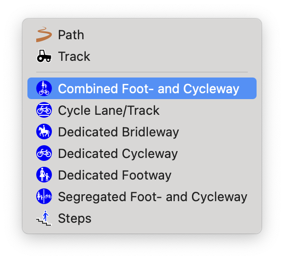
This looks a great handout for mappers. The only suggestion I find disputable: Tagging both bicycle=designated and informal=yes on the same?
Perhaps @geozeisig wanted to tell mappers and consumers of openstreetmap data, that a highway=path that also carried the foot=designated tag would at least also carry smoothness=intermediate (no less) or surface=paved (not ground, e.a.)? I’d say, such a heuristic probably in order for certain consumers, but not something that should be advertised on global scale.
It’s complicated. Yes, many countries have borrowed individual signs or concepts from the Vienna Convention without bothering to ratify the treaty. For example, Central America incorporated European prohibitory signs into their otherwise heavily U.S.-influenced traffic sign standards. And then the U.S. even briefly adapted some of those signs in its failed attempt to metricate traffic signs about 20 years ago. Conversely, Liberia acceded to the Vienna Convention, but in practice, virtually all the signs on its main highways conform to the MUTCD because of who funded the road projects.
Regardless, the specific signs at issue here aren’t even consistent among Vienna Convention countries, let alone the other half of the world. We make a big deal out of them because we care very deeply about non-motorized transport, but most of the world doesn’t regulate off-road paths enough to need signs like these.
FWIW I have no problem with sign logo’s that don’t exist where I live, if they have a clear meaning. If they illustrate a situation that exists here, fine, I’ll click on that if it’s a preset; if we don’t have that here, I’ll ignore the “alien” logo.
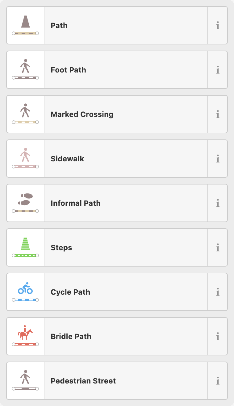
I think a good documentation should provide essential information as quick as possible. In this context, ordering the example table by occurrence makes perfect sense to me and would help to save readers time.
Yes, currently I get the impression that the three examples with traffic signs suggest that a way, if signposted, implies a highway=path, but this has no evidence in the OSM data.
Do we really want more simple highway=path without additional tags?
I would prefer good examples with good tagging and replacing the signs with pictures of paths with those signs.
Documentation should be concise, and it should be on topic. I take this as granted. So I repaired the broken (in markup) examples table (link above) and as a by-product left only three pictures in place:
How to do it correctly
How not to do it – Reasons spelled out in explanation
Urban planning
The link above the table left intact. After all, the linked page shows the mess we are in was already known back in 2008. Incidently, path quite early on was targeted by “extend and embrace” tactics – Key sac_scale e.g. widened it to include pathless mountaineering routes and scrambles (a.k.a. non-technical climbing.)
People who think these three pictures miss their favourite use please add additional ones to the “do it correctly” section – Or just mark this post with a thumbs-down, as you like it
I’ve been mapping in Indianapolis lately, where the internationally renowned, citywide Cultural Trail system imported some European sophistication, adding a dash of American flair:

