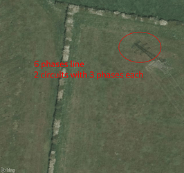
At the West Burton end, I’m not sure that you can. There’s no public access there; you can’t get within 600m of the power station. I’m not convinced that imagery will help here either; West Burton A closed a while back and I’m not sure if the imagery is post or pre that date. Even it it was up to date, I can’t see how you can map these values from imagery.
Hello
It certainly will. It shows 6 cables line splitting in two 3 cables line with confidence
These premises aren’t related to the EDF station but to National grid substation and are still in service as the substation also serves as an uplink for West Burton B gas power plant.
Imagery won’t tell you for physical properties but some information plate in place sometimes can.
Many lines are being reconductored in GB these years, some information about that may be found in place or during public meeting about the operation as well.
It doesn’t prevent to add the relation with available values this time and complete later when the information became available in accordance to our guidelines.
Sorry, that was probably a misunderstanding — your choice of words and some of the statements about OhMyGrid in your previous response gave the impression that you had a general problem with our open initiative, power mapping and some of the people involved.
To make some important point clear again:
- We discourage people to do data imports on multiple parts of our website like here: Map It!
 - OhMyGrid
 - Distribution lines is not something we are interested in. Please let’s not mix up things here again. Distribution data is very hard to verify and can only be mapped with large scale local collaborations. On the transmission side almost all the data I have seen is verifiable with satellite images and mapped with official OSM satellite imagery.
- Yes, I’m also part of OhMyGrid, that is an open initiative with some payed and some unpayed mappers, but our core mission is not to map but to empower others to map. The payed people focus on training others and develop tools for others to map the grid as announced here. We do this mainly to enable open science energy system studies in low-to-medium income countries by using it in combination with the open source framework PyPSA-Earth. Everyone is very welcome to join. Here the link to our public community chat: https://discord.gg/a5znpdFWfD
- On the security aspect. While mapping I have seen MUCH worse things mapped in OSM from a security point of view. The grid is a public good and public infrastructure and the data about it should also been considered a public good.
- In particular, the part of the proposal on line segments and the circuits will allow much better use of this data for studies of the expansions of the electrical grid in low-to-medium income countries. This proposal is therefor very much relevant for OpenStreetMap as also the International Energy Agency stating this as a key policy recommendation:
Improve data reliability and availability to better assess and manage risks for clean energy projects in emerging market and developing economies.
Key Recommendation - International Energy Agency: How to implement the COP28 energy goals
The primary aim of this proposal to enable mapping of power line topology, and I support this. The topology of power lines is verifiable, and for larger power lines this is increasingly possible with aerial imagery. Even if only used for larger lines, this data is still useful.
I also think this is sufficiently different from type=route that it deserves its own relation type.
Even ignoring the more complex uses, the relations are useful for grouping together long power lines, particularly when they change location. Data consumers are already using the existing relations for this, for example in this paper.
However, I am not keen on including the impedance numbers in this proposal, as they aren’t surveyable and the only reasonable way of populating these is via import. I think these should live outside OSM. The existence of these circuit relations will provide a stable identifier to link them to, if needed.
Hello all
Last week voting has lead to several relevant comments that we are still discussing. They show that some improvements are required in the proposal.
Thank you all for being involved in this process.
I prefer to close this first round of voting as of now and take care of comments. They are progressively added to the talk page: Proposal talk:Power circuits routing - OpenStreetMap Wiki
The RFC goes on here or on the Talk page and a new version will be submitted to the vote in a few days.
Best regards
As complementary inputs, please consider looking at
Both circuit relations share a common way except at the ends. This is perfectly visible from satellite view, and circuitery relation make sense here to disassemble physical connections that we can see from satellite view.
Tot add to this, in the Netherlands circuits have colours. In this case white (wit) and gray (grijs). Those colours are visible on all masts. The older system just has some paint on the mast, like this white paint meaning the north circuit is the white circuit. Newer masts have a sign in that colour with the first letter of that colour punched out and a sign telling the endpoints of the circuit.
So I think the on the ground problem is solved for the Netherlands.
Not really on the ground though ![]()
Dear all
The proposal has been updated since the end of first vote round.
- Physical properties has been removed
- Imports has been discouraged more clearly (despite not the point of this proposal)
- A few clarifications has been added
We can discuss it further, a second vote round is expected to begin shortly.
Best regards

