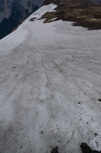
RfC Part 3: foot_scale=* (aims to describe global paths in a more helpful and informative scale than SAC)

This came to me while on a hike recently, and I think I’m ready to add in some images and then ask others to do so before proposing.

The bottom four values are still very focused on popular paths, the fifth is entering what can be common regionally, and the sixth is very specific. I don’t think that having values 5 and 6 somehow make it unusable for people only interested in the first 3-4 values, and it remains far less lopsided than SAC. I feel like adding another value on foot_scale makes a lot more sense than having essentially a one value scale for more technical scrambling.

Perhaps value six should be semi_technical_scrambling, but that’s a mouthful.

@Hungerburg can you tell me what countries in Europe print T5 and T6 on maps? I think having this be a rarely used value helps break it apart from more commonly occurring scrambling while still respecting some countries (and hence users) expectations for what constitutes a path.


Value 5: Simple Scrambling

More vertical terrain where hands are used to climb/scramble, but is simpler than technical climbing=*

foot_scale=simple_scrambling

Large obstacles or slopes that are steep enough they need to be “climbed” but are simpler than technical climbing=*in which use of safety equipment like a rope and harness are recommended. Hand and footholds should be fairly large, obvious, and sturdy. Your feet are off of level ground for more than a few moves and you need to move from handhold to handhold for an extended period of time.

Expectations:

  • Accessibility: You need to be able to pull up your body weight with upper body strength. While not considered “technical climbing” significant risk can be involved. Previous climbing or mountaineering experience is recommended though not necessary.
  • Focus: Loss of focus can have lead to serious or fatal consequences.
  • Footwear: Something a bit technical is recommended. You’ll generally want something more traditional with “structure” or a lightweight shoe that conforms to the foot for better feel and independent use of foot muscles for control.

Roughly equivalent to local scales:: Class 3 YDS, NFS Class 1 Trails, SAC T4-5, CAI EE, AWTGS 4-6?, PWS T3-R?, BMC Grade 1.

Value 6: Technical Scrambling

This overlap the lower end of technical climbing=* though often done without rope

foot_scale=technical_scrambling

There is often little to no sign of being a proper “path”, though it is a route that people have done before. Such terrain overlaps into UIAA I-II and YDS 5.5 difficulty.

Most countries don’t consider this to be a path - in the US formal (official & maintained) routes generally end at simple_scrambling, though it’s possible to find informal or social “use trails” that get into this terrain. Many countries in Europe will not print SAC T5 or T6 routes on maps. The United Kingdom, Austria, and ??? are places where such terrain is considered within the scope of a path.

Expectations:

  • Accessibility: You should be comfortable with technical climbing before attempting to free solo.
  • Focus: Loss of focus can have lead to serious or fatal consequences.
  • Footwear: Something specifically designed to be used for climbing is highly recommended.

Roughly equivalent to local scales:: Class 4 YDS, Bouldering VB, SAC T5-6, UAII 2, Austria “Alpine Route”, CAI EE, AWTGS 4-6?, PWS T3-R?, BMC Grade 2-3
I do not think any country in Europe shows T5 and T6 on printed maps, at least not knowingly of them being such :wink:

  1. Only in Switzerland there is an institution (SAC) to decide, what T? a route is
  2. SwissTopo only started some 20 years ago to include T4 (some, where there actually is a path on the ground?) after being lobbied by the SAC

Now, certainly, you will find routes on printed maps from several countries, that somebody somewhere might classify as T5 or T6. Eg. the route from Arzler Scharte to Rumer Spitze is the canonical example of a route containing UIAA II sections – That is what you will get told when asking local touring guides. It is in fact on a printed map, online here: Austrian Map In OSM-speak that should make it a T6. The cartographers might be aware of SAC™ scale, but I think for them, this is just a waymarked trail.

My fear is that a Value 6: Technical Scrambling level will almost always be a troll-tag when used in conjunction with highway=path and will encourage mappers to further stretch the range of highway=path. This would exacerbate the problem of naive data consumers that don’t differentiate on foot_scale=* rendering all “paths” alike even if some of them are technical climbing routes.

This isn’t to say that foot_scale=* is limited to highway=path. It is totally appropriate to use for other highway=* values. For example, highway=via_ferrata+foot_scale=technical_scrambling might be a very appropriate combination for some via ferrata segments. One or more new highway values could be created to cover scrambles, climbing route approaches/descents (which are often at this grade), and/or mountaineering routes. Such new highway values could be an appropriate base tags to use for ways with foot_scale=technical_scrambling.

2 Likes

Don’t worry, among the vast majority of data consumers, there’s nothing left to exacerbate : it’s de facto. One of the goal of these discussion is to devise a tag clear enough so that it can’t be ignored.

I don’t think that that is an achievable goal - just look at e.g. https://www.openstreetmap.org/way/556603351 up Mt Everest on the various map styles on osm.org and elsewhere.

1 Like

[quote=“yvecai, post:25, topic:109193”]
can’t be ignored
[/quote] or be shamed?

If contributors really want to map this as a highway=path, what can we do? At least, chances are a new tag will be used by the overzealous among us.

No need to fear a fresh expansion. Such “paths” are already in the data, up to UIAA VII. I tried to push a value in the highway key to separate those (at least the simple scrambles among them), the proposal failed to get enough approval. Maybe its easier to push a value to separate the others, something like highway=footway perhaps, in the sense, no-need-for-use-of-hands?

I’d also appreciate it such a new base would include no-path-finding-experience-by-looking-for-scatched-lichen-or-looking-20m-into-the-surroundings-to-find-the-continuation required.

1 Like

Things are moving on the styles at Osm.org, at least for the newest :
OpenStreetMap

1 Like

There, I’ve marked the “path” up on the Nepali side as private. I didn’t touch the Chinese side because I don’t know anything about it.

You won’t even make it to base camp without some preparation, so the risk is probably low that someone gets in trouble on Mount Everest after accidentally strolling up just because some phone app told them to.

A bigger problem might be paths lower down and in more accessible regions of the world being mapped as highway=path from the Strava heatmap without any information on difficulty, surface etc.

How would foot_scale deal with the following?

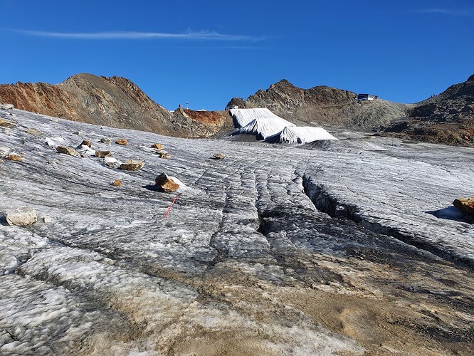
An easy glacier crossing. No snow, just ice, flat or almost flat, but you do need crampons or mini-crampons/spikes. No exposure. Is this surefooted_walking because you don’t need your hands? For comparison, in sac_scale this would be T4. So it’s difficult but not because it requires scrambling, and that doesn’t really fit into foot_scale. I guess this is the sort of scenario where double tagging both foot_scale and sac_scale would be useful? (Plus of course surface=ice)

4 Likes

I thought in a previous thread you mentioned a few that did - and then others that didn’t.

I personally consider such terrain to be more “routes” than “paths” in the US climbing sense of the word.

I’m not opposed to this, but it seems like there isn’t an appetite for a new semi-technical highway type. IMO it’s at least as valuable as via_ferrata, but that’s from a more global viewpoint than a euro-centric one.

There also doesn’t seem to be any limit on highway=path stopping at semi-technical terrain, so we’d also need to edit that heavily used tag which seems to be a surefire way to kill something on OSM.

One honest alternative is to stop at foot_scale=simple_scrambling and then mention that YDS 4, SAC T5-6 should just fall into climbing=*. Both of those values fall into what climbing=* already covers (UIAA I-II, YDS 5.0-5.5).

Ice climbing has it’s own rating systems of course, but Tag:highway=path - OpenStreetMap Wiki indicates that T6 is applicable to it, so is that actually an improper use of the tag?

This needs some refinement (and should be path_visibility) but was my initial attempt to not have 90%+ of trails just be excellent and put a higher bar on excellent vs just “well it’s adequate”.

https://community.openstreetmap.org/t/rfc-hiking-visibility-key-paired-with-hiking-technique-and-hiking-exposure-fall-risk-this-rounds-out-the-hiking-path-trinity/

It’d be surefooted. T4 according to the OSM wiki in regards to glaciers just means it’s snow free, which seems like it’d vary depending on time of year? I see no problem with YDS, SAC, BMC, FD, etc existing alongside foot_scale in areas where they’re used and think it can be of benefit especially on more challenging terrain. I originally just tossed everything in a single scramble rating as a “here be dragons” idea and figured people that really cared could sort it out using local scales vs forcing SAC on the world.

More appropriate would be the AI or WI 8 point scale, since that’s more specific, it’d be WI 1 if seasonal or AI 1 if there year round.

I think it’d pair well with expanding hazards beyond wheeled centric travel, for example there could be an ice traction needed hazard or something that’d show up next to a path (ideally) in a renderer similar to how some jurisditions do print maps and how mapping providers handle stairs.

Ideally should YDS 4 / SAC T5-6 semi-technical terrain be in highway=path?

  • Yes
  • No
0 voters

Given this is current practice, we’d need some solution - either a new highway type, moving such content into climbing=*, or something else.

1 Like

Is using demanding|difficult alpine hiking values for highway=path currently valid/proper in OSM?

  • Yes
  • No
  • Unsure
0 voters

Asserting that something either is or is not “technically/formally correct” in OSM is nearly impossible. The closest we can get is to say that there is or is not a general consensus about how said thing should be mapped. In this case we do not seem to have consensus. Many mappers feel that YDS 4 / SAC T5-6 semi-technial terrrain should not be mapped as as highway=path (including me), but many others feel strongly that it should be.

3 Likes

I’m going off of the wiki for simplicities sake. If someone tried applying sac_scale to a major highway or tagged a mountain stream as a convenience store it’d be considered incorrect

highway=path lists demanding|difficult alpine hiking as valid values, sac_scale says it is for highway=path|track|footway, etc.

How would someone new coming into the community know that demanding|difficult alpine hiking isn’t supposed to be used on highway=path (or at least that there isn’t a consensus)? Not counting wading through these threads :slight_smile:

My impression is that OSM documentation is built around T5 and T6 are valid values for highway=path, but there’s controversy/disagreement about it.

IMO if we’re going to cap foot_scale at T4 / YDS 3, then ideally we need some plan for the values above it. I don’t see a way without altering major commonly used keys as well - that doesn’t mean it shouldn’t be done, but it adds complexity.

highway=technical_scamble doesn’t quite feel right to me given the overlap with climbing=*. Is a UIAA II route under climbing=*, but a T6 route under highway=technical_scramble even though they’re interchangeable if you’re talking about rock?

If we have it, why not a highway=simple_scramble too? (or just try again with highway=scramble and have two value scramble scale, and then local scales on top of that, which feels… messy). I can think of trails on the east coast that involve some scrambling, but are still very clearly paths.

UPDATE: I EDITED THE WORDING ON THE QUESTION. Perhaps this makes it less loaded?

Glacial travel is something this scale doesn’t really do well at (or at all). As an American that hasn’t done a lot of backpacking in the few ranges here that have a lot of glacial travel it’s not something I really considered.

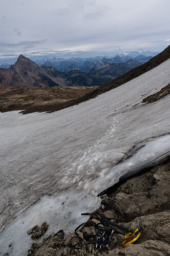
I assume this route in the North Cascades in WA (deep cut for a previous out of control thread last year lol) would be YDS 2, but SAC T5.

I feel like the number of people who are going to dig into the surface=* of a path are pretty small. I guess a renderer could detect the surface and SAC level and come up with a way to render some warning about crampons, but we fall back into SAC not being well known outside of Europe (and glaciers occur worldwide).

I still like the idea of expanding hazards, they’re more specific and useful. A value that is essentially “crampons and ice axe needed” ala Secor is a lot clearer than someone seeing T5, looking up surface, checking that T5 path is only for ice and not rock so it refers to that section and not another, etc.

I personally feel once you’re past foot_scale=simple_scramble you shouldn’t be relying on OSM to safely do a path/route, it’s worth looking it up in some more long form way elsewhere more suited to more technical / nuanced terrain. It is useful to know that it’s difficult enough that doing so is a good idea though!

Looking at the photo above: If You need crampons there, then it is not T4, because T4 specifies trekking boots good enough. For You, this then would be T5. I can imagine walking there with sneakers, attentive for sure; Certainly, for Me, the choice of footwear alone would not make it T1 :wink:

There might be a US / non hardcore EU centric bias of votes here or something but there seems to be a strong majority thinking YDS 4+ and SAC T5+ shouldn’t be in paths, and a less certain ambiguous feeling that OSM currently allows this.

  • Move YDS 4 and SAC T5-6 (non-ice) into climbing=*
  • Create a new highway type for this specific terrain.
  • Have foot_scale include a YDS 4 / SAC T5-6 value with caveats
  • Just have foot_scale go up to YDS 3 / SAC T4 and leave higher grades ambiguous
  • Other (comment below)
0 voters

Beware there’s less than a handful of people voting or replying here…

6 Likes

I was going to mention the small sample size in the comment, but didn’t bother. I’m not sure how to get more input without making it a formal proposal, and generally once a formal proposal fails it isn’t seem as worthy of proposing again later.

I think I’ve come up with yet another better solution for the upper end of the scale. sighs hopefully

This probably won’t be ideal for hardcore alpinists, but we’re not the focus here.

What if value six is just something like requires_equipment? requires_tools?

Most terrain that is above simple scrambling recommends that (novices at least) use rope and helmet. Obviously there are people that can free climb El Capitan etc, but let’s say “non-specialists” or something. :slight_smile:

This also would cover any travel on a glacier that requires crampons, or paths that are so overgrown you’d need an axe or saw etc (this latter gets more into the spirit of @Hungerburg’s fork into walking_scale=not_walkable).

While some people (including me!) would consider walking on a mildly angled glacier with crampons easier than simple scrambling, if I didn’t have crampons that would be different. All terrain that requires equipment is, I think, a very good check for a casual person.

Having hazards that match up with this could be useful too - traction required, overgrown, deep pools for flotation, etc that could indicate the type of equipment required.

Local scales with more granularity over terrain that requires equipment will still exist, SAC etc. They can be tagged along with this value for more information for us technically minded folks.


Value 6: Requires Equipment

Editor description: These paths are not safely or comfortably passable by non-specialists without use of equipment.

foot_scale=requires_equipment

Paths that fall into this would include:

  • Travel on a glacier or areas that hold ice that require ice axe and crampons.
  • More difficult “semi-technical” scrambling that overlaps into easier technical climbing (YDS 4 goes up to YDS ~5.5, SAC T-T6 goes up to UIAA I-II, BMC 2-3 recommend ropes and helmets).
  • Abandoned or infrequently maintained paths that are so overgrown to be impassible or near impassible without use of an axe or sawm.
  • Terrain where you could get stuck or need to swim, where having a flotation device, a winch, or swimming could be necessary.

There is often little to no sign of being a proper “path”, though it is a route that people have done before. Many countries don’t print semi-technical scrambling routes on maps, though such terrain may show up on informal paths.

Expectations:

  • Accessibility: You should have the proper equipment to safely traverse this path. Further research is necessary.
  • Focus: Loss of focus can have serious or fatal consequences.
  • Footwear: Something specifically designed for the rough terrain would be appropriate.

Roughly equivalent to local scales: Class 4 YDS, Bouldering VB, SAC T5-6, UAII 1-2, Austria “Alpine Route”, CAI EEA-EAI, AWTGS 6?, PWS T3-R?, BMC Grade 2-3.

1 Like