RfC: New Key foot_scale=* ("now for something a bit recreational")

From the point of the view of someone who works on rendering walking oriented maps, I think this scale has a lot of promise.

At least in the UK, the distinction between highway=footway and highway=path is a mess, and having foot_scale apply to both (as well as highway=bridleway) would help provide a consistent framework.

For a data user (rendering or routing), it would be helpful to set expectations about associated tags:
Casual: Expect surface tag. This would allow “engineered” paths/footways (sidewalks etc.) to be distinguished from “natural surfaces”. surface not relevant for higher categories.
“Not walkable”: Expect sac_scale or some other tagging indicating hazard. I assume that these would normally only be brief stretches on a longer path. [Alpine maps often indicate such ‘difficult stretches’, which is very useful when route planning.]

I’m struggling with the distinction between “surefooted walking” and “impeded walking”. You probably don’t want mappers breaking trails into fragments with more-or-less subjective subtle tagging differences. This is where the 5 point scale for tracktype doesn’t work well (tracks often vary). It might helpful to express guidance in terms of “overall difficulty / challenge” for a particular section between one junction and another. This seems to be the spirit of foot_scale and an important distinction from physically based tags such as tracktype, smoothness etc.

I’m afraid that for a data user, this tag won’t change anything and in particular won’t prevent micromappers to micromap. You will have to generalize the tag yourself between junctions if you want so.

1 Like

Funny, two days earlier two claimed casual walking and no one objected, now nine out of eleven claim attentive for the very same picture; Eleven of eleven claim attentive for a path, that is different only insomuch as in season and moisture of the ground.

I have no strong preferences, so I did not take part in the quiz. I’d be fine with both. All this tells me, the definitions need an update to get more predictable results. From casual observation, so to say.

Risking to draw even more ridicule than already, Casual seems not a good choice, especially for a low anchor. @erutan coined the term at a time, when topic was fully hiking trails oriented. As already said, casual is not trivial to translate into German - https://translate.google.com/?sl=auto&tl=de&text=casual&op=translate Translating to French seems harder still - https://translate.google.com/?sl=auto&tl=fr&text=casual&op=translate - sport there ranks even higher than in German.

Most people don’t see the overgrown coming at the heart of summer, especially on a photo :grin:
That been said, we are human, so don’t look too much at clearcut mapping.

Hello there. Discussion is a bit at a dead end. Any fresh input welcome!

This scale is all subjective. Imagine a very rough path somewhere: A number of skilled people can walk all of it hands-free, some people will use hands (especially people that are not sure-footed) in sections, even the skilled occasionally do, if for convenience only. If you lump impeded and surefooted into one, you will not be able to learn if there are any of those sections and how much distance they cover.

I’d like to test this idea further: The more levels, the less damage by a miss, at least as long as off-by-one. Prevents edit wars.

So, the low side needs one more value too - I’d call it just “walking” and the promise being, that it does not change much from season to season or whether its raining or not.

Consequently, casual must get a different name - indicating that some minor inconveniences apply - Can you suggest an English term that fits between Walking and Attentive walking?

I believe you are overthinking this. Yes, the scale is subjective to a certain extent, just as is sac_scale or smoothness or tracktype or pretty much any scale that attempts to map the messy reality into a neat finite set of boxes.

I may be the only one who voted casual for #2 rather than attentive, and I can say it’s an edge case, according to the working definitions. Had I had actually walked there and later discovered that someone else had already mapped it as attentive, I certainly would not “edit war” over it.

One just cannot fix the necessity of mapper’s subjective judgment with an ever more detailed set of criteria – in the end, you may just end up with a tl;dr wall of text that casual mappers will not bother to read. Keep it straight and simple, please. I really think that what we’ve achieved so far is both workable and useful, and I’m rather impressed how the emerging proposal has progressed so far.

And I’m also participating in the parallel industrial tagging discussion, which has been going in circles for quite some time.

5 Likes

I have no interest in creating something like trail_visibility, where excellent matches almost everything and good means there may be nothing.

PS: For something recreational, https://youtu.be/kB-fXoY9rtM?t=420

And no one is suggesting that!

Most respondents said both pictures above should be “attentive walking”. This means the barrier for something to be considered “casual walking” is quite high: if a path has no obstacles, but is so narrow you need to watch your feet to make sure you stay on it, it’s “attentive”. That’s fine with me, and can be added to the definition (and I’m one of the people who originally voted “casual” for the second picture).

It doesn’t mean we need another value, or that “casual” can’t be the bottom value.

1 Like

If you lump impeded and surefooted into one, you will not be able to learn if there are any of those sections and how much distance they cover.

I’m sure the distinction can work, but it would make sense to align with the existing sac_scale so that foot_scale is complementing (and effectively extending to non-mountain areas / casual walking). sac_scale seems to be quite fine-grained to me, but is clearly understood / workable for alpine areas.

The more levels, the less damage by a miss, at least as long as off-by-one. Prevents edit wars.

Not convinced. My experience with tracktype is that the number of levels makes it difficult to choose, and so I don’t bother (especially as it varies). I would require/expect a survey_date tag, to emphasise that foot_scale is about on-the-ground experience. This should limit armchair edit wars.

So, the low side needs one more value too - I’d call it just “walking” and the promise being, that it does not change much from season to season or whether its raining or not.

Possibly. I think what is being described is the level of determination / preparation needed to tackle a footway/path. The bottom of the scale is “no thought required” (sidewalk, engineered footway, in public space). You could have a level for a way that you wouldn’t necessarily automatically take, depending on conditions (e.g. lighting, soft surfaces). The two examples above might be this level of “I’m taking this path for a reason”, but you could still be staring at your phone and not paying attention to the act of walking.

I can’t think of a good word for this, but at least if you can express the concepts in terms people can use, the battle has been largely won.

I have no interest in creating something like trail_visibility, where excellent matches almost everything and good means there may be nothing.

This is still useful up to a point, but only really as a binary marker for “this path is invisible on the ground”. Otherwise it is not especially useful, especially if you are following a marked trail with with a GPS device. The visibility of a trail could still be a factor in a “determination needed” scale, i.e. a path with bad to zero visibility might automatically quality for “attentive walking”.

1 Like

At this point, I only see one way forward: Stop pretending to be a foot_scale applicable to anything that has foot=yes. Instead be upfront, that this is meant for paths used for hiking, stroll-walking and other pastimes. I suggest to continue this in a fresh topic.

trail_walkability = casual | attentive | surefooted | impeded | no

The name of the key echoes trail_visibility, which is also about outdoor activities. They will be perfect siblings/cousins. This here – starting from the great work by erutan – is already far better than trailvis, it was a pity if all the effort that went in it were in vain.

The poster who received most of the likes in this topic has the community mandate to get before the carriage :slight_smile: Feel free to clone the FootScaleGallery and copy-edit to your hearts desire. Perhaps https://wiki.openstreetmap.org/wiki/User:Duja/TrailWalkabilityGallery ?

I’m struggling to follow your thoughts… can you explain what the problem is?

You wrote an RfC and created a gallery. Seven people added pictures. Most people who commented said it was a good idea. There are clearly a few things that need to be improved or clarified before moving to a proposal, but on the whole there is widespread agreement about how the different values should be used. For one of the pictures you posted, 11 people agreed unanimously which of the five values should be used. Surely that’s a level of agreement unheard of for a five-point scale in OSM!

1 Like

I think this will run into the same issues at the lower end of the scale. Instead of mappers asking themselves “is this level 1 or level 2 on foot_scale?”, they will need to ask “does this qualify for trail_walkability”? That seems just as difficult to me. Any easy path can be used for strolling. I guess maybe sidewalks could be consider not primarily for leisure walking, but what else would be excluded under this definition? Almost any path in a park, for example, is likely to be used mainly for leisure. The smooth paved path I included in the photo examples leads only to a viewpoint at the top of a hill, so everybody using it is walking for leisure.

If your concern is that there will be a lot of “trivial” tagging where it adds little value, I think the suggestions above that foot_scale would not apply to paved surfaces are potentially useful. That would exclude a large proportion of paths using something objective that matches an OSM tag. It seems much easier than having to decide whether a given path is used more by people strolling than people walking to work.

2 Likes

I live in the Alps, sac_scale does everything I need, for my rambling and scrambling activities.

BTW: There is only one click registered for this link https://youtu.be/kB-fXoY9rtM?t=420

sac_scale can rely on literature. Mappers do not have to decide on their own but instead copy (the middle/the median) from some other source. Such I heard in CS arguments.

Curiously, the 2023 change by the SAC regarding their mountain hiking scale also reflects a bit on that platform use: Where previously UIAA II scrambling was exclusive to T6 now short stretches of UIAAII might be in T5 and T6 may mean long stretches of UIAA II.

Actually, if you read the documentation, perhaps “good” might the tipping point. Local mappers that enter new paths give good to such trampled paths as shown in the polls above. A certain mapper from a neighbour country likes to change sometimes to excellent, because there are no pathless gaps, the path being visible throughout. Such inconsistencies may make life hard for consumers. To fully get the meaning they had to correspond the value to who mapped it.

I see this as closing notes, please excuse a subjective account:

When foot_scale appeared in the hiking_technique talk, this seemed to me a worthwhile invention - a key for anything pedestrian: From what municipal construction provides to barely, but still walkable wilderness paths.

My thanks go to all that contributed to the Gallery. Especially I’d like to thank @alan_gr for reading my ramblings at a time discussion already shifted to something that makes casual walking a synonym for sac hiking. The result of that shift being, there is nothing for me to gain from this effort.

Think of this a torch relay race: Takers welcome! Please start a fresh topic!

Coming back to this after a break, I’ll try and look at photos later and contribute some in the next few days.

Instead of directly quoting people I’ll address some issues I have repeatedly seen here and/or have been bouncing around in the back of my head for a bit.

this is no longer a foot_scale

This should just be called something like walkability scale - all the values refer to walking. trail_walkability doesn’t feel right as it isn’t just for trails, but I had been thinking of dropping the suffix because it seems redundant. path_walkabaility would make sense.

Given the reworking of values 4 and 5 this scale is now firmly aimed at non-technical paths. That’s not necessarily a bad thing, but it leaves a large gap in between it and technical climbing for legitimate paths. I would lean into saying that YDS 4 / SAC T6 are more “routes” than “paths” especially as they get into what is considered technical climbing. There are however a good amount of legitimate commonly used paths that include some simpler scrambling - I’ve been on them in California, Utah, New York, Argentina, Chile, and New Zealand. Just labeling them “unworkable” seems… weird to me. And in ALL of these cases people would consider themselves to be on foot. foot_scale to me was meant to cover when people are on foot, stopping at technical climbing while refocusing on the lower end of the spectrum where the majority of users are.

The top value seems a bit odd to me. How many paths in OSM are caving crawls? If someone has to duck under a tree or chockstone and they are no longer “walking” does that make a path unworkable? If I’m on some surefooted terrain I could be “hopping” and on some “impeded” terrain I’m often leaning on hand on talus and cantilevering around it etc which isn’t “walking”. This scale seems to peter out on the simpler side of YDS 2 / SAC T3 which leaves a lot of room up through YDS 3 and SAC T4/5. Having spent some time boulder hopping in Joshua Tree recently I was definitely “on foot” but not “walking”. Having some plan for semi-technical terrain aside from “just use SAC worldwide” would be nice to see.

@Hungerburg in the original thread agreed that terrain up to T4/5 is “on foot”, and @Adam_Franco gave some examples of fairly regularly occurring non-alpine terrain on paths that would just be “unwalkable” here. What does that mean for people?

I think it could be worth proposing this walking path scale, and then alongside it present a modified version of the foot_scale as opposing options each with their pros and cons. I came up with the original idea and values, @ezekielf came up with the name, a lot of people contributed to the discussion and then it was sort of redefined (for better or worse!) in this new thread - it’s more of a fork of the original idea IMO.

impeded doesn’t feel quite right

I can be walking down a sidewalk and be impeded by other pedestrians, or have to brush a branch out of the way. I know it’s hard coming up with a single word, but I’d lean more on the original thread that was centering on something like hands_for_assistance or assisted_by_hands.

the lack of detailed descriptions for values leads to ambiguity

I don’t think mine are perfect or complete, and having a one line subtitle of sorts below each would make sense (that would get pulled into an editor) for skimmablity makes sense, but keeping them to a single sentence tops leads to more “interpretation” like we currently have with the SAC derived trail values.

The original value descriptions at least tried to address some of the comments here about someone with mobility or strength issues pretty directly.

One thing rattling around in the back of my mind is that it was too focused on “obstacles” and mentioned traction but traction is a big part of it. If a path has deep sand, is typically muddy, or is slick from being near flowing water etc terrain without roots or rocks in it surefooted. Likewise a typically dry path right after rain should be probably kept at its casual/attentive base.

The overgrown scale near the top doesn’t feel right to me. The values make sense against the value names, but there’s a big difference between surefooted walking on smaller talus and a walking through tall grass on an even surface, or having to push branches out of the way vs more dynamic moving on larger talus requiring use of hands to push off of rocks etc.

I can easily think of a trail that hasn’t been maintained for decades where I had to push through some tree branches but wasn’t any harder than attentive_walking as they had little resistance and the path was still solid single track underneath, and coming down a uneven slope with ankle high grass on loose ground where I was concerned about my traction and was surefooted.

Overgrowth can also be seasonal - I think it’s better suited to be it’s own tag perhaps, or people can just think of how it impacts the path in the context of the existing values and expected requirements / experience.

People can come up with perfectly reasonable 1-5 scales for mud, sand, etc but they won’t map onto IMO the point of the scale which is to help people pick terrain they or others will be comfortable with.

separations of concerns

I’m still for disambiguating exposure from this scale. We don’t have a workable hazards/obstacles key or (less likely) an exposure one but it’s entirely possible to have a significantly exposed attentive_walking that is very different from a scramble.

Anyone that is capable of attentive_walking can do this (not my photo, it just came up recently) - if they’re comfortable with exposure. If we just bump it to, what unwalkable that’d be… weird. If we bump it up to say impeded walking that doesn’t make much sense to me as it’s a very different experience than being on talus etc. It’s definitely not “unwalkable” despite being very exposed. Less physically demanding (though some coordination is needed, it’s not casual) but more psychologically demanding.
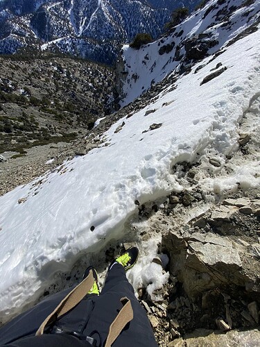
I know paths that seasonally are overgrown and I walk them, while I do not see the path on the ground, just the vegetation, knowing that there is a path, putting my trust into that only from assessing terrain. I’d have no problem calling that sure-footed.

All the while, I see my attempt at creating a foot_scale failed, i.e. something not for the niche of ours but for the general populace. Here photo of one of the buttons on the jacket of mine that I use to wear in what is winter according to calendar:

I’m not sure it’s a failure - I just disagree with the approach. I could be wrong. :slight_smile:

If you’re going to change foot_scale to exclude terrain that requires experience or technique to manage, it’d be good to have at least some plan for how to deal with terrain that has more than a “casual use of hands” that isn’t technical climbing or global SAC. If we’re drawing the line at non-casual use of hands, hopping across rocks, having to do a little mantle over an obstacle etc we’re writing off some commonly traversed paths as “unwalkable”.

I wasn’t taking “trail condition” photos back in 2016/2017 when I did more international hiking, but the hut at mount cook was full up of people despite the trail being unwalkable in sections, and many other trails there had similar “pull yourself up by roots up a muddy slope” bits. Argentina and Chile had a lot of trails that required some non casual use of hands, but those tended to be a bit more remote and “alpine clubby”. Around a third of the trails in Acadia National Park (that aren’t just carriage roads) would be unwalkable despite them getting consistent use. The northeast US in general has a lot of trails with scramble sections in them - my partner rolls her eyes at all the low angle switchbacks out west.

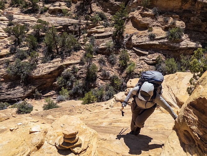
Is this photo “impeded walking”? It’s casual use of hands, but it’s fatal exposure. It doesn’t feel “impeded” in that the hands are optional and more for emotional support due to the exposure (I held on as well lol). We encountered dozens of people were hiking this (slightly off-season) ranging from some backpackers to trail runners to random people from the midwest.

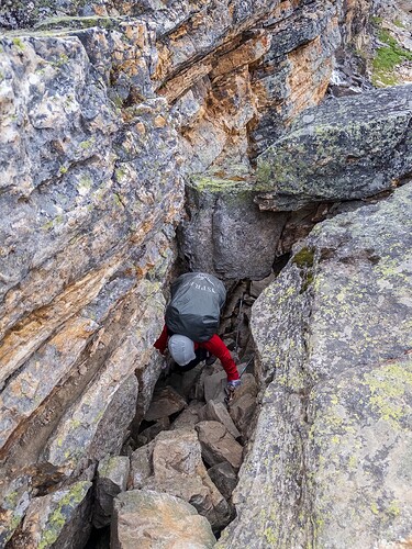
This path required ducking under the chockstone and then mantling out of it, which isn’t walking and is questionably casual use of hands. This is basically the crux of the trail, 98% is pretty normal single track and it’s pretty heavily used. Unwalkable sounds more imposing than it is I think. I often have to duck down and crawl with a full pack on trails that have occasional obstacles that are otherwise fine (and after a heavy winter or wind storm there can often be temporary “unwalkable” 1m sections caused by a fallen tree for months - should someone tag that trail unwalkable it’d be a concern).

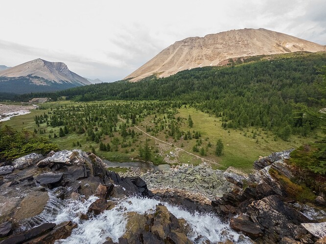
This is what most of the trail looked like (though there was one surefooted section along a lakeshore). I think an obstacle node would be more appropriate than a full path level rating for that in any case.

I considered another popular trail in Canada up to an alpine lake from a lodge to have a casual enough use of hands that I went up it basically walking with hands for balance T3. I’d still probably put it at T4 (that photo was shared before, I drew steps under where I went, was taken with a wide angle lens).


I think I’m pretty aware of how casual people respond to terrain (from talking/observing in various types of terrains, running a community based on alpine conditions for a range, seeing people talk about routes in online communities etc) but I also am wary of under-estimating them. Children can “scramble” on playground equipment quite well! My partner’s 65 year old dad regularly goes up a path that has a little T4 section in it and he’s a pretty casual/normal person that doesn’t climb or mountaineer.

All that said I think it’s important to let people know what to expect they’re getting into (though there’s a large group of person that just see a path and walk on it blindly). Honestly for the average healthy able-bodied person exposure is probably more important than a technique/terrain based scale - I know people that are fine with a little scramble that wouldn’t do the “walking” photo at the end of the post above. But bumping up a walking/technique to account for exposure feels very weird to me.

Something like this rendered would ideal (that’s a loaded idea of course) vs just bumping up technique to account for exposure.


re: overgrown I feel like there’s enough variables in it (seasonality) where trying to fit it 100% into some kind of foot scale is problematic. If a path is overgrown, and always will be overgrown, that’s different from one that is seasonally or only in a short section or two with solid trail underneath. I personally feel like it can be a fairly unique factor. Short bushes on top of small talus is awful, despite the overgrown aspect being potentially simple in and of itself.

In regards to the walking below casual walking level - that would probably be technically covered by a casual value combined with a surface that is paved or compacted, though even sidewalks can have little uneven sections due to roots here or there. wheelchair=yes would be useful for that.

That said I highly doubt very many people are parsing multiple OSM attributes for paths and tags like smoothness have massive issues when applied to on foot travel.

1 Like

Minimum Trail Width

One idea here that I really like is having there be a minimum width for a casual trail. That’s generally how I picture them in my head, and it can easily be argued that needing to stay within a single track path requires some degree of attentiveness. Wide paths can obviously be surefooted (or more) as well, but after pondering it I think no narrow path should be casual. This also aligns with a lot of the comparative research I did - the National Forest Service in the USA and the agency in charge of trails in Australia all have wide paths for their lowest level of trail classification.

Instead of a fixed number (what if a path is 0.95 meters wide in a spot), I’d describe it something like “enough room for two people comfortably to walk side by side” and/or “enough room for two people to comfortably pass each other without stepping off of the path”.

This also gets around, a little bit, some concerns about exposure as at least people are always on a wide path.

On that note, I wouldn’t mind also stating that any exposed path has to be attentive. I do still feel that the long term view is having a path which could be attentive or surefooted and then have an exposure or cliff or steep_slope hazard along it (which is more informative than saying attentive terrain with exposure is surefooted, and surefooted terrain that is unexposed is also surefooted).

Some further thoughts on the emphasis on keeping this “walkable” and how anything above walking is somehow harming the recreational user.

The amount of formal paths that are T5 or higher globally has to be quite low (I’m sure someone can pull up a report on this). I’d imagine they’re concentrated in certain European countries (some don’t consider such routes as paths to be put on maps), and the British Isles. I don’t think I’ve come across a formal path in North America that has any T5 terrain, at least not extended - I can easily think of quite a few informal ones, as well as plenty of off-trail terrain I’ve done. I’m sure some exist, but it’s not a common issue! Short stretches of T4 are fairly common, and in certain areas there are definitely paths with longer stretches of T4.

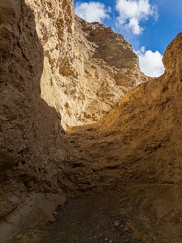
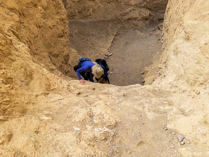
A week or so ago I did this trail in Death Valley:

It’s listed as a moderate hike on the overall listing, but the detailed page says to moderate to difficult. It was mostly attentive terrain (wide, but with some obstacles/variation yet no need to walk on uneven surfaces) aside from the following crux, as described by NPS:

One mile into the main canyon, you encounter an 8ft (2.4m) followed soon after by a 6ft (1.8m) high dryfall. Climbing up may seem easy, but proceed with caution, especially when hiking alone. Climbing back down is always more difficult.

This is definitely not “walking”. I saw a 2 small groups coming or going further up or down the main canyon as I was dropping back into it, and passed a group of 5 elderly hikers above the obstacle. I got there as a slightly younger couple was dropping down it - the husband went first, then helped guide his wife down. I thought this was an interesting moment so chatted with them about how they felt about it and how they perceived it etc. :slight_smile: They weren’t entirely comfortable, mainly due to the lack of handholds, but it was well within their capabilities. Neither knew what YDS or exposure meant, though they seemed well versed in the outdoors it had been 5 years since they went backpacking though they aspired to go again. They were impressed the older group went up it.

I’d put them as “recreational” users personally, though more experienced than your average casual tourist. I think in this case having a hazard node would be useful (8ft drywall, climbing/scrambling required) or something, and they agreed.


(the dryfall)


(the down climb)

I don’t think that having a slightly more aggressive “hands for assistance” as is commonly understood in multiple international systems (YDS 2, SAC T3) and than a “scramble” (most likely around T4 difficulty to low T5 in most of the globe) doesn’t somehow make the bottom 3 values meaningless or hard to understand. Most of the “unwalkable” terrain to me feels like node hazards (having to duck under a tree or overhanging chockstone, needing to hop over some boulders, deep mud, etc). I’m not sure how many people are following long cave paths in OSM data (GPS certainly isn’t useful) or fords that require swimming. I can think of cases of the latter, but these tend to be deep pools in a canyon and could again be marked with a node. Pushing through bushes would, to me, be considered using hands for assistance.

Knowing what those higher difficulties are (non-causal use of hands, scrambling) I think is more useful than just having there be a second scale that covers unwalkable terrain that people then have to use or look up.

I’ve been updating the original foot_scale idea, and finally have a slower stretch of time where I should be able to start contributing more again. A lot of good ideas in this thread, even if I disagree with the direction taken. :slight_smile: