RfC: New Key foot_scale=* ("now for something a bit recreational")

Well, got waylaid with some engine issues on my vehicle and a client coming out of the woodwork, but here’s where I stand on foot_scale. I’ll probably make a splinter thread soon (I’ve been gathering a lot of photos on different terrain / areas) but figured I’d toss it out for some quick feedback if anyone is interested. I’ve taken a lot of good points from this thread and incorporated them!

I’m curious if people find it better or worse. It’s certainly not as terse, but I personally feel it probably helps avoid ambiguity as well as set expectations for more casual or recreational users while transitioning into “semi-technical” terrain. :slight_smile:


Value 0: casual_or_attentive_FIXME

foot_scale=casual_or_attentive_FIXME

This value would exist for data ported over from the existing sac_scale T1, as there’s no real way to tell if the path should be either casual or attentive.

Value 1: Casual

foot_scale=casual

Requires little to no attention to traverse, very accessible

The ground may not be entirely smooth and clear but it has few to no obstacles. If there are obstacles they are to be minor and/or have a large amount of space around them. These paths can often use imported materials for their surfaces (gravel or asphalt), but can also be on naturally occuring firm ground where traction is not an issue. The path must be wide enough for two people to walk side by side or for two people in opposing directions to go past each other without stepping off of the path. Steep drop offs must have a railing or some other means of protection.

Expectation:

  • Accessibility/Safety: In general anyone that can walk (even with some mobility issues) like those that need to use a walking aid, the very young and elderly, etc can safely traverse this terrain.
  • Focus: Little to no focus is needed, people can walk and talk and not pay much attention to the path surface.
  • Footwear: Almost all casual footwear will be adequate.

Roughly equivalent to local scales:Class 1 YDS, ~NFS Class 4-5 Trails, SAC T1 / Yellow, Austria Blue, CAI T, AWTGS Grades 1, PWS W1 & W2

Note: Casual walking paths that are wheelchair accessible should be tagged with wheelchair=yes.

Value 2: Attentive

foot_scale=attentive

Requires attention to traverse, but still relatively straightforward

These generally are either narrow enough that people need to walk single file (and step off to pass), have steep unprotected drops off of the side, or some modest yet impactful obstacles. Obstacles are generally ankle to knee high like roots or rocks - though these can almost always be avoided and it is possible to walk on an even or nearly even surface. The surface itself still provides good traction regardless of obstacles, but you may need to pay attention in places.

Expectation:

  • Accessibility/Safety: People that need to use aids when walking, or have a minor issue that impacts their mobility can have problems in sections but should be able to safely complete it.
  • Focus: People need to be attentive of obstacles or footing to avoid tripping or slipping, but can still split their attention to easily carry on a conversation etc.
  • Footwear: Sneakers or other casual footwear should be fine.

Roughly equivalent to local scales: Class 1 YDS, ~NFS Class 2-3 Trails, SAC T1 / Yellow, Austria Blue, CAI T, AWTGS Grades 2, PWS W1 & W2

Value 3: Surefooted

foot_scale=surefooted

More complex terrain that requires surefootedness to traverse

Where attentive path surfaces have obstacles that can largely be avoided, this terrain requires people to be able to move with balance and coordination (be surefooted) to maintain traction. Having to lift up your legs to move over uneven rocks and roots and then step down on an uneven surface for an extended period of time is common. It can also include moving through mud, wet clay, slick or loose surfaces, etc where the surface itself is essentially an obstacle due to poor traction. A path is also surefooted if it is obscured enough you can’t see where you are stepping, as you may need to react quickly if stepping onto an uneven or loose surface.

Expectation:

  • Accessibility/Safety: If someone has mobility or balance issues they may be unable to proceed safely or comfortably on this terrain. This can be very challenging to inexperienced hikers, but will be straightforward for mountaineers.
  • Focus: Attention will need to paid to footing for long stretches in places to avoid loss of traction or falling.
  • Footwear: This is more consequential. Lightweight but outdoorsy shoes like trail runners or approach shoes would be helpful, but sneakers should still work though more care might need to be taken at times. People with bad ankles or that lack experience may want traditional mid or high top boots.

Roughly equivalent to local scales: Class 1 YDS, NFS Class 1-3 Trails, SAC T2 / White-Red-White, Austria Red, CAI E, AWTGS Grade 3?, PWS T1-T2

Value 4: Hands for Assistance

Rougher terrain requires hands for balance, or to push off/pull onto/pass through obstacles

foot_scale=hands_for_assistance

The path surface that is uneven or steep enough that it’d be reasonable to expect people to require use of their hands or trekking poles to safely traverse it. Obstacles like larger talus or boulders where you need to put a hand on a piece here or there to support yourself, aid with balance, or move around it. You might be occasionally be pushing off or pulling up on obstacles, but you aren’t actually using them to scramble or climb and you aren’t searching for mulitple handholds in a row. Having to actively push through bushes or branches to proceed as opposed to just brushing them out of the way occasionally would also fall into this category.

Expectation:

  • Accessibility/Safety: You need a stronger sense of balance and coordination than on surefooted terrain. Being able to control your body’s momentum and be aware of your weight and how it is moving over obstacles is important.
  • Focus: Intense concentration is often necessary. The ability to think a few steps ahead and a little bit of confidence when focusing on the path are very helpful. :slight_smile:
  • Footwear: At this point something with grippy soles meant for hiking is recommended. These can still be very lightweight for experiened individuals.

Roughly equivalent to local scales: Class 2 YDS, NFS Class 1-2 Trails, SAC T3 / White-Red-White, UAII 1, Austria Black, SWW White-red-white, CAI EE, AWTGS 3-4?, PWS T3-T4?, BMC Grade 0.5?

Value 5: Scrambling

More vertical terrain where hands are used to climb/scramble, but is simpler than technical climbing=*

foot_scale=scrambling

Obstacles: High angle obstacles that need to be “climbed” finding handholds and footholds and pulling oneself up, but are simpler than technical climbing=* which use of a rope and harness are expected. Feet are off the ground for more than a few moves, or there are repeated sections of short climbing.

Expectation:

  • Accessibility/Safety: You need to be able to pull up your body weight with upper body strength. While not considered “technical climbing” significant risk can be involved. Previous climbing or mountaineering experience is highly recommended.
  • Focus: Loss of focus can have very serious consequences.
  • Footwear: approach shoes, “high route shoes”, cross trainers, or boots are recommended. You’ll generally want either more traditional boots with “structure” or a lightweight shoe that conforms to the foot for better feel and independent use of foot muscles for control.

Roughly equivalent to local scales:: Class 3 YDS, Bouldering VB, NFS Class 1 Trails, SAC T4-5, UAII 2, Austria “Alpine Route”, CAI EE, AWTGS 4-6?, PWS T3-R?, BMC Grade 1-3

OSM Mapper Note: Some hiking systems overlap into technical climbing - SAC T6 regularly covers extended UIAA 2, YDS 4 goes into the lower range of Class 5, etc. These are far closer to technical climbing routes than recognizable paths that people can follow on foot, and are not appropriate for this scale. This is going to be a slim minority of paths in most regions.

Just marking a section of a path as a scramble is useful. More technically minded people can add on a local scale to help differentiate grades of scrambling - BMC, YDS, SAC, etc.
5 Likes

All sounds good to me!

Question though - would you split the path into sections of Casual, but with Attentive & Surefooted here & over there, or add a “Attentive” node at that spot?

1 Like

This is a discussion that probably needs its own wiki “how do I?” page at some point, here’s my take from a while back.

1 Like

The way I generally see these breaking down:

casual will be most common in urban and “roadside attraction” tourist paths

attentive will be most common in general wilderness paths.

surefooted will the vast majority of the time be less common than attentive, but still occur regularly in more aggressive terrain, in areas with lower trail budgets, and/or where operators want to provide a more wild experience.

however in some areas surefooted could be more common, and not just in typical alpine environments. a lot of tropical terrain is surefooted due to being generally slick and/or covered in roots (Hawaii, a few countries in SE Asia I’ve been to) even if not traditionally mountainous.

hands for assistance is where things really begin to gatekeep people… but in areas like the US Southwest there are regions where probably 1 in 3-4 paths require hands for assistance. We saw a family of six including four small children go up a path with multiple mantles and some uneven steep bedrock in places etc. and then there’s obviously mountainous terrain.

scramble will be nearly absent in some areas, but only somewhat uncommon in others. Parts of New Zealand, the North East of the US (New Hampshire’s Presidential Range, Acadia, etc) often have well marked visible official paths that require some scrambling. Interestingly while I scramble quite a lot in the Sierra Nevada, no formally maintained trail comes to mind, and even the hands for assistance ones are almost always unmtaintained or kept at a NFS Class 1 rather undeveloped management standard.

I love the last proposal, thank you.

Where does trail steepness come into play? Obviously, we can specify it explicitly using incline, but it also affects walkability of the trail. I know paths that are of solid, compact ground that would normally be classified as casual or attentive at worst, were they not >20% percent steep, and thus not a place you would send your elderly grandma or a family with toddlers. If we want to subsume all aspects of “walkability” into foot_scale (do we?) this should be addressed as well.

2 Likes

Not so sure about steepness, this clearly doesn’t fit with casual, attentive and surefooted values.
I would be in favor to stick with incline.

I feel like the description for foot_scale=surefooted covers severe grades in two ways:

  • The way steepness of the way requires “balance and coordination” to move along it, focusing on the user’s “stability” or balance.
  • The steepness of the way requires high lifts or drops of legs for “extended period of time”, focusing on the user’s strength.

I think in this way it would make sense to tag very steep asphalt/concrete paths as surefooted instead of attentive when they pass the threshold of being easily traversed by those with much lower-than-average stability or strength.

3 Likes

Incline is one aspect, like obstacles and traction, that impacts how someone needs to move over terrain. How those all play together makes the experience, not any one in isolation.

That said at a certain point if someone is going up or down a genuinely steep slope (say 35-45 it’s no longer casual even if it’s paved.

I’m a little leery of relying on tags like incline, surface, etc as I feel like the very casual people that would need them are not the ones that are going to be reading them.

The expected experience would push such paths into either attentive or surefooted in terms of mobility requirements.

That feels like a fair reading, though I’d also focus on the expected experience / requirements section. I feel like that’s my fallback if there’s some weird wiggly edge case scenario - what does it “feel” like?

I personally feel like it’s fair game to start putting terrain in the hands for assistance bucket (YDS 2) when slope starts getting around 30-35° just because at that point you usually will want to drop a hand for balance here or there, or rely on poles for another point of contact. As I put it, the slope angle itself becomes an obstacle. That’s less of a formal path issue though.

I used to explicitly cover expected incline ranges, but then dropped it as it’s hard to make a precise rule on incline IMHO. A more moderate incline can be much more difficult on loose or unstable terrain than on a nice solid surface, but at a certain point inclines do become their own obstacle.

It used to be something terse like the following (thinking of how it interacts with obstacles etc):

Casual

Slope: Flat to mellow.

Attentive

Slope: Flat to moderate.

Surefooted

Slope: Flat to moderate.

Use of hands:

Slope: Flat to steep.

Scramble

Slope: Steep to very steep.

That doesn’t really mean much I guess. :slight_smile:


So to think about this out loud a bit:

casual = mellow flat to gently rolling terrain.

attentive = moderate angles where you need to pay attention to your footing due to the slope, but most able bodied adults will not be worried about the steepness.

This should probably cover at least up to 20° (iirc the US national forest service now tries to keep trails at or under 18° slope) if there’s good traction. I’d be tempted to not cap it there because it’s dependent on interaction with a surface.

Surefooted argh. I’m not really a fan of saying that going down a 25° slope is the same as being able to move over roots, boulders, have terrible traction etc, but at a certain point you need to be able to use your knee muscles to brake, stop your momentum, be able to recover when your weight is pulling you down etc. SAC includes a moderate even slope as a requirement in their T2, which surefooted is pretty close to (though they do it in a dumb way as example photos show someone on talus on flat terrain).

So…

surefooted = regardless of obstacles, the slope is steep enough that an able bodied adults needs coordination and leg strength to keep their balance and control momentum. Aids like trekking poles can be welcome, but not necessary.

hands_for_assistance = the slope is steep enough using hands or trekking poles is necessary to maintain traction and balance.

scramble = it’s, uh, steep enough you are scrambling. :stuck_out_tongue:

I feel like these capture the spirit of the ratings well, and aside from surefooted are still pretty compact.

1 Like

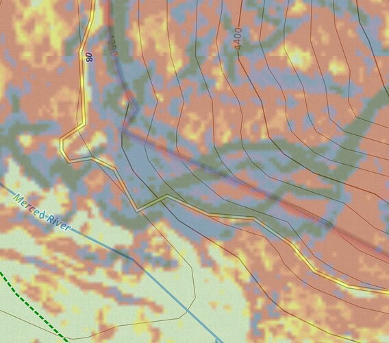
The climb up on the mist trail / JMT in Yosemite Valley comes to mind - I haven’t measured it with a theodolite but it feels like it’s at least around 30°. It passes through some 45° slopes and doesn’t have any switchbacks in it, though it can’t be that steep. I’ve ended a few trips coming down this into Yosemite Valley and the combination of slope, pavement, and carrying a full pack always makes my knees ache a bit.

That said young children and elderly people are able to go up it that would issues on surefooted terrain. A lot of people are stopping along the side to catch their strength. Hundreds if not thousands of people do this a day in peak season, and I bet that not all of them are surefooted.

I feel like it falls more under attentive than surefooted due to requirements/expectations - but it’s definitely not casual despite being a wide paved path.

Under attentive:

Under surefooted:

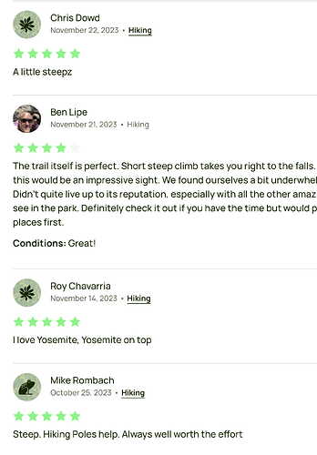
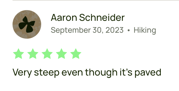
A lot of comments on AllTrails mention is as being steep, but it and the park service list it as a moderate hike. No one seems to disagree at least on the first pge.

https://www.alltrails.com/trail/us/california/vernal-fall-foot-bridge-via-john-muir-trail

Screenshot 2024-02-11 at 5.17.33 PM

This first paved mile of trail is busiest and accesses the Vernal Fall Footbridge. Almost entirely uphill, you can appreciate views along the way, and during spring, when the water levels are at their peak, you can also glimpse Illillouette Fall from this first section of trail.

NPS makes mention of the slippery steps further up the trail, but doesn’t think that getting to the footbridge will be an issue. They’re pretty conservative and would have a LOT of data on this.

Those steps are from natural rock, uneven, and often wet (hence the name mist trail).

further thoughts: obstacles that would make a path attentive if flat can make it surefooted if it’s steep. I’m not sure how to word that though.

I can think of terrain that falls into that “traction isn’t that bad, obstacles aren’t that bad, but at a steeper angle it’s kind of tedious but it’s not up to hands for assistance levels” surefooted category.

When I started this topic, I aimed at getting something short and sweet. Useful in editor presets. Soon I learned, not being a native speaker of the English language will earn my ideas just ridicule by native speakers. Not by you @erutan - I very much appreciate your observations. They are very spot on on what I observe, even though separated by an ocean and a language. Two notes:

  • 30° here is said the angle, where people stop going straight uphill, rather go serpentines.
  • SAC T2 says nothing about steepness in degrees, it only says, the climb in altitude is evenly spaced throughout the route.
  • That said, I do not think a 30° incline can ever be casual_walking.

I can live with being informed per mail of further deliberations here. I did suggest do create a fresh topic starting from current wording of what I perceive of hiking_scale=* :slight_smile:

1 Like

It’s a good attempt to make things as simple as possible. I liked that approach and borrowed that mindset for the short sentences at the top of every value.

Thank you, I’ve enjoyed our discussions as well and I’ve definitely been able to clarify some of my thoughts and abandon others from our back and forth. :slight_smile:

FWIW you’ve also gotten a lot of positive feedback and encouragement on your system here.

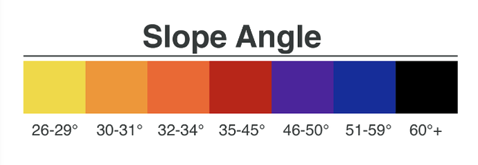
Maybe we’re thinking of different systems (degrees versus grade?). A steep staircase is 30-35°, and 45° is the angle of repose. I am definitely upright on orange to red slope angle shading quite a lot.

Ah yeah, true. Still poorly worded in my opinion hah. How much variance can you get before it’s not evenly spaced? If you have a flat hike with a single 10° hill is that T3, but a constant 30° is T2?

Ah yeah. I was going to get around to writing it up on the wiki with some example photos etc and wanted a little feedback… then it was simpler to just keep on chatting here. I’ll fork it soon!

I am talking about degrees, where 90 is the right angle. Perhaps it is about performance – going up straight steeper than 30 degrees being beyond of being what people are comfortable with expending in Watt-hours? What do I know.

I observed those people taking steep shortcuts, where I went the long way. I always catch them when they rest. I had a longer trip in mind.

Given foot_scale came up in the first thread (thanks @ezekielf) I’m going to keep it. :slight_smile:

I’ve splintered this off into a third thread and added in some language around slope angles into casual and attentive. hands_for_assistance already mentioned it, and scramble doesn’t really require it. I’m unsure of how to word it on surefooted, but feel like the accessibility expectation and general description give a solid vibe to work off of.

I’ve also tweaked wording a little bit here and there:

Ah, serpentines as in switchbacks! I was thinking of someone crawling prone like a snake.

In the western US they try to keep it a max of 18°, though that is partially to help prevent erosion. In the east coast they’ll just go straight up no matter what, and that’s often the case in New Zealand.

1 Like

The local rambling club posts signs “shortcuts destroy the vegetation” to remind people going the long way. We call the long way “Serpentinen” and certainly, the term comes from how snakes move. A proverb says, they only are there, because the craftsmen in charge of constructing the paths got paid by the length of the path, but this is considered humbug/urban legend.

To repeat: On paths or even tracks that steep, I do not think I can walk un-attentive of the ground.

1 Like

Yeah we have similar vegetation and erosion signs here “cutting switchbacks” is what it’s called.

I’ve updated the first sentence of casual to:

I’m hesitant about having X angle of slopes regardless of surface or traction be surefooted, but I have no problem laying a lot of strict guidelines for something to be truly casual. I do agree that high angle slopes require at least attentiveness and can easily hit the accessibility issues outlined for the attentive level.

FYI, this is probably of interest to you:

Thank you for picking this up again.

There is already a gallery here, do you agree with the pictures? Maybe you would like to add your own.

Could you explain what you mean by ported over please? The scale will get used as people tag paths they have walked, so they’ll know if it’s casual or attentive. If you are proposing some sort of mass re-tagging of objects without visiting them, then that would probably fall under the automated edits code of conduct and should be discussed separately, after the new tag has been approved. It’s likely to be more controversial than the new tag, and in my view it would only make sense in specific circumstances, e.g. in small areas where the local community agrees that sac_scale was never a good fit.

Since we’re not doing that any time soon (and possibly never), I don’t think you need to formally propose this “fixme” value.

3 Likes

Most the values map somewhat cleanly from the SAC scale aside from SAC 1 being indistinguishable whether it would go into casual or attentive. There could be some separate tag to indicate it needs cleanup like with some automated imports etc.

There’s been a few people saying that it isn’t useful unless it can be imported from the existing sac_scale so I included some potential way forward for that.

I don’t agree with this being a “walking scale” vs a “foot scale”. I looked at the gallery and most of them seemed consistent with the forked scale that was proposed in this thread, but my recent take on it would invalidate some of them (casual paths needing to be not single track etc). I could try moving those images around to where I think they’d fit on another page.

One small area I can think of would be all of North America.

Pretty much the only reason anyone here knows SAC is because they’ve travelled to Europe to do some mountaineering. I don’t know of a single person from the US that thinks SAC is a good fit for this local community of a country and I’ve seen it previously misused in Canada. :slight_smile:

5 Likes