As we were doing earlier today, on a track around the lower edge of a rock formation, & I thought about this idea!
We were on a formed, but moderately rough, track, & felt totally “safe”, but if you’d slipped / tripped / anything off the edge of the track, it’s ~50m down on a steep angle, full of boulders & trees!
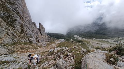
when I looked it up to find the video, I found a couple of texts that presented it as halfway between “vertigo hiking” (I did not know that expression) and “easy climbing”. As far as I remember, this is the only place of the route where you need to use hands.
It seems to me that we are struggling with two intertwined concepts: danger, and perception of danger. The point being that perception sometimes increases danger for good.
In theory, but that is probably too granular for a general hiking tag. I’m thinking that people can tag localized systems on top of this if they want - BMC, UIAA, etc. Having the technique on there as well helps with this - casual_walking vs scrambling have different likelihoods without getting into very fine details of terrain composition etc.
This has added two tags since it was made (unknown which isn’t really a meaningful value) then the airy_but_safe one which seems like a good idea.
what would make more sense? hiking_fall_risk or hiking_fall_danger come to mind for me.
I was thinking this over in my head and I think “long” falls is a lot simpler. I get hung up sometimes with exposure - “well I probably wouldn’t die if I fell here… maybe just some broken bones etc”. Someone can also die falling if they trip on the sidewalk and crack their head or snap their neck, so “fatal” isn’t reasonable. If I think in terms of mountaineering exposure I feel like if you aren’t climbing up a steep wall or on a knife edge ridge like the video above it’s wussy to think it’s the highest exposure rating.
Going back to long_falls_possible makes sense I think. It’s not like you’re going to be on some talus where you might have a small fall, or a trail where you have a trivial one, etc.
Without having been there I can’t really say (how steep, how wide, did traction seem good, etc) it’s hard for me to adequately label something. The Spencer Trail trip report I linked above falls into a similar category I think, many people do it, but some people don’t and even though a fall isn’t "likely’ it is possible there in a way that it just isn’t on flatter terrain.
I’d go with hiking_technique=surefooted_walking & hiking_exposure=long_falls_possible in that case,
This seems less parsable than a hiking_fall_risk, I’m not sure I heard the phrase vertigo hiking before and vertigo is a pretty specific condition.
Yeah. What are you being cautious about? Losing your footing and twisting your ankle or the toes of your boots being 3cm from a sheer 1000m drop?
Yes, but generally perception is there because of some danger.
Comfort with technique will also help alleviate perceived danger - a hiking_technique=casual_walking and hiking_exposure=long_falls_possible seems much more manageable than hiking_technique=use_of_hands and hiking_exposure=long_falls_possible to a non-mountaineer. I think combining those tags tells a useful (if still somewhat vague) story that has more information than just T4.
I think having some notes on common perception is useful, but trying to have a tag which is only perception based wouldn’t be useful unless there was some mechanism for multiple users to “rate” a hike and have different results show up etc (which isn’t in the scope or functionality of OSM).
I think the following make the most sense to me (a mix and match from my different versions above). The airy_but_safe could even go above short falls if we balance by perception vs risk. I think that actually makes some sense progression wise.
casually rewritten key overviews
trivial_fall_risk
terrain: you are unable to fall much further than onto the path you’re walking on. you might want to watch your footing on hiking_technique=surefooted_walking to avoid twisting an ankle or bruising your nose etc, but that’s about it.
psyche: anyone with standard coordination and balance won’t have fall risk affecting their comfort or discomfort of the path.
short_falls_possible
terrain: are are using your hands for balance on talus, going up a moderately steep slope, mantling up to a higher ledge, very near a short cliff, or on a very short scramble. you may fall, but it generally won’t be more than ~2-3m above the ground. still enough to do damage though!
psyche: some people will be very uncomfortable, the vast majority will be aware of it but not be too worried depending somewhat on the hiking_technique=* level.
airy_but_safe
terrain: long falls are possible around you, but there is human construction preventing or protecting you from them.
psyche: if you’re afraid of heights you won’t like it, but you won’t fall barring negligent behavior.
long_falls_possible
terrain: the terrain allows for longer falls that are either near a ~vertical drop or down a steep slope you wouldn’t be able to easily stop yourself on that could result in serious injury or death, but there’s enough space between you and the fall that you could still likely recover from a mistake or loss of traction without falling (or have it be a short fall instead). serious injury or death is still possible on this terrain, but would not be expected.
psyche: many people will still be fine doing this at lower hiking_technique=* levels, but people that are sensitive to heights could be very uncomfortable. experienced people with a “head for heights” will notice the risk but probably not be overly concerned by it.
long_falls_likely
terrain: the terrain allows for longer falls that are either near ~vertical drop or down a very steep slope and it is “directly exposed” enough there is very little to no margin to recover from a loss in traction. a single mistake could easily lead to serious injury or death.
psyche: most people will be uncomfortable on this terrain regardless of hiking_technique=* and even experienced people that are comfortable on it must take it seriously even on lower hiking_technique=* levels.
Basically what a mountaineer would consider "exposed’ is probably only the final value, and we’ll hem and haw and be “awww shucks that’s not severely exposed, let me tell you about the time…” People can add climbing or mountaineer ratings for more information if they want at that point, but it seems like for the general public this tells a useful story.
I still don’t like long_falls_likely - it’s useful as a step up from them just being “possible”. I personally would do indirect_long_falls and direct_long_falls but that’s probably too mountaineery!
Yeah the “long falls likely” value is the weirdest one there. I get that it’s indicating increase terrain difficulty which means increased risk & trying to keep the phrasing consistent among levels but ends up sounding like a statistical prediction
Could you just do high_long_falls_risk to bookend trivial_fall_risk? Although then there’s confusion between high as in “likely” vs high as in “height”
Could do:
indirect_long_falls
direct_long_falls
long_falls_possible
long_falls_probable
low_risk_of_long_falls
high_risk_of_long_falls
low_long_falls_risk
high_long_falls_risk
I don’t really like any of those.
trivial_fall_risk could be changed to trivial_falls_possible. or actually just trivial.
If the key is hiking_fall_risk, how about the following values:
The vertigo section you point at likely is not what gives the climbing grade. Knife like aretes like that, many people just “ride” them. Sections minutes later are technically more demanding. Wide angle action cam shots often greatly exaggerate, but the rating specified alone rules out a path in the OSM sense, this is a bolted sport climbing route.
So, highway=path has been removed from the whole way. Locals are welcome to split it into pieces an reapply path where it fits. I find it funny that people discussing a topic like this are fine with such trolling.
On location, rock was wet at the time, and I saw a chute below the path. Only the next day I learned, that behind the branches of bushes that took sight a deep drop existed. I was cautioning myself of the idea, that unstoppably sliding down compacted fine-gravel will hurt no matter how far whatever below.
I didn’t go look it up on OSM (and I’m not sure StC did either), it was just shared as a classic example of an “exposed” route. Trolling might be going a bit far.
My question was rhetorical about what a use_caution value could indicate.
That does seem like an adequate use of caution on your part though.
That assumes that there is one specific area that is exposed, which isn’t always the case. hazard=deep_fall doesn’t seem to be a recognized value for that key and would only really cover the last two ratings. Do we just drop hazard tags every few meter for hundreds of meters?
I think a node solution would be appropriate in areas (and StC would agree based on discussions elsewhere) where in general a trail has no fall risk except for a very small portion of it. Similarly I could see this being used for a quick mantle or drop off of a ledge which would technically be T4 terrain but not worth rating an entire path at and creating a new segment for 2m of trail seems ridiculous.
Much of OSM is heavily vehicle orientated - smoothness is one key that keeps getting brought up but is ridiculous for hiking paths, any surface variance over 24cm is impassable? Hmm.
There are some existing keys that should either have shadow keys - hiking_smoothness, hiking_hazard, or just a separate section with hiking values and descriptions with guidance. The former is cleaner, the latter probably simpler.
I’d suggest starting a new thread on this since you seem to have some ideas about it!
I think the correct approach is to use a hazard=* tag. I’d quite like a systematic list of typical hazards for walkers (e.g., tides, quicksand, fastflowing river, fast rising river, loose rock, rock fall, serac fall, crevasses, cornice, avalanche, slippery when wet, exposed, risk of falling etc)
The hard part is coming up with a concise wording which is clear. I think the general values are useful to describe a path, and aside from airy_but_safe are more or less mirrored across parts of SAC (though I couldn’t draw the exact line at the higher ratings).
Having a separate key lets us tag with more granularity - say those examples where technique is T1 but exposure is T4, or a short scramble (T4-T6) which is technical enough to act as a barrier to someone without the technical skill but not long or exposed enough (T2-T3) to be fatal exposure.
The case of a trail which is T1 technique, but near a T3-T4 edge for a long time is a good casual use case - some people will be unafraid to hike it due to that exposure even though it is generally safe - it’s not quite a “hazard”. The example above is actually a good use case (values edited to keep up with evolution).
I remember telling companions on a very such location: This is where the accidents happen! It was on a 1m+ wide mostly flat bare rock ledge littered with fine gravel. Severe injury if not fatal drops on either side.
And yeah, it was on the way down too! (Two thirds of accidents happen on the way down.)
I think such might be meant with terms like danger of falling vs. exposed as found in the literature.
This example in Olympic National Park I think illustrates where this would be useful. The first part (3-4 miles) of trail is mostly dirt single track following a forested ridge, then pops out of it into mellow subalpine terrain.
There’s a stretch or two past that where the surface changes to… rock? natural gravel? and it becomes more exposed. I personally don’t care about the surface change, but met a random “everyday hiker” looking man who called it sketchy despite still being SAC T1 / hiking_technique=casual-walking.
It then goes back to being nice mellow single track with very few obstacles before tightening up again briefly (no photos of the second part, it made less of an impression on me).
I wouldn’t obsess over the surface of this, and I can think of one small section that was somewhere between T2-T3 that would be better done as an node obstacle=talus or something vs breaking into a way with a different technique, but I think having these two large sections of trail (hundreds of meters long) with path_fall_risk=long_falls_possible or something would be appropriate.
Tagging them as T4+ feels very inappropriate given the trail itself is easily walkable.
At least in the US climbing community (which I realize isn’t the same as the hiking community), “exposure” refers more to the sensation that there is “a lot of air” under you, and not so much the risk or consequences of a fall. This would be important for people who have an unatural fear of heights, or vertigo.
Yeah somewhere in this thread it was decided that path_fall_risk is more accurate than hiking_exposure. I didn’t want to update the title as it’d break cross links. This also makes more sense for multi-use trails - it’s the same fall risk for MTB or horses etc.
I’d put the trail example above as long falls possible (low risk) as that slope is a high enough angle it could be difficult to self-arrest and it cliffs out below in places, but it would be somewhat counter-balanced by hiking_technique=casual_walking, which would be different than that fall risk with hiking_technique=scrambling, It’s definitely not airy_but_safe but you’re not hanging off a wall either.
I think the psyche part captures this:
psyche: many people will still be fine doing this at lower hiking_technique=* levels, but people that are sensitive to heights could be very uncomfortable. experienced people with a “head for heights” will notice the risk but probably not be overly concerned by it.
There is the concept of direct exposure (e.g. knife edge or steep enough to be realistically indistinguiable) and indirect exposure (e.g. you have a ledge under you but it’s a fatal fall below that).
These are all YDS Class 3 (so not climbing climbing), but with different levels of fall risk (photos I have on hand).
The distinction between direct and indirect is where I’m having a lot of trouble as that’s not a very intuitive way of phrasing it. Possible vs likely doesn’t feel right but is “simpler” low and high make sense to me.
I don’t like how exposure and technique are conflated in YDS (as they are in SAC). These are all what I would personally call 4 PG (or short fall risk here). I often find people saying that Class 2 under rates an approach, but just because it’s exposed doesn’t make it Class 3 or 4 (or likewise that say King Col is Class 2 but feels like Class 4).
I’ve been thinking about this proposal over the summer, and think it’s a good idea to remove risks and exposure from sac_scale (hiking difficulty), but not to create a new key for it, because:
We would have to tag a hiking trail with 3 tags for difficulty, visibility and risk/exposure, while afaik it is only possible to render 2 of them. Difficulty is often shown by different colours, and visibility by different dashing. How would differences in risk/exposure be rendered?
We already have other tools to show risks/exposure on maps. I guess hikers will use maps that show altitude lines, and altitude lines close together means steep so dangerous. In addition, we can add natural=cliff, ridge and arete to the map and tag ways with the hazard= key.
Historically, people who have tried to redefine existing OSM keys have struggled, for the very obvious reason that its difficult to explain to every single OSM mapper who uses the sac_scale key that “it’s definition has now changed”.
It is absolutely true that lots of data in OSM has more information stored than would ever displayed on any one map, but I I think you might need to explain what you mean here in a bit more detail. Can you point to an example map that you have made?
Again, a link to an OSM-based router or map as an example would be great.
I’m not aware of any map with sufficient resolution to judge fall risk from contour lines. For example, the USGS topo maps for the area of this trail correctly show a hundred-foot cliff by merging contour lines, but they don’t show that there’s no fall risk. It’s a smooth trail across flat ground, never getting closer than about six feet from the edge. Even if you trip over your own feet, there’s no way you’re going over the cliff.
Agree! There are quite a few mappers who still use track_type to describe how usable a track is, while the key has changed long ago to describe firmness. I’m in favour of removing the risk element from sac_scale but realise it won’t be easy to get it accepted.
This screenshot (Elevate 5 rendertheme from openandromaps) shows a difficult (sac_scale=demanding_mountain_hiking, red) section of path south of Pas de l’Œille (Way: Pas de l'Oeille (37891050) | OpenStreetMap ) with trail_visibility=excellent (very long dashes) that is part of a hiking route relation (green edge). I wonder how information on the exposure of this path would be shown on this map? I think in this case there are plenty of other clues that this could be a dangerous path: the fact that it’s SAC T3 (hiking difficulty and exposure do often increase in parallel), the closeness of the altitude lines, and the presence nearby of cliffs and aretes (the dotted grey line near the 2000 m altitude is the famous Arêtes du Gerbier). Use of hands, so indeed T3
@Carnildo is right that there are exceptions, but I doubt if they are many and if they are worth developing a new key for that most renderers will choose not to show anyway because they prefer to show sac_scale, trail_visibility and membership of a route relation.
I once worked for a car manufacturer who broke models down into body plan, number of doors, engine size, trim and about 7-8 other attributes. What they did not store in the database was the actual model a customer would ask about when they walked into a showroom: the database was totally oriented towards production and not selling cars. I had to write complex logic to present that information to the marketing team, who had to deal with oversupply of certain models relative to demand.
Breaking things down on OSM does not help either mappers (who would have to make judgements about several things) nor consumers who probably desire to show a simple scale for hiking. We should remember that the SAC scale was developed by a major publisher of guidebooks covering one of the most popular countries for mountain hiking and scrambling. I’m sure they considered alternatives, although a six-point scale for mountain activities has been standard in Europe for over a hundred years, so there is widespread familiarity with such concepts.
Such a breakdown may help mappers to judge how to assign a SAC scale, but having 3 semi-subjective scales instead of one is likely to increase rather than decrease inappropriate grading.
As an aside if you want to express hazards, such as exposure, more directly then we already have a perfectly suitable hazard=* tag, which is not well used with hiking trails. It offers a much broader range of possibilities: possible rivers/streams in spate, paths below high tide line, slippery when wet (a common warning for paths in the pre-Alps and many Alpine areas " heikel bei Nässe"), rockfall …
I would much rather we explore what we can do with hazard than introduce more scales.


 Use of hands, so indeed T3