RfC: Highway=bootprints

This is not a draft, this is a rough idea, brought about by recent discussions of what the informal key is used for. Local administrative maps that contain such have the notion of “Steigspuren” to designate the least developed area used for human traffic. I am by far not a global citizen, but maybe the concept translates well into other regions? My first stab at an English rendition I learned from talks on topics by @erutan, who is doing great work at foot_scale=* - something that I hope gets enough traction real soon now, because it is badly needed.

Long story short: How about a new value in the highway key? We are to get highway=ladder, maybe it is a good time to have more top-level tags for pedestrian infrastructure? I propose highway=bootprints.

Most import thing first: On OSM-Carto this should be rendered as an single ellipsis “…” where it connects to the path/track/road network that does not continue any further; And not rendered at all where it forms an island or only connects to like ways.

Second: some benchmarks have to be developed, so that the mapping community can decide with great dependability on where it applies. That should all be features easily read from the ground.

  • must show signs of wear, preferably by humans
  • must not be paved or otherwise recently graded

During the day I think I had some more, but now in the evening memory fails. Can you help out?

“Bootprints” is a rather specific term for what might be worn down by repeated usage from, say, wheelbarrows. If the path is only preferably made by humans, then it would also cover cow paths.

Anyhow, I wonder if there’s more appetite for a top-level tag these days than when highway=social_path was proposed for rural social trails and urban desire lines.

Thank you for the reminder – When I proposed highway=scramble, one of the opponents pointed out, that this just the same misfortune that highway=steps is, as highway=path+steps=yes would be the more correct dealing. As OSM is about to get highway=ladder real soon now, I thought another addition might work :slight_smile: I at least would consider that useful to map the least developed pedestrian infrastructure different from 2m wide paved areas, on tag level.

BTW: I imagine highway=bootprints completely based on properties observable on the ground regardless of “environmental and safety impacts” - there should be separate tags for that. That shall not say that I do not care about those issues.

PS: If bootprints means use by wheelbarrows, is there a more approriate translation of the German term “Steigspuren”?

Oh, maybe I was reading too much into the two criteria you suggested as a starting point. “Bootprints” literally means the marks left by a boot, not necessarily an impression and not even necessarily forming a linear path. On a rainy day, a building’s floor could be covered in muddy bootprints. I’m comically unqualified to opine on the English translation of any German word, but the phrase “well-worn path” comes to mind. Unfortunately that only leads us back to where we are now.

I wasn’t familiar with the term Steigspur - it sounds Austrian to me - but as one possible translation, the phrase “traces of a path” comes to mind.

Isn’t this something we can already express with trail_visibility?

1 Like

For me there is a big difference between steps and ladders on the one hand, and “least developed” or "social paths "or “desire lines” on the other hand.

Steps and ladders are clearly defined concepts in my mental model of the world, so it is no trouble to map them with separate top level tags. But in that same mental model, paths without steps and ladders fall along a continuum with no clearly defined break point. I would be open to splitting these into more top level tags if the verifiable criteria could be made clear enough, but I am not sure if that is possible. (A lot of discussions seem to end up talking about how the path came to exist, which is not generally verifiable). I already struggle at times with footway versus path, so I would be worried about having to consider yet another possibility. I am OK with doing so for secondary tags (trail_visibility or the suggested foot_scale). I would also be OK with something like highway=scramble, that I would only have to think about in a minority of circumstances. But having to make the decision for the top level tag for every random bit of path I come across around the fringes of the city seems more difficult.

Also, I note you say that the rendering in OSM-Carto is the “most important thing”. As I understand it, most people contributing here or on the Wiki have no influence over OSM-Carto (see highway=busway discussions), so I’m not sure if linking the success or failure of the proposal to OSM-Carto is a good thing.

2 Likes

That is certainly possible. I’d rather understand Steig in this combination not as a reference to the noun Steig but to the verb Steigen though. That way, Steigspuren are traces of people using an observable area in the terrain for passing. A member of a local chapter of a rambling association once told me, in order to have a Steig registered with the cartographers, the clearly delineated area that it covers has to be at least so wide, that you can stand on it with both feet side by side.

Probably – I still hesitate though to add this as a clause to the benchmarks: “must not meet the criteria for trail_visibility=excellent”, while trail_visibility=good might not be wrong:


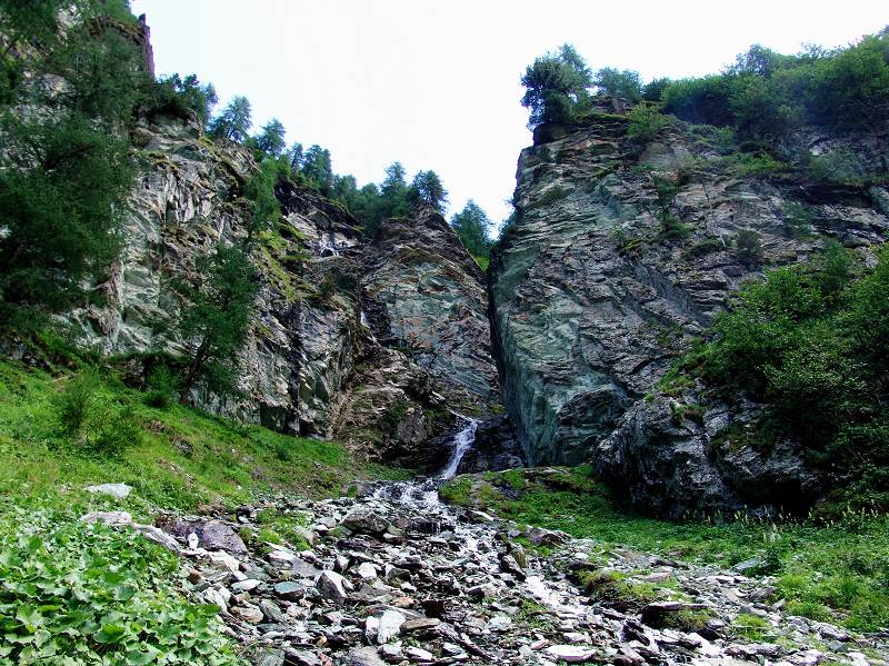
The difference between Steig and Steigspuren is rather qualitative than quantitative, I’d say. For a flash, I thought, picture above might tell consumers quite a lot of what an OSM highway=path highway=bootprints can look like?

Note, that the official map uses Steigspuren in a much broader meaning, a bit like, anything that can be mistaken for a game trail perhaps? I do not know for sure.

I am fairly certain, that this would pass OSM-Carto muster. If in case the tagging would depend on something clearly observable from the ground. The rendering suggestion was literally taken from OSM-Carto issue tracker.

This is something I learned since I became politician. It is not something that is guiding my own mapping efforts.

For better or worse, lots of ideas migrate from openstreetmap-carto issues to pull requests and then languish. The more interesting question is how well other renderers would receive this tag, particularly less complex styles focused on outdoor recreation.

1 Like

I’d be quite interested in how renderers would receive putting image above as the boiler plate image for highway=path, particularly less complex styles focused bike rental, pizza_delivery or some such, that still offer pedestrian routing, or ones that show 3D of OSM data – After all, it shows a highway=path with trail_visibility=good :slight_smile:

If you know of a pizza parlor that delivers to the backcountry, I’ll want to keep it in mind the next time I’m out there. Backpacking in style!

The “Steigspuren” only appeared in our “governmental” data during the Covid pandemic. Previously the editor backdrops only contained what they today sell or OGD for their routing consumers, e.g. most “official” public_transport+foot/bike mixed routers. I often see delivery bikers aimlessly in urban areas, but this is another topic. So yes, chances should be not so bad in backcountry, when service disponents use OSM data.

Meanwhile, having watched some videos on youtube on the topic of scrambling, by the BMC or private persons, path indeed seems to include what we here call bootprints, i.e. traces of people walking, or maybe even, the mere possibility to traverse some terrain.

I conclude, highway=path is the perfect tool to map such. Inclined to update the picture in the Wiki - Any law that says, the picture should show what is most commonly mapped with a certain tag? I don’t think, the picture as of now meets that criterion, so, gonna get a go :slight_smile: