I think there is something to “unmarked” routes created and generally known by locals and others familiar with the area. We could place a node at each of natural landmarks used to create the bounds of the otherwise unmarked route. These can be considered to virtual route marker.
(veering slightly offtopic from “pathless” routes into “verifiability if no signage”)
Unmarked trails will usually fail the verifiability test and on that basis should not be in OSM. The tricky bit is where do you draw the line? Often trails are “well known” (similar to what @IanH suggests) even without on the ground markings.
In the UK, the Lyke Wake Walk and Wainright’s Coast to Coast were historically largely unsigned. I’ve added guideposts et al to both OSM relations from survey and as you can see, they’re now very well signposted. Another “borderline” one is this one. There is some signage, but not much. Should it be in OSM?
As someone recalled me recently, most state borders in Europe are not verifiable on the ground but only from legitimate sources. In France we have chosen the same approach for routes because some do not have their own signing. The tricky part of course is to define what a legitimate source is, but it’s manageable.
2 Likes
I think most map users will appreciate being shown such “paths”, so I’m in favour of showing them.
This is pretty close to what I was envisioning. Say a few points that would illustrate how you would describe a trail in a brief spoken description like “drop down from the pass to the little pond, then keep to your right once you hit the pond and drop down a series of ledges until you reach a set of cliffs where you can find a crack down near a meadow” - you’re not going to be telling them GPS coordinates for a node every 5 meters, but a note for the pass, the pond, then the crack through the cliff band near the bottom etc.
There could be a use case for tighter / more accurate ways in some cases.
If I’m reading this correctly you’re asking if something with trail_visbility=intermediate, trailblazed=no, and no guideposts at intersections should be a path to be included in OSM?
Isn’t this one of the points of the informal tag? If there is a desire path created from human traffic that is visible it doesn’t need signs or guideposts to have ground truth.
An interesting consideration for this thread from the bottom of the verifiability page.
We have a general rule that says stuff must be verifiable. General rule doesn’t mean “no-exception-made set in stone”, but it means: You need a very good reason for mapping something not verifiable. Such a reason could be that the data is of a relatively high usefulness to relatively many people, or that the data is useful for mappers in their work.
I think in regards to guidebooks, something where the author “creates” a new route - like Skurka or Roper probably shouldn’t be included, as that would undermine their work (or at the very least it should be very vague, like a start/end). If a guidebook like Secor which has brief descriptions of hundreds of passes and peaks, then it seems fine to include things from it as they (with a few exceptions) existed before that and the guidebook is documenting them vs creating them a commercial product and/or service to the community.
(just to clear this one up**) no, not really. I’ll not use the word “trail” in what follows because of the obvious double meanings that has.
This route was created by a person who wrote a book about it. Most of the OSM ways it goes over are obvious paths (mostly trail-visibility=good or better). None of the paths are informal=yes in the OSM sense. Other routes over the same OSM ways are very well signposted - the ways aren’t tagged as such in OSM, but if they were you’d tag each way as trailblazed=yes or similar. Similarly, the other routes aren’t tagged in OSM, but if they were you could perhaps tag each route as trailblazed=yes, although for the avoidance of doubt https://taginfo.openstreetmap.org/keys/trailblazed#overview suggests most usage of that tag is on ways (which the discussion above has concentrated on).
The relation I was asking about has only a few guideposts - not enough to follow the whole route. There isn’t really a trailblazed value in use for that. If there were no signposts for the route at all then it probably wouldn’t be verifiable and probably wouldn’t belong in OSM at all. There are however a few signposts.Hence why I asked the question - how to tag routes that are signed a bit, but not much?
** logically this may be something that belongs in another thread, of course.
Ok, that makes more sense looking at it closely. I came across something similar in another mapping program recently, and created a new thread for the topic.
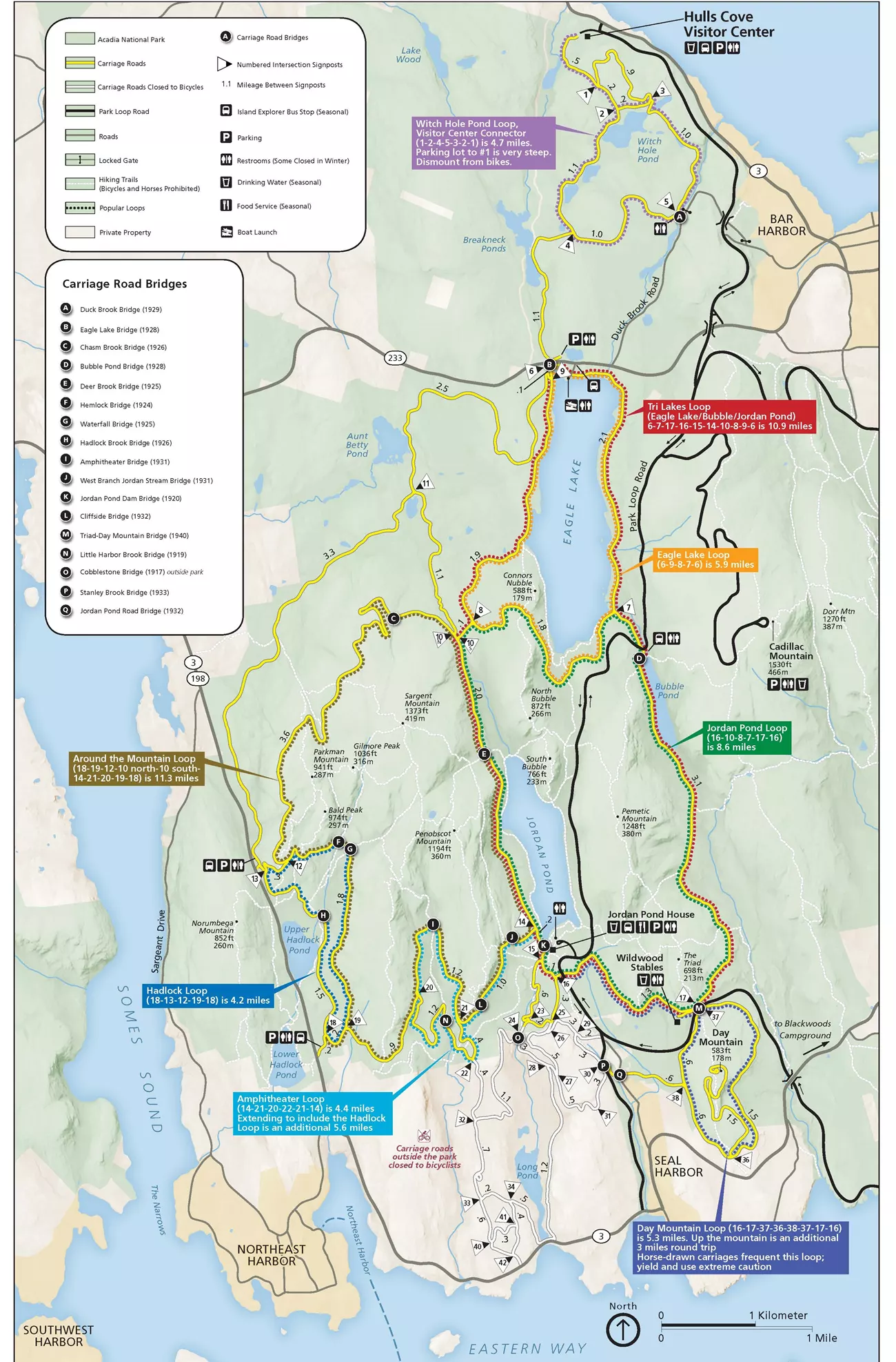
On the note of node_networks, in the US Trails Working Group (which I am in no way a key part of) someone brought up this system of mixed use frontcountry trails in New Mexico, which made me think of Acadia National Park’s carriage road system. So node_network’s do exist in the US too!
1 Like
If the labeled nodes are actually found at the junctions, AND point to one another by their labels, these are true node networks as defined in OSM. If the numbers are only a help for finding itineraries on the paper map, they are not. Have these networks been mapped as node networks?
Acadia
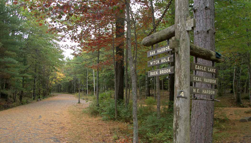
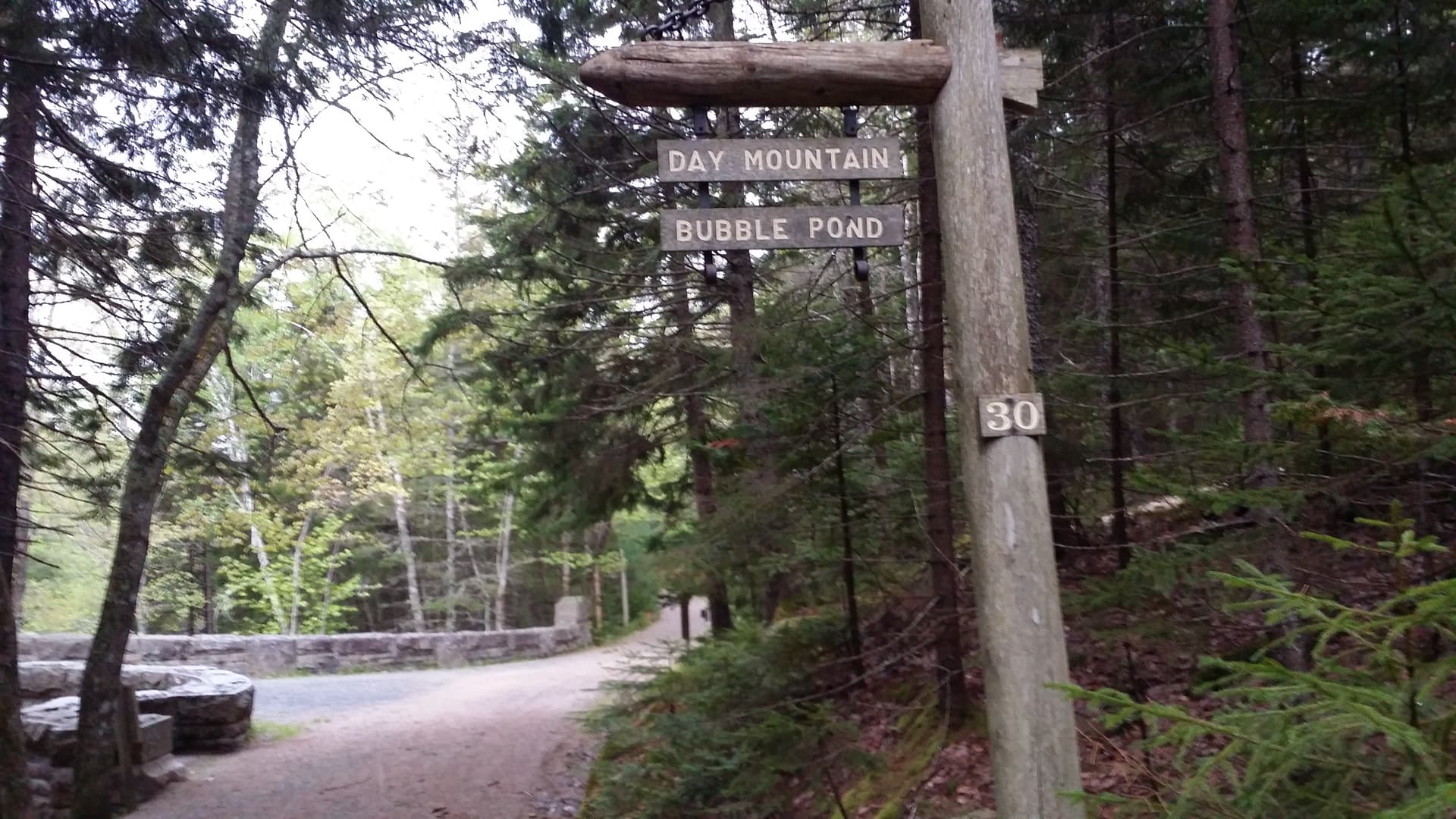
Acadia National Park has numbers on their signposts.
Here’s some images from junctions (they also have general “this thing is over here” typical US junction signs for the US public). Perhaps that makes them a hybrid network? I’m not an expert on node_network concept and only learned of it recently as part of this discussion and similar ones elsewhere. ![]()
Here is the area on OSM: OpenStreetMap
La Tierra
It appears the one in New Mexico does as well, and points to the actual numbers. This showed up in a google images search:
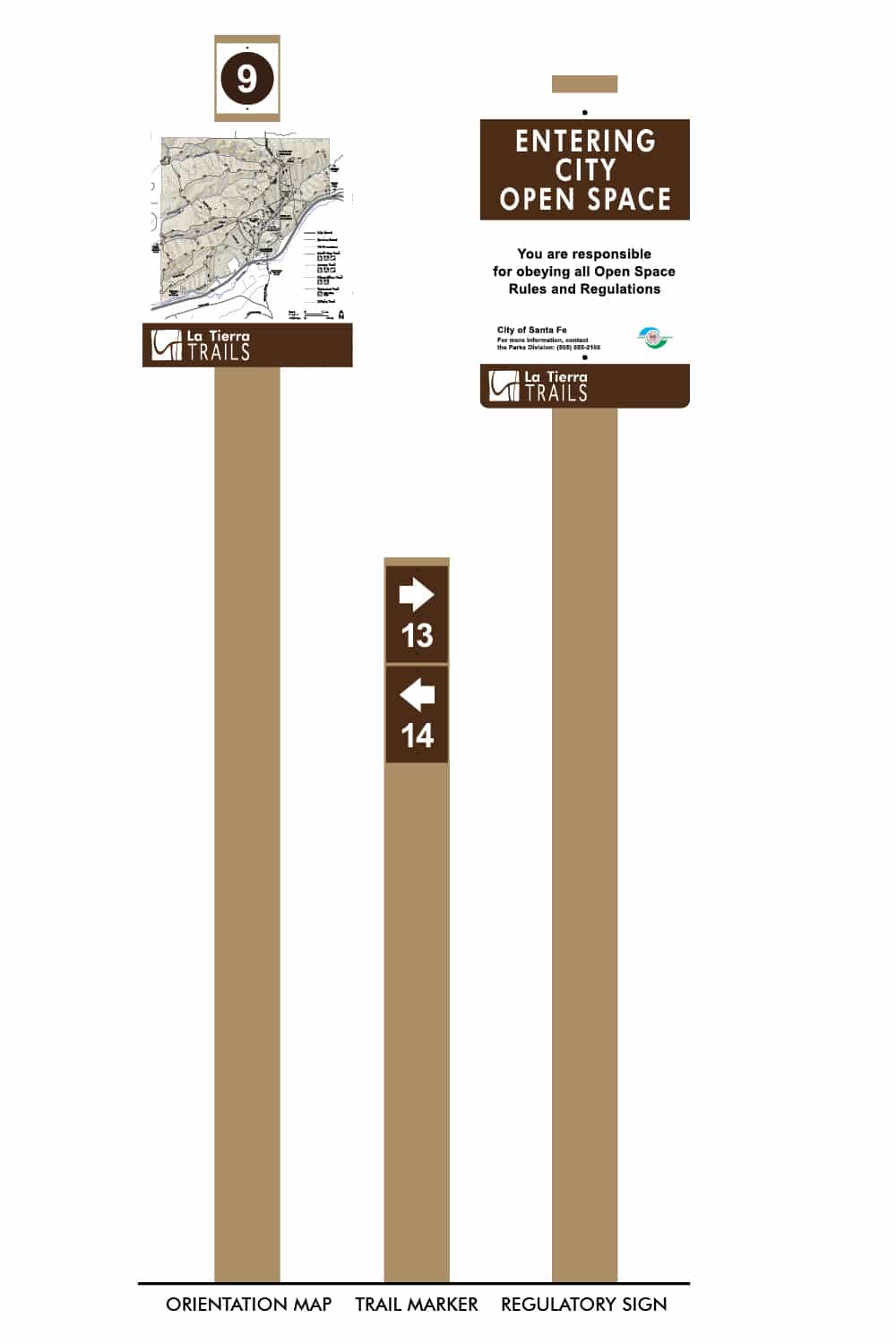
Their website map has the following:
Here it is on OSM la tierra trails | OpenStreetMap
Acadia: not a Node Network, because the numbered poles have no pointers to adjacent numbered poles.
La Tierra: definitely a Node Network! With nothing more than a number strip you can follow your planned itinerary. This one could be mapped as a Node Network. Knooppuntnet Planner can then be used by recreants to plan their trip, then print the number strip or transfer the gpx to an app or device for convenient voice navigation.
Knooppuntnet Analyser can check and monitor the integrity of the network.
Note that you don’t have to know the exact geometry of the connections between the nodes. You will find the arrows on your way. Suppose there are no arrows, you would have to make your own way to the next Node. For that to work, you’ll need to be able to see the next Node.
PS My suggestion to a few route operators was to have a large anchored balloon, coloured like the route symbol, floating over the Node location. Think giant flying Pokéball. So far, noone has done that, can you believe it?
1 Like
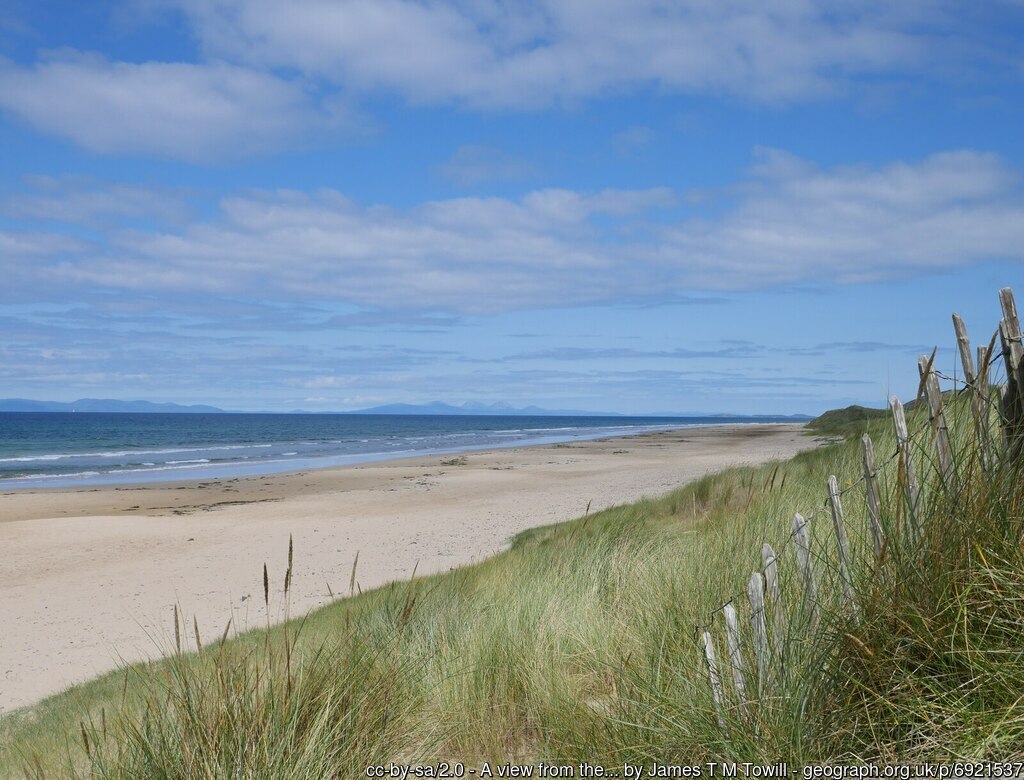
Thanks to another thread, I inadvertently found another example which is defined as a Scottish core path & which I have walked many times. This is a famous beach just N of the Mull of Kintyre (with views up towards Paul McCartney’s farmhouse at Tangy). The beach is around 4 miles long and makes a pleasant walk in all but the worst weather. This picture from Geograph shows the views out to Islay and Jura.
The beach is popular with locals and is accessible from the N (Westport with car park) or from Machrihanish village at the S, although the most heavily used parts are within 200 m of either end. Machrihanish is a well-known surfing destination and surfing clubs may drive on to the beach S of Machirhanish Water. The best walking is just below the high tide line as the sand is more compact. Above the tidal zone the sand is loose and walking demands more effort. Continuous wind ensure that even above the tidal zone footprints get erased quickly.
For some reason the beach has never been incorporated into the local long-distance footpath and was never marked as a path during the times I visited frequently.
1 Like