I proposed a mass edit to remove emergency=ses_station and apply emergency=disaster_response to objects of the Australian SES’es. Please leave an approving or opposing comment in the seperate thread:
Independently from my proposed mass edit to change emergency=ses_station to emergency=disaster_response I would like to move forward with a general clean up and addition of the Australian SES-facilitys. I found this database from the Digital Atlas of Australia:
It includes nearly 4500 emergency facilitys in Australia as seen as blue dots on this map:
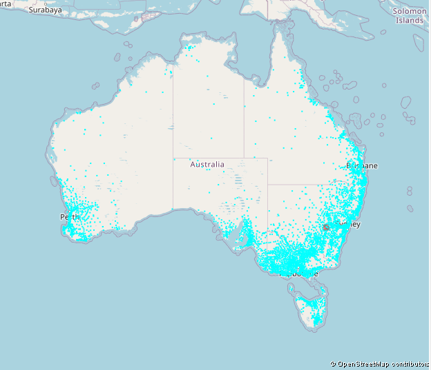
If I get it right it is a mixture of SES-stations and fire stations.
The problem I see: It is licensed under Creative Commons Attribution 4.0 whitch is not completly compatible to OSM’s ODbL. In the wiki there is an Australian Import Catalogue listing imports under CC-BY. Is there any general agreement that we can use data from the Australian Government in OSM?
This is the list of our currently approved sources: Australian Data Sources - OpenStreetMap Wiki, which includes https://www.emsina.org/emergency-management-facilty-data, which should be OK to import?
Appears no-one has ever actually done it all though.
The data is from 2018, so It might need some checking to make sure that it is still up to date enough to import.
I checked that. There is this email talk between Andrew, an OSM contributor and Elizabeth from Geoscience Australia, see here. It is a lot of text but if I get it right the improtant content is:
Andrew: We’re very interested in using Geoscience Australia’s CC BY 4.0 licensed data to
improve OpenStreetMap. In order to facilitate this, we need to confirm with you that
Geoscience Australia has no objections.
Elizabeth: Geoscience Australia gives you permission to use the data under ODBL.
So we have permission to use Geoscience Australia’s data.
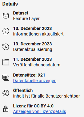
The Digital Atlas of Australia says it is ![]() . Does that mean we have permission to use any data from the Digital Atlas of Australia?
. Does that mean we have permission to use any data from the Digital Atlas of Australia?
Where did you take that from? It says it is from December 2023 so pretty much up to date.
It’s in the Lineage Statement. What they did in 2023 was match the locations with G-NAF.
Thank you for the explanation. Now I found it.

How often do the SES-stations move? The data set is described as:
![]()
Modifiing the data “as needed” implies that they update the data set if a station moves. Is it plausibel that no SES-station moved, closed or opened in the past 6 years? Can we consider this data up to date?
Not “frequently”
Possible, but I would think that yes, a (very?) small number could have
To be honest, with ~4500 stations of various sorts listed, I’d be quite surprised if as many as 10-20 of them were wrong, so yes, I’d personally say it was as up to date as any database.
No it doesn’t. What you have to remember with a lot of the GA datasets, is that they get a dump of data from the states at some point and then it will not be updated until the process is done again. These datasets are a one shot deal.
A quick check of NSW DCS vs this dataset finds that it has 325 SES facilities listed and this dataset 256. A check of the last date modified shows that of the 325 at least 100 have been modified since 2018.
Wow!
That’s a lot of changes in 5 years!
I checked the state databases we have access to. NSW and VIC seem to be kept up to date. All I could find for SA was from 2014 and the TAS dataset is from 2017.
I do not know the systematics of Geoscience Australia. What you descibe sounds very different from “Modification frequency: As needed”. It sounds more like “Modification frequency: only if someone gives us a new data set”.
Can you explain this in more detail? Where can I find the “NSW DCS”? What was modified?
Can you give us some links of these data sources? Are they licensed accordingly? If we have seperate databases for the states that are more up to data than the governmental one we could use them seperatly.
NSW: https://datasets.seed.nsw.gov.au/dataset/nsw-points-of-interest-poi
VIC: Vicmap Features of Interest - Dataset - Victorian Government Data Directory
SA: Emergency Services - Dataset - data.sa.gov.au
TAS: GeoNetwork - The portal to spatial data and information
Not sure if this is useful but I found this data source for QLD:
It’s licenced as CC BY 4.0 but also “open data”.
Edit: Ah, I see this source (and CC BY 4.0) is already being discussed ![]()
1 Like
I am now trying to download the data for longer than this should take. For VIC I reached some page asking me to set up an account to “buy” the data set for 0$. Do I realy need to create an account for that? For NSW I was not even able to find any download link. Eighter the pages are much more complicated than necessary or I am just to dumb to use them. Help.
For Tasmania there is also a more recent dataset but no download link
This data may also be included already in the Points of Interest dataset available at the LIST OpenData portal
I’m a volunteer in the ACT SES*, and just in the last week there’s been some moves of SES stations - the Gungahlin unit has had to move out during renovations (https://the-riotact.com/gungahlins-police-fire-and-ambulance-station-closed-after-contaminants-found/748840), and there are plans for the Majura and Gungahlin units to move into another location in the next 18 months. So, these things can and do happen, though I would guess these changes are far more likely in cities than rural stations.
Based on the definition of emergency=disaster_response, it seems like the relevant tag to use for all seven units in the ACT - 6 operational (Belconnen, Gungahlin, Majura, Woden, Rivers & Tuggeranong), and 1 support/communications/incident management unit (Pialligo).
* I don’t represent anyone and shouldn’t be considered an authority on anything, etc. etc.
1 Like
It seems to be difficult to actually use/download the “open” data from the Australian government.
Welcome @Axman6 in the forum. If I understand your link right it means that this station moved recently:
Where exactly did it move?
We already have 75 potential SES-stations in our database that do not have emergency=disaster_response, amenity=fire_station or office=governement.
Some of them are already tagged correctly but most of them are probably missing the feature-tag.
It would still be nice to get access to an up to date and open database of all stations to update our data. Unfortunatly I cant find one that I can actually download.
The quest to find a usable source for some kind of mass import/update seems to be difficult. I just created a MapRoulett-Challenge to check some of the SES-objects that have a name=* but do not have a main tag like emergency=disaster_response or office=government. For now I set it to not discoverable because I am not sure if my decribtion is understandable. It would be nice if someone could check this and give me some feedback or maybe even correct some of the errors.