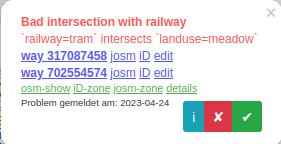
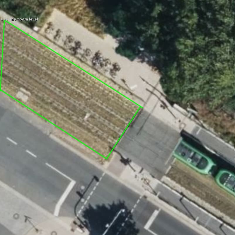
Today, osmose started to complain that the railway tracks for the tram here are mapped over a landuse=meadow¹:
Now, you could complain that “osmose sucks” and I should “ignore it” and that “landuse=meadow is wrong for the grass on the track bed anyway”, but the question is: what would be the proper way to tag this? Is omose right, or should I report this as a bug?
[1] I did not map it like this, I’m just dealing with the fallout
The grass/hay is actually cut twice a year and used to create fertilizer. So while I actually prefer landuse=grass over landuse=meadow, I don’t think it’s completely wrong. But I’m not sure Osmose is complaining about the meadow and wouldn’t complain about grass, but I can give it a try. Hm… or look at the sourcecode.
At least historically landuse was understood as a generalized mapping of the dominant use of a larger area including the objects that would generally be expected to be present in such an area.
For example landuse=residential should include residential buildings, streets and other related elements. Cutting out say buildings from a residential area, a practice that I’ve seen now and then, would seem to be nonsensical and run counter to what landuse mapping is for, but doing the same for a garden area mapped on top of the residential area would be just fine (if you want to go in to such a level of detail).
In the case in question I can argue both ways, and my comments from Osmose drives me mad apply equally.
At least historically landuse was understood as a generalized mapping of the dominant use of a larger area including the objects that would generally be expected to be present in such an area.
For example landuse=residential should include residential buildings, streets and other related elements.
I would say no, streets should never be included in residential landuse, and yes, it was done initially in a first very rough attempt to start mapping landuse. Similarly, motorways also had been mapped as a single highway with oneway=no in the early days, because we were in the beginning and everything was missing, so it was ok to not be perfect in the first iterations.
Cutting out say buildings from a residential area, a practice that I’ve seen now and then, would seem to be nonsensical and run counter to what landuse mapping is for, but doing the same for a garden area mapped on top of the residential area would be just fine (if you want to go in to such a level of detail).
IMHO both would be nonsensical, because a garden just like a house, is a place where people live. Streets aren’t.
I have used landuse=railway for tram track bed in past (but included also where they intersect with road and would include also passenger platforms and shelters)
Sound good in theory but falls short when you have mixed uses. The solution to this is to map the functional usage of combined plots of land, like how it would be zoned. Then you can have farmyard, residential, industrial, commercial, construction, and retail all in one area:
This is the 08/15 example of landuse mapping we have in Switzerland. Only that quite some Mappers glue the landuse to the roads – just because. They don’t like that the road plots “are blank inbetween”. Well most roads are dedicated plots, and should be either area:highway=* or a new landuse=highway/road, but they are not any other landuse than for the road as such.
That’s another topical problem that some Mappers seem to confuse, “nice rendering” with the factual OTG situation, that a road may take up to 24 Meters, that are just “road” and not anything like farmland, grass or other…