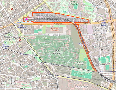
I’ve remapped Budapest-Keleti railway=station as an area. Now it looks like this:
The label is rendered far away from the station building marked with the purple dot.
I’m sorry to bring this up again, but I asked (HU) fellow mappers at a recent OSM Hungary Meetup if they agreed with this mapping method, and if they would be willing to wait for more railway operating sites being mapped as areas—until this problem is fixed in the renderer.
@BáthoryPéter suggested that in these cases—where the station label would be rendered far away from the public areas of the station—, we could go back to using a railway=station node, and map the station area with a separate landuse=railway area, which has an additional tag that could be chosen by agreement. This additional tag could distinguish it from other landuse=railway areas that do not mark the boundary of a railway operating site. This way the renderer would be “forced” to render the name of the station in the correct place.
What do you think of this idea?
It’s good to know that if we decided to map some stations this way, we would make it harder to connect the station with its perimeter (which is actually why I started this discussion). For example, we would lose the ability to Overpass query all objects of railway operating sites where the area of landuse=railway is mapped as a multipolygon relation. This is because the API can’t convert multipolygon relations that do not have a name=* tag to areas. (See this example.) So they couldn’t be written to sets and passed as input to another line in the query (like here) in order to get all elements within the station boundaries.
