Ha ha - but we all know how to drive down here…not like those “northern islanders” ![]()
![]()
I have also driven the Barry Way (with my Tvan behind me!) and I agree its way better than track! Unclassified at minimum…
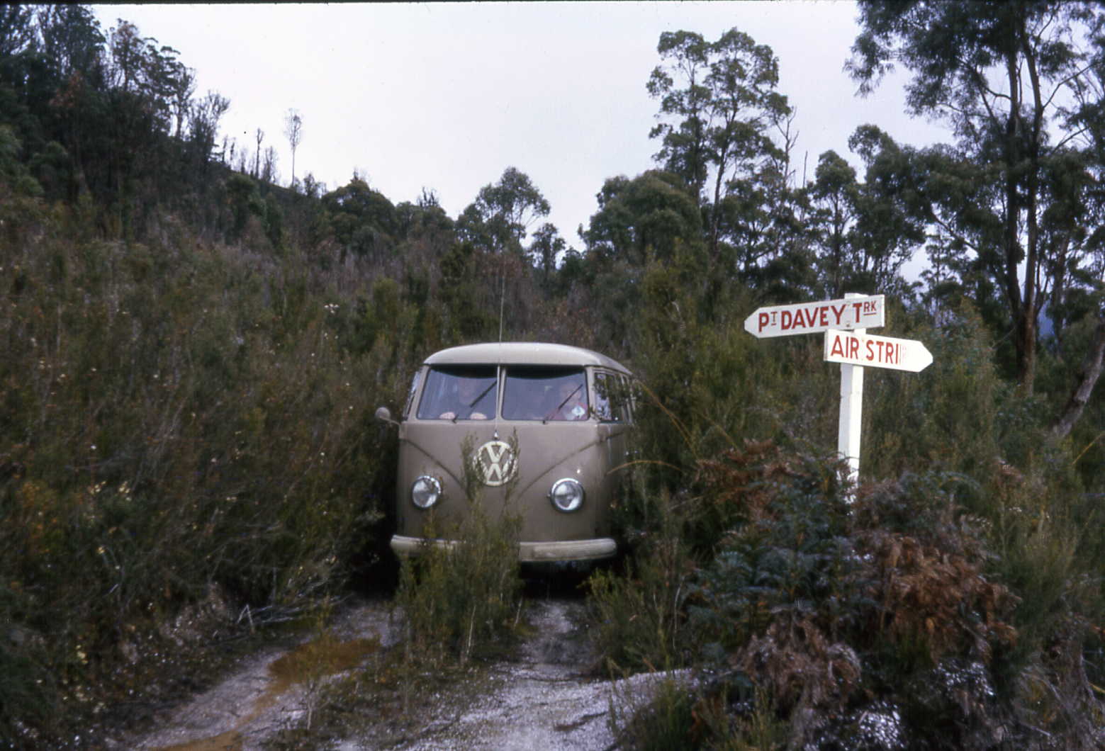
This is a real track… ![]()
![]()
Ha ha - but we all know how to drive down here…not like those “northern islanders” ![]()
![]()
I have also driven the Barry Way (with my Tvan behind me!) and I agree its way better than track! Unclassified at minimum…
This is a real track… ![]()
![]()
Have you driven it at any other times of year?
While you say OSM captures what’s on the ground, you continually reference to formal designations to justify keeping it as a secondary route. I provided information that speaks to the actual conditions of the road, including and beyond my own experience, which was used to submit the edit.
My changeset was posted 6 months ago in the dead of winter, which is when we frequent this part of Victoria and similar parts of NSW. It rains a fair bit at other times of year which is when I experience it. We also used essentially every route from the south and north to access the major tourist attractions from Melbourne multiple times. Only this route required major edits in line with ability to use it, and all the available local recommendations for how to access our destinations and return safely (including the weather conditions when I was there). I have no problem with the Great Alpine Rd being a primary with a B designation even though it’s 1 lane but sealed in many parts (and we almost got slammed by a truck riding the center line) and I made no edits to that road.
Trip advisor was used to bring you additional viewpoints beyond my personal experience and beyond the relatively small AU OSM community. Others on the changeset also told you this road doesn’t rate secondary, nor even tertiary, but most with experience of it aren’t here to weigh in unless we wait another 6 months or more for somebody with experience of it to show up and comment. Therefore, I linked perspectives (including 5 star ratings from people who liked it) which are also on many other forums, as well as local recommendations from our frequent visits, as well as my personal experience with other drivers who were stuck with thousands in repairs from driving it in a stock standard car capable of safely passing over every other speed hump and C route in victoria, save this road.
Of all the roads in Victoria, and in this area in particular, this is the route that requires changes you seem unwilling to accept.
I agree it’s higher than track with other that have posted and already submitted those updates. However I don’t agree it’s secondary just because it has a formal C designation.
We have established it’s higher than track. Can you provide any perspective on what it should be as secondary, tertiary, or unclassified, as Steve came here for other first hand opinions?
In terms of the function it serves I would still say secondary but I spend a lot of time on these types of roads so they dont bother me. Its also full of campsites, tourist points, picnic sites etc.
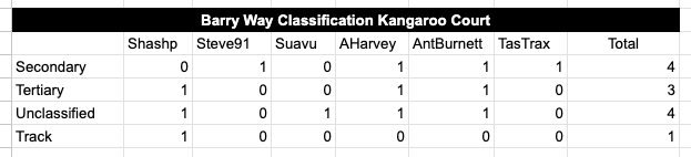
steve91 says secondary
tastrax says secondary
myself and AntBurnett say anything > track
shashp says track
Based on this we should tag it secondary.
@shashp When assessing a road’s suitability to drive on based on your vehicle type and experience, don’t inspect the highway=* tag, instead look at smoothness=, surface=, tracktype=* (which I’m happy to see used on a highway>track), 4wd_only=, width= as per Australian Tagging Guidelines/Roads - OpenStreetMap Wiki
i already attempted to amend my edit and said anything less than secondary. Swavu also said on the changeset it doesn’t rate secondary nor tertiary. but i’ll agree to leave it and use my personal experience to know which routes to avoid.
not that i expect it to change anything but other secondary roads in this area are sealed two lane roads. this one is not. it doesn’t deserve the same heirarchy. it’s up to other mappers now.
Hi @aharvey , in the spirit of progress here, I’m hoping to learn how these classification elections are meant to work and be decided at least for AU regional roads. Is there a sub-objective to not change classifications once set in OSM or to flatten the hierarchy as much as is tolerable?
By my count, there are as many users open to accepting a classification change as to keeping status quo. To me, this is far more indicative of a problem in OSM’s highway= hierarchy than a solution if secondary and unclassified could be equally applicable:
Is there some deciding preference for it to either remain unchanged, or be flattened in the hierarchy, or elevated compared to other improved roads in this region? Those goals all seem counter to the purpose/progress of open data platforms. It feels like there’s an unspoken threat of wholesale, country-wide classification changes (or at least across Tassy) if one road in regional Vic is allowed to be updated.
To my original participation on this thread, is there some advantage to elevate classification tags that would offset a confusing expectation for consumers of OSM’s data?
Some here have suggested that road maintenance budgets by local councils would be impacted by OSM’s upgrade/downgrade to track. I’ve never come across any guidance from any Vic council in suburbia that budgets are set by OSM’s classification tags, but rather other official roadway designations, usage and planning studies undertaken. TheSwavu’s comments on my changeset (one of this way’s original mappers) echo notes from others at the start of this thread wrt Monaro/Kings Hwy regarding population centers and links to primary road networks
Comment from TheSwavu 8 days ago
This isn't really a secondary road. It doesn't link any population centres to the primary network. One of its features is that there's nothing on it.

I don't think it would even rate tertiary.

But this isn't the place to discuss this. I'd suggest on the forum
My change wasn’t meant as an attack on the local mappers who have poured their soul into mapping this region, but as an improvement for the many of us roadusers that have been routed there unexpectedly, in street legal/roadworthy vehicles to find this way unfit for purpose. My purpose of passing through the region to visit the ski resorts multiple times each winter shouldn’t disqualify my experience from the summertime users who visit to camp in the wilderness. Without comparing snorkel sizes and tread depths, road classifications do set expectations of use and suitability and these roads otherwise haven’t been tagged with low level details like smoothness and track type. Clearly, many drivers including myself have found the stated purpose of passing through this way as unacceptable/unpassable whether it be to collect medical supplies or otherwise access the area on the other side. I may have overlooked the economic boost it promises to local business when accidental tourism leads to safety issues and vehicle damage, but that hardly seems a rationale to keep open data intentionally wrong.
Perhaps there’s some insights in common meanings of the names of these roads intending to be conveyed:
Snowy River Highway / Monaro Highway - appear to deserve a raised hierarchy, and the OP consensus seemed to be ‘primary’, not ‘trunk’, for these B roads given the AU (and certainly international) guidelines.
Kosciuszko Road is a 2 lane (more in some places), fully sealed, state-managed road for closures and 2WD restrictions with wide, paved areas and signage designed to fit chains, not a B road unless I’m mistaken. Is this also classed as primary? Why do we call the others “highway” and this “road” if not to set a distinction in their hierarchy/purpose and user expectation? Or is OSM’s approach to class these both the same? photos of it online (which fit to my experiences of it in varying weather conditions from open and clear for all vehicles to all vehicles including 4x4 requiring chains) seems to have a striking resemblance to the secondary roads in the Aussie guidelines prev linked above, as seen below, which also fits TransportVic’s description of C roads as linked above (despite the Tassy drivers’ typical experiences):
Also note: the qualifying characteristics isn’t just the presence of shoulders nor it’s smoothness to pick apart my prev posts, but it’s overall hierarchy for many different uses and many different users in the region setting expectations, of which I am a regular user, albeit seasonally.
Barry Way aka Lower Snowy Drive is everything previously documented about it, by Steve91’s own words on the changeset ‘confronting’ for unfamiliar but licensed drivers capable of using any other secondary throughways in the country and internationally (save maybe Tassy based on recent reports from this thread). No other secondary road I’ve used in VIC/NSW or other countries internationally so far is ‘confronting’ in my view, with TasTrax also noting it requires spending enough time on roads of similar quality to agree it fits secondary classification as a link to rural campsites and lookouts, yet not even worth officially naming it as a road. Why is it called a “way” or “drive” if it rates a similar hierarchy as the other sealed roads above? It’s now been tagged as track type = grade2, when National Parks NSW describes it as a way for visiting nature and campgrounds, not as a vital route to ferry medical supplies for the local population centers, noting it is ‘boggy’ after rains, unsealed, steep, and narrow on the offical page (also noting the only sealed sections are on the NSW side)
It seems the initial approach prompting this thread for the OP was to promote B23 and B72 to ‘trunk’ roads given the clear hierarchical distinction from other ‘big’ roads in the area if they are designated primary and secondary already by comparison to the dirt paths leading here.
As this thread stands, mappers can neither elevate bigger/better highways, nor downgrade the smaller dirt ways, and the community seems to expect consumers to research outdated OSM tags for smoothness and track type before taking any road trip when in-built navigation systems that rely on this data believe these roads to be otherwise equivalent and re-route to it mid-trip.
The data here is broken, and 2 members of the community seem to be standing in the way of users fixing it. The process in this thread hardly seems appropriate.
This topic is pretty important to me as I feel the lack of proper map data was mentioned in this news article in Tasmania road incident recently. I’m hoping this detailed post can help move past the obstacles of improving the data, as it seems to continue to come up in other threads.
In regard to the recent Tassie accident (and death of the travellers) the road in question is a Minor/Unclassified in OSM. That was also my second suggestion for the Barry Way. The Tassie road in question certainly looks and feels much more like a “Forestry Road” than a tourist road with campsites etc and is a major thoroughfare for logging in the area with little other infrastructure. They are well travelled by locals and its hard to see how the tourists may have been directed onto it (maybe by spurious GPS directions).
PS - we would all be guessing as to how data consumers use the data tags in OSM
Thanks for your update. The bridge itself in Tassy that was noted in the news articles, which is marked in OSM as paved with no other low level details like smoothness, or that it’s only a single lane bridge and the entire road linking to it is still marked as a tertiary road in OSM as of today. Genuinely curious how is it that you’re seeing it as as minor/unclassified in OSM, unless the site of the actual incident is not well known or the web editor shows different data? Google Maps which was specifically called out in the news as sending tourists on these roads has already been updated to fix both problematic areas as far as I can tell while a select few in this community continue to belabour the idea that smoothness details will somehow resolve the problems with the classifications for secondary and unclassified being equally applicable.
Also this thread started with questions about the actual highways in the area being elevated so there are members of the community trying on both sides to improve the classifications here to no avail.
For barry way in particular I’ve put in a bunch of information that talks about the priority and importance of the adjoining roads that connect this area, in addition to the visiting populations ability to use them. Roads are prioritised to be cleared by their importance to the area and the visitors they get. Yes, it’s true for the population of 6 in suggan buggan (according to the last census I could find) this is the only roadway I can see, but I hardly see how that justifies it as continuing to be marked as a secondary roadway for anyone other than those that must use it.
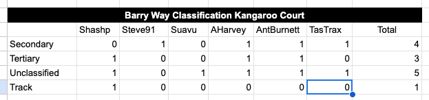
With Tastrax updated post it seems Unclassified should be applied for the classification of Barry way, if this form of voting is still the only official method OSM accepts for how to improve the incorrect classifications of these roads.
There are two Tebrakunna Roads in the area - one is a C road (tertiary through road) and the other Unclassified (in forestry areas). The accident was likely on the tertiary road. Locals are used to driving on these roads - tourists less so. The bridge is actually concrete surfaced and a very common type in that area and many others.
Likely the bridge involved in the accident
I am not aware of how they were routed to the area but there are a network of roads in the area and again, well used by locals.