Yes absolutely. I don’t mean to suggest actually inventing a new tag. I was just wishing that a different tag had been chosen years ago. One that might not have been so prone to misuse. “Razed” means the thing in question has been completely demolished. We can certainly try to document that the meaning of railway=razed in OSM is slightly different and means “mostly demolished, but with some terrain features still remaining”. If railway=dismantled means the same thing, I find that a clearer word choice. “Dismantled” doesn’t carry the same connotation of complete obliteration that “razed” does.
1 Like
Yes, it has been widely interpreted as meaning the same thing, and was widely used (at least in the UK) before razed became prevalent. Obviously that still leaves the question of “what deserves that tag” [waves vaguely at the preceding 120 posts].
2 Likes
There are a great many layers, reasons, histories and tagging associated with the present and the past of these (rail) taggings. It’s like a snarly tangle that must be unraveled.
I think it is fair to start by not wholesale deleting of tags. There are reasons for why those tags evolved and at the same time there are those who find them offensive, confusing or “in their way” (of interpreting other, likely rail, though not necessarily rail, data). There continues to be a harmonious middle ground to migrating them to consensus.
I have found (in my career, life, experience, with some wisdom and growth along the way, hopefully…) that taking a snapshot of “what we have” can be helpful, provided many agree that in doing so, we see and plan how we might best accommodate downstream users of our data, parsers, ORM, Carto and many others. A snapshot will allow us to say (some of) “these (taggings) are clearly old / broken / misapplied / poorly used today…” enough to throw some taggings into the “delete” bin, provided we accommodate these with other tagging. Or, we might choose to preserve these tags, but discourage further future tagging of them with a (proposed or actual) schema of rail tagging. This sort of evolution would eventually emerge on its own, I’m pretty sure, but I’m simply sharpening up the focus on how we might take a deliberate look at it and streamline it into a syntax / semantic scheme that we all agree upon. That really is the goal here, even if nobody has stated it.
Now that it is stated, let’s do it. We should start by saying whether we are OK with simultaneously having messy (rail) tagging in OSM and somewhat-cleaner (rail) tagging in OHM. Personally, I’m OK with that. We might migrate to something “tighter” in the future, sure. It’s nailing up some taginfo data and “what we mean by that” turning into consensus, then a path forward to “how we’d like to continue doing this, only better.”
See, that’s easy to say, and kind of hard to do. Yet, I think we can.
1 Like
Alternatively couldn’t we move to lifecycle tagging for these objects (currently they are classical troll tags). And maybe a light weight way of mapping “historic” railway routes with relations that allow recreating rough geometries of the missing pieces and will use geometries of what is actually still visible (say an embankment and similar).
PS: this thread came very handy yesterday in an interview with a research group of an example of OSM processes -not- working :-).
3 Likes
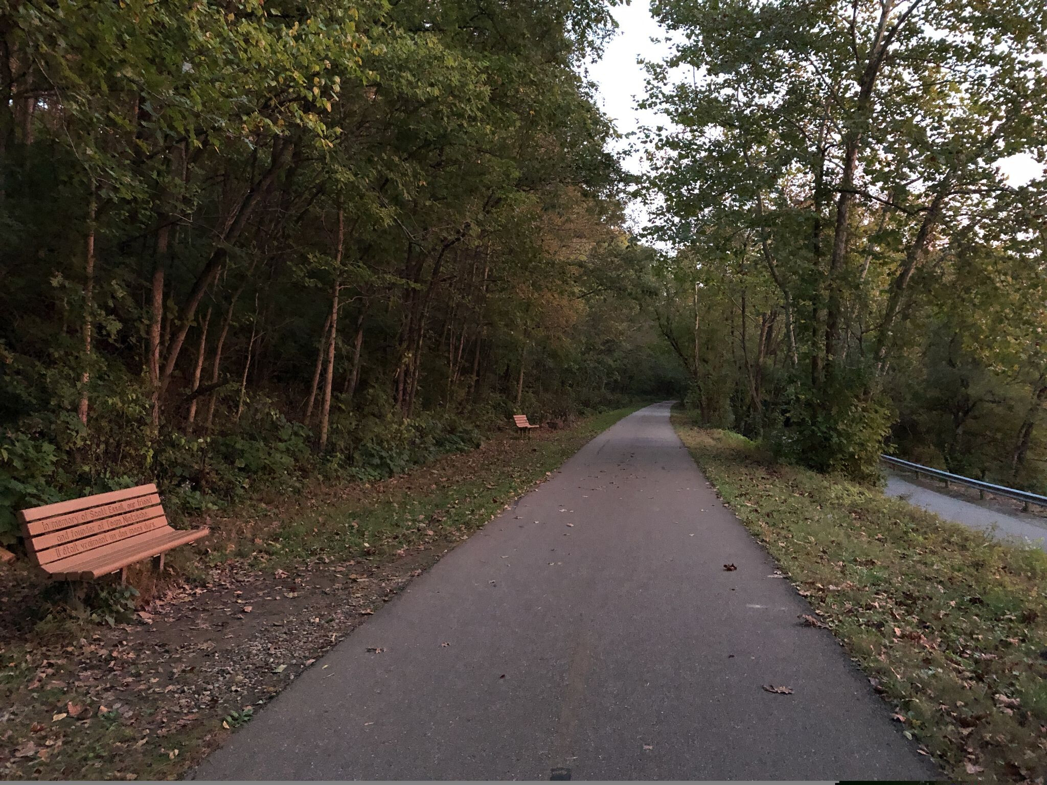
I grew up in a town that’s mainly notable for the rail trail that passes through it.[1] When I first started mapping in OSM, Google Maps was still showing the trail as an active railway, more than 40 years after it closed and converted into a bike trail (technically a shared use path for pedestrians, cyclists, and horseback riders alike). I was proud to make OSM the first online map to ever acknowledge the bike trail.[2]
The town made some effort to remind trail users of its history, preserving an obsolete railroad crossing sign and a small iron bridge over a creek. But this amounted to only 125 feet out of a 78-mile-long trail (38 m out of 125 km). Otherwise, you’d only know it’s a rail trail from its level grade and gentle curves. In America, we don’t normally build such usable cycling infrastructure on purpose. But one could alternatively chalk it up to the quiet, meandering river it follows.
When I first turned the TIGER-imported railroad track into a bike trail in 2008, editors and aerial imagery layers didn’t support the degree of micromapping that we take for granted today. I simply retagged the track as railway=abandoned[3] and highway=cycleway and called it a day. But apart from this one bridge, the bike trail is technically offset to the west of the original railroad track by a few feet. Prior to construction, Penn Central had salvaged every rail, tie, and spike in bankruptcy proceedings.
By our exacting standards today, the old alignment truly no longer exists, except coincidentally as a dirt sidepath for horseback riders. Maybe I should’ve mapped the bike trail separately and kept the railroad track where TIGER had it originally.
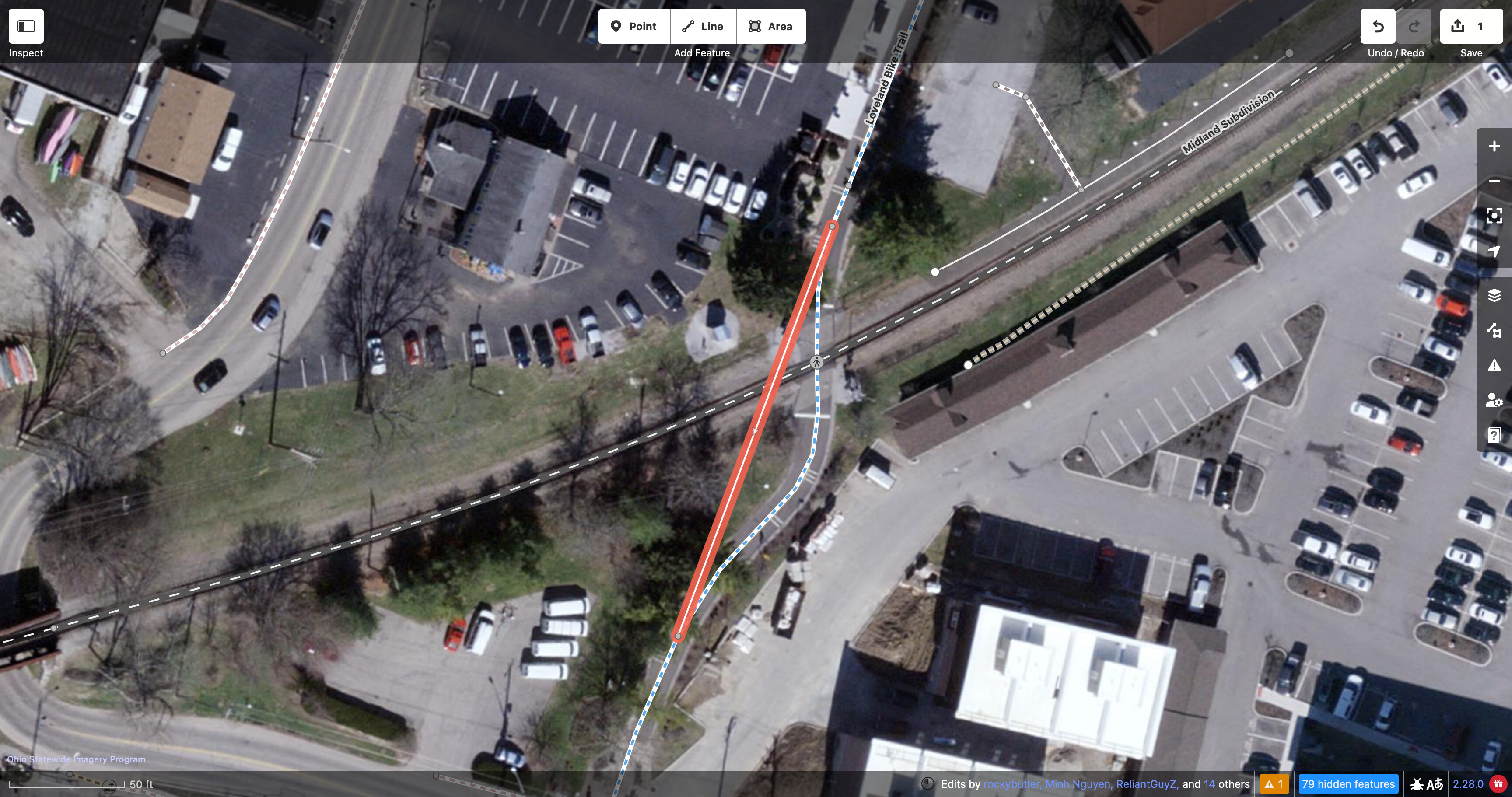
Sometimes the trail veers from the original path. For example, when crossing active railroad tracks, it needs to come in at a right angle so that cyclists’ wheels don’t get caught in the tracks. Perhaps I should’ve added a straighter railway=razed way so that no one would get the impression that the old railway junction was shaped similarly.
These tweaks would have somewhat undermined the argument in favor of abandoned railway tagging, that someone could inspect the trail itself to determine if it would be a leisurely ride. In the absence of this micromapping, maybe they can instead notice the frequent benches (sitting on what had been the tracks), or that it runs along the banks of a National Scenic River dotted with canoe rental shops. They’re doing this manually, right? If, on the other hand, they expect a cycling routing profile to pick out railway=razed automatically, then I may have to rewrite my tired joke about the self-driving car company that adopted OHM.
Sometime in the last few months, the state demolished the iron bridge in order to replace it with a gleaming concrete one. The history was getting a little too old, too familiar. Since I was the one who added this rail trail originally, I took care of updating it, including retagging the formerly preserved rails that have presumably been sold for scrap:
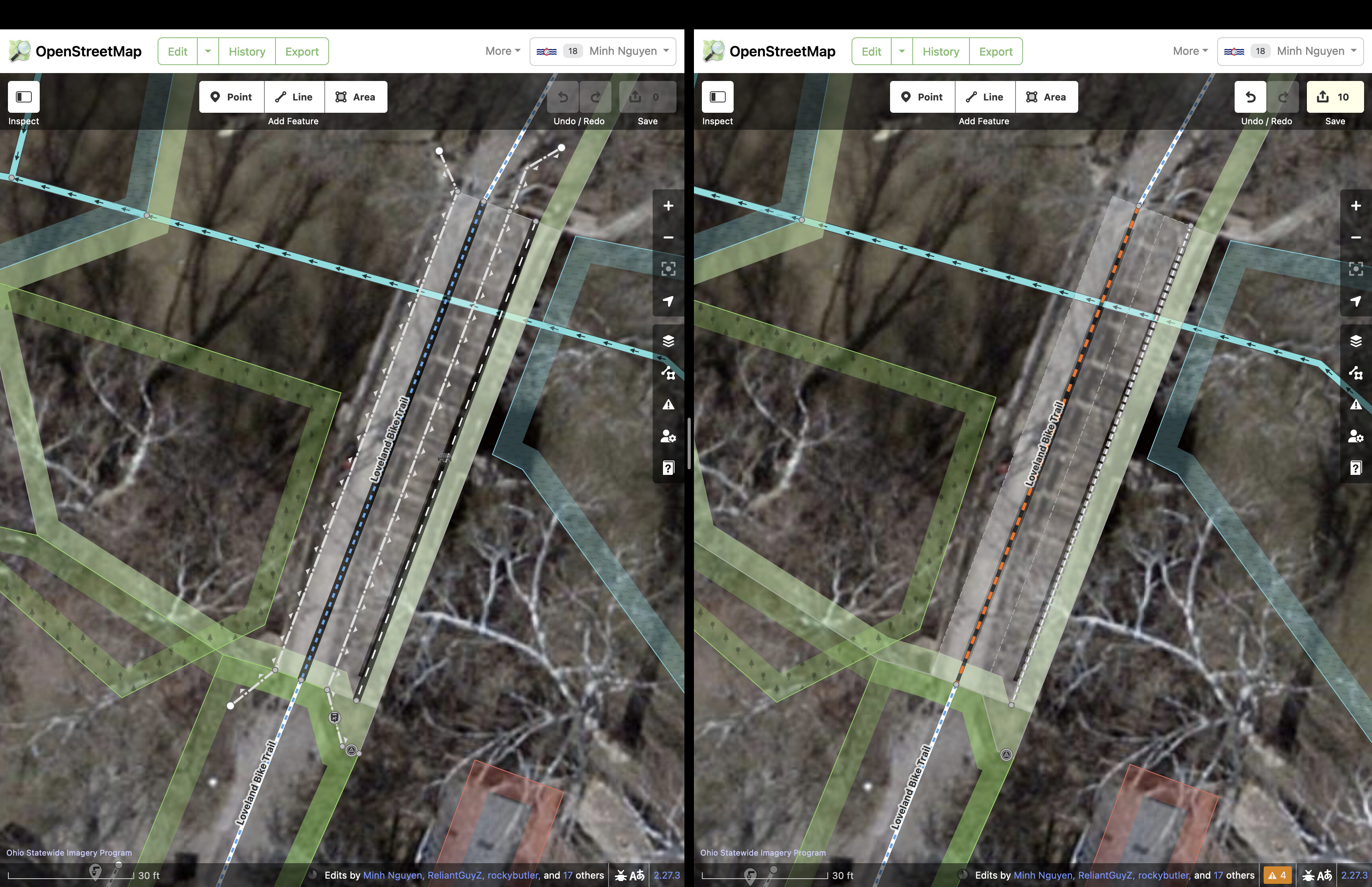
I did a naughty thing and left both the bridge and the rail as demolished features, but only because there’s still plenty of aerial and street-level imagery suggesting otherwise, and I didn’t want anyone to restore the features incorrectly in the meantime. But I deleted other minor features outright, like the wooden guardrails and the doggy ![]() bag receptacle. Should I have kept them, for consistency? Should I have micromapped them in OHM instead?
bag receptacle. Should I have kept them, for consistency? Should I have micromapped them in OHM instead?
If we decide to keep the rails but not the ![]() , that’s an editorial decision. Rules, in other words.
, that’s an editorial decision. Rules, in other words.
There’s some precedent for this in how some mappers have detailed the vestiges of old highway routes. Long ago, before OHM got off the ground, @NE2 would create elaborate route relations in OSM for the old auto trails that predated modern highway systems in the U.S. Each relation would represent a snapshot in time, such as “Dixie Overland Highway from Metter to Savannah (1923)”. They conducted quite careful research, citing out-of-copyright maps and logbooks on Google Books. (At some point, another mapper deleted the citations, because copying Google is bad, but kept the route relation itself. ![]() )
)
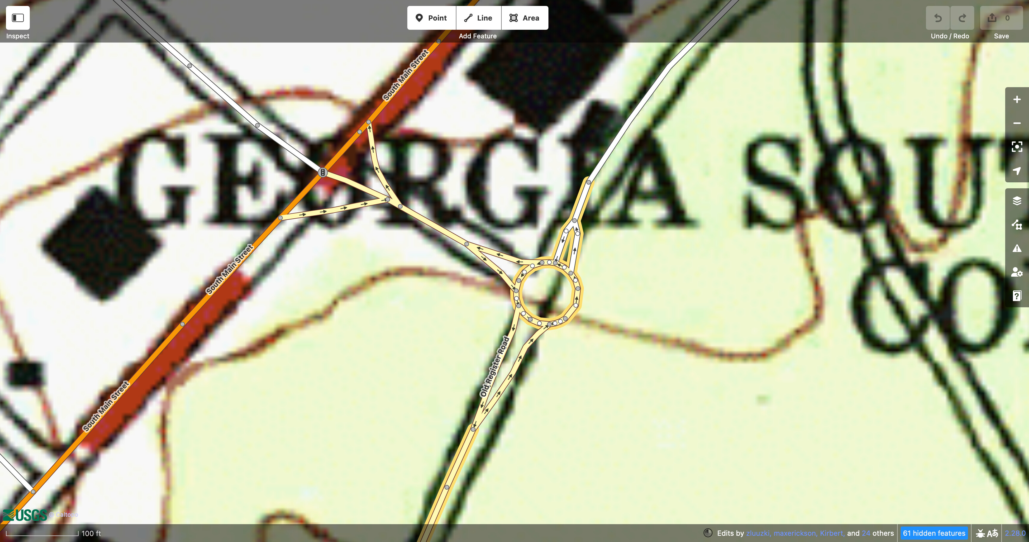
The nice thing about the auto trails is that they travel on a lot of infrastructure that still exists in some form, though usually upgraded quite a bit. Still, looking a bit closer at these route relations, I’m sometimes struck by the particular roadways that they follow. Did the Dixie Overland Highway in 1923 really follow a roundabout in a parking lot at Georgia Southern University, even though the roundabout is surely a more recent installation? The logbook makes no mention of it, even though it details the location of every turn and fork to a tenth of a mile. Apparently, the roundabout enthusiasts (or more likely the TIGER cleanup enthusiasts) paid no attention to historic railways when updating the configuration of a university parking lot.
To some extent, this is merely an example of the inherent fragility of a route relation, nothing specific to historic railways. These relations have real utility: the roadgeek community loves to organize tours of old highway routes from end to end. I’m sure railfans have a similar use case. It’s like the historical walking tours that some cities signpost, but without the signposts. Folks here can certainly think of discussions where someone wanted to add their own tour routes to the map and ran into similar questions of verifiability.
One roadgeek site, the AARoads Wiki, plots the old routes against an OSM basemap to illustrate the turn-by-turn narrative. They used to use OSM route relations to track the former alignments but frequently ran into conflicts with mappers focused on the present, so now they’ve learned to compile a list of way IDs, export their geometries from Overpass, and save GeoJSON to Wikimedia Commons. They’re slowly remapping these highways in OHM so that they won’t have to put together long lists of way IDs in the future.
This debate didn’t come out of nowhere. Abandoned railway mapping has a troubled reputation in the OSM community largely because some proponents have conducted themselves less than diplomatically. To a layperson, it can seem like a siege mentality. Both sides of the debate accuse each other of bullying and extremism and the rest is history.
To some historic railway mappers, OSM has plenty of room to accommodate residual rail features, even if it’s as unrecognizable as a deconstructed burrito bowl. How someone chooses to spend their time and effort is their own business, not mine, but I want historically-minded mappers to be aware of the opportunity that OHM provides for more expressive mapping without the friction. With or without them, OHM is going to cover historic railways; all the better if the experts are there to guide the project. Hopefully this discussion has helped the OSM community recognize the value in supporting likeminded projects like OHM.
And a big walking frog, but that’s another story. ↩︎
Google Map Maker contributors then tried to one-up us, turning the trail into a U.S. Bicycle Route, more than a decade before it would actually be designated and signposted as one. ↩︎
Neither
railway=razednorrailway=dismantledhad been coined yet. ↩︎
3 Likes
For lengthy periods of time (centuries), rail rights-of-way shape our landscape, engineering, landuse patterns, transportation corridors, following usually only minor grades for efficiency. Rail are a “thing” unto their own. I like lifecycle tagging and “migrating” data to OHM where correct and appropriate, especially in targeted areas (Johnny Appleseed-style, good examples and seeds planted for good growth ahead). These things (rail, rail services, the effects of rail engineering upon the shapes of the landscape…) have particular and peculiar lifecycles and ways to be associated with something (active freight or passenger rail, a cycleway/pedestrian path, an abandoned right of way with partial structures remaining…) that literally span centuries. Our messy tagging reflects this, these things are peculiar and difficult to talk about (widely and with consensus). We get better at it, I am sure. It might seem like it doesn’t work, but it is actually working as OSM works. Being ontological right now helps.
Minh, thank you for your poetry of a post there; that was magnificent. “Residual” is a helpful word. “Not working” is in the eye of the beholder. I see progress here, the steps to get much better at this are laid ahead like stones to walk upon. It may seem like we squabble here; sometimes a decent sketch sneaks in. We are inspiration to ourselves (if not others) at the very least.
Maybe lifecycle identifications, taginfo inventories, an interested group start talking among themselves, sharing passion and breakthroughs as they evolve. Paths ahead and skeletal structures of understanding (better, clear tagging for OSM, OHM). More forward momentum required, it’s true, though I think we can likely find that around here. This seems like a pilot project for how we’ll more fully marry the fourth dimension of time into OSM with OHM. Run with it somebody, it’s all right here to do.
1 Like
Funny you should say that…
cycle.travel does actually look out for the combination of highway=cycleway and railway=abandoned, and adjust its behaviour accordingly. It’s a really good indicator that the trail has a gentle grade, even in a narrow valley where the coarse SRTM grid might suggest the path is jumping up and down a little. So it doesn’t affect the weighting, but it does affect the smoothing factor applied on the elevation.
6 Likes
Note that if there something, anything actually left from rail itself (not just “road in the city is named Railway Street”) and mapper surveyed location then I am fine with mapping it.
Few years ago I was quite confused why grading alone would be sufficient but got convinced that it makes sense to map former railway in such cases.
What I have problem is mapping based on 150 year old map without considering or caring is it still having any actual traces.
BTW, maybe a good idea would be to have some systematic way of indicating how railway remains visible in terrain?
That would work with lifecycle prefixes just the same, wouldn’t it?
On the other hand, railway=razed straight through buildings, I hope cycle.travel does not route there!
This sounds pretty reasonable as a heuristic, but the thing about heuristics is that there’s often a more direct way to encode them in the database, if desired. A rail_trail=yes tag would still allow you to smooth the elevation profile on a trail like the one I mapped, even if I had mapped it as a separate way and left the railway=abandoned running alongside it. You wouldn’t have to weigh cases where some fragments of the trail are tagged railway=abandoned but others are not, due to micromapping.
Alternatively, you too could join OSM and OHM data to consider whether the trail overlaps a railway=* in OHM. (I have a sledgehammer, and all I see are rail spikes! ![]() )
)
But I’m not sure that your use case is really what’s motivating the impassioned defense of abandoned railway mapping in OSM. It probably has more to do with inertia and historical precedent. After all, we’ve let it slide for a decade and a half now, longer than the lifetime of a great many rail lines. Deprecating or obsoleting any tag is difficult in OSM, but it’s all the more difficult for a tag that some mappers have practically made a part of their identity. This is as much a cultural issue as a technical one.
4 Likes
There might well be a more direct way to encode them in the database but that direct way isn’t in use yet. I’m not advocating for one way of tagging or another, I’m just saying what I do based on the current contents of the OSM database.
1 Like
very interesting. But then would you agree that there is a difference between stating that this cycleway (or this embankment) should be noted as originating in a railway, and stating that this railway has been transformed into a cycleway? Objects change, mutate, and we are intersted in the resulting objects in OSM while maybe OHM is more interested in the process of change. Maybe tags should reflect the former more accurately?
Funny that you use a word with many letters here. I myself did a bit of research yesterday about something that bothered me (inconsistent statements in the wiki tag definitions) and I ended up reading about paraconsistent logics, that are explicitly aimed at accommodating inconsistencies in real world situations. Large data bases and large software systems are explicitly mentioned as applications of these logics.
I’m mentioning this because it sheds light on something we are implicitly negotiating here: consistency makes things easier for everybody including beginners, but it is sometimes costly to reach (ie ontological works) and some of us would rather live with inconsistencies as long as it does not harm them too much in their own activities.
2 Likes
I haven’t read all the posts here, but if the proposition is to start deleting all razed railways on the OSM, I strongly oppose it. I made a tour guide with a map on the net for a cycle route which for the most parts follow an old railroad bed. From JOSM I was able to retreive the parts which are no longer visible, and added this as a layer which could be made visible on the route map. In a guide like this, it is of course interesting to be able to see where the entire railway once went. Where should I have found these data if people just deleted it? To me that would be vandalism…
And I just don’t see the problem - in most OSM based maps, these razed railways are not visible anyway!
Edit: Just to show how data that may seem unnecessary can be useful for some applications, the guide can be found with the following link. It is in Norwegian, but if you select “Opprinnelig spor” in the map selector, you can bring the old railway up on the map.
1 Like
First of all, this is a cool site – I like how you presented the photos on the map. At the risk of sounding like a broken record, have you considered getting this information from OpenHistoricalMap? It looks like the Drammen Line was mapped there a couple years ago:
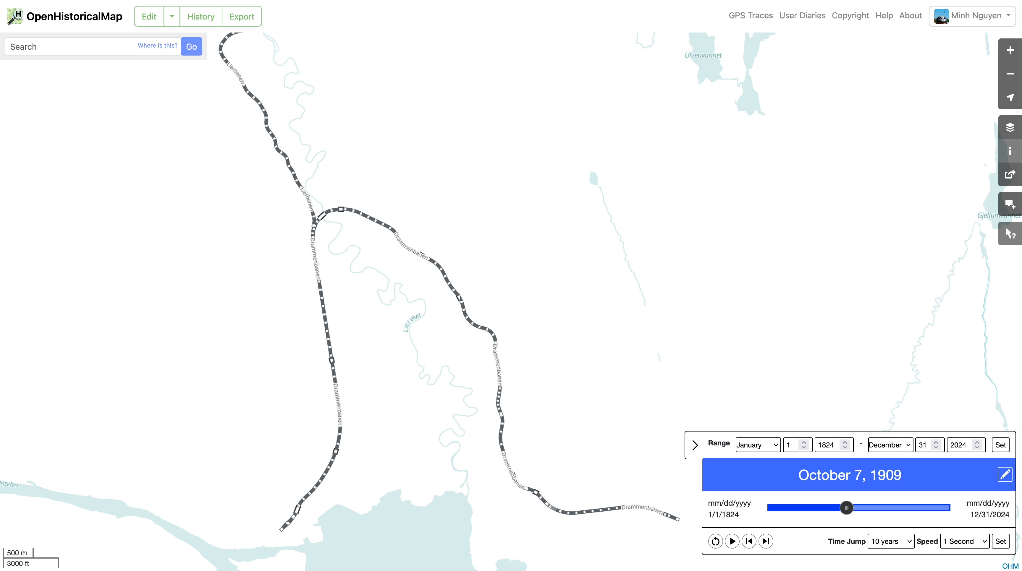
Here’s an Overpass query for the line that you can export in GeoJSON or GPX format.
3 Likes
Minh, we may need a hammer emoji for you.
7 Likes
As I often map longer-distance bicycle routes, I encounter such objects somewhat frequently in OSM (and/or, I am familiar with the overlap of the concepts of rail-trail). I do enjoy the experience (“brevity of wit in data,” perhaps) of conflating (in two tags, highway=cycleway and railway=abandoned) onto a single, directional, way object in our database. Nicely succinct.
If we might dress that up with start_year=* and such (tagging, onto a single way which shares much, including temporal inheritances), I’m OK with that. But if we proliferate the temporal sense of time into multiple ways, as that seems unnecessary to me in many or most, nearly all cases, that is needless and redundant. Databases appreciate succinct tagging. We can continue with our present sloppiness (which could be said to proliferate poor tagging due to misunderstanding) or we could “get more ontological.”
Our wiki do extend this “understanding” out to a certain distance, yet things remain persistently muddy (regarding this topic). Perhaps indeed, “tags should reflect the former (OSM) more accurately.” Yet today, they are muddy, all over rail’s complex lifecycles.
Regarding paraconsistent logics, yes, similar to “wiki chase data chase wiki chase data.” Regarding OHM, yes, the concept of “process of change” is built right in there with that “time slider.” All of this seems evolutionary, not necessarily revolutionary.
Since this is the Year of Vector Tiles on the Main Website, I was excited to try out the demo of Shortbread vector tiles that @pnorman just posted, which is updated minutely based on OSM. Unfortunately, the Shortbread schema omits railway=abandoned/razed/dismantled, so a style based on this schema can’t display abandoned railways even if it wanted to.
By coincidence, OpenHistoricalMap also has minutely-updating vector tiles, so we can composite both tilesets together on the client side so that users won’t know the difference. I filtered the OHM features to just the railways tagged with an end_date=*, so as to avoid duplicating OSM’s comprehensive coverage of the present day. I gave the defunct tracks a heavy blur so that you can distinguish them from extant tracks.
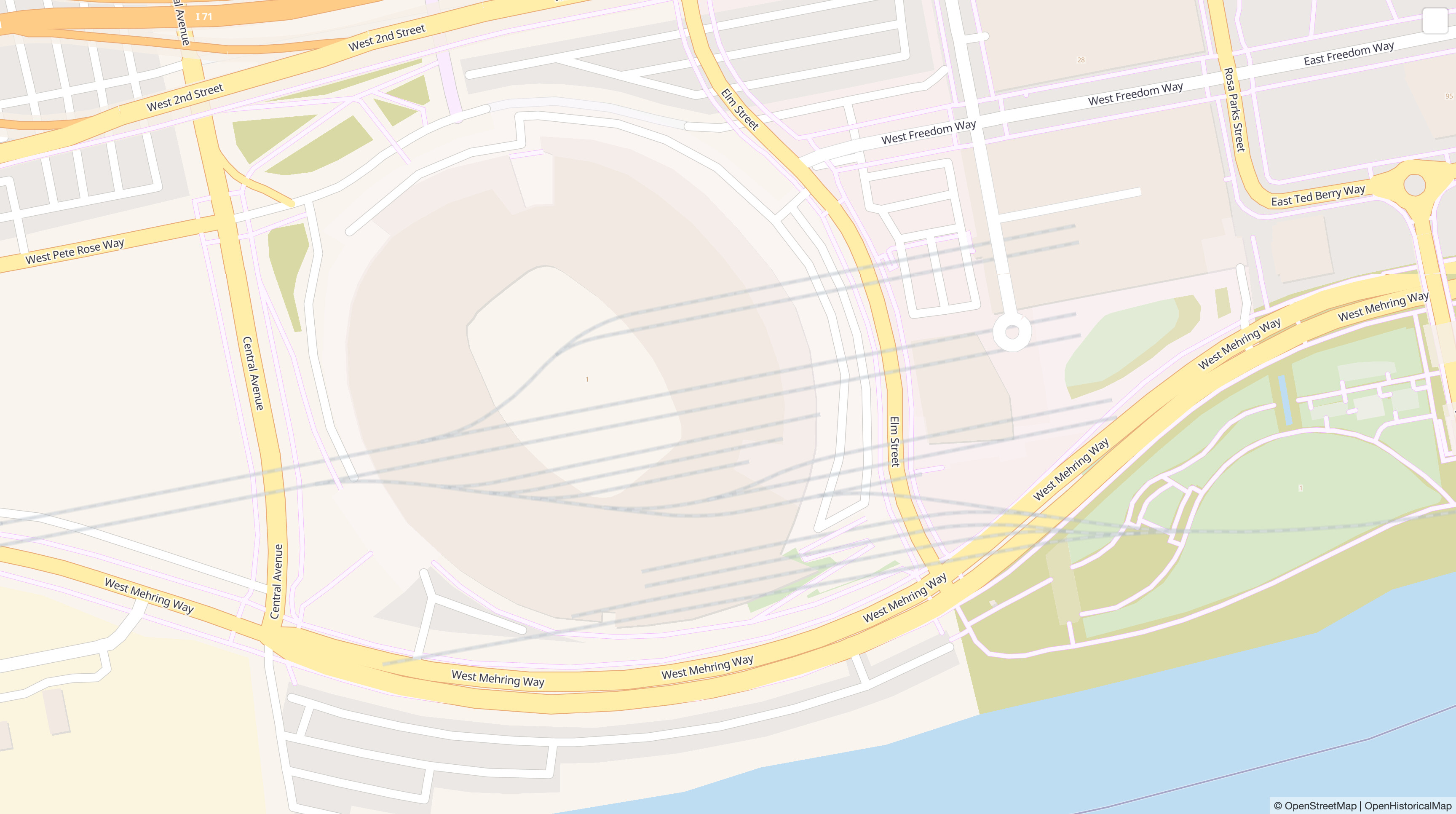
This rail yard in Cincinnati has since been redeveloped into an NFL stadium and extensive parking lots. The former sorting yard is well known to locals who remember the 1990s, but it was thoroughly obliterated and has never been mapped in OSM (compare):
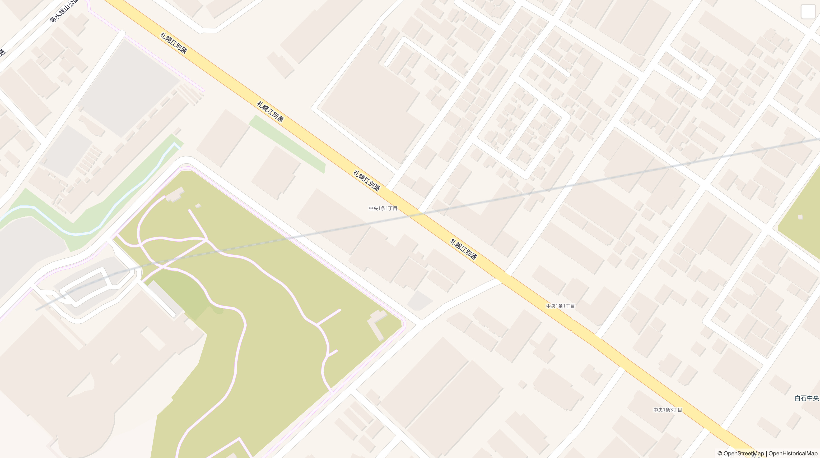
On this day in 1945, a spur of the Chitose and Jozankei Railway closed in Sapporo. It has since been built over (compare):
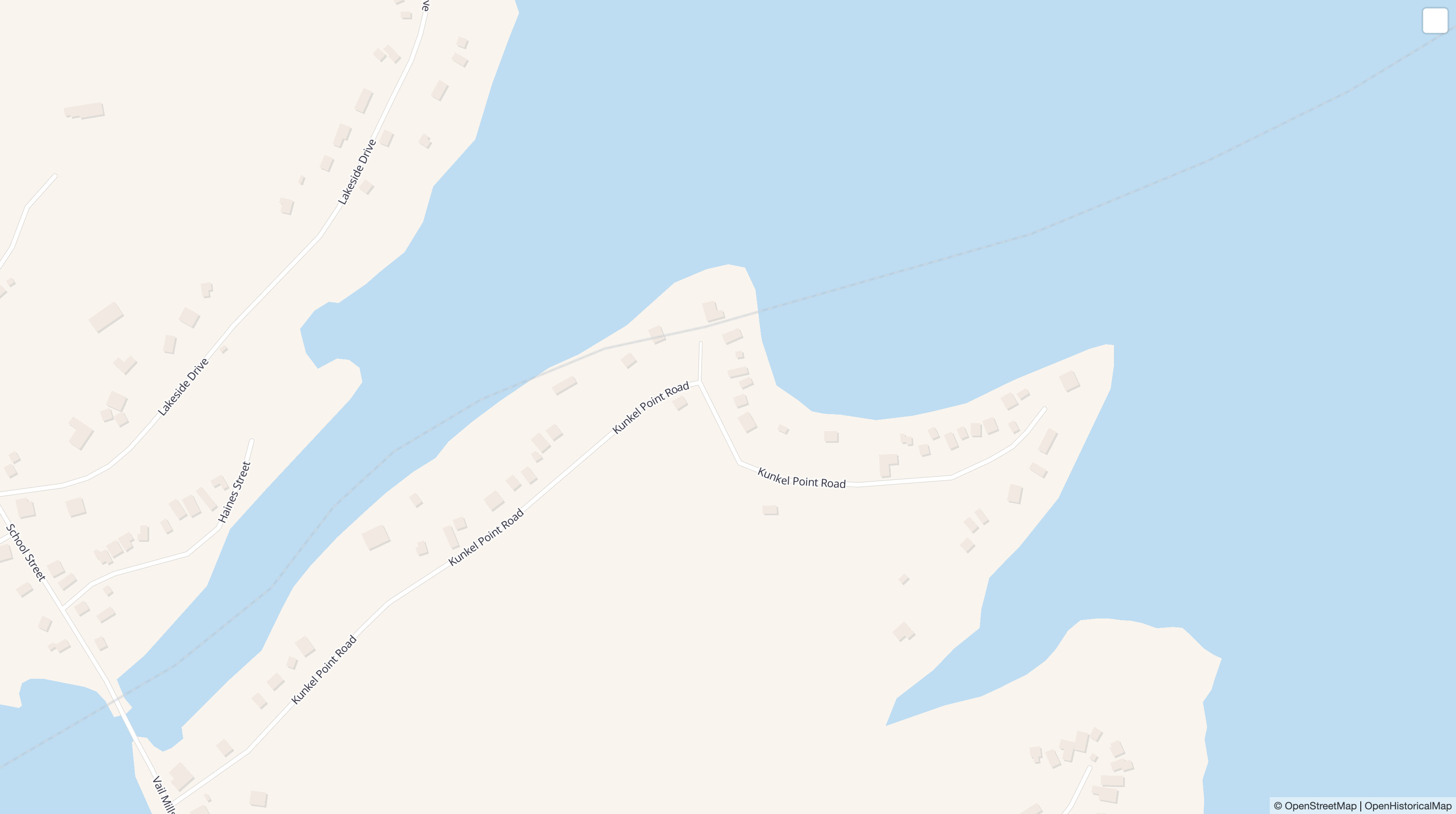
Actually, I fibbed. The track was built on dry land, but it was inundated when a newly built reservoir flooded ahead of schedule. One mile (1.6 km) of trackage was left under the reservoir until the following year. There’s still a railway=abandoned in OSM, under the assumption that some portion of the embankment must surely still be present after all these years – right? But I didn’t wait around for a wealthy eccentric to fund an expedition to the lake bottom. I added the tracks to OHM with an end_date=* and refreshed the page 15 minutes later (compare):
With a bit more copy-pasting, I could have also restored defunct highways, buildings, or riverbanks onto the map, or varied the opacity based on the elapsed time since dismantling. We’re living in the future!
The source code for tweaking the demo style is available on GitHub, in case anyone is interested in learning how to composite two vector tile sources like this.
12 Likes
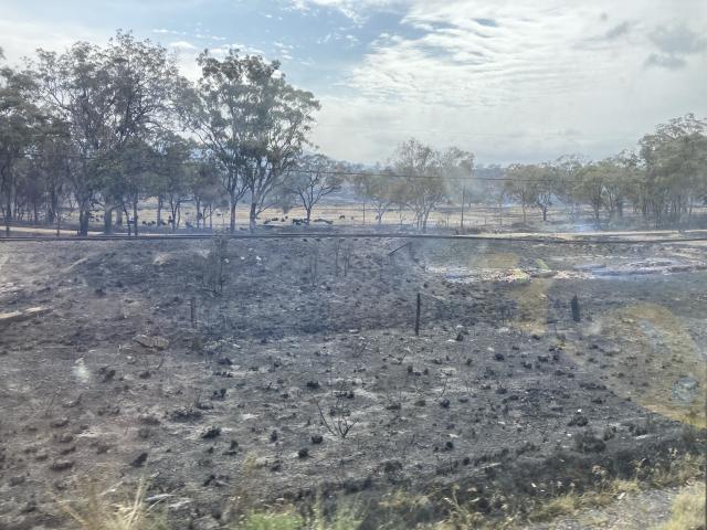
We’re travelling on holidays at the moment, & yesterday passed through an area that suffered very bad bush fires last year ![]()
Amongst other damage, these fires destroyed a number of old trestle bridges for the Heritage Railway that now uses what used to be a main-line track: https://downsexplorer.org.au/wp-content/uploads/2023/11/Wallangarra-fire-info-flier.pdf
Unfortunately, our dash-cam footage has now overwritten itself, but you can get a partial view of the remains at the right of https://stanthorpetoday.com.au/wp-content/uploads/2023/11/railway_371792_02.jpg
This photo is from earthquake & flood damage in NZ, https://res.cloudinary.com/cognitives-s3/image/upload/c_fill,dpr_auto,f_auto,fl_lossy,g_faces,h_497,q_auto/v1/cog-aap/n/605/2023/May/31/iIebXtsJ6XlyX2dNMxyJ.jpg but it was a similar effect, except that the ties have all been destroyed as well, leaving two rails hanging in mid-air by themselves! ![]()
What do we call that? Damaged / abandoned / razed … ?
1 Like
Nice historical rail map you’ve got there. ![]()
Any chance you’re looking for somewhere to store all that data somewhere like OSM, but for, you know… historical… purposes?
I have some ideas. Just sayin’. ![]()
5 Likes