Proposing to deprecate railway=razed and railway=dismantled

Believe me, I swear: I really, truly, honestly am trying to see things from your perspective. :pray:

However, to date, I do not “get it”. I don’t see what you see. Where you keep losing me is that we don’t have a common understanding of “abandoned”. You keep reinforcing the point that abandoned:railway=yes / railway=abandoned means “partially dismantled”, but you’re giving me examples of ENTIRELY dismantled things. Your understanding, to me, flies in the face of the definition at Key:abandoned - OpenStreetMap Wiki :

I don’t bristle at the idea of mapping railway infrastructure that has been abandoned, in the sense that it has been deserted and no longer maintained but is still easily recognizable for its original purpose. To me if something is only partially dismantled then by corollary it should be at least partially usable for its original purpose: in this case, having a train / tram / whatever roll along a set of tracks.

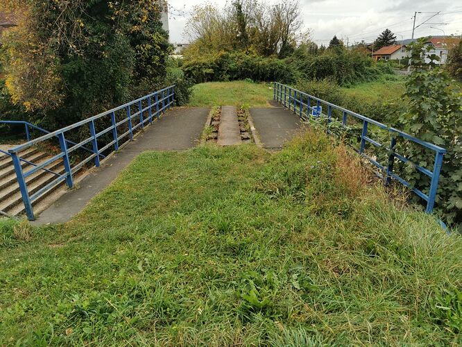
To me, that little bridge you shared a photo of isn’t a piece of railway in a “phase of its lifecycle”: there is no railway. It’s not railway=abandoned, it’s “railway=nonexistent”. It has ceased to be railway. It’s gone! And at that point, in my opinion frankly it shouldn’t be on OSM as a railway. It looks to me like it’s now just a highway=footway. You can’t “put it back into operation with expensive repairs”: you would have to build an entirely new railway.

You gave an example of a building in ruins as an analogy, but I think your analogy is fundamentally flawed, and runs entirely counter to your principal argument. A pile of rubble is categorically not a building. “Bricks in a roughly rectangular shape” outlining where a building once stood is not a building. Some fragments of a stone wall that was once a building is still not a building; all of this I think we can agree on. But where we seem to disagree is that you perceive ruins:building=yes to mean “a building that is in ruins”, that “ruins” is just a state of its lifecycle. Whereas to me it is “ruins, which happened to have been a building, at some point”. It is no longer a building, and has since become ‘ruins’. ruins:* is not a “lifecycle prefix”, it is a thing unto itself. A building will go from being occupied to being unoccupied, disused, abandoned, and eventually it will fall apart or be torn down such that it is not a building anymore, and if there’s something left it may be ruins:building. If there’s nothing left then I tend to mark the area as landuse=brownfield (particularly urban sites that will be redeveloped soon), or
 just delete it. Likewise, a railway goes from being in use, to being disused, to being abandoned, and eventually it falls apart or is dismantled to the point it is no longer a railway at all. If the path the railway followed has pedestrians walking along it it has become a highway=footway. If it has been paved over and is used by motor vehicle traffic it has become a road (with whatever level of highway=* tagging). If the path the railway followed is left fallow it’s
 nothing. It has ceased to be a mappable feature and ought to be deleted.

To me, what you’re arguing is that an “abandoned railway” consists of “the course of a former railway where the tracks are gone, but some teeny, tiny shred of evidence that it ever existed it still discernable by a railway aficionado”. That does not jive with common sense to me. Common sense tells me that a railway ceases to be abandoned:railway when it is no longer usable as a railway whatsoever, in exactly the same way a building ceases to be abandoned:building when it cannot be used as a building whatsoever anymore. If the walls and the roof are gone, it ain’t a building anymore. Likewise, when the rails are gone it ain’t a railway anymore. Sure, there may be the remnants of a right-of-way left over, and those remnants may be there for a long time, but evidence of something having been there long, long ago does not constitute still being that “something”, merely in some state of disrepair due to abandonment.

Fortunately it seems there’s very little in the way of railway=dismantled and railway=razed on the map in my little corner of the world. However, enterprising individuals have put some railway=abandoned on the map, and in these instances the very idea that it’s merely “abandoned” is risible. E.g.: Way: 335308535 | OpenStreetMap

You mean to tell me that this:


 is railway=abandoned? Even if you called this railway=dismantled or railway=razed, you might as well be telling me down is up, up is down, and the sky is green.

This way was originally tagged highway=path, about five months later someone added railway=abandoned, and three years after that someone else deleted highway=path from it and declared in their changeset comment that they did so because it was a “misused tag on an abandoned railway”. It’s been on the map as railway=abandoned ever since (almost six years).

I went and googled this former stretch of railway; do you know how long ago it was abandoned?

1976.

:neutral_face:

It’s GONE. It’s been gone for half a century. Like
 what the @#$% are we talking about here, guys? It’s a farmer’s field!
2 Likes

I agree with what hoserab has written. Aa razed railway is not a railway; it WAS a railway.

We don’t usually tag things that WERE. There are some exceptions - for example, we use “old_name” to allow people to search for old names of things, and sometimes when a building is still visible on aerial imagery
but demolished in reality, we (temporarily) put something like “demolished:building” or so, just to discourage people from re-adding the thing they see on imagery.

The image on
https://wiki.openstreetmap.org/wiki/Tag:railway%3Dabandoned
(File:Vysocany concrete rail ties former Northwestern railway.jpg - OpenStreetMap Wiki)
is something that I would accept in OSM as an “abandoned railway”; it’s
probably going to take a ton of money to make it workable again but it
is obvious to most people that this is an abandoned railway.

When even the ties are removed and all that remains is the bed, in my opinion we’re slowly leaving the railway=abandoned territory and with it
the mappability in OSM. Anything that is not railway=abandoned but railway=razed is clearly something that WAS, and not something that IS. And as such, it’s natural home is OpenHistoricalMap, not OpenStreetMap.

2 Likes

it is not entirely dismantled, there seem to be recognizable remains that I see on the photo.

Unless I misinterpret things you can see where tracks was attached and on that section railway=abandoned is 100% fine.

unlike here, though I would still ask original mapper before deleting it (grass is high enough to hide fully functional railway tracks) and obviously, would not use GSV for that verification.

(and yes, I deleted such cases when encountered)

1 Like

The main justification for mapping railway=abandoned is that the tracks aren’t the only components of a railway if only the most visible part but also includes the trackbed down below which is arguably a more important part of a railway (you can’t build tracks on any ground, after all), something which also is a very landscape changing feature. Highways, if rarer, can also be abandoned for the same reason in that the paving has been removed but the ground was kept as it is (in that case, you still have a usable way, just one which can’t be used by conventional vehicles).

In any case, I would only map where the railway went but not how many tracks used to exist nor what its gauge was unless the information still can be deduced for some reason (e.g. railway ties).

That’s true for any infrastructure which has been abandoned, not just railways. For example, I’ve mapped this former bench where you can only see one of the two supports and the seat also is missing entirely but you can clearly see that it was the same type of bench as in this region (no screenshots, though). The only way to restore it is to build a new bench, though.
Nonetheless, I would never remove this node because it still physically exists, it is a waymarker and how else should I tag this?! ruins:*=* is AFAIK only defined for buildings, not for random objects around the world (and in any case, if that stays then so do abandoned but still visible trackbeds).

It definitively looks like railway=razed but that’s past the discussion (though a lot of razed railways are mistakingly tagged as railway=abandoned).

1 Like

I have really not wanted to wade into this, but to say it “definitely” looks like railway=razed seems a bit strong!

you can use it also for benches

3 Likes

Here’s my interpretation:


highway=footway
surface=grass for most of it
surface=concrete over about half the bridge

I see
 at a stretch, railway=dismantled
 It’s certainly not just “partially” so: it is so far gone you could never hope to put this back into service without a complete re-construction. It’s only a railway insofar as there are still quite obviously ties left in the ground. You absolutely could not just slap some rails down and run a train across it; it’s much too far gone to be salvageable. I think highway=footway, surface=gravel, smoothness=
 somewhere between =bad and =horrible, is far more accurate to what it really consists of now.

highway=unclassified or highway=residential or highway=service; hard to tell precisely without more context
surface=gravel

That’s it. That second photo, again, at a stretch, is a “railway”. The others? Categorically not.

I don’t map anything I haven’t seen for myself, or couldn’t easily verify for myself in situ if I had to. Believe me: there are no rails hidden in the grass. :rofl:

2 Likes

I’d even go a step further and encourage rail mappers to redundantly sketch in some extant railways there too, so that one can see the old rails in the context of the present system. In general, OSM will always have more detail than OHM regarding extant features, such as more precise geometries, signaling, voltages, and work rules, but OHM can be the place to go for the basic information in a historical context.

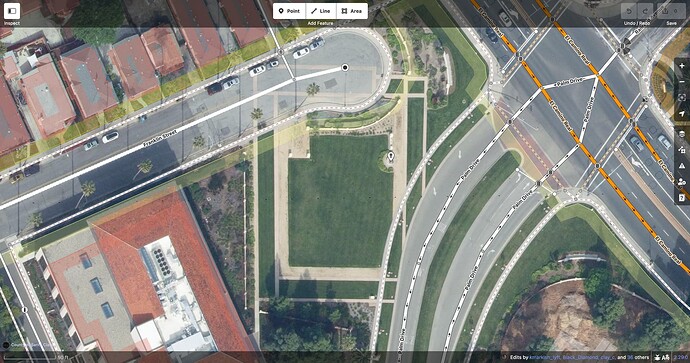
How about this pattern on a university campus that marks out the footprint of an 18th-century Franciscan mission?

This isn’t the actual foundation, just a memorial to it. Should there still be an abandoned:building=yes? Should it extend across Palm Drive? (Presumably the Franciscans didn’t anticipate this road by building a weird notch into the building two centuries beforehand, but both my source=local_knowledge and my source=survey are failing me here.)

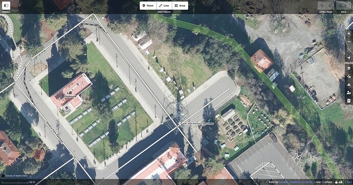
This light tower shining on an outdoor history museum is just a replica of one that blew over in 1915. Obviously, I can map it as a light tower


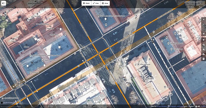
But the plaque at the foot of it also gives me enough information to map the original tower miles away, in the middle of the most important intersection in town, where there is no trace left of the tower, just standard traffic signals. Should I map a demolished:man_made=tower in OSM as well as OHM?

When I last wrote about this disused railway bridge along a rail trail, a park crew had just come and dismantled it. The best-case scenario is that they’re going to move it to a park to serve as a curiosity, like this old covered bridge. In the meantime, it’s likely living out retirement in a warehouse. When the time comes and we map the bridge area at the new location, should we leave a copy at the old location, based on the trail’s slight jog to the west and some possible fragments of an abutment? After all, this is a former bridge, right? Or was it a bridge? Or is it still a bridge, but in a different location?

I don’t think the answer to any of these questions necessarily rests on whether the feature or its backstory is interesting or enlightening. A map aspiring to be like OHM would need uninteresting things too, or else history would look too patchy to make sense of.

The issue I see is that OSM policies, tools, and practices aren’t optimized for mapping historical geography with any degree of seriousness. For starters:

  • Verifiability is primarily based on ground observation. This is a problem when a defunct railway station is only attested in an old topographic map or timetable, or the former name of a street is only attested in newspaper articles (which themselves are still under copyright). How should these sources be cited, to avoid charges of plagiarism?

  • “One feature, one element” prevents us from mapping the sometimes significant evolution of a feature’s geometry over time. This leads to definitional challenges for the two most important attributes in historical geography, start_date=* and end_date=*. Even if one can get past all the wiki’s admonitions to abstain from these two keys, start_date=* refers to different events in the lifecycle of a work of art than it does a building, and there are probably more exceptions that aren’t documented.

  • An automated bulk import of historical geodata would a nonstarter. Not that there would be many opportunities to perform such an import: despite a wealth of historical datasets out there, their authors, some of whom depend on attribution even more than we do, would chafe at the ODbL and its insistence that OSM contributors get credit while they get relegated to a mere changeset tag that downstream end users won’t ever have access to.

These stances prevent software developers from writing tools to facilitate historical mapping and significantly limit the ability for OSM data to faithfully represent the past. However much one sympathizes with abandoned railway mappers, historical features are at best a second-class citizen in OSM. One can certainly learn to appreciate historical geography by going on a scavenger hunt for relics and artifacts, but that isn’t the same as learning or teaching historical geography – just ask Dr. Indiana Jones.

On the bright side, historical geographers can still cross-reference OSM with other sources for a fuller picture. Lifecycle tagging in OSM can serve as hints for further research elsewhere. If a user or mapper comes across a little bit of real-world history reflected in OSM, it might spark an interest that grows into something larger. Just don’t fall for the trap of thinking that everything has to go in one database.

OHM still has many unresolved questions about how to model historical geography. But critically, it takes a research-oriented approach, with the classic OSM twist of welcoming amateur historians to pitch in – as long as they adopt more rigorous sourcing practices. Some abandoned railway mappers have held out hope for a grand OSM–OHM merger so they can keep doing what they do without learning new tricks, but it would require a huge change in philosophy for OSM, a bit of the tail wagging the dog. Why wait for that when there’s so much opportunity to shape a nascent project’s future, and so much fertile ground for mapping? I don’t want to ever hear anyone complain again that they’ve locally run out of things to map!

5 Likes

Your “bench” does not physically exist though. Or rather it no longer consists of that fundamental, underlying physical piece that is characteristic of what makes a bench a bench: a seat. If there ain’t no seat, it ain’t no bench! If I can’t sit on it, it has ceased to be a bench. Two supports with no interconnecting cross-piece upon which to park my derriùre is, by definition, not a bench.

I wouldn’t even map it in the first place, but I don’t see why you couldn’t use ruins:bench=yes. ruins is its own key; it’s not confined to usage on building ruins.

A support sticking out of the ground, absent a seat, is not a bench and likewise a railway with no rails—no means for a wheeled conveyance to roll along it—has ceased to be a railway.

Ballast and ties absent a pair of rails are just creosote-soaked pieces of wood in gravel. That’s it.

That, definitively, is not a railway whatsoever. I absolutely will not change my opinion on this: tagging a “railway” there is categorically wrong. There are no rails, there are no ties, there is no ballast, there are no signals, there is no crossing at the road: There. Is. No. Railway.

I don’t write this to pick on you specifically whatsoever, but I just cannot bear to mince words anymore: to suggest there is a railway in the middle of that farmer’s field is bat#@%$ &@#$ing insane.

2 Likes

You are looking at wrong wiki page here, that is not the link I’ve been sending you several times by now. You’re quoting wiki for abandoned=yes here (abandoned key), while I’m talking about abandoned:railway=yes (abandoned: prefix).

While sharing some 60% of the same letters, those two are different tags and symbolize somewhat different things. For abandoned: prefix, click here and scroll until you find abandoned:*=* in “Stages of decay” section. Pay close attention especially to the part where it talks about using it with railways.

There you’ll will find the quotes I’ve been using.

means “partially dismantled”, but you’re giving me examples of ENTIRELY dismantled things

In that picture you quoted, when one has removed some pieces or railway-specific infrastructure from that bridge (e.g. metal railings) but not all of them (e.g. concrete sleepers), than I would call that “partially dismantled”, for the reason that not ALL parts have been removed, so it’s not ENTIRELY dismantled IMHO? Can you explain your reasoning why you’d call something “entirely dismantled” when still more things remain to be dismantled from it?

To me if something is only partially dismantled then by corollary it should be at least partially usable for its original purpose: in this case, having a train / tram / whatever roll along a set of tracks.

Uh, I strongly disagree. To repeat my previous example, if some vandals partially dismantled your car by removing tires from it, it is still partially usable for its original purpose as a car? I’d say no. Would you call it usable as a car? Or would you claim that it has been “ENTIRELY dismantled” even if just (say) 2 tires have been removed from it? It does not make sense to me, I’d definitely call it “partially dismantled”.

I cannot even imagine any “partial dismantling” of railway infrastructure that would leave it in usable state for passage of trains. Removed rails? No go. Removed sleepers? No go. Even disabling signalling infrastructure would cause emergency braking to automatically engage and stop the train from moving.

To address your use case: if the railway was still partially usable for its original purpose (with little or no effort), it would be tagged by disused:railway=*, not by abandoned:railway=*. That is also documented at that lifecycle prefix wiki at the top of the message.

It’s not railway=abandoned, it’s “railway=nonexistent”

I’d disagree. While we do have razed:railway=* (again, on that same lifecycle prefix wiki) for completely gone railway infrastructure of which no trace remains (to be used for cases where it likely to be re-mapped as it is e.g. still visible on satellite imagery) this is not a case of that.

You seem to be of opinion (correct me if I’m wrong) that is it only metal rails that constitute railway infrastructure. I, on the other hand, think railway infrastructure consist of way more things, namely all the special pieces that where put there by railroad builders for express purpose of enabling passage of trains, e.g.:

  • metal rails
  • sleepers (usually wood or concrete)
  • railroad signalling infrastructure
  • railway switches
  • railway crossings
  • catenary masts and wires
  • some might argue even the ballast track, etc.

Thus, my mapping practice looks like this (not that I map railways all that often):

  • If all of them (as required: obviously electrification is not required for diesel trains for example) are present and functional and railway companies are thus currently operating trains there, then I tag that as railway=rail
  • if all of them are there, but some (e.g. power, signalization) might be disabled or there is other reason (e.g. lack of financial interest, safety issues because of overdue refurbishments etc) why railway companies are not using them for traffic, then I tag that as disused:railway=rail
  • if some of them are missing, but some still visibly remain, then I retag that as abandoned:railway=*
  • if all of them are missing and no trace of railway remains, then I retag that as razed:railway=yes until such time as risk of them reappearing in OSM (e.g. due to imagery being used) is gone.

Would you @hoserab detail at which parts you agree with that practice of mine, and at which parts you start to disagree (and why)?

Common sense tells me that a railway ceases to be abandoned:railway when it is no longer usable

I’d prefer if you used commonly accepted wiki definitions, rather than common sense. Common sense and OSM tagging often disagree (As do dictionary definition and OSM tag definitions). In particular, you seem to be mixing up what is disused:railway vs. what is abandoned:railway.

same way a building ceases to be abandoned:building when it cannot be used as a building whatsoever anymore

When roof has collapsed for example, it is hardly usable as a building, but that is exactly the case when it will be marked as abandoned:building=yes. See abandoned:building wiki.

If the walls and the roof are gone, it ain’t a building anymore

Agreed. When everything that constitutes a building is gone (walls and roof), yes, then it shall be retagged as razed:building=yes until such time it is no longer visible on aerials (so it does not get re-mapped incorrectly), and removed afterwards.

Same thing with railway infrastructure – when everything that constitutes railway infrastructure is gone (i.e. those half a dozen items I listed above), I agree that it should be retagged as razed:railway=yes until such time it is no longer visible on aerials, for the same reasons as building example.

ruins:* is not a “lifecycle prefix”,

lifecycle prefix wiki seems to disagree with your claim; it very much lists ruins:* prefix under “Stages of decay” section.

E.g.: Way: 335308535 | OpenStreetMap
You mean to tell me that this:

 is railway=abandoned?

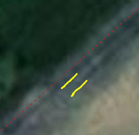
It is hard to say (Bing aerial is pretty bad there), but it does look those might be railway tracks (red dotted line is JOSM railway=abandoned, I’ve marked with yellow streaks what I think might be railroad tracks, including metal rails.

rail2

If that is indeed the case (which I am not claiming, due to bad imagery. Do you have better aerial or on-the-ground pictures?), then yes, it is definitely railway=abandoned.

I went and googled this former stretch of railway; do you know how long ago it was abandoned? 1976.

Yes, and? It just means (if Google is correct) that since 1976. it is no longer railway=rail. I don’t see why it couldn’t still be abandoned:railway=rail if nobody cared enough to go and scavenge the parts in those 50-ish years.

It’s GONE. It’s been gone for half a century. Like
 what the @#$% are we talking about here, guys? It’s a farmer’s field!

I’d need some better imagery than Bing or Esri to go with that claim. I’m not claiming you are incorrect though; as those dark lines (following my yellow doodles) might indeed be something else than railway tracks, but IMHO it is equally (if not more) likely that those are indeed abandoned railway tracks, and thus their current tagging of railway=abandoned might be correct.

7 Likes

I know there is no railway, that’s why we tag it as railway=abandoned (old syntax) or railway:abandoned=rail, to mark that there used to be one but the landscape changes are still visible (which both I and @Matija_Nalis had to remind you). Alternatively, tag them all as ruins:railway=* as that’s apparently okay for non-buildings but the punchline is that reinstalling a railway on old trackbeds should still be easier than building an entirely new railway (given the grades and the like).

Well, I think at this point for the sake of brevity I’ll just say that generally where you disagree with me, likewise I disagree with you. :smile:

As I see it, as far as I can tell, what has happened is the railway aficionados of OSM have stretched the definitions of “abandoned” and “disused” not only to the point it beggars belief, but flies off into fantasyland, and advanced those positions to “consensus” on the wiki.

I’m not going to debate the definitions per Key:abandoned - OpenStreetMap Wiki vs. Key:abandoned:* - OpenStreetMap Wiki* vs. https://wiki.openstreetmap.org/wiki/Key:abandoned:railway : you’re just playing semantics games. Where railways have blatantly gone awry is patently obvious to me looking at the table of examples from "Key:abandoned:*:

This is the example of an abandoned building:
image
Still recognizable as a building, just in a rough state. Could be repaired, but would need a lot of work.

This is the example of an abandoned road:
image
Again, still recognizable as a road. I could drive a motorized vehicle across most of this. Wouldn’t be fun, but could generally be done.

This is the example of an abandoned railway:
image

:face_with_raised_eyebrow:

Literally not a trace of it ever having been a railway other than the existence of the right-of-way itself, not yet entirely overgrown with vegetation.

I don’t think railways consist only of rails, but they are the quintessential defining characteristic of a railway, the absence of which precludes the rest from being “railway”. Signals, switches, crossings or catenaries can be part of a railway, but fundamentally they’re just ancillary; you could have a perfectly functional railway without any of it, in much the same way a road doesn’t need shoulders, signals, signage or lane markings to be a road.

Put another way:

rails + ties + ballast + signals + switches + catenary masts & wires = railway
rails + ties + ballast + signals + switches = railway
rails + ties + ballast + signals = railway
rails + ties + ballast = railway
rails + any suitable support for those rails whatsoever = railway
any combination of the above - rails = “not railway”

As I wrote above in response to Manuel, ties and ballast without rails are just creosote-soaked pieces of wood and gravel.

Sure!

  • If rails are present, functional, and railway companies currently operate trains on said rail, railway=rail.
  • If rails are present, perfectly functional, and railway companies are not currently operating trains on them, disused:railway=rail. I would also consider this tag for a reasonable edge-case where rails are not present simply because it is actively being repaired, but the operator clearly intends to put it back into service pending completion.
  • If rails are present, in a state of neglect but still somewhat functional (i.e. a wheeled conveyance could roll along the rails for most of the rails’ length), and no operator uses them and likely never will again, that’s an abandoned:railway=rail
  • If rails are absent (other than the edge-case elaborated on above) generally I would not consider such a thing to be mappable as a railway at all. “razed:railway=rail” is as far as I’m concerned a so-called “troll tag” wherein it represents the absence of a railway, where there once was a railway, purely to keep connectivity, some other historical purpose, or to prevent an overambitious contributor from needlessly adding the rails back on the map. If the rails are absent then the path they once followed should be updated with tagging to reflect their current use. It often ends up highway of some sort; maybe simply highway=path barring further redevelopment of the railway right-of-way.

Hahahaha, sigh
 The two “yellow streaks” you marked up are quite simply ruts in the dirt from a farmer’s pickup truck being driven along it. If you panned northeast from the position you marked up, at the intersection with the gravel Township Road, you’d see a dark spot a few feet from the gravel road: that’s a “cattle grid” (what we in Western Canada call a “Texas gate”). It’s a dirt road; that’s all it is. highway=track. It probably rained earlier on the day that satellite imagery was taken, and what you see as dark streaks are just shallow puddles. You want abandoned:railway=rail to be there so badly that you’re seeing things that aren’t there.

There are no rails. There are no ties. There is no ballast. I can tell you all this because, while I don’t have “better aerial or on-the-ground pictures”, I have a car and two eyeballs: I have been there and seen for myself that there is no railway there. Full stop.

Bang Head On Desk GIFs - Find & Share on GIPHY

Theeeeerrreeee iiiiiiiissssss nnnoooooooo raaaaaaaaaiiiillwaaaaaaaay


4 Likes

Don’t say it too loudly or we’ll get to witness a side debate about the distinction between disused:landuse=railway and abandoned:landuse=railway. Oh and razed:landuse=railway – how could I forget that the ground can also be razed to the ground?

An important component of a “railway” (the colloquial word in English, not our OSM definition) is the right-of-way. Lacking something like a deed from a rail company transferring ownership to a rails-to-trails program (for example, where even the railway company doesn’t own this right-of-way anymore to run trains on if they had more money than there are atoms in the universe to rebuild this right-of-way AS a railway, a real working one).

So, without ballast, without ties, without rails, can it still be a “railway”? Yes, in some sense of English. As to whether it is a “railway” (abandoned, dismantled, razed
) in the OSM definition, that’s what we seem we’ll argue about into eternity. Something like a “once was” or a “might be or is a” right-of-way (maybe for future rail, maybe for pedestrians, cyclists, equestrians
), it is a “way” of sorts.

I’d guess that a lot of right-of-ways like this which are tagged as railway=[dismantled, razed...], even as people self-crack their skulls with frustration that “there is no railway,” might not be able to say one way or another if a once-had-rail-here right-of-way exists or not. Chances are it does, and that might be what many want for OSM to continue to capture as data.

Edit: Maybe railway=dismantled can stay, but railway=razed becomes railway=right_of_way_only ? And we use a picture of “nothing,” except there is an (old) railway right-of-way? But then we’d get into owner=* and operator=* tags likely being needed to clarify
hm, that’s not terribly onerous. It seems like landuse=railway could serve a same or simlar purpose, especially if more-precise data are available of exactly the right-of-way width (and general shape, etc.).

Oh god, what hellish Pandora’s box have I opened? :man_facepalming:

9 Likes

Take it easy @hoserab, this is almost a perpetual OSM joke at how the ra-ta-ta of the saw blade going back and forth, back and forth, back and forth (about this argument).

Truthfully, more people are chuckling about this (going on like this for so long) than are actually annoyed that it does.

1 Like

I’m going to BC next week for work, and part of me wanted to make some side-trips whilst I’m in the middle of proverbial nowhere to gather some boots-on-the-ground info for OSM. Now part of me also wants to get some of the contributors to this discussion thread to try to suss it all out with satellite photography, just to see what shenanigans they’ll come up with. I’ll be way up in the mountains; maybe while I’m there they’ll find Bigfoot for me.

Have deleted many a mile of former railway past the razed state, coastal cycleway smack top off with beautiful smooth bitumen and galleries, the former rail returned to the furnaces, A street known as Strada Parco and imminently having opened a trolley bus line over it. But for a few meters, the watering house, a locomotive on display, just asphalt. Gone, no more snapping while map maintaining to these ways at layer=-1

(Of course one came to town and started mapping all these lines through town again where the wiki is pretty clear when not)

I think you have a fair point about some mappers going too far in mapping railway infrastructure that has completely disappeared - I suspect I would agree with you about the farmer’s field example if I visited it in person. However


Nobody is claiming it would be mappable “as a railway”. People are saying that it may be mappable as railway infrastructure, depending on what is left. Just as nobody who maps “highway=bus_stop” is saying that the bus stop is literally a highway, and nobody who maps a ruined building is saying there is currently a usable building, nobody who maps “abandoned:railway” is saying there is literally a working or workable railway there. You are harming your own argument by repeatedly arguing against a position that nobody is taking.

Perhaps I have some sympathy with mapping the remains of railways because I grew up near an abandoned railway. It was closed in 1958, and the tracks were lifted and sold off. But most of the alignment remained and was protected from construction. As the population of surrounding suburbs grew, it became obvious that abandoning the railway had been a terrible idea in the first place, and a tram line was built along the route, opening in 2010.

I think that if OSM had existed during most of that period of abandonment, it would have been reasonable to tag the right of way as abandoned:railway:

  • It was an identifiable feature in the landscape that could not be adequately captured by other tags (as far as I remember most of it was not even usable as a path)
  • Both the purpose and identification of that feature were verifiable, among other things by asking locals (I was born well after it closed, but knew it as “the old Harcourt Street line” for as long as I can remember)
  • The fact that the alignment was chosen to build a tram route, in preference to any other possibility, shows that it was still a meaningful piece of physical infrastructure, not just an idea that “something used to be here”. The fact that the tracks had been torn up was a relatively minor factor compared to constructing a whole new alignment.

To be clear, I am not saying that it is right to include any former railway in OSM regardless of what is on the ground. I am just saying (as I think are many others here) that abandoned railways with no rails can persist for a long time as identifiable infrastructure that does belong in OSM.

10 Likes