We got lucky. ![]() This example was hypothetical but not entirely contrived, given the squabbling in this thread about how much Theseus can modify a railroad before it ceases to be a railroad.
This example was hypothetical but not entirely contrived, given the squabbling in this thread about how much Theseus can modify a railroad before it ceases to be a railroad.
I’m glad to hear that you see many examples of well-researched abandoned railways. We need more people to spend time double-checking the abandoned railways for accuracy if we want anyone to trust our coverage of them. “Conjecture” is a good word to describe what happens sometimes. It seems to me that conjecture happens more frequently for abandoned railways than for just about any other kind of infrastructure, with the possible exception of pipelines and sewer systems.
I keep picking on this segment of the Fonda, Johnstown and Gloversville Railroad because it was originally mapped straight through a reservoir based on a description in a local history book, with the apparent goal of completely representing the book’s railway listing in OSM. When pressed, the mapper fell back to the on-the-ground rule (“How can you tell it’s gone?”), proof by authority (“Ask me before deleting it!”), proof by acuity (“I have an eye for these things”), and some other things unfit for this forum.
In fairness, I only know the rails have been salvaged because of a self-published blog, which is not as solid as the proof of the tracks’ one-time existence. Ostensibly, the only reason this railway remains in OSM is that, even if the rails have been salvaged, no one can prove beyond a reasonable doubt that the railbed has disintegrated beyond recognition. Since no one can prove its nonexistence, it must exist, right?
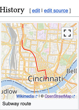
Every now and then, someone finds out about the unfinished subway in my hometown and feels the urge to map it somehow. Even though one can sometimes arrange for a tour, these mappers don’t concern themselves with such niceties as on-the-ground verifiability. They map a route out of railway=abandoned ways that seems plausible except to a local. The subway does follow street rights of way, but I can find no source that supports the existence of any of the subway tracks in the following view:
This part of the route is entirely fictional. Maybe the mapper misinterpreted the “Stubs for incomplete loop route” in this Wikipedia route diagram to mean that there’s a little loop at each end of the route, but actually that’s a reference to the original plan to have the route loop around the city.
Another mapper later came in to remove some of the above-ground portions that were completely demolished for freeway construction, but the rest of the route remains because I’ve haven’t been able to catch a tour when I’m in town. Meanwhile, in a lovely case of citeogenesis, Wikipedia now sports this route map, courtesy of us:
These examples are factually incorrect, violating multiple OSM guidelines regardless of tagging. But I think it comes back to that issue of trust. Nowadays when I see a railway=abandoned appear out of nowhere, I have to be prepared for the possibility that it’s just speculation because that’s what I’ve seen before. This is unfair to the people who map abandoned railways more rigorously.
Yes, that prior research is key, and as I’ve stated, I think most rail mappers do consult other sources, using aerial imagery only to refine the location. If only they would document their methods and sources upfront.
Anyways, I don’t think I’m arguing for the position you seem to think I am. At the end of the day, I don’t really care whether we deprecate railway=abandoned and railway=razed, which was how this thread started, because I think it attacks a symptom rather than the root cause. The antipathy towards these tags is the result of their misuse, not any inherent uselessness. Moreover, the increasingly narrow justifications for these tags only underscore the value of mapping old rail infrastructure in OpenHistoricalMap – citing sources – compared to only mapping their remnants in OSM.
Most rail trails in the U.S. are in areas with flat terrain, and many towpath trails are far from the coasts and rivers that they connect.

