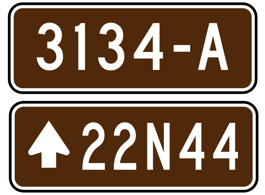
As most of us here may be aware, the US has probably the most complicated and fragmented route signage system of any country in the world. We’ve made good progress as a community on devising tagging schemes for most nationwide, statewide and local route=road networks, though there are still a few odds and ends that haven’t been worked out. Notably, the US Forest Service (USFS) is one of several federal land administrators that signpost their own routes. The National Forest Road System has a distinction between Forest Highways (or Primary Routes), signed with trapezoid shields, and Forest Routes (or Secondary Routes), whose signage is a horizontal or vertical rectangle depending on the maintenance classification of the road (which tells you whether the road is passable for a typical passenger car).

The current situation
The network=* tagging scheme for route=road relations belonging to the National Forest Road System, according to the United States road tagging wiki page, is US:NFSR:<forest name>:NF for Forest Highways and US:NFSR:<forest name>:FR for Forest Routes:
Required. An example is
US:NFSR:Chequamegon-Nicolet:NFfor a National Forest Highway, orUS:NFSR:San Bernardino:FRfor a National Forest Road.Distinguishing the network in this way will keep individual National Forest Road systems distinct, and also allow for future shield generation corresponding at least to ‘Distinctive Route Markers’ and “other NFSR routes”.
While this seems to be the predominant tagging scheme, it disregards the distinction between Forest Routes with vertical and horizontal signage. Moreover, in the case of OpenStreetMap-Americana, the inclusion of each National Forest’s name has actually hindered shield rendering support, as the name of each forest must be enumerated in the underlying code. Signage is identical from forest to forest, which makes me doubt whether this is necessary information to include in network=*. Perhaps operator=* is a better home for it, if it isn’t easily deductible from a spatial query.
Proposed tagging guidelines
In order to distinguish between routes with different shield appearances and better match shields to network=* values, the following is proposed for route=road relations:
- deprecate
network=US:NFSR:* - define three values of
network=*for the National Forest Road System:US:USFS:primary: Forest Highways (aka National Forest Primary Routes)US:USFS:secondary: Forest Routes (aka National Forest Secondary Routes) with horizontal signage, indicating a maintenance class of 3 or aboveUS:USFS:secondary:low_maintenanceUS:USFS:minor: Forest Routes with vertical signage, indicating a maintenance class of 1 or 2
- add
operator=<forest name>if necessary to disambiguate roads with the sameref=*andnetwork=* - do not use a prefix in
ref=*(same as before)
The following is proposed for highway=* ways:
- use
FHas a prefix inref=*for Forest Highways - use
FRas a prefix inref=*for Forest Routes (regardless of maintenance class)
The prefix US:USFS: was chosen to be consistent with other federal agencies that signpost routes, namely the Bureau of Indian Affairs (network=US:BIA) and the National Park Service (network=US:NPS:*). As for ref=* tags on ways, there isn’t an obvious way to distinguish high-maintenance and low-maintenance Forest Routes, but it’s probably not necessary anyway. Data consumers that process this tag on ways are agnostic about which one of a variety of possible networks the route may belong to.
I considered going through the formal proposal process on the Wiki like last time, but this issue has a much smaller scope in comparison. I hope we can come to a consensus about these routes one way or another—I know a lot of us are dying to document these routes and have them show up in OSM.