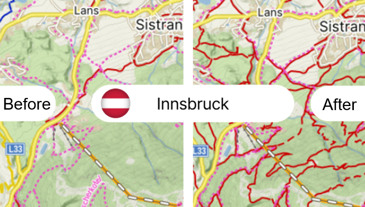
Mapy.com "new" hiking routes data

Hi everyone, greetings from Tschechien.

Last week, the Czech commercial map service Mapy.com, which used primarily OSM data outside the Czech Republic, announced the addition of new hiking trails not marked in OSM for the whole of Austria region, claiming they have added several tens of thousands of kilometers of new routes. See: Maps.com redrawn Austria. Thousands of routes added (the new data is available on web)

We have discussed this in the Czech community and then I have contacted the Austrian community on Matrix. The source of the routes is so far unknown, but I also contacted Mapy.com to ask them, so I will update on that as soon as I hear back from them.

What we discussed so far: From my investigation, the path and highway ways geometry on Mapy.com is still kept from OSM and is only labeled with marked trail. The new data actually adds a lot of new marked trails, see for example the region around Innsbruck: Mapy.com & Waymarked Trails - Hiking . The source is unknownand does not seem to align with ÖAV Wegedatenbank niether with Kompass.

Any insights to what might be the source, whether we could somehow utilize it or whether the Mapy.com data are more/less relevant than OSM is welcome.

Thanks for posting it here too! (I think the working URL of the Czech source is Maps.com redrawn Austria. Thousands of routes added )

Und als kleiner Service für alle die noch nie mit dem österr. OSM-Matrix-Chat zu tun hatten und gerne nachlesen möchten was dazu bisher besprochen wurde, dessen Link:

FWIW, I don’t know how accurate the details in that article are.

The cartographic editorial team of Mapy.com therefore did not adopt the Austrian network, but created it anew. For individual routes, they verified their existence, actual course and marking method, and then plotted them in their own database.

They almost certainly did not create and verify all routes themselves. It seems like they got access to a different database (or potentially multiple databases) of hiking routes and used that instead. It’s unclear where their data is coming from.


Copying some posts from the matrix chat here so they are available in the forum:

Discussing the data source

KaiRo

Woazboat

There’s a before-after comparison image on their website. Maybe someone with access to other maps (e.g. ÖAV) can check if they match the new routes. https://blog.seznam.cz/wp-content/uploads/2026/08/mapy-at-stezky-en-verze.png

It looks like all the ways in the comparison image exist in OSM. Maybe we don’t have routes along all of them, but it’s IMHO also unclear how many of those routes make sense. Just because someone has them somewhere doesn’t mean they are actually useful routes.

Yepoleb

I assume the reason these routes are not marked in the original osm data is because they are not observable on the ground. Here in tyrol it is rare that paths are marked with numbers as the mapy data suggests. When they do, it is usually already recorded. Proper names are more common, like Speckbacherweg in the example.

Yepoleb


I found an old map by my local tourism office, unfortunately it cuts off before sistrans, but you can see where they got the route numbers from

Yepoleb

these are not officially recorded anywhere though to my knowledge. GIP doesn’t have them, ÖK50 doesn’t have them, state GIS doesn’t have them. They are a result of the cooperation between the tourism offices and kompass, a private map publisher, who has produced these maps for tourism for multiple decades

PPete

Very interesting project by Mapy.cz, I’m curious what their sources are. It’s definately not BEV. Most matching hiking-trails are those of the 2 most used hiking maps in Austria: Kompass and Freytag & berndt. But Mapy.cz is not using a 100% copy of them, cause some routes are missing, some just in Mapy.cz. And Mapy somehow did manage it to adapt the routes (of a probably Non-OSM source) to the OSM-ways. And Routes which are present in e.g. Kompass, but can’t be present within OSM because of missing OSM-ways are not present in Mapy either. I don’t know any other country-wide source of hiking trails other than the 2 mentioned companies (which by the way joined together last year)

PPete

And in general: Since I worked a lot with hiking routes within OSM in the past I know: There are lots of marked hiking-routes missing in OSM in Austria. Meaning most of ways hikers are using are present in OSM - but not its hiking-routes. So the number of 10 thousands Km of missing hiking-routes in Austria is probably true.

PPete

.. and it’s also not the last country-wide source I forgot to mention: “ÖAV Wegedatenbank” where all alpine clubs (not only ÖAV) share their routes. Mapy has routes which aren’t present in ÖAV-Wegedatenbank.

Yepoleb

PPete

And in general: Since I worked a lot with hiking routes within OSM in the past I know: There are lots of marked hiking-routes missing in OSM in Austria. Meaning most of ways hikers are using are present in OSM - but not its hiking-routes. So the number of 10 thousands Km of missing hiking-routes in Austria is probably true.

Hard to say without a proper information source. The mapy numbers are definitely inflated, because slapping a number on a path and calling it a route is hardly meaningful. The tourism office should be the definitive source, but i question if they even have a database that is separate from kompass.

PPete

I doubt that it’s Kompass-based, at leat not all over the country. Why shouldn’t Kompass print all of their Hiking-Routes onto their own Hiking maps? Because I’ve seen some Mapy-Routes, which aren’t present in latest Kompass’ hiking map.
And about the fact that quite a lot of hiking-routes are still missing in OSM: I know that, cause I’ve worked several years to add or improve hiking ways in OSM. A rough estimate: I wouldn’t be surprised if about one-third to one-half of all marked hiking routes in Austria are still missing from OSM.

Woazboat

PPete

And Routes which are present in e.g. Kompass, but can’t be present within OSM because of missing OSM-ways are not present in Mapy either.

Interestingly enough, I’ve found an example where there is a route section marked in Mapy where there is no OSM way

Mapy.com
Waymarked Trails - Hiking


Licensing

Woazboat

From a license point of view, the new mapy hiking route data is uhhh… interesting. To draw their new route data on the map, they definitely need to do map matching to the existing OSM ways, which are ODbL licensed. That means they created a derivative database, which is required to also be licensed under the ODbL.

Ondřej Lopatka

I thought of this in a way how they do the stitching so they match presumably different geometries of paths that are labeled as marked trails. Do they only take the “markings” information or also the geometry of paths. Then to your point I am not really sure how this is legally.

Woazboat

If their new hiking route data has its own separate geometry and they just overlay that on top of the map without ever using geometry information from OSM, then they could keep their data licensed separately with whatever license they want. However that would mean that we’d very likely see a mismatch between the OSM highway geometry and their hiking route geometry (e.g. offsets, different curvature, etc…)

As soon as they use geometry information from OSM and combine it with their hiking route information to be able to draw the routes exactly on the OSM ways, the ODbL share-alike clause is triggered


Data quality spot check

Woazboat

I just did some spot checks and at least in some cases OSM is more accurate than whatever data source they are using
Mapy.com
Waymarked Trails - Hiking

The “Jakobsweg Weststeiermark” route here has been changed at some point and was updated in OSM in 2023. Mapy is still(/again) showing the old route via Plankenwarth.
Changeset: 133128850 | OpenStreetMap

You can see route marker stickers for the new route here in this street view image from August 2025
Google Maps

Funnily enough, the official website for the hiking route also still describes the old route 1. Etappe Weststeirischer Jakobsweg Thal - St. Pankrazen - jakobsweg-weststeiermarks Webseite!

Weil Innsbruck angesprochen wurde. Die Karte angeschaut. Nicht schlecht. Nicht nur bestehende OSM Routen Relationen erhalten jetzt die “Wanderweg” Dekoration, sondern auch noch eine Menge mehr Wege. Das aber nur außerhalb der Stadt, nicht im Inneren. (Man könnte ja dort genauso gut “Wandern”, jeder und jede nach ihren Vorlieben.)

Meine Ansicht: Es wurden gar keine “Routen” im OSM Sinn angelegt, es wurden nur die “hiking trails” auf der Karte deutlicher hervorgehoben. Also Wege, auf denen gewandert wird. Wie erkennt man, ob etwas ein Wanderweg ist?

  1. Die OSM Antwort - Der Weg ist Teil einer Routenrelation Typ hiking oder foot, dann rendert es waymarkedtrails.
  2. Die TVB Antwort - Man stellt gelbe Wegweiser auf, die ein paar Ziele aufzählen, und natürlich Sitzbankln :smile: dann erkennens die Leut.

Nicht ausgeschlossen, dass mapy eine KI auf das angesetzt haben. Davon hab ich schon einmal im Carto issue tracker geträumt, die das erkennt, wo es Wegweiser und Sitzbankln gibt, genau so wie es die Leute machen? Mit Frequenzdaten vermischt (Strava) sicher viel möglich.

So gesehen dann wohl auch keine Probleme mit abgeleiteter Datenbank, es wird nur die Darstellung ergänzt, das styling der Daten.

PS: Die refs und Namen kommen meist von den Steigen selber, wenn in grau angeschrieben. Routenrelationen Typ foot werden ignoriert.

Update: Bewegungsdaten haben die vielleicht sogar selber. Das Produkt ist sehr beliebt.

O weh… Ich habe bisher mapy.cz ganz gerne verwendet, die Geländedarstellung ist fast unübertroffen, und die aus OSM stammenden Wanderwege bisher sehr übersichtlich dargestellt. Mir fiel jedoch kürzlich auf, dass in Regionen, in denen ich in den letzten Monaten OSM-Korrekturen an Wegrelationen vorgenommen habe, manche in mapy.cz nun inkonsistent drin sind: von manchen Markierungen gibt es leider nun fallbacks zu (tw. viele Monate) alten Versionen, die offenbar in einer älteren Datenbank zwischengeparkt waren und nun die aktuelleren Versionen überschrieben haben. Ich kenn mich mit KI ganz wenig aus, aber ein wenig erinnert mich das daran… Jedenfalls leider keine Verbesserung…

I made a few phone calls today to find out who is responsible for the numbered hiking routes around Innsbruck, as are shown in the Mapy announcement.

First I called my townhall and asked for someone who is familiar with the path numbers. I was redirected to someone who was not really familiar with the topic and he voiced his frustration with being assigned my call, but still tried to help me. I got the contact information of the forester, who might know more, and the hint to ask the tourism office, which I was planning to do anyway. I also go the information that the local tourism office is permanently closed down, as it was managed by a single person who died, and now there is nobody who feels responsible.

Next step was the tourism office of Tourismusverband Innsbruck und seine Feriendörfer (yes, that’s the legal name). The person responsible for infrastructure told me they definitely have no data on hiking paths. The maps they publish are made by map publishers and they just contract them. Route signs are put up with their destination and the estimated walking time, but no route numbers. This is because they were never properly catalogued and it is impossible to verify them nowadays, the local people could theoretically just make them up. What is actually properly numbered are the mountainbike paths. He gave me the hint that the german alpine club may have been behind route numbers in the early days, but they have since transferred responsibility for maintaining the hiking paths to the austrian alpine club, so there is no point in bothering them about it. Also I should call the forestry department of the state Tirol and ask them if they have any data.

So I called “Abteilung Forstorganisation” next. They quickly told me they have no data on hiking paths, I should ask the tourism office or alpine club.

The austrian alpine club ended up being among the most helpful contacts. I got explained that as a general rule, numbers 1-10 are assigned to the existing long distance hiking paths (Weitwanderwege Österreich), 11-99 are assigned by local tourism offices and everything tripple digits is maintained by the alpine club. Although sometimes paths change responsibilities, so it is not always that clear. Alpenverein maintains a public dashboard of their paths, but not everything is digitized yet. For what I’m looking for, Kompass has the most extensive dataset and is most likely the definitive source. Some municipalities have started buying software and maintaining their own route database, but they are few.

I cannot contribute much to the Innsbruck area, but there are many hiking relations on OSM and many are missing. AFAIK, there is no single comprehensive source for hiking relations in Austria (also the Alpine clubs are trying, but not successfully so far). But since some peculiar recent change on mapy.cz, some hiking relations there have become worse than before, although there is recent and better data in OSM available. Obviously, mapy.cz took a lot of outdated data and overwrote the better data (see my above post in German language), which I regret.

Ich hatte da eine Unterhaltung mit jemandem, der vor Ort (Mittelgebirge, Ampass Rinn Gegend) Wanderwegschilder gewartet hat. Wenn ich recht erinnere vom lokalen TVB. Die Mär ist eine recht ähnliche. Die Routen wurden von jemandem gesponsert der mittlerweile ausgeschieden ist. Ein paar davon werden am Leben gehalten, andere gehen vor die Hunde und die Schilder verwittern oder verschwinden ersatzlos. Als kleiner Bonus wurde mir erzählt, dass es auch Leute gibt, die solche Schilder entfernen, weil sie auf ihrem Grund keine Wege haben wollen. Da hat er immer wieder Arbeit, die neu anzubringen, und das geht ganz schön ins Geld, hat er gemeint. Das wird aber eben nicht für alle “Routen” gemacht.

Kurz gesagt: Die Art und Weise wie Wanderwege auf OSM hervorgehoben werden, nämlich über Routenrelationen, ist ganz und gar nicht auf das zugeschnitten was rund um Innsbruck so abgeht. So eine “Route” von vorne bis hinten abzugehen allein mit dem was an Schildern so herumsteht nicht immer trivial. Wenn ich mir das anschaue, was mapy (com oder cz?) da hingezaubert hat, dann finde ich das nicht so daneben. Letzten Endes gehts meines Erachtens schon ein wenig darum, die gewarteten Wanderwege von den Schwammerlsucherwegen und Rehgangeln unterscheidbar zu halten. Das passt ganz gut so wie die das rund um Ibk hin gebracht haben.

Die Alternative dazu, alles was irgendwie mit den wohlbekannten gelben Wegweisern ausgeschildert ist in eine Sammelrelation zu packen, was ja schon mehrmals gemacht und auch revertiert worden ist, die könnte damit tatsächlich einen kleinen Dämpfer erfahren (zumindest bei Leuten, denen es darum geht, wie 's auf mapy aussieht). Die wieder andre Alternative, ein Knotenpunktnetzwerk aus den Fingern saugen, das scheint mir etwas für Leute mit wirklich sehr viel Freizeit und Lust drauf die vorm Bildschirm zu verbringen.

PS: Die Rumer Wanderwege sind teilweise so alt, da warst nicht nur du noch nicht auf der Welt, von zig Jahre alten Forstwegbauten zerschnitten, die Blechschilder mit den Bäumen bis zur Unleserlichkeit verwachsen, die Routen da für OSM erfassen ist wie Kaffeesatzlesen. Ich hab mir das angetan und es hat auch ein wenig Spaß gemacht.

Update from Mapy.com team!

Hi everyone, I reached out directly to Mapy.cz regarding the questions raised in this thread and received a very detailed and positive reply from Jakub Zmrzlík, their Senior Product Manager.

Below is an English summary of their official explanation, which clears up the data source mystery, ODbL concerns, and even includes a cooperation/job offer for the Austrian community. (I am also attaching the original Czech email at the bottom of this post for full transparency).

1. The Source of the Data
There is no single “secret” master database. Because a large part of hiking routes is missing in AT OSM (unlike CZ, SK, or PL where Mapy.cz takes hiking routes directly from OSM), their cartographic team has been building this manually over a long period. They combine regional data, local sources, photos of signposts, user reports, and their own aggregated GPS tracking data from users. They are aware of upcoming Open Data initiatives in Austria and hope to switch to them in the future.

2. Technical implementation & ODbL (Good news!)
They don’t store the routes as fixed geometries that are merged with OSM. The hiking routes are stored as a separate dataset of metadata and waypoints, which are then routed over the OSM road/path network in post-processing.
Crucially: When they encounter a missing physical path in OSM, they have to draw their own geometry for the routing to work. Jakub confirmed that they are preparing to release these missing path geometries under the ODbL license so the OSM community can use them to improve the map!

3. Why they don’t map routes directly into OSM
They are very cautious about “armchair mapping.” In the past, they faced criticism from local OSM communities for remote edits without local knowledge. They respect this – just because they have enough data to display a route on Mapy.com doesn’t mean they feel confident enough to edit OSM relations without knowing the exact local situation. They only add verified user reports to OSM.

4. Data Quality
They acknowledge that the Austrian network on their map is neither complete nor flawless, mainly due to the highly decentralized nature of Austrian trail marking. They highly welcome any corrections from locals.

5. Call for Cooperation & Paid Freelance Offer
Jakub asked me to pass this on to the Austrian community:

  • They are looking to connect with active members of the Austrian OSM community for future cooperation.
  • Furthermore, they are actively looking for someone from the AT OSM community with good local knowledge for a paid external collaboration. This person would help them evaluate user reports and push verified information back into OSM.

If anyone here is interested in this cooperation or wants to be the bridge between Mapy.cz and the Austrian OSM community, let me know or I can provide you with the direct contact to Jakub.


Original email in Czech:

Dobrý den, Ondřeji,

jak jsem slíbil, posílám podrobnější odpověď k našim turistickým datům v Rakousku.

OpenStreetMap je pro Mapy.com velmi důležitý. Jsme Silver Corporate Member OpenStreetMap Foundation a v zahraničí je OSM naším základním zdrojem mapových dat a dlouhodobě jím také zůstane. OSM aktivně podporujeme – účastníme se OSM konferencí, pořádáme mapathon s Lékaři bez hranic a několik našich redaktorů a externích spolupracovníků průběžně zanáší do OSM ověřené informace, které získáváme mimo jiné od našich uživatelů.

Rakouská pěší turistika je pro nás dlouhodobý projekt, který jsme začali řešit kvůli konkrétním problémům našich uživatelů při plánování. Na rozdíl například od Česka, Slovenska nebo Polska v OSM stále chybí velká část rakouských značených turistických tras. Pro naše uživatele je přitom informace o tom, která cesta je značená, důležitá nejen pro plánování, ale v horském prostředí také pro bezpečnost.

V ideálním případě bychom vlastní databázi vůbec nevytvářeli a využívali kompletní data z OSM nebo jiného vhodného zdroje. Vytvoření takto rozsáhlé sítě a především její dlouhodobá údržba jsou velmi náročné. Například na Slovensku jsme v minulosti mapová data včetně turistiky zpracovávali také sami, ale díky kvalitě tamního OSM dnes turistiku přebíráme kompletně z něj.

V Rakousku bohužel jeden kompletní zdroj nemáme. Jde proto o dlouhodobou práci našeho kartografického týmu, který postupně skládá informace z velkého množství podkladů. Někde jsou k dispozici kvalitní oficiální či regionální data, na větší části území je ale potřeba informace dohledávat z mnoha lokálních zdrojů. Pracujeme například také s fotografiemi značení a rozcestníků, uživatelskými hlášeními nebo vlastními agregovanými pohybovými daty a dlouhodobě komunikujeme s řadou místních institucí.

Zároveň víme o připravovaných iniciativách, které by měly v Rakousku zpřístupnit turistická data jako open data. Velmi doufáme, že nám do budoucna umožní větší část této práce nahradit využitím otevřených zdrojů.

Z technického pohledu je rakouská turistika uložena jako samostatná datová sada. Nejde přitom o geometrii jednotlivých tras – pracujeme s informacemi o trase a průchozími body, které jsou následně v postprocessingu routovány po skutečné síti komunikací, jejímž základem je OSM.

Pokud přitom narazíme na cestu, která v OSM chybí, musíme ji pro fungování trasy doplnit vlastní geometrií. Jde o malé procento sítě a tyto vlastní doplněné úseky připravujeme ke zveřejnění pod ODbL, aby je bylo možné využít také pro zlepšení OSM.

Při editacích samotného OSM jsme opatrnější především kvůli místní znalosti. V minulosti jsme se při vzdálených editacích setkávali s kritikou místních OSM komunit právě proto, že naši kartografové dané místo osobně neznali. Respektujeme to – dostatek podkladů pro rozhodnutí, co zobrazíme v Mapy.com, ještě nemusí znamenat dostatečnou místní znalost pro editaci OSM. Pokud ji ale díky hlášením našich uživatelů máme, naši redaktoři nebo spolupracovníci ověřené informace do OSM průběžně zanášejí.

Určitě také nepovažujeme naši současnou síť rakouských značených tras za kompletní nebo bezchybnou. Řada tras stále chybí a u dalších mohou být nepřesnosti. Rakouské značení je navíc decentralizované a systém se může lišit nejen mezi jednotlivými oblastmi, ale i v rámci jedné oblasti podle toho, kdo konkrétní trasy značí a spravuje. Někdy proto není ani označení nebo přesný průběh trasy úplně jednoznačný. Jsme proto velmi rádi za každé doplnění nebo opravu od lidí se znalostí konkrétního místa.

A ještě bych Vás chtěl o něco požádat. Pokud jste v kontaktu s aktivními členy rakouské OSM komunity, budeme rádi za případné propojení – nejen kvůli turistice, ale i kvůli možné budoucí spolupráci kolem OSM v Rakousku. Zároveň bychom rádi našli někoho přímo z rakouské OSM komunity, kdo má dobrou znalost místního prostředí a na bázi placené externí spolupráce by nám pomáhal s vyhodnocováním uživatelských hlášení a zanášením ověřených informací zpět do OSM. Pokud byste o někom vhodném věděl, budeme moc rádi za doporučení.

S pozdravem

--
Jakub Zmrzlík
Senior Product Manager

My understanding and conclusion so far:

Mapy.com (they rebranded from Mapy.cz a few years ago) had a long-term effort to collect route data from several sources, including local Austrian authorities and they keep it as waypoints that are then translated into OSM geometry (which aligns with what we have found out already). The Mapy.com database is perhaps more complete or comprehensive than OSM, although it still has missing, non-existent, or old data. This is a reason why Mapy.com won’t contribute their trail network into OSM, because they probably don’t have enough OTG evidence, however, when they do, they allegedly contribute this information back to OSM.

The whole thing is further complicated by the fact, that there is no single authority that would have all the routes data, because the marking efforts are decentralized.

If we got permission to use their data and contacts, it would allows us to try to cooperate as OSM community with the Mapy.com team and the Austrian sources they have contacted, to verify the information OTG and make more comprehensive database of routes that could be used by the marking organisations like Alpenverein, tourist organizations and local tourist offices.

A list of sources would help tremendously, I’m curious to see what they’ve found.

If that doesn’t make the resulting dataset ODbL, then I wouldn’t know what does. So my reading here would be that mapy.com is required to release the entire dataset on request, not just missing roads.

Alright, so our next move should be pushing for more details about their data. I’ll ask them for their list of sources, since they should already have that on their source page anyway. We can also politely ask them to just release the data under the ODbL. If they refuse (as expected), we can dig into whether they’re actually required to. My understanding of the ODbL is that you have to share any derived database. But if they’re mixing it with incompatible data, they could be claiming it’s a ‘collective database’—keeping the datasets separate so the share-alike clause doesn’t kick in.

As always, I will keep you informed.

That is exactly what I meant with my earlier comment and now confirms it. They are doing map matching by combining their source data with OSM data.
Their original source data on its own might not be affected by the ODbL share-alike clause, but the data that was produced as a result of combining it almost certainly is.


1.0 Definitions of Capitalised Words
(…)
“Derivative Database” – Means a database based upon the Database, and includes any translation, adaptation, arrangement, modification, or any other alteration of the Database or of a Substantial part of the Contents. This includes, but is not limited to, Extracting or Re-utilising the whole or a Substantial part of the Contents in a new Database.

4.4 Share alike.

a. Any Derivative Database that You Publicly Use must be only under the terms of:

i. This License;

ii. A later version of this License similar in spirit to this License; or

iii. A compatible license.

If You license the Derivative Database under one of the licenses mentioned in (iii), You must comply with the terms of that license.

b. For the avoidance of doubt, Extraction or Re-utilisation of the whole or a Substantial part of the Contents into a new database is a Derivative Database and must comply with Section 4.4.

c. Derivative Databases and Produced Works. A Derivative Database is Publicly Used and so must comply with Section 4.4. if a Produced Work created from the Derivative Database is Publicly Used.

Seems like a pretty clear cut case.

d. Share Alike and additional Contents. For the avoidance of doubt, You must not add Contents to Derivative Databases under Section 4.4 a that are incompatible with the rights granted under this License.

This might be an issue if they received/licensed data from other organizations that cannot be re-licensed. That data would not have been allowed to be combined with OSM data in the first place.
(It can be overlaid and drawn on top as a separate layer that never comes into contact with OSM data, but that’s not what happens here.)

4.6 Access to Derivative Databases. If You Publicly Use a Derivative Database or a Produced Work from a Derivative Database, You must also offer to recipients of the Derivative Database or Produced Work a copy in a machine readable form of:

a. The entire Derivative Database; or

b. A file containing all of the alterations made to the Database or the method of making the alterations to the Database (such as an algorithm), including any additional Contents, that make up all the differences between the Database and the Derivative Database.

The Derivative Database (under a.) or alteration file (under b.) must be available at no more than a reasonable production cost for physical distributions and free of charge if distributed over the internet.


This is not meant to be hostile or antagonistic against mapy.com, but that’s exactly why the share-alike clause exists.
I, and I’m pretty sure everyone else here as well, would love to work together with mapy to make OSM better. Ultimately everyone would benefit from making this data available and integrating it into OSM. We’d have better hiking route data and mapy could stop putting effort into maintaining their own database + benefit from data updates made by OSM mappers.

Okay, thank you, now I understand a bit better.

But what about outdated mapy.com routes that have overwritten new and better OSM routes on mapy.com?

This is a problem, and it was not addressed by the response!

Seh ich auch so, wenn ich graphhopper oder osrm oder valhalla eine Liste von Start/Zwischenstopps/Zielpunkten routen lasse, dann muss ich nicht die Datenbank aus der ich die Liste erstellt habe unter ODbL veröffentlichen.

Das Resultat freilich schon. Mir ist nur nicht ganz klar, was man davon haben wird. Zumal es ganz offensichtlich nur um das styling einer Kartendarstellung geht.

Das inkludiert auch die Routenverläufe und Nummern/Namen, etc…

Hmm, wäre mir nicht aufgefallen, als ich mir das angeschaut habe, vor ein paar Tagen, dass mapy.com Routennamen oder Nummern dazufabriziert. Nach ein wenig mehr pan and zoom allerdings das gefunden: Mapy.com - zum Vergleich Waymarked Trails - Hiking

Rote Schrift in mapy wird sonst nur verwendet, wenn es eine OSM-Relation gibt. An dieser Stelle gibt es keine. Wenn man genau hinschaut, dann wird einem vielleicht auch gleich klar, warum es keine gibt: Der Weg 48 beißt sich gleich mehrmals in den Schwanz. Das ist keine Routen- sondern eine Sammelrelation.

Die rote Schrift könnte jedenfalls ein Hinweis drauf sein, dass die Datenbank, die mapy für die Erstellung der Kartensignaturen verwendet tatsächlich mehr enthält als nur Start-, End- und Zwischenpunkte eines Routeraufrufs.

Das Beispiel zeigt aber auch, dass es nicht unbedingt wünschenswert ist, diese Daten in Openstreetmap einzupflegen, Sammelrelationen von Wanderwegen gelten ja als verpönt.

Es gibt von dort übrigens mapillary Bilder https://www.mapillary.com/app/?pKey=2628564274203125 oder https://www.mapillary.com/app/?pKey=1609491363351095 oder https://www.mapillary.com/app/?pKey=821068984124432 - von den Wegweisern kann man die Nummern nicht lesen. Ein Grund mehr, warum in OSM dort keine Relation.

FYI: https://www-novinky-cz.translate.goog/clanek/internet-a-pc-na-turu-v-rakousku-mapy-com-nove-nabizi-149-tisic-kilometru-tras-40593274?noredirect=1&_x_tr_sl=auto&_x_tr_tl=de&_x_tr_hl=en&_x_tr_pto=wapp

Thank you very much for the link! It is possible that the mapy.com data is better than OSM in some places, but in others, it is worse and / or outdated. In some areas I know, mapy.com has overwritten more recent OSM data that was checked on the ground with older data that was obviously not checked on the ground, although the article claims that they did check it. Unfortunately, this is reason not to use mapy.com any more, which is a pity.