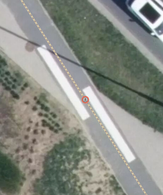
Unfortunately, I can’t see anything on the picture. You can always add eg. crossing:markings=zebra. It would always apply to footways in Poland so should be enough.
For more complicated cases You can use cycleway:crossing:markings=* and footway:crossing:markings=* to show more details. There are a lot of crossings tags, there may be even something more useful, I don’t know about, but I think this is enough to show a crossing with details.
Of course, in difficult cases I don’t see a problem to split the road. But the spliting should be as short as possible, I would say that splitting 500 meters of a road, because there is one difficult crossing is an overkill.
I would say the same for car roads to be honest. If there is a difficult situation, which is difficult to map with one way - sure, split the road in the difficult place. I see that a lot with junctions, especially the bigger ones… But the split happens on junction, not 500 meters before it.
The examples show car roads, but I don’t see anything on the desciption that in can’t be used like that. It just specify how the marking looks. Maybe there is somebody wiser that would tell it’s not correct. We still use highway:crossing no matter if we split ways or not, so I don’t see why we can’t use detailed tags related to it.
I don’t want this comment to be ignored, but I don’t know how to respond. It doesn’t add anything to the discussion.
It seems if there is a legitimate need to split at one point, you’re saying splitting is only ok for the distance necessary to achieve exactly what cannot be achieved by a single line.
Apologies if I didn’t understand that correctly.
But why so? If I wanted to map the pavement using a separate line, would you delete it? (like here)
I apologise. As I said before, I can’t see a thing in the picture so I can’t give You an exact answer. There is a possibility is there is no answer, I have never denied that some intances would need split on the junction.
It seems to be about sidewalk next to road which I’m pretty sure I have already mentioned. It’s worth to mention that many people there listed problems with separated lanes there. I have seen some photos on one of the comments - looks like a normal raised sidewalk to me.
I would just add crossing:markings=zebra. In Poland zebra would always be used for pedestrian crossing, so this would be enough to understand that footway crossed cycleway.
So, routing infoms the pedestrian that they have to yeld to cyclists there?
I reming you that in Poland, a zebra crossing shape is defined by law and what you see is not it. Even if it was, a crossing sign on a pole is not present as well and it’s required for a marked uncontrolled crossing.
So again, what do you tag for the node so routing knows pedestrians have to yeld to cyclists in this spot?
It should work the same as “normal” car crossing. I don’t know any navi working that precise, but if that navi exists than, yes, it should work.
I don’t understand what You are trying to do then. You wanted to split roads to show which road crossed which. Now You are saying that those crossings are not really crossings, and there are unmarked. In this case I don’t see why split the roads if the crossings are fictional anyway.
If they are unmarked just tag them as unmarked, but I don’t understand the whole fuss in this case.
the road is designed there, so cycling and pedestrian traffic has to cross there, so it it has to be mapped,. Same as you map a crossing over a street for cars, so when you’re going 90km/h you get a warning in time to be creful and yeld if its uncontrolled crossing.
type of crossing is also information for pedestrians.
logically cyclists need it as well
and if cycling traffic crosses with sidewalk, there has to be a clear information.
I didn’t ask you to split roads like you imply. I asked you to tell what you tag over a single line, so it is a clear information and not a gueswork for a routing company who wants to navigate their consumers solely based on OSM data input.
If you can prove it’s actually possible, you have proven this one case within the other issues i have described.
Or we can keep telling all is fine and do whatever, so those routing companies can do whatever as well.
Sorry, I will end here, I don’t understand your reasoning. Even on the Wiki see You can clearly see that in the examples that combination of crossing=uncontrolled and crossing:markings=zebra is normal. https://wiki.openstreetmap.org/wiki/Tag:crossing=uncontrolled
But if I understand correctly the crossing is not there in “legal” sense and zebra is not there too, so just use uncontrolled and unmarked. I don’t know what else You want there.
I think You should step back and think what You are really want to show and check if maybe the answer is already there - in the Wiki or forum.
Oh well, believe me, I tried to do my best for you to describe precise tagging over a one-lined infrastructure.
If you need to step back, because you can’t find it anywhere on the wiki or you don’t feel like you can think anything for a proposal of future tagging, that’s okey, just leave it to people who can.