Vielen lieben Dank. Damit funzt es.
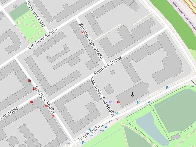
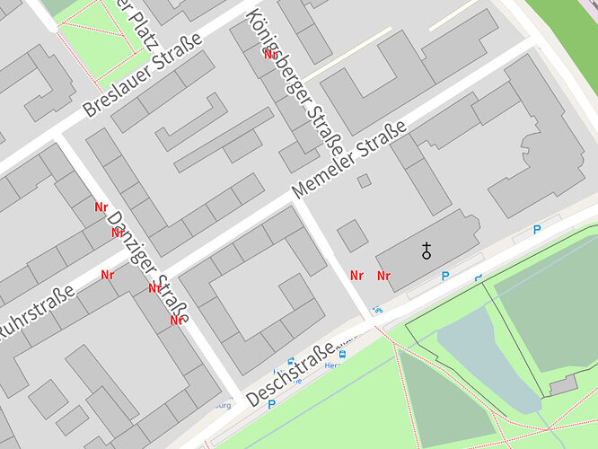
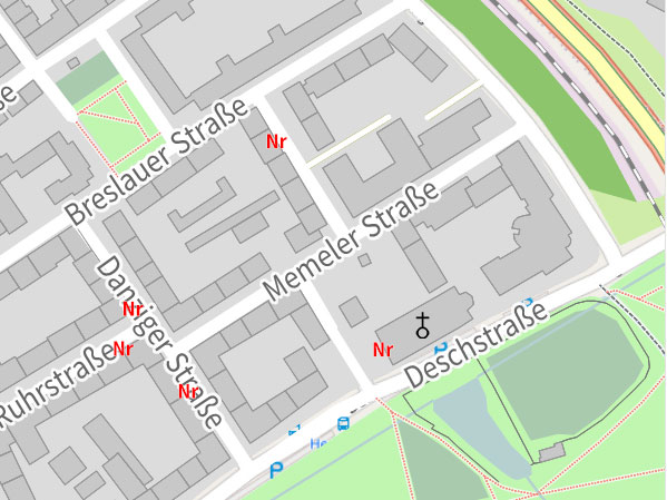
Allerdings steht dei Beschriftung stets etwas abseits unter den “nodes”. Sicher lässt sich auch steuern, dass der Text vertikal und horizontal zentriert auf der genauen Position zu stehen kommt?
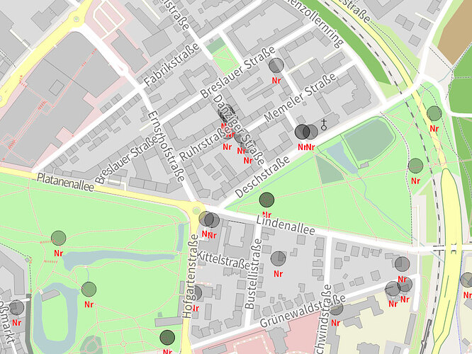
Und dann bleibt noch meine Irritation wegen der Farben. Ich habe die “features” Kunstobjekte, Fassadenkunst und Brunnen differenziert mit Begriffen aus “description” definiert. In den rules habe ich den “targets” dann “text-color : black” bzw. red und blue zugewiesen. Dargestellt werden alle 3 Kategorien jedoch in red. Was mache ich falsch?
// Default rendering rules for Maperitive resembling that of OSM Mapnik
// http://maperitive.net
// Created by Igor Brejc
// Released under the Creative Commons Attribution-ShareAlike 3.0 License (http://creativecommons.org/licenses/by-sa/3.0/)
// Updates by Michael <quelbs_at_gmail.com>
// Icons used: Map icons CC-0 from SJJB Management (http://www.sjjb.co.uk/mapicons)
features
points, areas
// parking : amenity=parking
// postbox : amenity=post_box
// postoffice : amenity=post_office
// telephone : amenity=telephone
// fire station : amenity=fire_station
// police station : amenity=police
// hospital : amenity=hospital
// recycling : amenity=recycling
// fassadenkunst : artwork_type=fassade
// kunstobjekte : artwork_type=objekt
// brunnen : artwork_type=brunnen
kunstobjekte : @ismatch(description, ".*Stadtkunst*")
fassadenkunst : @ismatch(description, ".*Stadtkunst*") AND @ismatch(description, ".*Fassade*") // AND (artwork_type=sculpture OR artwork_type=stone OR artwork_type=mural)
// fassadenkunst : @ismatch(description, ".*Stadtkunst Fassade*")
brunnen : @ismatch(description, ".*Stadtkunst*") AND amenity=fountain
church : amenity=place_of_worship AND religion=christian
// drinking water : amenity=drinking_water
// bank : amenity=bank
// atm : amenity=atm
// toilets : amenity=toilets
// library : amenity=library
// tree : natural=tree
school : amenity=school
// bus stop : highway=bus_stop
// railway station : railway=station
// mini roundabout : highway=mini_roundabout
// gate : barrier=gate
// tourism viewpoint : tourism=viewpoint
// tourism hotel : tourism=hotel
// tourism museum : tourism=museum
// amenity pub : amenity=pub
// amenity fast_food : amenity=fast_food
// aerodrome : aeroway=aerodrome
// housenumber : [addr:housenumber]
// These are not shown on Mapnik
// puffin : crossing_ref=puffin
memorial : historic=memorial
areas
beach : natural=beach
building : building AND NOT building=no
water : natural=water OR waterway=riverbank OR landuse=reservoir OR landuse=basin or waterway=dock
village green : landuse=village_green
forest : landuse=forest OR natural=wood
farm : landuse=farm
farmyard:landuse=farmyard
grass : landuse=grass
fell : natural=fell
glacier : natural=glacier
national park : boundary=national_park
allotments : landuse=allotments
academic : node[@isOneOf(amenity, university, college, school)] area[@isOneOf(amenity, university, college, school)]
meadow : natural=meadow OR landuse=meadow
nature reserve : leisure=nature_reserve
playground : leisure=playground
// car park: amenity=parking
track : leisure=track
graveyard : amenity=grave_yard OR landuse=cemetery
military : landuse=military OR military=barracks
park : leisure=park
leisure garden : leisure=garden
leisure pitch : leisure=pitch
leisure stadium : leisure=stadium
landuse retail : landuse=retail
landuse industrial : landuse=industrial
commercial area : landuse=commercial
residential area : landuse=residential
aeroway apron : aeroway=apron
aeroway terminal : aeroway=terminal
highway pedestrian : highway=pedestrian
orchard : landuse=orchard
farmland : landuse=farmland
quarry : landuse=quarry
lines
oneway : oneway=yes OR oneway=true OR oneway=-1
coastline : natural=coastline
river : waterway=river
stream : waterway=stream
canal : waterway=canal
drain : waterway=drain
dock : waterway=dock
railway rail : railway=rail
railway lightrail : railway=light_rail
platform : railway=platform OR public_transport=platform
line barrier : barrier=wall OR barrier=fence
highway motorway : highway=motorway OR (highway=construction AND construction=motorway)
highway motorway link : highway=motorway_link OR (highway=construction AND construction=motorway_link)
highway trunk : highway=trunk OR (highway=construction AND construction=trunk)
highway trunk link: highway=trunk_link OR (highway=construction AND construction=trunk_link)
highway primary link : highway=primary_link OR (highway=construction AND construction=primary_link)
highway primary : highway=primary OR (highway=construction AND construction=primary)
highway secondary : highway=secondary OR (highway=construction AND construction=secondary)
highway tertiary : highway=tertiary OR (highway=construction AND construction=tertiary)
highway unclassified : highway=unclassified OR (highway=construction AND construction=unclassified)
highway residential : highway=residential OR (highway=construction AND construction=residential)
highway living_street : highway=living_street OR (highway=construction AND construction=living_street)
highway construction : highway=construction
highway service : highway=service
highway pedestrian : highway=pedestrian
highway track : highway=track
highway footway : highway=footway
highway cycleway : highway=cycleway
highway path : highway=path
highway access private : access=private AND highway
highway access destination : access=destination AND highway
highway steps : highway=steps
pier : man_made=pier
bridge foot : bridge=yes AND (foot=yes OR highway=footway)
historic citywalls : historic=citywalls OR historic=city_wall
// power_line : power=line OR power=minor_line
aerialway closed: @isOneOf(aerialway,cable_car,gondola,mixed_lift)
aerialway open: @isOneOf(aerialway,chair_lift,drag_lift)
aeroway runway : aeroway=runway
aeroway taxiway : aeroway=taxiway
boundary country : boundary=administrative AND (admin_level=2 OR admin_level=4) AND NOT natural=coastline
boundary province : boundary=administrative AND admin_level=6
boundary municipal : boundary=administrative AND admin_level=8
contour major : contour[@isMulti(elevation, 100)]
contour minor : contour[@isMulti(elevation, 20) and not @isMulti(elevation, 100)]
gps tracks : gpstrack[]
gps routes : gpsroute[]
// Routes
// route ncn : relation[type=route AND route=bicycle AND network=ncn]
route byway : relation[type=route AND route=bicycle AND network="National Byway"]
route foot : relation[type=route AND route=foot]
points
// place city : place=city
place town : place=town
place village : place=village
place hamlet : place=hamlet
// place locality: place=locality
place isolated_dwelling : place=isolated_dwelling
place suburb : place=suburb
// diy : shop=doityourself
// hair dresser : shop=hairdresser
// supermarket : shop=supermarket
// convenience : shop=convenience
// bakery : shop=bakery
// restaurant : amenity=restaurant
// cafe : amenity=cafe
// pharmacy : amenity=pharmacy
// peak : natural=peak
// powertower : power=tower OR power=pole
// info : information=guidepost
// bollard : barrier=bollard
// lift_gate : barrier=lift_gate
// aerialway station : aerialway=station
// motorway_junction : highway=motorway_junction
gps waypoints : gpswaypoint[]
gps trackpoints: gpstrack[].gpspoint[]
gps routepoints: gpsroute[].gpspoint[]
properties
map-background-color : #F1EEE8
map-background-opacity : 1
map-sea-color : #B5D0D0
font-weight : normal
font-family : Source Sans Pro
text-max-width : 7
text-halo-width : 25%
text-halo-opacity : 0.5
text-align-horizontal : center
text-align-vertical : center
font-stretch : 0.9
map.rendering.lflp.min-buffer-space : 5
map.rendering.lflp.max-allowed-corner-angle : 40
rules
target: gps tracks
define
line-color : red
line-opacity : 0.75
min-zoom : 5
line-width : 5
draw : line
target: gps routes
define
line-color : blue
line-opacity : 0.75
line-style : dash
min-zoom : 5
line-width : 5
draw : line
target : gps waypoints
define
shape : circle
shape-size : 8
line-color : green
fill-opacity : 0
draw : shape
target : gps trackpoints
define
min-zoom : 17
shape : square
shape-size : 10
line-color : green
line-width : 1
fill-opacity : 0
draw : shape
target : gps routepoints
define
min-zoom : 12
shape : diamond
shape-size : 10
line-color : green
line-width : 1
fill-opacity : 0
draw : shape
target : $featuretype(point)
if : place*
define
font-weight : bold
text-max-width : 1000
text-align-horizontal : near
if : *city
define
font-size : 6:8;14:20
min-zoom : 6
max-zoom : 14
placement-value : 1000
elseif : *town
define
font-size : 9:8;12:12;20:20
text : @up(name)
min-zoom : 9
placement-value : 20
elseif : *village
define
font-size : 12:12;20:20
min-zoom : 12
text-color : white black 50%
placement-value : 1
elseif : *hamlet
define
font-size : 14:8;20:16
min-zoom : 14
placement-value : 0.1
elseif : *locality
define
font-size : 14:8;20:16
min-zoom : 14
placement-value : 0.1
elseif : *isolated_dwelling
define
font-size : 15:8;20:14
min-zoom : 15
placement-value : 0.1
elseif : *suburb
define
font-size : 12:12;20:20
min-zoom : 12
text-color : white black 50%
placement-value : 10
draw : text
if : aerialway station
define
min-zoom:12
shape:square
shape-size:12:3;16:8
fill-color:#7981B0
line-style:none
text-offset-vertical:120%
text-color:#8888FF
draw:shape
// draw : text
target : housenumber
define
min-zoom : 17
text : [[addr:housenumber]]
text-halo-width : 0
font-size : 8
placement-value : 0.01
draw : text
target : playground
define
fill-color : #A9CAAE
line-style : none
draw : fill
define
line-color : #ADCCB5
line-width : 1
draw : line
define
min-zoom : 17
placement-value : 0.05
// draw : text
target : $featuretype(area)
define
line-style : none
line-width : 1
if : forest
define
min-zoom : 9
fill-color : #8DC56C
elseif : beach
define
min-zoom : 10
fill-color : #FEFEC0
elseif : farm
define
min-zoom : 9
fill-color : #E9D8BD
elseif : farmyard
define
min-zoom : 9
fill-color : #DCBE91
elseif : fell
define
fill-color : #C5FF5B black 10%
elseif : water
define
fill-color : #B5D0D0
elseif:academic
define
fill-color : #F0F0D8
line-color : #E5D2CC
line-style : solid
elseif : residential area
define
fill-color : #DCDCDC
elseif : grass
define
fill-color : #CFECA8
elseif : allotments
define
fill-color : #C8B084
elseif : meadow
define
fill-color : #CFECA8
elseif : nature reserve
define
fill-color : #ABDE96
elseif : car park
define
fill-color : #F6EEB7
elseif : park
define
fill-color : #C0F6B0
elseif : leisure garden
define
fill-color : #CFECA8
elseif : graveyard
define
fill-color : #A9CAAE
elseif : building
define
fill-color : #c8c8c8
elseif : leisure pitch
define
fill-color : #89D2AE
elseif : leisure stadium
define
fill-color : #33CC99
elseif : track
define
fill-color : #74DCBA
elseif : village green
define
fill-color : #CFECA8
elseif : landuse retail
define
fill-color : #F0D9D9
line-color : #F4A19E
draw : line
elseif : landuse industrial
define
fill-color : #DFD1D6
elseif : commercial area
define
fill-color : #EFC8C8
elseif : military
define
fill-color : #FE9898
elseif : aeroway*
define
fill-color : #E9D1FE
elseif : orchard
define
fill-color : #9fd790
elseif : farmland
define
fill-color : #e9d8be
elseif : aerodrome
define
fill-color : #e9e8e3
line-style : solid
line-color : #b3b3b0 black 10%
elseif : quarry
define
fill-color : white
line-style : solid
line-color : #b3b3b0 black 10%
fill-hatch : diagonalcross
fill-hatch-color : #cccccc
elseif : glacier
define
fill-color : #DDECEC
line-style : dash
line-color : #DDECEC black 10%
elseif : *pedestrian
for : area
define
min-zoom : 14
fill-color : #EDEDED
line-color : #B1B1B1 black 20%
line-style : solid
else
stop
draw : fill
if : building
define
min-zoom : 15
line-style : solid
line-width : 1
line-color : #969696
draw : line
for : amenity=hospital
stop
define
min-zoom : 17
if:academic
define
min-zoom:16
// draw : text
// aeroway taxiway : aeroway=taxiway
// aeroway apron : aeroway=apron
// aeroway terminal : aeroway=terminal
target : aeroway runway
define
min-zoom : 11
line-color : #BBBBCC
line-width : 11:2;15:20
draw : line
target : aeroway taxiway
define
min-zoom : 11
line-color : #BBBBCC
line-width : 11:1;15:6
draw : line
target : glacier
define
min-zoom : 10
text-color : #A3A3FE
draw : text
target : boundary*
define
line-color : #9E1A99
line-opacity : 0.5
if : boundary country
define
line-width : 6:1;9:3;10:6
elseif : boundary province
define
min-zoom : 4
line-width : 4:1;11:3
line-style : dash
elseif : boundary municipal
define
min-zoom : 12
line-width : 12:1;14:2
line-style : dash
draw : line
target : national park
define
fill-color : #8DC56C
fill-opacity : 0.2
line-style : none
draw : fill
define
line-color : #8DC56C black 20%
line-opacity : 0.5
line-width : 3
line-style : dash
font-size : 3:3;12:12
text-color : green
font-weight : normal
draw : line
draw : text
target : peak
define
shape : triangle
shape-size : 12
fill-color : #D08F55
line-style : none
min-zoom : 11
draw : shape
define
text : @if(name, name @if(ele, "\n(" ele ")"), ele)
text-color : #ae4242
min-zoom : 13
font-size : 10
text-max-width : 10
text-offset-vertical : 100%
text-align-vertical : near
// draw : text
target : info
define
min-zoom : 16
text : "i"
text-color : #734A08
font-size : 20
font-family : Times New Roman
text-halo-width : 0
// draw : text
target : lift_gate
define
min-zoom : 16
shape : custom
shape-def : f:#3E3E3E;p:#3E3E3E;-1,1;-1,-3;-3,-3;-3,3;-1,3;-1,2;4,2;4,1;Z
shape-size : 14:7;20:12
line-width : 1
draw : shape
target : bollard
define
min-zoom : 16
fill-color : #7D7D7D
line-style : none
shape-size : 16:1;18:2
draw : shape
target : powertower
define
min-zoom: 14
shape : custom
shape-def : m:-1,1;l:1,1,1,-1,-1,-1,-1,1,1,-1;m:-1,-1;l:1,1
shape-size : 14:2;20:9
line-width : 1
draw : shape
target : power_line
define
min-zoom: 16
line-width: 1
line-color : #5c5c5c white 50%
for : power=line
define
line-color : #5c5c5c
min-zoom : 14
line-width: 1
draw : line
target:aerialway *
define
min-zoom:12
line-width:1
line-style:solid
line-color:#999
draw:line
draw : text
target:aerialway closed
define
min-zoom:12
shape:circle
shape-size:1
shape-spacing:20
draw:shape
target:aerialway open
define
min-zoom:12
shape:custom
shape-def:l:0,1,0,-1
shape-spacing:5
shape-size:3
line-width:1
draw:shape
target : platform
define
min-zoom : 13
line-color : gray
line-width : 3
draw : line
target : railway rail
define
min-zoom : 13
line-style : dashlong
line-color : white
line-width : 2
border-style : solid
border-color : gray
border-width : 25%
draw : line
define
min-zoom : 6
max-zoom : 13
line-style : none
line-color : white black 30%
line-width : 6:1;8:1;12:1.5
draw : line
target : railway*
define
min-zoom : 13
line-color : gray
line-width : 2
draw : line
define
min-zoom : 15
text-align-horizontal : center
text-align-vertical : center
draw : text
target : highway access*
define
min-zoom : 13
line-width : 13:1;15:2;18:4
line-style : dash
line-color : #F7D4D4
for : access=destination
define
line-color : lightblue white 50%
draw : line
target : highway construction
define
min-zoom : 13
line-width : 13:2;15:4;18:10
line-style : solid
line-color : white
for : construction=tertiary OR construction=secondary OR construction=primary
define
line-color : white
draw : line
target : motorway_junction
define
font-size : 11
min-zoom : 13
text-color : #849BBD
text-halo-width : 25%
text-offset-vertical : 150%
// draw : text
target : highway*
define
min-zoom:14
text:name
text-halo-width:20%
font-size:15:10;16:14;17:30
text-color : #646464
draw : text
for : oneway=yes OR oneway=true
define
min-zoom : 20
shape : custom
shape-def : 60,0,20,-40,20,-15,-60,-15,-60,15,20,15,20,40;Z
shape-size : 12
shape-aspect : 0.75
shape-spacing : 6
fill-color : #6C70D4
line-style : none
for : oneway=-1
define
angle : 180
draw : shape
define
line-style : solid
line-join : round
line-start-cap : round
line-end-cap : round
if : *motorway*
if : *link
define
line-width : 7:1;12:3;13:4;16:5;18:6
else
define
line-width : 7:1;9:2;12:3;13:7;16:10;18:12
define
min-zoom : 12
line-color : #849BBD
border-style : solid
border-color : #849BBD black 20%
border-width : 15%
draw : line
define
min-zoom : 7
max-zoom : 12
border-style : none
draw : line
define
min-zoom : 10
max-zoom : 20
font-family : Source Sans Pro
text-align-horizontal : center
text-align-vertical : center
text : ref
text-color : #fcfcfb
text-halo-width : 0
shape : custom
shape-def : p:#809bc0;pw:5;f:#809bc0;m:-10,-10;l:10,-10;a:10,10,10,10;l:-10,10;a:10,10,-10,-10;z;p:#fcfcfb;pw:2;m:-10,-10;l:10,-10;a:10,10,10,10;l:-10,10;a:10,10,-10,-10;z
shield-padding-left : 5
shield-padding-right : 5
shield-padding-top : 7
shield-padding-bottom : 7
shield-resize-mode : free
// draw : shield
elseif : *trunk*
define
min-zoom : 12
line-color : #FEFEB2
line-width : 11:1;13:2;15:10;18:12
border-style : solid
border-color : #96D296 black 20%
border-width : 15%
for : tunnel=yes
define
border-style : dot
draw : line
define
min-zoom : 7
max-zoom : 12
border-style : none
draw : line
elseif : *primary*
define
min-zoom : 11
line-color : #FEFEB2
line-width : 11:2;12:2;15:10;18:12
border-style : solid
border-color : #ECA2A3 black 20%
border-width : 15%
for : tunnel=yes
define
border-style : dot
draw : line
define
min-zoom : 7
max-zoom : 11
border-style : none
draw : line
define
min-zoom : 13
max-zoom : 20
// draw : text
elseif : *secondary
define
min-zoom : 12
line-color : #FEFEB2
line-width : 10:1;11:2;13:2;15:10;18:12
border-style : solid
border-color : #CAA36F
border-width : 5%
for : tunnel=yes
define
border-style : dot
for : bridge=yes
define
border-color : #000
border-width : 8%
draw : line
define
min-zoom : 8.5
max-zoom : 12
border-style : none
draw : line
define
min-zoom : 13
max-zoom : 20
// draw : text
elseif : *tertiary
define
min-zoom : 13
line-color : white
line-width : 10:1;13:2;15:10;18:12
border-style : solid
border-color : #FEFEB2 black 20%
border-width : 15%
for : tunnel=yes
define
border-style : dot
for : bridge=yes
define
border-color : #000
draw : line
define
min-zoom : 10
max-zoom : 13
line-color : white black 25%
border-style : none
draw : line
define
min-zoom : 10
max-zoom : 20
// draw : text
elseif : *service
define
min-zoom : 13
line-color : white
line-width : 12:0.5;13:1;15:3;18:5
border-style : solid
border-color : #FEFEB2 black 20%
border-width : 15%
for : tunnel=yes
define
border-style : dot
for : bridge=yes
define
border-color : #000
draw : line
// draw : text
elseif : *pedestrian
for : not area
define
min-zoom : 10
line-color : white
line-width : 7:0.6;9:1;10:1.2;12:2.5;13:3;16:5;18:6
border-style : solid
border-color : #B1B1B1 black 20%
border-width : 15%
for : tunnel=yes
define
border-style : dot
for : bridge=yes
define
border-color : #000
draw : line
// draw : text
elseif : $regex("(.*residential)|(.*unclassified)")
define
min-zoom : 13
line-color : white
line-width : 12:1;13:1.5;15:4;18:10
border-style : solid
border-color : white
border-width : 15%
for : tunnel=yes
define
border-style : dot
for : bridge=yes
define
border-color : #000
draw : line
define
min-zoom : 10
max-zoom : 13
border-style : none
line-color : white black 25%
draw : line
define
min-zoom : 10
max-zoom : 20
// draw : text
elseif : *living_street
define
min-zoom : 13
line-color : white
line-width : 12:1;13:1.5;15:4;18:10
border-style : none
for : tunnel=yes
define
border-style : dot
for : bridge=yes
define
border-color : #000
draw : line
define
min-zoom : 10
max-zoom : 20
// draw : text
elseif : *track
define
min-zoom : 12.5
line-color : #9D7517
line-width : 12.5:0.3;13:0.5;15:1;18:1.5
line-style : solid
border-style : solid
border-color : white
border-width : 100%
border-opacity : 0.3
for : tracktype=grade1
define
line-style : solid
line-width : 12.5:0.5;13:1;15:1.5;18:2
for : tracktype=grade2
define
line-style: dashlong
for : tracktype=grade3
define
line-style: dash
for : tracktype=grade4
define
line-style: dashdot
for : tracktype=grade5
define
line-style: dashdotdot
for : tunnel=yes
define
border-style : dot
for : bridge=yes
define
border-color : #000
draw : line
// draw : text
elseif : *footway
define
min-zoom : 13
line-color : #F68474
line-width : 13:0.5;15:1;18:1.5
line-style : dot
border-style : solid
border-color : white
border-width : 100%
border-opacity : 0.3
for : tunnel=yes
define
border-style : dot
for : bridge=yes
define
border-color : #000
draw : line
// draw : text
elseif : *cycleway
define
min-zoom : 13
line-color : blue
line-width : 13:0.5;15:1;18:1.5
line-style : dot
border-style : solid
border-color : white
border-width : 100%
border-opacity : 0.3
for : tunnel=yes
define
border-style : dot
for : bridge=yes
define
border-color : #000
border-opacity : 1
draw : line
// draw : text
elseif : *path
define
min-zoom : 13
line-color : #6E7C6D
line-width : 13:0.5;15:1;18:1.5
line-style : dash
border-style : solid
border-color : white
border-width : 100%
border-opacity : 0.3
for : tunnel=yes
define
border-style : dot
for : bridge=yes
define
border-color : #000
draw : line
// draw : text
else
stop
target : highway steps
define
min-zoom : 16
shape : custom
shape-def : -1,1, -1,-1, 1,-1, 1,1;Z
shape-spacing : 2
shape-size : 16:1;20:3
shape-aspect : 3
fill-color : #F98072
line-style : none
draw : shape
target : pier
define
line-color : #F1EEE8
line-width : 1:1;20:8
draw : line
target : line barrier
define
min-zoom : 13
line-color : black
line-width : 1
for:barrier=fence
define
min-zoom:16
line-color:#777
draw : line
target : bridge foot
define
min-zoom : 13
line-color : white
line-width : 7:0.6;9:1;10:1.2;12:2.5;13:3;16:5;18:6
border-style : solid
border-color : #FEFEB2 black 20%
border-width : 15%
draw : line
draw : text
target : historic citywalls
define
min-zoom : 13
line-color : #8D968D
line-width : 7:0.6;9:1;10:1.2;12:2.5;13:3;16:10
draw : line
draw : text
define
target : river
define
line-color : #B5D0D0
line-width : 7:1;12:2;14:5
draw : line
define
min-zoom:13
font-size:13:8;16:20
text-color:#649ed0
text-halo-width : 0%
font-weight:normal
draw : text
target : stream
define
line-color : #B5D0D0
line-width : 13:1;15:2
draw : line
define
min-zoom:13
font-size:13:8;16:12
text-color:#B5D0D0
font-weight:normal
draw : text
target : canal
define
min-zoom : 12
line-color : #B5D0D0
line-width : 12:1;17:8
draw : line
define
min-zoom:13
font-size:13:8;16:12
text-color:#B5D0D0
font-weight:normal
draw : text
target : drain
define
min-zoom : 13
line-color : #B5D0D0
line-width : 1
draw : line
target: parking
define
icon-image : icons/SJJB/png/transport_parking.p.32.png
min-zoom : 15
icon-width : 16
// draw : icon
target: bus stop
define
icon-image : icons/SJJB/png/transport_bus_stop.p.32.png
min-zoom : 15
icon-width : 15:10;18:16
draw : icon
target: railway station
define
min-zoom : 12
shape : square
line-color : #7981B0
fill-color : #7981B0
shape-size : 12:5;18:8
draw : shape
define
min-zoom : 14
font-size : 12
text-color : #7981B0
text-offset-vertical : -150%
draw : text
target: postbox
define
icon-image : icons/SJJB/png/amenity_post_box.p.32.png
min-zoom : 16
icon-width : 16
draw : icon
target: postoffice
define
icon-image : icons/SJJB/png/amenity_post_office.p.32.png
min-zoom : 16
icon-width : 16
draw : icon
target: telephone
define
icon-image : icons/SJJB/png/amenity_telephone.p.32.png
min-zoom : 16
icon-width : 16
draw : icon
target: fire station
define
icon-image : icons/SJJB/png/amenity_firestation.p.32.png
min-zoom : 16
icon-width : 16
draw : icon
target: hospital
define
icon-image : icons/SJJB/png/health_hospital.p.32.png
min-zoom : 15
icon-width : 16
draw : icon
define
min-zoom : 16
text-offset-vertical : 150%
text-color : #DA0092
draw : text
target: police station
define
icon-image : icons/SJJB/png/amenity_police.p.32.png
min-zoom : 16
icon-width : 16
draw : icon
target: cafe
define
icon-image : icons/SJJB/png/food_cafe.p.32.png
min-zoom : 16
icon-width : 16
draw : icon
target: recycling
define
icon-image : icons/SJJB/png/amenity_recycling.p.32.png
min-zoom : 16
icon-width : 16
draw : icon
target: supermarket
define
icon-image : icons/SJJB/png/shopping_supermarket.p.32.png
min-zoom : 16
icon-width : 16
draw : icon
target: diy
define
icon-image : icons/SJJB/png/shopping_diy.p.32.png
min-zoom : 16
icon-width : 16
draw : icon
target: convenience
define
icon-image : icons/SJJB/png/shopping_convenience.p.32.png
min-zoom : 16
icon-width : 16
draw : icon
target: mini roundabout
define
icon-image : icons/SJJB/png/transport_roundabout_anticlockwise.p.32.png
min-zoom : 16
icon-width : 9
draw : icon
// ###################################################################################
target: fassadenkunst
define
icon-image : icons/web/point.png
min-zoom : 16
icon-width : 10
font-weight : bold
font-size : 20
text-color : black
text-halo-width : 0%
text-offset-vertical : 150%
text : ref
text-avoid-overlaps : false
define
shape : circle
shape-size : 15
line-color : black
line-width : 1
fill-color : black
fill-opacity : 50%
draw : shape
draw : text
// draw : icon
target: kunstobjekte
define
icon-image : icons/web/point.png
min-zoom : 16
icon-width : 24
font-weight : bold
text-color : red
font-size : 20
text-halo-width : 5%
text : ref
text-offset-vertical : 150%
text-avoid-overlaps : false
define
shape : circle
shape-size : 15
line-color : black
line-width : 1
fill-color : black
fill-opacity : 50%
draw : shape
draw : text
// draw : icon
target: brunnen
define
icon-image : icons/web/point.png
min-zoom : 16
icon-width : 24
font-weight : bold
text-color : blue
font-size : 20
text-halo-width : 5%
text-offset-vertical : 150%
text : ref
text-avoid-overlaps : false
define
shape : circle
shape-size : 15
line-color : black
line-width : 1
fill-color : black
fill-opacity : 50%
draw : shape
draw : text
// draw : icon
target: church
define
icon-image : icons/web/churchMP.png
min-zoom : 16
icon-width : 24
define
text-offset-vertical : 150%
// draw : text
draw : icon
target: memorial
define
icon-image : icons/web/memorialMP.png
min-zoom : 16
icon-width : 12
// draw : icon
target : amenity*
define
min-zoom : 20
text-color : #856951
text-offset-vertical : 150%
// draw : text
define
min-zoom : 16
icon-width : 16
if : *pub
define
icon-image : icons/SJJB/png/food_pub.p.32.png
elseif : *fast_food
define
icon-image : icons/SJJB/png/food_fastfood2.p.32.png
else
stop
draw : icon
target: contour*
define
line-color : #7f3300
line-opacity : 0.35
curved : true
if : *major
define
map.rendering.contour.label : true
min-zoom : 9
line-width : 11:0.1;11.9:1;12:2
font-size : 10
font-style : italic
font-weight : normal
text-halo-width : 35%
text-halo-opacity : 1
text-halo-color : #F1EEE8
else
define
min-zoom : 12
line-width : 1
draw : contour
target: coastline
define
line-color : #B5D0D0
line-width : 2
draw : line


