Manhattan Community Boards as administrative boundaries

Power is the wrong metric to measure. Every town in Indiana is more powerful than the township it’s in. Plenty of private landowners have more power than their local officials. As noted in the report I cited earlier, community board members and district managers are city officials.[1] Let’s stop comparing them to HOAs.

The city charter mentions “community district” 105 times and “community board” 173 times, usually in the same breath as “borough”. This is what I meant by “remit”. Here are some examples that illustrate the city–borough–community district hierarchy (emphasis mine):

Plans for the development, growth, and improvement of the city and of its boroughs and community districts may be proposed by … (5) a borough board with respect to land located within its borough, or (6) a community board with respect to land located within its community district.

conduct an annual comprehensive youth services needs assessment on a citywide, boroughwide and community district basis

The districts are defined in chapter 69. Say what you want about the boards lacking plenary authority, but on paper, they seem to matter more than a few states’ counties.

Granted, the boundaries of these districts don’t seem to be observable on the spot. However, their existence is verifiable. Aside from the map mural that I mentioned earlier, each board’s offices are prominently signposted, and here’s some street furniture that can tell you the community district you’re in:

Granted, people don’t express their location in terms of community districts or boards nearly as often as they express their location in terms of neighborhoods. It does happen, for example:

Across Eighth Avenue in community district 5, which covers most of Midtown, there are now 12 hotels housing the homeless — more than any other area in the city.

If you want to argue that the districts should be place points rather than boundaries due to the strictest possible application of the on-the-ground rule, or if you want to argue that regardless these are formalities that locals are apathetic about, then I think that would be more convincing than nitpicking over the boards’ bylaws or minutes.

Many of the admin_level=9 and 10 boundaries in the U.S. are far more questionable than the New York community districts in my opinion. I have successfully pushed for the deletion of quite a few such boundaries. We can spin off other threads about other cities if you want.

What’s a good example of a city division system that should be mapped as administrative boundaries, so we can compare the community districts against that standard?


  1. A district manager is appointed by the community board, akin to a city council appointing a city manager. ↩︎

1 Like

The OSM depiction in California (4) is rough below 8, despite what sometimes seems a large task of continuing education (within OSM, about good admin_level tagging). What I mean by this is California seems to utter into OSM “darn good” data down to the level of 8, and then at 9 and 10 it gets wonky in both the LA Basin and the Bay Area. Some of this wonkiness is understandable confusion between tagging and what we mean by admin_level, some of this appears to be “assertive tagging” (something akin to “neighborhood graffiti tagging.”) Let’s call it misunderstanding and vow to improve.

It sometimes feels like slow and sticky molasses to unravel this (these, as this is a “replicated” problem). I find that taking time to get the snarl untangled pays dividends. No particular rush on these, they are snarly and take time to unravel.

I have seen them unravel, I have seen them take time to unravel before they finally unravel. Let’s slow this bird down, I’d be OK with that.

The USA looks pretty good down to 8 and at 9 and 10 it can get fuzzy, but we’re on it.

Brian’s opinion: boroughs of Montreal, as described by Wikipedia:

I actually searched quite a bit for other examples and found many many community outreach boards/districts/zones that at a cursory glance seemed to be similar in nature to how I’ve characterized the NYC boards, in both big and small cities respectively. I say “similar” meaning, had defined boundaries, designed for citizen engagement, and an advisory role. Two big-city examples that had the most formal entities that I found were Washington, DC and Chicago. I also found a district/neighborhood system in Portland, OR that is worth investigating. It’s a longer research project than can be done from cursory review.

If we extend boundary=administrative to the NYC boards, I maintain that it opens to door to citizen engagement districts anywhere. Here’s a random example, Jacksonville, Florida planning districts.

My objection to mapping citizen engagement districts en masse into the boundary=administrative hierarchy as a general case is that they mean something different from the places that we tag admin_level values 2 through 8. As a data consumer of bounded places, I think it’s important to draw a distinction between primary, general-purpose political boundaries from other things.

My current thinking is these belong in a separate boundary=* value specific to citizen engagement districts. It would give better clarity to data consumers that someone on the ground may not recognize the district with the same sense of primacy that goes with knowing what city, county, state, and country that they’re standing in.

I’m all for clarity, though elusive it may be. If something is clearly administrative (that seems difficult to utter at this hyperlocal level, different than 2/4/6/8 country-state-county-city), below city, it really should get 9 or 10 — especially if there are clearly stated boundaries (say, by a city council). I think what we’re doing here is postulating / discussing what some of those criteria are, which is good. We shouldn’t dismiss these because “we did this in NYC (let’s say) and that opened it up across the country…” as that would stifle / suppress real data from entering OSM in the name of “mmm, no, too clutter-inducing, inconvenient, controversial or maybe difficult to reach consensus on whether it is or isn’t (one of these).” That’s ignoring real data and we can do better.

If 9s and 10s exist, they exist, and should enter our database. The hard part seems to be agreeing that such hyperlocal versions of things “rises to our definition of administrative.” That’s going to be messy dialog and we should boldly embrace that fact, rather than try to hose it off into a bitbucket while we stick our fingers in our ears and say la-la-la.

I’m OK with “opening the door” to (certain kinds of) “districts anywhere” (well, in the USA). But “certain kinds of” really need to be administrative. Considering how it has taken almost two decades to get the (rough and fragile, but largely effective) consensus we have now in the USA regarding admin_level down to 8, let’s acknowledge that we have a good amount of work to do to extend this to the many (dozens? hundreds? thousands?) of 9s and 10s that might be out there. And yes, this could take another twenty years. I’m OK with that.

Yes, there are distinctions of “general purpose governments” that make sense to continue to uphold as valid data in our map. Yes, there are very likely sensibilities which may be upset because “that 10 there doesn’t seem like this 10 here…” and keep wide “listening ears open” that that’s gonna happen. We don’t have to solve all of this at once.

So, let’s (continue to) discuss.

1 Like

Being very careful as I answer with a highly qualified and fuzzy-precision answer, I’ll submit that Washington, D.C. has been undergoing an improving transformation of place=suburb nodes to place=suburb polygons. I’m not from there (though I’ve been a number of times) and can’t personally vouch for their accuracy, but when complete (is it yet?) this city / these sub-districts should be a decent “model” for 10s as a “city division system” mapped as admin_level boundaries.

Edit: Washington, D.C. has also been improving with its wards (there are eight), demonstrating that while it isn’t always true that in a given city (8) there are sometimes 9s along with 10s, so “this does happen.”

I’m wary of making direct comparisons to local administrative structures in other countries, since the entire admin_level system can differ between them. There are three Montréals nested within each other – good luck coming up with a correspondence to New York City.

A slightly better reference point, farther as the crow flies but more administratively relevant, would be Puerto Rico’s municipios, which are officially subdivided into barrios and further into sectores.

Mapa de segmentación geográfica del Municipio Autónomo de Caguas, revisión 2014

The Census Bureau declares the municipios to be county equivalents, comes up with their own names for some of the barrios (as minor civil divisions), and completely ignores sectores in favor of “subbarrios”. However, this is purely for demographic convenience and we have ample reasons to sidestep the Bureau’s approach when mapping administrative boundaries.[1] The municipios and barrios are more akin to New York’s towns and villages, respectively.[2]

Barrio government was abolished years ago, but they meet the welcome sign test and the locals-know-best test. Admittedly, New York City’s community districts do not meet the welcome sign test. But I think this highlights the difficulty with hyperfocusing on home rule while ignoring the containing jurisdiction’s use of these boundaries for general administration.

You seem to be under the misconception that New York’s community districts are merely citizen engagement districts. I’d encourage you to sample the city charter for references to community districts. You’ll see plenty of requirements for the city government to not only solicit feedback from citizens but also administer services according to them. The main point of difference between these districts and Maine’s government-less townships is probably that the sign is in the middle of the district instead of at its boundary. Again, feel free to oppose mapping the boundary per se because it isn’t on-the-ground verifiable.

I agree that it’s important to ensure that anything tagged as boundary=administrative is the primary official system of dividing a jurisdiction bar none. I disagree that each one needs to fit a particular form of government. This would certainly call into question Connecticut’s planning regions, Maine’s townships, and Puerto Rico’s barrios. If you want to better understand the form of government associated with an administrative boundary, consult border_type=* or Wikidata.

The downside of a slippery slope argument is that it can be misused to justify an absolutist position. I think that’s what’s happening here. There is a big gray area, but I don’t see the problem with keeping some of the lighter tints and discarding some of the darker shades based on the characteristics we’ve identified so far.

My other point of reference is Cincinnati’s 52 community council boundaries, some of which I’ve gotten around to mapping. These boundaries are primarily used for in the zoning process and for distributing local funds, but the most visible end result is the welcome signs, streetlight banners, and other streetscape improvements that correspond to these boundaries. Each “neighborhood” has an official NAVA-compliant flag and sends delegates to an annual citywide sporting event. Residents know these boundaries and, in some cases, have fought decades to get them changed.

Even though each community council is an independent volunteer organization, the city delegates responsibility for setting boundaries to these councils and does not intervene even to resolve disputes, so the official maps have several overlapping polygons. The hyperlocal boundary disputes fascinate me because they’re more concrete than the typical disagreements over the fuzzy notions of neighborhoods in most cities, and they radically break cartographers’ assumptions that only sovereign nations can dispute boundaries.

Perhaps these boundaries could be retagged as boundary=place, but so far I’m of the opinion that that would oversimplify the nature of these boundaries as merely a cultural landmark, ignoring the intersections with government. Cincinnati has more conventional neighbourhoods and statistical “neighborhood” approximations too, but without all the pomp and circumstance. I’m open to other suggestions – maybe a new kind of boundary=* altogether for when the boundary is administrative but it’s complicated.


  1. The USPS, on the other hand, recognizes urbanizaciones, a kind of sector, but not the Census Bureau’s “subbarrios”. ↩︎

  2. The state often translates “borough” as municipio in Spanish. Spanish also uses municipio to refer to some minor county divisions elsewhere, such as townships in New Jersey and the Midwest. ↩︎

Makes two of us, Minh and I suspect many, many more. The bare and naked truth (it cannot be repeated enough) is that comparisons between a “stack of numbers” (an admin_level of a particular hierarchy, like US:Alaska:Division or US:Puerto Rico:Municipio:Barrio:Sector) are risky to make, except in the context of “rough comparison.” The entire planet is sprinkled with these unique entities (stacks of numbers from 1 to 12 to describe a very particular hierarchy relationship unique to that place). It is with some peril that comparisons be made between two such stacks of numbers, the further away (or border-crossing) they are from each other, the poorer will be the results of comparison.

This is why with such trepidation I offer US:District of Columbia:Washington:Ward 5:DuPont Circle (or whatever, I’m imagining things for level-9 and level-10 values). The District is a seriously unique federal entity thing which Congress has allowed to run itself to some degree “like” a “typical city municipal government” (and it does, with wards and suburbs as neighborhoods). Yet, it is a "large-ish city on the East Coast and not terribly different in its urban character than New York, except smaller in population / geography. So making “rough comparison” might be OK, but with a grain of salt as your fingers pinch together to display “a very small distance” of leeway is allowed.

BTW, freakin’ beautiful map, Minh. Your explanation of the history was also clear and very appreciated. Yes, OSM can actually (and does) receive the data BOTH “what is exactly or essentially the reality” (using admin_level=* values) AND “what our Census Bureau calls something” (using boundary=census, and other particular tagging, usually). And your (delightfully short) treatise on border_type=* is spot on.

Cincinnati may actually be undergoing (in OSM) what Wikipedia calls “original research,” where “what actually is” (on the ground) is more of “this is being expressed in the map in a forward, posited way.” As fascinating as Minh finds this, I do, too. I very much welcome continuing discussion on this and other “refinements” that might emerge (right here in OSM) along these lines (in Cincinnati, in other places “on an edge”). This is the sort of “community mapping” that OSM might dream of: it is literally “utter into the map and improve as we go.” Let’s be aware we do this (often at more-cutting-edges of our project), but let’s not not do it, either.

What we really are doing here is zooming out to the wide (wonderful?) world of how complex this is. Boy, if we thought it was difficult to hammer out the admin_level skeleton we have and (largely?) works (down to 8, I think gets many nods), hold onto your hats as we figure out how to best refine 9s and 10s. Let’s grow into this fertile soil gently and wisely. I say we’re on a nice trajectory.

These entities as described would satisfy me as belonging in a sub-municipal hierarchy with admin_level. I’m not an absolutist, but I agree with @stevea that the thing being described needs to be administrative. These would seem to satisfy the ground truth of being administrative entities. You’ve glossed over what these councils do, but considered holistically, so far this is a strong argument for inclusion.

Again, I disagree with your assertion that these districts/boards deliver services. I’ve read the report linked above, and all it says is that it coordinates with agencies that deliver services, or connects people with services, which is VERY different. I’ve not been able to identify any service that these boards actually deliver, which IMO puts them in a category not much different from something like human services nonprofit organizations. They’re nearly non-existent on the ground and Most New Yorkers just don’t even know what a community board is, never mind which one they live in.

These examples couldn’t be more different.

Whew: any New Yorkers tuned in who can offer perspective on 1) how much a “community board” actually administers services (different than being “administrative” as OSM’s admin_level=* defines it, strictly speaking) and 2) how much a “community board” is largely, slightly or not at all “unknown to most people” (who live in any given NYC “community district”)?

2 Likes

To be clear, I’m asserting that the city, not the community board, delivers services according to the community district boundaries. Several city departments are required to organize their services according to borough service districts coterminous with borough boundaries and according to local service districts coterminous with community districts. Charter section 2704 enumerates:

  • housing code enforcement
  • highway and street maintenance and repair
  • sewer maintenance and repair
  • health services, other than municipal hospitals
  • anything else the city council mandates

In a literal sense, this stuff in the charter would just be a matter of internal org charts and budgets, not enough to matter for a public-facing map. But combined with the maps, signs, and fancy information terminals, I certainly see where the mappers who added these boundaries are coming from.

I also assume that these boundaries are obscure. However, the article you cited contradicts your point about the boards:

The boards are the most basic building block of New York’s local government, and can wield considerable influence.

The article focuses on the issue that the community boards aren’t very demographically representative, but I think we can agree that this is irrelevant to whether the community districts are political boundaries worth tagging as boundary=administrative.

1 Like

Yet, we all know that’s not saying “these are definitively boundary=administrative,” too.

I read the article, too; more of my personal sniff tests pass than fail. Combined with “unspecified numbers just don’t even know what one is,” and a (near-?) fatal blow to “these are not,” that “boards are the most basic building block of NY’s local government…” I lean towards inclusion in OSM. Is there a dataset? How might these enter? (I know, I might be too early before an Import proposal surfaces…).

That same article also warned that these very boards had become brittle with elderly people who are set in their ways and that it was “like a clubhouse” (in the less-polished sense, like too-narrowly focused). With the three of us (all august) contributors having nearly “tri-oplized” the conversation, I highly welcome especially New Yorkers. Also, calling @jmapb and @MxxCon back here…anything else to add to three people droning on? (It’s good droning, but let’s hear a sax solo, perhaps).

As @ElliotPlack noted in the OP, these boards were mapped back in 2017 and have been in the map since. Initially mapped at admin_level=8 and subsequently downgraded to admin_level=10.

1 Like

Thanks; five-day brain-flatulance on my part; I appreciate the pointer back to the top.

Let’s state things at status quo acceptable and here is some good discussion about it. I nod my head to that. Others?

Scant / sketchy as we do this (imo), maybe we don’t need more than this under-a-week, few-dozen-posts to nod a lot more heads. It still feels like New Yorkers could chime in something here, maybe those will roll in some more.

I hope we can at least agree to renaming them to “District” as the geograhic entity rather than “Board” as the organizational one.

2 Likes

I find that 100% reasonable.

This is a bit of a tangent, but maybe relevant:

Until recently, I didn’t know much about my community district and what it did. I knew there was one, but I didn’t know who was on the board or anything like that.
I’m not that tuned in now either, but I’m a little more aware of them. A few weeks ago I saw a poster on the street about a meeting with DoT and MTA about proposed bus route changes in the neighborhood. The meeting had already happened, so I searched online to see if it was recorded or if I could find the slides/presentation. When I found the presentation, I saw my community district mentioned. That led me to look into it, and once I saw a recording of one of their meetings, I saw that, as the linked article mentioned, most of them were older folks. I also noticed that a president of an apartment complex where my mother lives is on this community board. So it feels like the members of this board are mostly politically-savvy people.

I can see where @ZeLonewolf is coming from in that they are not the de-facto law-making entities. They are more like “trusted reporter” or “trusted eyewitness” (although biased) in communicating the local situation to the City Hall and city agencies. I think I understand his point of view on them not being boundary=administrative. I don’t have very strong feeling on this aspect, however, I think I disagree. I think that by the fact that community boards have a relatively close ties to the city’s administration, its member being appointed by the boroughs’ presidents, I’m leaning more towards it being part of or related to the city’s government.

I think there might be a value in mapping these community districts. They seem like a not-insignificant part of the city’s governing structure.
I don’t know what kind of value it is and I don’t know if there are any data consumers of such information. But I think input from potential data consumers is very important. I imagine they thought about such problems too and encountered various scenarios, so they might comment from 1st hand experience. After all we want everything we map to be useful to somebody, and not map just for the sake of mapping.

Also while thinking about this I stumbled on Tag:boundary=local_authority - OpenStreetMap Wiki. Would that be a more suitable tag value for these?

And finally, perhaps folks from BetaNYC have some input on this topic and where community boards fit into the governing structure of the city. I believe BetaNYC worked with some of them.

1 Like

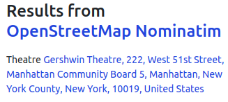
Data consumers that use the administrative boundary hierarchy are any which do geocoding or hierarchical place walks in a general way (i.e. without making specific exceptions for each place). Nominatim demonstrates this:

image

Personally I think it’s stupid that “Manhattan Community Board 5” is part of the geocoding there, but if the people of NYC think it fits the bill, who am I to argue?

In my neck of the woods, many miles away from NYC, we also have local communities and their councils, with a quite similar structure and issues – those are advisory bodies to the local assemblies with limited prerogatives, elected on the “whoever appears to vote” basis, and not very demographically representative. And yes, they have well-defined administrative boundaries: for most large(ish) villages, they correspond with the village boundaries, but a single local community council may encompass several small villages/hamlets. On the other hand, cities have multiple local communities, whose boundaries do not always match the traditional "neighborhood"s or "quarter"s.

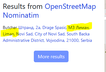
We have them modeled as boundary=administrative at admin_level=10, at least where they do not already match village boundaries (which are at admin_level=9). And yes, I also find it annoying that Nominatim considers them a part of the address:

MZ Liman

So, “МЗ Лиман” is the local community boundary, which we would hardly consider worthy of mentioning in an address context, and “Liman” is a city quarter (place=suburb) which sort of makes sense, but is also not traditionally regarded as a thing in an address.

To finally get to the point: I think similar community districts are common across the world, and have their place in OSM. We should not “map for the geocoder” – Nominatim would be better off implementing country-specific rules rather than crudely applying “one algorithm fits all”.

2 Likes

A community board represents a community district. Community district is use to identify a collection of neighborhoods and at times is a proxy for other government services. BetaNYC has a map that outlines all of the community districts and other political and administrative districts in NYC.

Quite a bit of the City’s data is tagged to a community district and we running mapping events targeting community districts.

I would love to ensure that all NYC Community Districts are in the map at a comprehensive level. Unlike City Council Districts, their lines are set by the City Charter and would require a charter amendment to change.

3 Likes

I like where the conversation is going here. Something curious about the inherent hierarchy of admin_level is that below a level 8, there starts to be a breakdown of what is truly administrative. As @stevea @Minh_Nguyen and @ZeLonewolf have all been discussing, what about these districts makes them, “administrative”?

I read the report the other night about what these are and aren’t. I took a deep dive (:rabbit2::arrow_heading_down::hole:) into the administration of NYC and noticed that the borough president once had a lot of power, and that these boards formed an instrument of their reach. However, since a SCOTUS decision in the 1990s reduced their importance quite a bit. I hypothesize that the weaking of the borough president has affected these districts.

What I feel like we need is a simple binary definition on what is administrative. Is it the ability to pass laws? Elect an executive or body of governors? Some special tax districts can do those things yet are not incorporated municipalities. Those have a better shot at being administrative than these boards.

For complex local government standardizations, I do like to turn to the US Census. They have a report at each state level on what exactly is a municipal government at every level :page_facing_up:. This analysis goes into astounding detail as to the nature of all 3,420 local governments in New York yet it does not cover community boards. Only in a footnote do they mention:

The boroughs in the city of New York are substantially consolidated with the city for governmental purposes, and are not counted as separate governments.
https://www2.census.gov/govs/cog/gc0212ny.pdf p. 1

Instead, the Census groups these into Census Public Use Microdata Area (PUMA) statistical areas.

Based on the discussion so far I am leaning towards keeping these in the map but under another type of boundary, as others have suggested. I do wonder though what falls lower than 8 in the heirarchy. Perhaps special tax districts are clear cut for 10 if they have well established boundaries?

1 Like