Looking for More Sources on Official Boundaries

I discovered this dataset a few years ago. I have used it to check or validate the boundaries between Thailand and Myanmar but never pursued trying to make it legal. I don’t have the patience necessary to deal with either the OSM administrators or Humanitarian Data Exchange, the compilers of the boundary data.

It is a very comprehensive dataset as you’ll see when you look at this page,Humdata Thailand which contains links to only Thailand data.

The shapefiles I tested are described thusly:

tha_adm_rtsd_itos_20210121_SHP.zipSHP (358.4M)
Modified: 27 January 2022
Thailand administrative level 0-3 shapefiles

The download link for those shapefiles can be found on the page linked below. It’s the second dataset from the top of the list:
Thailand - Subnational Administrative Boundaries
Thailand administrative level 0 (country), 1 (province), 2 (district), and 3 (sub-district, tambon) boundaries

This data is apparently owned or administered by an affiliated organization called OCHA. I never contacted that organization but if you’re interested and have some time, I encourage someone to do that. This would be an invaluable dataset for OSM mappers if it could be made legally available.

Best,

Dave

The only official source I could identify that didn’t have a copyright issue was the royal gazette. Thailand has a big problem with overlapping and inconsistent boundaries.

However, there’s been an effort to create a unified boundary map of Thailand called onemap. I haven’t tried it yet but perhaps you might want ro see if it’s useful?
https://onemap.onlb.go.th/login

1 Like

Thanks a bunch, @AlaskaDave! I’ll take a look at the data and see if I can make it reusable.

Thanks, Mishari! The site has a login barrier, and I couldn’t find a signup page. I’ll investigate further to see if there’s a workaround for access.

Hi. Haven’t checked in in a long time (got an email notification when you linked an old post of mine in the service=alley thread the other day). The forum sure looks different.

Anyway, there certainly are official datasets for Thailand’s administrative boundaries and other stuff. They’re available at GISTDA Portal, https://gistdaportal.gistda.or.th/. The admin boundaries are under this tag, and here are forests and protected areas. The problem that’s kept them from being imported is that the government has been really muddy on the use conditions, and even with data that’s explicitly under Thailand’s Open Government License, there still are attached conditions that are likely incompatible with OSM’s terms.

The One Map project I understand is supposed to unify the different agencies’ digital data for law enforcement purposes, so it might not be publicly accessible.

Hey @Paul_012, it’s great to have you back!

Many thanks for providing the official datasets links!

Do you have any pointers on the location of these attached conditions ?

It’s the DGA Open Government License - available at https://data.go.th/pages/dga-open-government-license. It mostly applies to data provided at data.go.th, which includes tabular coordinates data that we looked into several years back. This is actually a newer licence that replaced the previous one in effect back then.

1 Like

Thanks @Paul_012! I included below your last comment on that thread so hopefully we can hopefully continue the conversation here and get more insights from anyone knowledgeable.

You are diving into a rabbit hole here.
Besides the license of the data, you have to deal with disputed areas then looking at boundaries.

I do not know the recent status of border disputes. Are there any still ongoing or are they all settled? There are multiples and even a Wikipedia category exists to list them.

Another point to pay attention to when looking as such large-scale maps is the projection used. I believe all these hand-drawn maps utilize Indian 1975, which on top of the accuracy issue of the drawing adds another half a kilometer of projection error into it if you don’t re-project into WGS84.

National parks are also a difficult topic. I vaguely remember of having heard of rich/influential people wanting to build nice houses in areas which are national parks and the boundary was adjusted for them.

Borders are extremely difficult. They always come with a political touch. I personally tried to stay away from mapping them too much. There are sometimes on-the-ground feature like waterways which can be used.

And even there, we say “the devil is in the details”. Is the boundary in the middle of the river, or on one side? If so, at which water-level?

Sometime we might expect a level of accuracy, which does not exist in real life.

I remember years ago when I was visiting the Three Pagodas Pass in Kanchanaburi. The border to Myanmar was closed. But behind the shops was a hole in the fence and locals travelled there between Myanmar and Thailand. Was so unofficial, that on the other side motorbike taxis waited for people. Consequence had been multiple military check-points in the area to check ID documents of people in the bus, as border was known to be more of a theoretical border.

I believe 10+ years ago I participated in importing some of the initial boundaries. They had been very rough, but at least allowed to see Thailand and the provinces on the map. Going down to Amphoe level was impossible at that time.

The following is from a conversation between myself (AlaskaDave) and julcnx in Changeset: 117469089 today

Hi Julien.

Today I came across this admin_level = 5 boundary you mapped or adjusted a while ago and I have a couple of questions. In the Wiki, it states that there is no admin level 5 in Thailand. This boundary between Mae Taeng and Chiang Dao, both being districts (amphoes), would seem to fit into the admin_level 6 category. In addition, I have zero experience with naming boundaries or assigning boundary tags so I’m unsure about how to name this one, or even if I should.

I’ve been using the Thai Topo map in JOSM to adjust boundaries in my area of Saraphi and it seems to be fairly accurate. You quoted WorldTopoMap as your source here but JOSM doesn’t offer that imagery. Is it still available in the iD editor?

Naturally, the Saraphi boundary I mentioned always defines the boundary of two subdistricts. Saraphi itself of course and the various bordering subdistricts. The name of the one I’ve adjusted is named merely Saraphi in OSM. In reality, it might be best split into segments where it shares a boundary and that segment named accordingly, e.g., Saraphi-Hang Dong

Even though the Wiki definitions are always suspect because so many contributors and editors are clueless or don’t know how to write, or both, it does seem clear that admin_level 5 is not in use in Thailand.

What are your feelings about adding a name and/or changing the admin_level of this boundary?

Dave

Hey Dave,

Thanks for reaching out!

Just to give you some background, I added those partial boundary edges a while back with limited knowledge at the time. They’re handy for detecting paths, like fire breaks, forestry tracks, or walking paths, since they often align with those features.
Regarding the WorldTopoSource, it’s deprecated from ESRI and shouldn’t be relied upon. I noticed it used on some public government sites and assumed it was viable, but that’s not the case.

Ideally, these boundaries should be reworked into districts (admin_level=6) and sub-districts (admin_level=8) relations, similar to what’s been done for provinces (admin_level=4). That way, they’d have meaningful names.

It’s been on my todo list for a bit, but now that I’ve found some open data we can use (GITSDA), it’s given me a bit of a boost. Just need to squeeze in some time for it!
Anyway, I’m glad to see someone else interested in this topic. Feel free to make any changes you think are needed.

By the way, could you let me know where I can find the “Thai Topo” source you use in JOSM?
Comment from AlaskaDave about 2 hours ago

The Thai Topo I mentioned is available as an imagery layer in JOSM. I have been using the OpenTopoMap layer for some time but the Thai Topo layer has details OpenTopoMap doesn’t have, for example, boundaries of districts and National Parks. However, they must be hand-traced from the imagery, just as you would need to do if it was a satellite image. Tedious but better than nothing. It also contains the names of many residential streets, temples, schools, towns, routes, waterways, etc. The route refs, however, are sometimes out-of-date so I presume the data isn’t all that fresh. Aside from that, the names of towns, rivers, and temples etc., don’t usually change over time and the checking I’ve done shows mostly good agreement with current names.

Please give me some tips about the GITSDA data. I went to the site Paul_012 provided earlier and could get only KMZ data for boundaries.

(I asked next if we should move this discussion here as an extension of our conversation about Sources of Official Boundaries. Julien agreed and so I copied a slightly edited-for-clarity version here. He also said he would explain how to use the GITSDA dataset.)
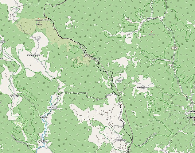
1 Like

I’ll revisit this later, but just to give you a heads up: I attended a talk by a local Law professor at SOTM 2023 in Bangkok. She discussed the usage of the Thailand Open Data license, and from what I gathered, it seemed like we can actually use data licensed under that for OSM. However, I’d like to double-check and get confirmation on this.

Not entirely my focus right now, but what I’m really into is adding districts (Amphoe) and maybe even sub-districts (Tambon). The boundaries don’t have to be spot-on, but having some official data would definitely come in handy for things like finding addresses or planning out potential trails. As you may know, administrative boundaries tend to line up with forestry tracks, fire breaks, or just good old hiking trails.

Thanks for circling back, @AlaskaDave!

Feel free to test out the data on JOSM/ID by incorporating a custom TMS layer using these URLs:

https://gistdaportal.gistda.or.th/data/rest/services/L05_AdminBoundary/L05_Country_GISTDA_50k/MapServer/tile/{z}/{y}/{x} (Country boundaries)

https://gistdaportal.gistda.or.th/data/rest/services/L05_AdminBoundary/L05_Province_GISTDA_50k/MapServer/tile/{z}/{y}/{x} (Provinces boundaries)

https://gistdaportal.gistda.or.th/data/rest/services/L05_AdminBoundary/L05_Amphoe_GISTDA_50k/MapServer/tile/{z}/{y}/{x} (Districts boundaries)

https://gistdaportal.gistda.or.th/data/rest/services/L05_AdminBoundary/L05_Tambon_GISTDA_50k/MapServer/tile/{z}/{y}/{x} (Sub-districts boundaries)

Took a peek today for the first time. Initially, it seems to match up with the official PDF drawings, but alignment might be a bit off again. Also, the country boundaries around Arunothai don’t seem to match up with what’s happening on the ground.

Do you mind sharing your JOSM imagery layer settings? I can’t seem to find any Thai Topo imagery in my list. I’m a bit worried that this ThaiTopo might be the Royal Thai Survey L7017 50K maps, which is licensed and not free for use.

OMG! I hope that isn’t the case. I’m not sure where I got the link from originally but it looks a lot like the ESRI World links:
tms:https://{switch:services,server}.arcgisonline.com/arcgis/rest/services/World_Topo_Map/MapServer/tile/{zoom}/{y}/{x}

Ah, that’s the familiar WorldTopoMap layer from ESRI that I’ve used before :smiley:

https://www.arcgis.com/home/item.html?id=30e5fe3149c34df1ba922e6f5bbf808f

It’s pretty spot-on in terms of accuracy, but the downside is that it hasn’t seen any updates since 2013. DWG got in touch with me and emphasized the need for explicit written permissions from them:

I teamed up with @nitinatsangsit to try reaching out to both ESRI Thailand and their global team to see if we could secure permission to use it for OSM, but unfortunately, we never heard back from them. :frowning:

Thanks for the info — I will discontinue using that as a source unless we can get permission from the Thai authorities. That seems doubtful though.

When I obtained that layer, I must have invented the useful name, “Thai Topo” at the time. That’s why I didn’t recognize your reference to that layer as WorldTopoMap earlier.

I did load the District Boundary lines from your listed sources into JOSM and found them difficult to use without some sort of specialized Paint Style inside JOSM to make them more easily visible. I’ll work on that but in the meantime, I’ll refer to them rather than the Thai Topo when boundary issues pop up.

1 Like

Yeah, it’d be great if there was a simpler way to style the imagery layers right from the source. When you’re working in JOSM with a light imagery background like OSM Carto, it definitely makes visualization a bit easier.

That’s worth a try.

I don’t intend to mess with these boundaries much because it’s a lot of work for very little payback.

Thank you though.

1 Like

Hello,

this mentioned " World Topographic Map" is a proprietary product.
As per the details page, the data for Thailand is owned by Esri Thailand.

I am quite certain we have no permission to use this map to derive any data out of it for OSM. Please do not use this within your editor.

I am not surprised that there was no answer to your request. Such larger companies are not prepared to answer questions from individual seeking for exemption from the standard product license.
You might have better chances if you find a direct Esri contact at some conference or reach in via some sales contact. And even then, there is no guarantee that Esri will support the creation of a competition product by allowing to use data for OSM.

Best way is to convince the government to release the source data in a compatible license. I have not checked GISTDA details.
As always keep an eye on the projections used in your data source and editor. above is EPSG:3857.

Stephan

1 Like

@Paul_012, Are you sure that the GISTDA L05/L10 layers you provided are accessible under the Open Data Thailand license?

I know that some smaller GISTDA datasets have been released under the https://data.go.th/en/dataset?q=GISTDA.

However, I haven’t come across any L05/L10 layers there, and on the GISTDA site, it only mentions “Share Level: Public” and “Credits (Attribution): GISTDA.”

Sorry, I was only drawing a comparison. What I meant was, even with data that’s clearly under the DGA Open Government License, there are still issues due to incompatible restrictions. But the GISTDA layers don’t have clear usage terms listed at all, so the situation with them is even more difficult.

Actually, this was previously mentioned in this thread:

If someone’s interested in an armchair project and has the labour effort to spare, they could load the layers as a guide and manually re-trace the boundaries from the natural features that they appear to follow. This would be much easier than following the textual descriptions in specific legal announcements (i.e. "from this point, the boundary follows the right bank of this stream, until it reaches the confluence with this river… etc.), which I previously tried for some districts. But this is still not quite feasible on a large scale.

1 Like

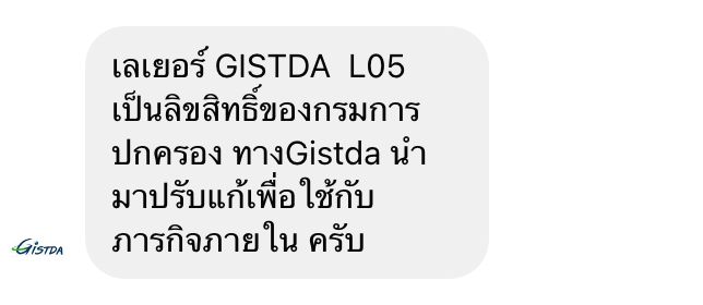
Update: GISDTDA responded on their FB page:
image

Translation: The GISTDA L05 layer is copyrighted by the Department of Provincial Administration. Gistda has modified it for use with internal missions.