Now is the moment for RFC on the proposal .
https://wiki.openstreetmap.org/wiki/Proposal_talk:Extended_traffic_signs_tagging
Thanks for the link – lots of discussion there. By the way, if you intend to hold a formal RfC, you’ll need to create a separate thread in this category and also post to the tagging mailing list (or ask someone else to do it). See the proposal process for more details.
Edit: Oh, you posted one already. ![]()
And you have changed the OSM wiki already to say something different as it said before (it was ironic). I don’t know if this can be done with a proposal working. Thank you for insulting me as pedantic. It is clear it is fair-play. ![]()
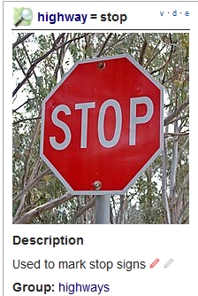
For those following along, the wiki’s description of highway=stop came up in a discussion yesterday:
The tag highway=stop is used to map points at which vehicles are required to stop. This includes stop signs, stop lines and (potentially) other points where a physical stop is required by law.
In the infobox, it also said, “Used to mark stop signs.”
@yopaseopor pointed to these passages as proof that the tag represents the sign itself. However, the rest of the page goes on to detail exactly where a mapper would position the node. In reality, the only reason the page says “stop sign” is that English doesn’t have a convenient word for the-place-at-which-a-vehicle-comes-to-a-stop-in-order-to-obey-the-stop-sign-or-stop-line-if-no-other-vehicle-is-already-stopped-in-front-of-it.
We’ve come full circle back to the original point of contention at the top of this thread:
To prevent further confusion, I edited the highway=stop page to clarify that it doesn’t represent the sign itself. This edit changed the wording but not the substance of the page. After all, the rest of the page remains unchanged, including the diagrams. I do not believe this edit is unfair to your proposal. In fact, it helps this community better understand the status quo that your proposal would affect so that they can make a better informed vote. If the community can’t edit any page that an in-progress proposal links to, then we might as well lock the whole wiki.
Perhaps “pedantic” was too strong a word, but your RfC is a request for comments, so if you continue to insist that highway=stop has been intended for the literal sign all along, then my feedback to you is that you are mistaken.
1 Like
There are 33.5k traffic_sign=stop already. Nothing is changed.
Furtheremore, there are a few dozens of =stop_ahead and =yield_ahead (should be =give_way_ahead ) for your offending case. Although as how there are 184 hazard=traffic_signals over 24 =signal_ahead and a few title case =Ramp_Meter_Ahead , the dozen =hazard + hazard=stop should be considered. Unfortunately again, some countries are using warning signs, others the inverted triangle (can be without text inside to make it different).
There are a few others =maxspeed_ahead (cf similar few hazard=maxspeed , =school_bus_stop_ahead , =dual_carriageway_ahead , etc. It does show a need to clarify advance “warning” signs.
Well, I don’t think that so to prevent other changes as members of Spanish community recommend me I will change the links of the proposal to point to the specific wiki version it is based on. People from Spanish community says words as “guarrada” o “que cambia bastante el significado” (you have changed the summary , the first two lines people it is more probable to read rather than all the page).
I don’t know your quality of Portuguese, French or Spanish, but to get clarified you should change also all the translations of the page you have modified because now they are not saying the same as original. One important thing: “Señal”, “Sinal” or “Panneau” are translations of “Sign”, traffic sign (marks are a kind of traffic_sign and in come countries they have its own national code (traffic_sign:id=* ) . But remember this proposal is NOT about highway=stop or highway=give_way. It is about position of traffic signs, side, direction and using traffic_sign=* to categories with human readable values and traffic_sign:id=* to national id types of traffic signs. So your changes in the wiki don’t not affect this specific proposal.
There are 1.6 million highway=stop.
In my opinion we will use whatever it has in the national traffic law. For the same meaning we can have warning, prohibitory, mandatory or advisory signs. But we map the sign, also with the specific pic (traffic_sign:id=*) so it is not about “interpret” the meaning of the traffic sign rather than map whatever you find , with the form you find. For some countries stop ahead is give_way with the distance. We don’t have to invent anything. Warning is warning (hazard) , give_way is give_way, distance is distance.
Remember this proposal is not about the specific categories or human readable values. This will be a way starting to make more specific proposals if this proposal is accepted.
If so, how is it that my edits were unfair to your proposal? It’s just part of routine maintenance to make the pages more presentable. I just finally got around to fixing the inconsistency because it came up as a point of confusion during your proposal’s RfC. I’m glad that you don’t consider a redefinition of highway=stop and highway=give_way to be within the proposal’s scope.
My Spanish is good enough to make Spanish speakers beg me to use English. ![]() Yo sé que en español también se dice “señal de parada” (o rótulo de Pare en Puerto Rico). Sin embargo, hace cinco años que la traducción en español usa la misma definición que he entrado en inglés el otro día:
Yo sé que en español también se dice “señal de parada” (o rótulo de Pare en Puerto Rico). Sin embargo, hace cinco años que la traducción en español usa la misma definición que he entrado en inglés el otro día:
La etiqueta highway=stop se utiliza para mapear los puntos en los que los vehículos deben detenerse.
1.6mn highway=stop are added at the intersecting point, or at the stop position. Is there even 16 excluding yours that are adding it at a stop ahead or stop sign at different positions?
Probably some Mapillary’s recognized in some countries are of that kind. Think about it, it is a very common situation. If we can’t find more values as you are talking about in taginfo is because people does not use that formula. I don’t know numbers but with one million items probably there are hundreds or thousands now you can’t distinguish …
No. I’m not judging your good intentions to clarify the wiki but where you think there is a consensus in that question probably there is not. Wiki is very clear: “Utilizada para indicar una señal de detención” (Used to mark stop signs) in description, in the index. Forget about “this is because we don’t have better words to express that can be at the point of detention, the mark , the traffic sign or the intersection itself”. Sign is sign. Señal de detención (no “punto donde debiera detenerse el vehículo”). Probably it was done with good intentions to interpret the lack of vocabulary for people that makes the law. But if you only read on the diff wiki you read |description=Used to mark stop signs vs. |description=A point at which a vehicle must come to a complete stop, without any misinterpretation. And sorry , but for me there are not the same. It does not affect the proposal because as we can see it is a point of controversy, there are so items and it is difficult to clarify if there are mapped in one or other way. Futures proposal can talk about all kind of stops we have in the World, and the possibility to review it to specify if it is the traffic sign, the mark, the intersection or whatever. But not this.
To me, this is cherry-picking the literal wording of one small portion of one language version of the page – an important portion, no doubt – to justify your description of the tag as nothing more than a sign. I don’t understand why we need to take this wording so literally or fuss over it as if it’s set in stone. It seems like both of us more or less agree on the purpose of the tag, but we disagree on how to define it. This leads to the awkward situation that you’ve tagged highway=give_way where the driver sees a yield sign but should not yield yet. But at least we don’t use actual stop and yield signs like that in the U.S.…
1 Like
In Spain in major cases, traffic sign, traffic mark and point where you have to give_way is the same node to map.
Perhaps I misunderstood the original controversy. This node has distance=150 m.[1] Does this mean the driver must yield on the spot, or in another 150 meters?
This value is technically invalid; there should be no period after the
munit symbol. ↩︎
I have said major cases. But what is the problem? If you put distance=* you will know the traffic sign would have effect in 150m. (where probably you will find another traffic sign like this without distance). traffic_sign=complementary signs are for this so this you have would be:
highway=give_way / traffic_sign=give_way
traffic_sign:id=ES:R1
traffic_sign:2=complementary
complementary=distance
distance=150 m.
traffic_sign:2:id=ES:S800
Your proposal says that highway=stop and highway=give_way are being left alone. If so, then the status quo is that most of these nodes will not be combined with traffic_sign tags, because the stopping/yielding location is almost always mapped separately from the location of an “ahead” sign. This is important, because every data consumer that understands highway=stop and highway=give_way interprets them as applying on the spot, not at some arbitrary distance ahead based on distance=*. Currently, this tagging combination is practically unique to your contributions, so data consumers are unlikely to consider it. You’d be well-advised to conform your tagging in Catalonia to that of the rest of the world, even if your proposal passes.
A difference of 150 meters (about 10 seconds traveling at 55 km/h) may not sound like much, but when OSM data is already being used in real, consumer-facing driver assistance products on the road, we cannot afford to be cavalier about concepts as basic as stopping and yielding. There has been plenty of discussion so far but still no clear and convincing rationale as to why we should wave our hands about this distinction.
I have only been half-following this thread, but if I am right to assume that a current point of contention is whether or not highway=stop and highway=give_way have consistently been used only as vertices on roads (i.e. at the stop position) rather than as free-floating nodes at the position of the traffic sign or not, some numbers would help.
I.e. analyze how much percent of highway=stop etc. have been mapped as vertices of ways and document it accordingly.
Unfortunately, I don’t know how to efficiently analyze that. Is it possible (easily) with Overpass? - I don’t know.
No, the author still adds the advance warning signs as points on the highway= road. This means it is impossible to detect. Differentiation with stopping position is impractical from the variation in intersection size, and merge geometry.
What you thought is still impractically slow to infeasible in Overpass (I don’t know SPARQL). Or, at least I don’t want to hog up many unknown minutes of running it on the server. Best done offline.
node[highway=give_way]->.control;
way(bn.control)[highway];
node.control(w);
out count;
Performance-wise, this could run in reasonable time in a SPARQL engine, but unfortunately neither Sophox nor QLever exposes information about which nodes are part of which ways. Sometimes you can get lucky by finding a node that intersects the way, but floating-point errors dramatically limit the results.
With an Overpass-turbo query (overpass turbo) you can find all the give_ways with distance (39 of 1 million). But remember for this proposal of traffic signs I will not count with any highway=stop or highway=give_way as a big element of controversy. I think probably it will have its own proposal about that and the discussion will be tough.
1 Like