I understand that almost all of the time it is not really a ford.
But isn’t the context (desert, intermittent stream) clear enough to require something else than “ford”?
Many of these features were imported from data sources that distinguish them from ordinary waterways as either arroyos (GNIS) or washes (NHD). This table shows that NHD feature codes 46003 (intermittent stream), 46007 (ephemeral stream), and 48400 (wash) were all conflated with each other as intermittent=yes, which seems potentially problematic. If we do intend to retag these features based on a more nuanced understanding of the different feature types, then we should probably do it before nhd:fcode=* and its variations get wiped away as unnecessary import cruft.
That seems to be where this discussion is heading. As I understand it, ford=* exists because a) it used to be more difficult for renderers to label an intersection between ways without a special tag on the node; and b) some of these crossings are places where you can ford, while others are places where you cannot ford, regardless of the weather. By contrast, whether you can cross a wash or not largely depends on the weather, not the specific location.
I checked a few in my area, and they are tagged as nhd:fcode 46007 (ephemeral stream). IMO We need to tag these as ephemeral or gully or something else, they are very different than an intermittent stream.
Here’s sort of an extreme but relatively common case for imaginary fords: Way: Bow Willow Creek Road (910295805) | OpenStreetMap
The only time I know of where there was any appreciable surface water in Bow Willow Creek was when the remnants of Hurricane Kay blew through in 2022. That carved a new channel in the wash. It would have been entirely impassable while the water was flowing, and it remained impassable by wheeled vehicles until it had dried out and the new, steep banks had been broken down (which took a few days).
Also, the mapped location of Way: Bow Willow Creek (5951063) | OpenStreetMap is something of a fiction. The waterway is generally around there somewhere, but Kay cut a new course that differed from the previous course, and I expect the next flood will do the same.
To add to it, the location of the highway is imprecise as well. It’s also generally around there somewhere, but it’s braided and the braids gain and lose favor as the surface conditions and vegetation change.
So, the places where the waterway and highway intersect in OSM are not really where the road and watercourse intersect on the ground. And the number and position of those intersections changes over time.
Aside from finding better tagging for fords-that-aren’t-fords-for-the-vast-majority-of-times, @imagico has a very nice proposition on better rendering for regular fords: Water under the bridge | Imagico.de
Alas, he warns that “Rendering node based fords similar to bridges requires quite a bit of effort and i am afraid this significantly adds to the already complex road code.”
Here are some even better examples of imaginary fords where someone has actually gone through the trouble of adding ford=yes to all the mapped highway/waterway intersections:
Of course, my comments about the shifting locations of both the waterway and highway apply here as well.
And here’s an Overpass query if you’d like to find some other possible examples: overpass turbo
After reading this thread and related pages, I’m thinking that “ephemeral=yes” might succeed in a second try if the proposal was cleaned up after some more talk here.
Maybe a quick poll could help to find out what options people are preferring?
There are two issues that I see discussed:
- How should a mostly dry waterway be tagged?
- How should the crossing of a path/highway with such a waterway be tagged?
Looking at the changeset comments, all they did was clicking the preferred solution suggested by their editor. I would not call that going through trouble.
Perhaps the wording changed, I mentioned above, for my taste, there are too many CS comments closed:osmose:1070 that I observe. @Minh_Nguyen – would it be possible for the editor to suggest in addition to adding a ford/bridge/whatever – There is no stream there?
PS: This is the US chat, but I am feeling very much at home, here people map fords where there are culverts, sometimes they even map bridges on roads in the wrong locations, map culverts where there are bridges and map bridges where there are culverts, and so on, because all of that bad imported governmental data and bad aerials that are of no help to determine actual ground truth. Wishing a bit of survey on location from the community!
This changeset comment indicates that the mapper was responding to an Osmose issue with the “Osmose issues” layer enabled. When you view an Osmose issue, you only have two options: close the issue after fixing it manually, or remove the issue because there’s nothing to fix.
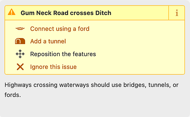
iD’s built-in validator would also warn about the crossing:
As you note, there’s no option to say that the waterway isn’t really a waterway, or that the road isn’t really a road. This would be a valid feature request – something like a “Retag the crossing feature” option that, when clicked, brings you back to the feature type menu. It would save the mapper a few clicks. However, it could also be risky to suggest to armchair mappers that they can silence warnings and improve their “score” in HDYC by changing the waterway into something else – a park or beach perhaps? ![]() Ultimately, the mapper needs to be circumspect and responsible when resolving a validator warning.
Ultimately, the mapper needs to be circumspect and responsible when resolving a validator warning.
Even without adding a button, one could easily (I assume) add more text to the “Highways crossing waterways should use bridges, tunnels, or fords” saying something about how if one of the features is wrong then it should be removed or retagged. But then you might run into issues with actually-intermittent streams when someone is only looking at imagery instead of being familiar with the area, where someone removes the feature entirely when it really does belong.
Isn’t this just Tagging for the Validator?
I don’t think so. Based on our definitions, a waterway can cross a highway on a different level (bridge, tunnel) or is sharing nodes, which should be tagged as ford.
So if that is not the case, the validator is “right”. The “issue” are we mappers blindly resolving this “issue” by adding one of the above without considering it actually is a waterway, since intermittent=yes can’t be detected remotely. In real life intermittent is also pretty wide ranged for a simple boolean. Especially in areas like the US, where all those “waterways” got imported. In areas where waterways are just mapped by mappers, nobody™ would add the here discussed waterways.
Overall it makes sense to me adding that hint to the validator as well as adding more information to the waterway and ford.
I do not agree with this statement. An intermittent (as tagged in OSM) stream crossing a trail or road is very likely to not have a ford.
We may be mostly in agreement because it sounds like you would like to define these ‘almost always’ dry gulchs as something other than a waterway, I’m in agreement.
Would an ephemeral waterway need a ford??
Waterways include linear water features such as rivers, canals and streams, as well as water areas such as lakes, reservoirs and docks.
The problem was introduced with intermittent=yes being not specific about the frequency it actually is a waterway. It can be completely random, it can be after a rainstorm, it can be … If I need to consider as a user of the highway anything if there is water, I would expect a ford=yes. If the result is more like a puddle, rather not.
I like this play on words. Sadly, it does not translate into my mother tongue, there is no verb to ford, only the noun. Here, a place where it is convenient to cross a river is called a ford. Understood like this, crossing=ford becomes a sibling of crossing=bridge – the only difference, wet feet vs. dry feet.
Small streamlets (can jump over) or dry gullies/washes (no water there) do not have fords (the noun). But they still can become ford=no (the verb) at times (better use hazard there?)
I understand, that OSM terms need not have the meaning of colloquial terms. I guess the topology enthusiasts know that too. This reminds me of tagging every intersection of a pedestrian with a motorised highway a crossing. Perhaps one day we will tag any intersection of motorised highways a junction for the sake of topological correctness (mind you, there are T-junctions too.) (Not that I want to advocate the absurd.)
Maybe ford=no is better understood as not:ford=yes – that is, not only is there nothing that I can call a ford here, but I also want to let you know that you must not use this location as a ford, because otherwise you might guess that there is one, based on the intersection of two ways.
The same reasoning applies to crossing=no (aka not:crossing=yes): you must not use this side of the intersection as a pedestrian crossing. But over yonder, you may cross the driveway even if I don’t explicitly call it a crossing.
This weekend, I had the pleasure of driving City Creek Road where it crosses Bear Creek, one of the main tributaries of the Santa Ana River.
The segment of City Creek Road linked to above has been mapped incorrectly, and it happens to be a great illustration of what’s wrong with the ford tag.
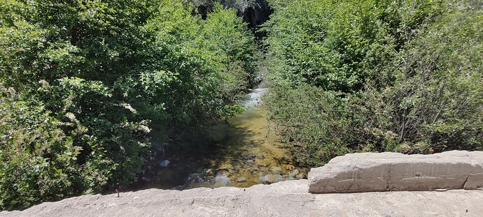
There’s actually a bridge where City Creek Road crosses Bear Creek. This is not currently mapped in OSM (although it should be). Here’s a picture from the bridge, looking upstream at Bear Creek.
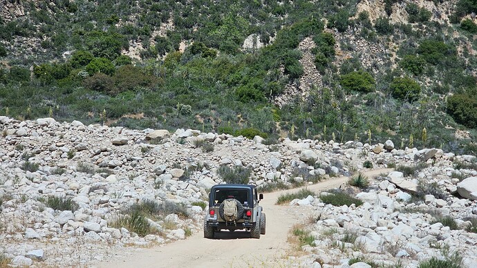
That entire segment of City Creek Road is tagged as ford=yes, but here’s what it looks like with my Jeep for scale. If there was actually enough water for Bear Creek to overflow its banks and inundate this boulder-strewn channel, there would be no way to cross such a torrent.
You can easily see these things in the aerial imagery for this location.
How did we end up with mapping like this that does not reflect the real-world conditions on the ground? It’s the insistence on three things:
- Every place that water has ever flowed (no matter how infrequently) is a
waterway. - Every time a
highwaycrosses awaterwaythey must intersect and the intersection must be tagged. - And where the waterway and highway are on the same
level, that tag must beford=yes.
But what’s really going on here is that my Jeep is not in a waterway (at least not as conventionally understood in OSM) and there is no ford.
Your Jeep-picture is a good example. If there is really water flowing in a way the rocks indicating you wont be able to use that road. Maybe a Unimog or Alcea truck would still be able to pass it. If this is happening regularly, that information should be in our data and a simple boolean-ford is not enough to describe it.
Similar like a mountain pass is closed in winter season. A ordinary road in Alabama would be impassable when covered with snow, though that’s something we won’t add to our data.
That’s common practice, though I don’t think it’s a useful definition. If I water my lawn and the water is flowing to the drainage, the sidewalk is not a waterway even though it’s happening every morning. ![]()
Also the other way around, if there is no water flown since years, it’s maybe an abondoned:waterway ![]() or however you call it.
or however you call it.
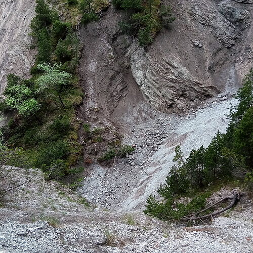
Well, today stumbled over another armchair ford, right in the middle of picture:
There actually is water there most of the year, I did not see it, but I heard it. Though here it flows under the scree. Another kind of intermittent stream – intermittent not in time domain but in space domain – visible only occasionally but mostly hidden (level -1?).
Additionally, I do not see a path there, in the location of the ford. The destruction tells me though, when there is visible water there, it is likely wise to not ford!
On the ground the path leading up to the streambed can be followed, It is also of the intermediate kind, some destroyed sections. The location of the “ford” is off 20m if connecting the remnants of paths on either end with a straight line. The mapper of the ford certainly never was on location, likely mapping close by enough for the validator to engage.
I put that on the stream. No idea what else. I yanked the ford, and the path. I do not see how the newly drafted wadi can help here.
My problem with comparing mostly dry ground features to streams is misguoded. A surface wash or eroded ditch have nothing to do with waterways. They were created by unique water events such as rain or flooding. Each might be dangerous in due to the amount of water it catching but become harmless soon after the water event ends. The important part is that both features never get the water from another waterway. It is always from surface water.
