Just an extra note, for those accusing me of ‘tagging for the renderer’, over the last few years I have already retagged many Track labels to Unclassified - even if the ways were often unpaved and quite rough going - because they were ‘used for local traffic and used to connect other towns, villages or hamlets’. But, there are still some ways connecting settlements that are just too narrow and/or rough to call a road.
See all the Unclassified in white? Guess what a lot of them used to be tagged as… And look at how I’ve done it and how the way network typically turns down in quality. TBH, I might have to reclassify some as they often just aren’t passable in sections for average drivers unless in an offroad capable vehicle. Certainly in rainy season (at times impassable even in an offroad vehicle) . I have met normal road cars and road bikes stuck or having to turn round on these ways before. At best they can only crawl along very slowly and are at high risk of having an accident/damage/injury.
One thing that would help in these situations is adding a source tag or a note saying that you, the mapper, had surveyed the highway first-hand. When I see the standard source=Bing or source=Mapbox attached to a highway=track I assume the way was mapped by an armchair mapper and therefore the tag might be questionable. It’s possibly a catchall or even an outright guess.
I’ve come across many a highway that was tagged as a track but in reality is a paved road, often only one lane wide, but still a perfectly usable highway. Those cases, I think, are the ones that bring focus to this issue and are the ones most needing a resolution.
It would certainly be nice if renderers, including GPS units, were capable of showing subtle differences between tracktypes and surfaces. I feel much of the present discussion would become irrelevant if that were the case.
I Source as ‘GPS’ when I’ve been there. (So does Russ.)
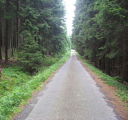
It’s also about narrowness - that is a part of what makes a track a track (and a path a Path, etc.)… In fact, if what you came across was only 1 lane wide then it should possibly still be classed a track. (Eg. look at pic at top of thread.)
I would actually call that a lane - but there’s no Highway tag for that so Track suits best, I guess. This I might call a road:
It can all get subjective as one ‘surveyors’ opinion can be different to anothers… However, the ways I am saying need to be tagged as Track are not paved - they are narrow ways in bad condition.
Although how ways are rendered does make all the difference to the user, a way should still be tagged for what it is. If it’s a track then it’s a Track. If the rendering doesn’t displaying that correctly then it’s a poor visual map, possibly dangerous - where some data should not be included for safety reasons.
There are always going to be limits on what can be shown visually - and this is a reason why the simple difference between a track and road is important - without added tag requirement complications that likely are impossible to show (or survey comprehensively). Yes, great if these extra tags can be correctly added but, realistically, I think paved and unpaved along with correct way type is about as good as you’ll get (in Thai countryside) that can be shown with sufficient difference on a map and that routing scripts might incorporate.
Note, adding anything other than major ways that can be seen well enough from sat pics should not be considered accurate unless physically surveyed - at least in terms of surface, width, condition, etc. Better to underestimate these factors rather then overestimate if armchair mapping - for safety reasons at least.
Will get more pics of tracks leading to hamlet/villages in a week or so - when the weather has improved!
I understand the point about unpaved routes as well. If I’m on the road with my Vios and the navigation suggests a highway=unclassified because it thinks the shortcut would save five minutes and I end up on an unpaved road I’d be quite upset.
Actually it happened to me before east of Chiang Mai in the mountains. But here common sense comes into play. I was told from the beginning: “You drive a city car, you can’t go to the mountains with it.”
So people have a good feeling about what the road standard of a specific area is.
Still the road classification should be made by the function and not by road condition. Surface, width, … all those features have better ways to tag. Thanks to all of you adding surface tags already. Especially for such special roads as in our example here.
But it leads back to my main point. The function of the road is to access the village. And I’m rally talking about places with more than a single house. This road is their main access. The example of Chris is great: http://thaimap.osm-tools.org/?zoom=15&lat=20.0406&lon=99.6518&layers=B000T
That village is served by this main road, which is undisputable in a quite bad condition especially in the rainy season.
But let’s not compare standards of a 1st world country with that one. Even when some forest/agriculture roads are in a much better condition than this one. That paved road in Germany (?) is still a track because the function is to serve for forestry. We could have discussed about “service”, but clearly no “unclassified”. This is not justified by its function.
If we could agree that main roads are highway=unclassified, what additional tags could be used to tell the user: “Hey, be careful, this is not a paved road and the condition is quite bad.”?
I can think of the lanes=* tag or even width=* to tell that the road is narrow. With surface=* we can tell that the surface might be bad. Or smoothness=.
maxweight= if a road can’t support heavy vehicles. or even motor_car=no if not possible at all.
Those tags are already evaluated by some renderers or routing engines.
And you live in CM and were already told not to take your city car into the mountains - yet it still happened to you. People travelling from out side of the area, without local knowledge, who are typically the people to be using GPS nav apps, may well not have a feeling about the road standard in that area. Yes, common sense goes a long way - but you can’t rely on people having it. (And people often follow GPS routing blindly.)
Like I say, I have come across road cars and bikes on these ways before (even ones I tag as Unclassified) and they were having problems. It happens. Good routing apps and maps should help avoid this but they can’t do that if the data they work from is incorrect.
No, it’s not a ‘main’ road. It’s a track. I know what the word ‘track’ means and what one looks like. A main road implies that it is developed. If people are expecting a main road, they are not going to be expecting something impassable unless in an offroad vehicle. These are certainly not main roads. A ‘main road’ actually refers to something more than an Unclassified, minor road, with other roads coming off it.
You want all those tags using? Are you hiring a professional survey team? Any idea how much time and effort it would take to survey and record all that detail? No way that can be done by armchair mappers… Using the terms path, track and minor road correctly (so to tag them correctly as Path, Track, Unclassified) can define a lot of what those other tags define far more simply, understandably and realistically.
As I said regarding the example given by Bernhard of villages in Indonesia only accessible by path - would you call that a main road or a minor road or any kind of road? If not, why?
You seem to care very little for OSM users safety… There are various forum members disagreeing with you in this thread, either directly or indirectly - yet you do not want to listen. I can not see where anyone has agreed with you - but you just keep trying to push this through like they do.
@Bernhard,
That is a most excellent and thorough set of guidelines. I was lurking on the tagging forum when some of those decisions were in the offing so I know it wasn’t an easy process. But our agreement on how to tag these local highways is essential as we go forward.
I think we would do well to check these out and slowly try to come to some sort of agreement about Thailand’s roads and tracks. Plainly there is much to discuss and much to resolve.
Yes, some good reading there and they have obviously gone over this sort of thing before - even if an answer wasn’t 100% clear… So thought I’d ask the Oz contingent straight: http://forum.openstreetmap.org/viewtopic.php?id=53444
Richard’s entry deals with U.S. Forest Service roads but the uses of tags for tracks and unclassified highways bears on our present discussion.
I’m going through and adjusting my Alaska tagging accordingly. I see in hindsight that I have used highway=track tagging somewhat indiscriminately, taking my que mostly from the U.S.G.S. scheme that I was so familiar with in the days before OSM.
highway=unclassified - paved road
highway=unclassified, surface=unpaved/gravel/dirt - unpaved road suitable for cars
highway=service - road to isolated dwelling or other building
highway=track - unpaved track or road suitable for 4x4s
highway=path - narrow linear clearing, too narrow for motor vehicles
Yep, sounds about right.
You have labelled too many as Track? If anything, I have labelled too many as Unclassified…
Only thing I don’t partly agree with, is the reliance on the 4wd_only tag… This is misrepresentative for sort of 2 reasons… 1. Just because a car is 4wd doesn’t mean it’s meant for offroad - plenty of sports and family cars with 4wd for instance - and even a 4wd offroad vehicle with the wrong tyres and ability of driver won’t necessarily be able to tackle rough tracks. Sometimes having a 4wd can make drivers overconfident. 2. A 2wd offroad vehicle is often capable of covering difficult terrain - if the driver knows what they’re doing. Sure, 4wd can make the difference sometimes, but other factors such as tyre and driver ability can matter more. Depending on the surface and terrain, 4wd can have a greater/lesser benefit. Sometimes you really just need clearance.
I would be happier if 4wd_only was renamed to offroad vehicle only - but it’s not a big thing… I think smoothness is the most telling tag. (Though note the Oz group are using extra levels of Tracktype grade - past the accepted 5 - to include the same kind of detail.) I will try to include the smoothness tag more - but this is a tag only field mappers can add… I think users seeing Track should consider that as meaning an offroad vehicle is required - at least in Thailand. Arm chair mappers can possibly add those with some safety - and then tags can be updated as and when actually surveyed. (Note, sometimes on minor roads and occasionally on tracks and even paths, steep sections are paved somehow - but then return to dirt where it’s flatter.) I would strongly suggest any armchair mapper presumes a way not clearly identifiable as a proper surfaced road, tags for unpaved track if wanting to try map isolated country areas - for safety reasons.
quite the contrary. That is why I am so much insisting on a complete and correct tagging.
My definition of “tagging for the renderer” is if you modify the OSM dataset in a specific way because you are not satisfied with the rendering (or routing) result.
So I would tag our example road in a way to say highway=unclassified as it is this villages connection to the main road. And as said before it is a proper village which has even a petrol shop. So the fuel barrels are also brought in somehow.
I would tag surface=unpaved or maybe with another more specific type of unsurfaced.
I would tag lanes=1 if sections are there where you can’t comfortably pass other cars and have to slow down or move to the shoulder. Maybe an maxweight=5t if bridges or other structures involved not allowing higher load.
Then it is up to the data consumer to make an informed decision. OSMand would respect it if I say “avoid unpaved”, so not using this road for routing. A map painter can paint that road in a different style to indicate it needs special vehicles. and so on.
If that road would be tagged as highway=track just to “protect” users from renderers not caring about this then I call it tagging for the renderer.
There are likely safe defaults. A trunk might require to be paved and so on. In another thread we had set up some guidelines on the minimum requirements to a road to justify an upgrade in class of classifieds.
So this thread is intended to define a tagging for the roads connecting villages but not being classified roads.
I still believe that based on the function of the road the minimum category for villages has to be a highway=unclassified. Maybe even for hamlets, but here we enter some grey area, given those remote hilltribe villages with only a hand full of houses. @Dave: Are you still being in Akha Ama for a coffee from time to time? You could ask Lee about his thought whether
roads to such villages should be the lowest category on the grid or fall off the grid.
The Australian tagging suggests to use highway=tertiary to use for such roads. I think this is too high. Also give the fact that we actually have a classification by DRR which apply already to roads which can be so small that you might want to prefer others.
It is also interesting to see that Australian tagging guidelines also emphasise on the use of other tags to describe the physical condition of the road: surface, lanes, tracktype.
Whether smoothness or tracktype to use is difficult. They address similar issues. The name “smoothness” sounds a bit better to me. But might be personal tast.
Re. Correct tagging, the Oz OSM aren’t agreeing with you, Richard in the link AlaskaDave gave isn’t agreeing with you, other Thai OSMers aren’t agreeing with you… Only you are agreeing with you. Sorry but, where was your ‘contrary’ argument? How are you considering OSM users safety?
Who/how has that been done? If you’re accusing me of doing something then please say exactly what. Mislabeling paved as unpaved?
I accuse you of not being satisfied with a way being labelled a track as that interferes with how you would like OSM to route. You want to draw in ways above track standard to villages without considering actual surveyor opinion so you can say ‘all villages are routable’. I would guess that has something to do with the map service you are working on.
Been there? Nope, it’s just a small shop selling in bottles - not drawing out of drums. But even if they were, anything going in and out of that village is either by motorbike or high clearance pickup - via a track.
Have you surveyed this?
Unpaved doesn’t mean it is not unsuitable for normal vehicles. It should be tagged a track because it is a track. You don’t care about how the way renders - you care about how it routes. You are tagging for the router.
OK, that’s your opinion - but unless this is a dictatorship, most opinion and evidence is against yours.
You won’t find many foreigners who go out in this type of country more often then me - if you are trying to find others more ‘qualified’ to argue your opinion. I have worked for water service surveying crews on mapping projects - both out in the field with qualified Field Surveyors and in the office with front-end GIS work. (I have an MSc in Computer Graphic Applications.) However, I am not a qualified surveyor - though I don’t think you would want to listen even if I was.
You talk like you have some understanding of the difference in track quality going in and out of these small villages and hamlets. Have you been out into isolated country in Thailand much? Do you honestly think you can judge this with your level of experience?
Read again - this is no through route. I asked directly regarding this issue on the Oz forum - you can read the response I got.
You are still pushing and pushing - ignoring all evidence and opinion against you. I can only think you must have something to gain personally by trying to get your way here. For me, user safety is key - but also respect for correct recording after actual surveying/mapping is important.
If there is some weird control thing going on here (is Stephan the boss?) then Thailand OSM is not the place for ways that can be dangerous if poorly referenced.
I fear this conversation is getting too heated. Let’s all calm down and take a step back please. We’re trying to work together to solve a contentious issue. There’s no need to be accusatory or defensive. We all want the same thing, which is, to decide how to tag tracks and smaller ways in Thailand.
Let’s try to state what the problem is and then come at it from a different angle.
Can a way into a small, isolated settlement be tagged as Track if it’s narrow, rough, rutted and steep, requires an offroad vehicle (and has been surveyed as fitting the description of a track), or is that not possible?
I would tend to tag such a way as a track. However, if the way connects two hamlets of significant size, I might be tempted to tag it unclassified and in so doing follow the Wiki guidelines as I interpret them. It’s a tough call though and I’m conflicted about it.
Even the Aussies, for all the care they took in writing their guidelines, have difficulty with this topic. For example, they allow one to tag what we would describe as a track (i.e. unsealed, rutted, remote) as secondary or even primary roads, that is, their function is considered more important than a somewhat subjective opinion about their usability. Judging how passable or usable a highway is makes deciding how to tag them a slippery slope. A similar issue is smoothness. We go round and round about smoothness because one person’s “impassable” is another person’s off-road motorcycling fun.
Getting back to the Aussies: They are depending on other tags to more fully characterize the way, some of which either have not been developed or accepted by the general OSM community (tracktypes up to grade8) and certainly aren’t incorporated into most routing algorithms. At least not yet.
But by sticking to the guidelines at least there will be some structure, and hopefully harmony, until such time that renderers can properly display such highways and routers can understand them.
As I always say, Your Mileage May Vary. And I remain conflicted about my answer to your question.
I think what the Aussie’s mean when they state it’s allowable to tag a bad condition way as a primary or secondary road is because they do have some multi-lane dirt ways in the outback that are just too big to describe as a track. A track being relatively narrow. That is why, I have labelled some ways to villages as Unclassified, even though they are in a bad condition and sections of them really only passable by offroad vehicle, because they are wider and more a road then a track. (This is difficult to decide on a times but I do my best - with a consideration of OSM user safety.)
I don’t think Smoothness descriptions are really that subjective, reading the Wiki. I do think though that Smoothness is better to use than Tracktype - especially with the standard 5 levels as they really don’t cover enough terrain type. The problem is, it can only be ascertained through surveying. However, I think the right way type along with Surface paved/unpaved is a good enough indicator and realistically achievable (and about all any routing app might consider and all that can be detailed visually on a map) to try and use for actual map coverage. Smoothness being a bonus…
Bad news: contrary to the wiki on the 4wd_only tag, a " (4WD only)" added to the name cannot be found on the map.
Hence I guess that it is ignored by routers also.
My impression is that the Aussies mixed up (or: “combined”) the tracktype and smoothness tags when they created their 8 different grades (and their grade1 corresponds to “our” grade2). tracktype measures the firmness of the surface, while smoothness describes surface regularity/flatness. By the way, only 202 ways have grade6, 77 grade7, none has grade8.
Though tagging the only access roads to some villages as tracks (when they cannot be used by normal cars) does not feel correct, I’d still prefer them being tagged as tracks than as unclassified/service etc. because otherwise some people might get into danger by using such roads.
Some may call that “tagging for the renderer”, but I prefer safety.
Thank you Bernhard for your honest way of agreeing that tagging them as a track is more a workaround the renderer.
Is this workaround still needed? What kind of major consumers are actually affected? Android navigation is mostly OSMAnd which supports avoiding unpaved. Do you know details about Garmin devices?
For web maps there is the Carto-Style of OSM.org. For this is an open issue logged.
Isn’t it that in principle we agree that roads being the sole way to decent sized villages should be part of the grid and being at least unclassified?
This was also the first sentence of the answer in the Australian Forum:
We’re stuck with the few corner-cases where that given road is in a quite bad condition.
My position was to tag the physical characteristics of the road and leave the decision on how to handle it to the renderer/router.
The other opinion seems to be that the current support of the renderer to avoid or warn of such bad roads is not advanced enough to have such a tagging.
How about agreeing on that the road should be tagged at least as an unclassified unless there are serious concerns about the safety of drivers due to the condition.
In this situation we would still add all the physical characteristic tagging but downgrade the road (for the renderer). We would also leave a note/fixme explaining that is was temporary and should be revisited in a few months (or a year) when hopefully renderer support improved…
‘If it’s a road, connecting a village to some other tertiary or higher classified roads, I would use unclassified.
If it’s a bad road, just to have any connection to and from a village I would use highway=service.
If it’s even not passable for foreigners (like you described) without having problems, I would use the highway=track and an appropriate track type.’
Again, I go back to the example given of villages where access is only by path - would you tag that as a minor road? After looking at it, I will tag a track as a Track because it looks like a track… The way has the physical attributes of a track and not a minor road. That is not tagging for the renderer. That’s honest tagging after actual surveying.
‘How about agreeing on that the road should be tagged at least as an unclassified unless there are serious concerns about the safety of drivers due to the condition.In this situation we would still add all the physical characteristic tagging but downgrade the road (for the renderer). We would also leave a note/fixme explaining that is was temporary and should be revisited in a few months (or a year) when hopefully renderer support improved…’
What exactly are you saying you will do? Leave it tagged as Track? Re. ‘serious concerns’ does this = offroad vehicle required?
@Stephan: Garmin devices can be set to avoid “unpaved” ways and, as we discussed earlier, mkgmap styles can be customized to apply the “unpaved” attribute to any sort of highway the user desires thereby “tricking” the unit into following his wishes. There is no way that I know of to make more fine-grained decisions on the GPS unit other than that one.