There is a big leap between informal and illegal, though
not necessarily, an informal feature could be legal, but often these are illegal. Informal settlements, to give a well known example, are usually illegal.
There is a big leap between informal and illegal, though
not necessarily, an informal feature could be legal, but often these are illegal. Informal settlements, to give a well known example, are usually illegal.
sidewalk=no- there is no actual sidewalk that pedestrians may use. It solves the main issue of routing (why we tagsidewalk=*at all) and It should also help with iD editor and others that hide less popular tags from mappers not to make catastrophic changes.
IMHO this is troll tagging, there is a sidewalk and this is what the tag is about: „ Indicates the presence or absence of a sidewalk (pavement/footway).“
Theoretically, you could also do something like this:
highway=residential
sidewalk=both
And add nodes on both ends with
access=yes
barrier=parked_cars
foot=no
I would still prefer the sidewalk:both:obstacle=parked_cars, but depending on your legislation, this might be a compromise. Or maybe I’m having a brain fart ![]()
and I agree with that quote completely. What I do not agree with is that something that is disused:sidewalk (or abandoned:sidewalk or razed:sidewalk) is actually the same thing as sidewalk=yes, which (if I understand you correctly) you seem to imply. See my explanation above.
sidewalk=yes would be the trolltag for that case, as no usable sidewalk exists there.
If I crushed a car under hydraulic press, would you still call that “a car” or “a lump of metal” ? If there is abandoned room in the ground floor of residential building where many years ago a shop was (but is no longer), would you still call (and map) that as a shop=* or disused:shop=* ? I wouldn’t call it a shop, because I can’t buy anything there, which is a whole reason for mapping shops.
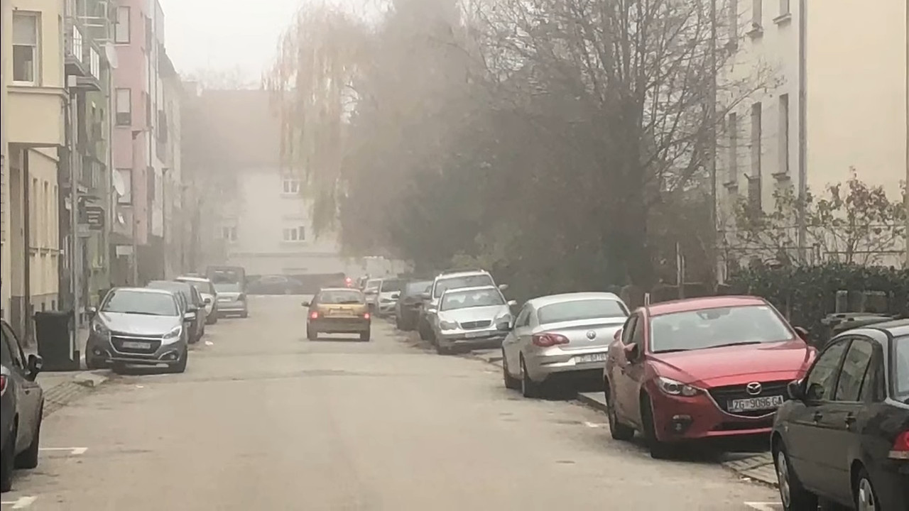
In the same way, I wouldn’t call illegal parking on the stretch of asphalt over the kerb which is unusable for pedestrians “a sidewalk”, no matter what initial idea might have been, as it cannot be used as a sidewalk by pedestrians walking.
Also note that we don’t know for sure what it was really intended to be, we can only guess: it might actually have been intended as a parking, or as a cycleway, or as a sidewalk, or as something else. Sure, some have (much) higher probabilities then others, but there is no way to be sure, as there is no current sign specifying, and trying to guess what it probably should’ve been fails Verifyability principle. Only things I am certain are:
So the only surely correct tags are:
highway=residential
sidewalk=no
cycleway=no
parking=no
What I would like is to add detail to indicate that something exists on the side of the kerbs, in order to avoid confusion (of mappers with opinion similar to yours) and avoid tagging mistakes (especially of armchair mappers) and provide extra details which might be useful in the future (for example, if city council decides that they should make a sidewalk or a cycleway there to improve traffic sustainability - is there enough space, and what are the expenses - e.g. is it only a few signs and a row of bollards / barriers to stop cars parking there, or if whole street need widening / reworking, etc.)
I though adding those details via disused:sidewalk=both, note=* and perhaps disused:sidewalk:left:width=* / disused:sidewalk:right:width=* would be more useful than not providing them.
Seriously? I’m not a native to that area, but if that isn’t a sidewalk, this country clearly builds them the same way as Germany. With kerbs. And lowered kerbs. And paving stones. We’re still talking about the first picture, right? Because that is a sidewalk, unless your city is building on-kerb parking spaces on raised kerbs ![]()
I don’t think we come to an agreement here: You don’t want to call it a sidewalk, for us this clearly is one. No need to discuss this any further.
Although I am impressed by the effort of @Matija_Nalis to find a suitable tagging for this situation, I have to agree to that. There are 2 sidewalks. The sidewalks are not “disused” but cannot be used as designed for by pedestrians due to objects placed all over the ways. If these objects are cars or pianos or fallen trees does not really matter, they are just any kind of object being obstacles to the pedestrians.
There is no fitting tag for this situation, whereas the problem seems to be existing in many places. See this recent topic about the same issue. So would it not be better to go the straight way and establish a new tag instead of trying to force existing tags into this gap - notwithstanding if actual routers may have a problem with it?
Um, my eyesight ain’t what it used to be, but where are you seeing paving stones on that first picture? I think that is an asphalt. And yes, over here, sometimes only difference between on-kerb parking, cycleway=track and sidewalk=left and might be coloring on the surface and/or a vertical sign.
So yes: in Croatia, that same illegal parking off the street on the first picture might tomorrow become legal car parking, or sidewalk, or cycleway – with only some paint involved, no other road works.
unless your city is building on-kerb parking spaces on raised kerbs
They do. I’m glad someone is having fun at that, as I guess our car drivers probably aren’t ![]()
and I agree with that quote completely. What I do not agree with is that something that is
disused:sidewalk(orabandoned:sidewalkorrazed:sidewalk) is actually the same thing assidewalk=yes, which (if I understand you correctly) you seem to imply.
yes, this is legally a sidewalk, constructed as a sidewalk and working as a sidewalk, and the only problem is there are parked cars to be expected, so you won’t be able to walk there, that’s a fact which is useful to know for pedestrian routing, but it doesn’t change that there is a sidewalk. You called it a sidewalk yourself.
sidewalk=yeswould be the trolltag for that case, as no usable sidewalk exists there.
no, because “currently usable” is not a criterion for the existence of the thing.
If I crushed a car under hydraulic press, would you still call that “a car” or “a lump of metal” ?
a better comparison would be a car without petrol. Is it still a car? IMHO yes, although it doesn’t currently drive.
If there is abandoned room in the ground floor of residential building where many years ago a shop was (but is no longer), would you still call (and map) that as a
shop=*ordisused:shop=*? I wouldn’t call it a shop, because I can’t buy anything there, which is a whole reason for mapping shops.
yes, this gets to the core of the issue, a shop in OpenStreetMap is about an activity, a sidewalk is not, it is about physical infrastructure. The building in your shop example remains a building, even if the shop is vacant (and all other areas in the building as well, if you like)
In the same way, I wouldn’t call illegal parking on the stretch of asphalt over the kerb which is unusable for pedestrians “a sidewalk”, no matter what initial idea might have been, as it cannot be used as a sidewalk by pedestrians walking.
frankly, the municipality should either declare the sidewalk a parking or tow all those cars.
Also note that we don’t know for sure what it was really intended to be, we can only guess: it might actually have been intended as a parking, or as a cycleway, or as a sidewalk, or as something else. Sure, some have (much) higher probabilities then others, but there is no way to be sure, as there is no current sign specifying,
are there generally signs for sidewalks in your country? I didn’t see them, sidewalks are very frequently not sign posted but evident from the layout and materials used (e.g. the kerb)
Yes, I wholeheartedly agree with you that it is the crux of the problem! ![]()
I strongly disagree however that “shop is about activity and sidewalk is NOT”.
To me, both are very much primarily (if not exclusively) about activities.
shop=* wasn’t about activity but physical space only, I’d mark it up as building:part=* and related tags instead.sidewalk=* wasn’t about activity but physical space only, I’d probably map it is an area=yes + surface=asphalt etc. instead (it would be better precision too!).What I am wondering, Would you consider for example highway=primary be about activity (i.e. driving motor vehicles over it, mostly) or about “physical infrastructure” only? In other words, if one were to map as highway=primary some way where NO vehicles could drive at ANY time, would that be OK in your reasoning?
And if you consider it is not OK to trolltag ways intended for vehicle movement in such way, why would it be OK to trolltag ways intended for pedestrian movement?
(Also, do you really never use sidewalk=* tag for pedastrian-movement-related activities, but only for some other things? Could you share which ones? And what do you think vast majority of OSM users use sidewalk=* for? I’d wager they use it for its primary purpose/activity, same as a shop=*, or amenity=parking or amenity=fuel)
That’s a poor comparison. highway= roads are a functional classification. You can certainly have =service and =footway with access=no . This is not trolling, or not a =service and =footway . A business may physically block them almost fully with their inventory and other junk on their premise, even for emergency exits very illegally and dangerously. That doesn’t mean such thing doesn’t exist.
What is meant by activity anyway? If a sidewalk is always almost fully occupied by street stalls or people sitting with their belongings spread out, is it not an intended use? You can still walk over them. If
(mis)using an existing tagging scheme rather than create new key/values seems like (mis)tagging for the routing software. ![]() .
.
With a new tag, local activists can survey roads, and campaign for changes in laws (or enforcement) and eventually get rid of the illegally parked cars.
But it is a criterion for prepending a disused: lifecycle prefix, is it not?
I kind of though it was the whole point to use existing tagging scheme so routers, renderers and other data consumers could use them? ![]()
About misusing, I agree with you. That is why I try hard to avoid misuse and to find reasonable solution which works (just read the whole thread if you believe I didn’t try enough). Only requirement is that the additional tag should not change a meaning or basic tag completely (i.e. it should not be trolltag).
For example, I do not find it acceptable to mark something as sidewalk=yes and then add sidewalk:unusable=yes, because such additional tag completely reverses the meaning of the first one, i.e. is a trolltag. Extra tags should just refine the meaning of the more primary tags, not revert them.
So I’m fine with any other (non-trolltag) options, like:
sidewalk=not_usable, orsidewalk=no + something_that_looks_like_a_sidewalk_but_is_not_usable_as_sidewalk=both, ordisused:sidewalk=bothSecondary goals are minimizing damage to the map by less experienced editors editing such ways (see iD-related discussion above) and minimizing amount of work other people will have to invest to implement the idea (ideally, the solution would be just something some volunteer can document on the wiki and others use, and no tools change is needed).
I agree, that would be nice extra benefit. But it cannot be overriding basic requirement that adding an extra tag must not reverse the meaning of previous tags.
That is why (to me) disused:sidewalk=both seems to perfectly describe the situation: it means there is an existing sidewalk on both sides, and it is not usable as a sidewalk. So it allows both for distinguishing existence (or not) of such spaces, and to distinguish space usable as sidewalk from those unusable as sidewalk. And it is already supported by editors, routers etc.
If you feel extra reason describing why it is currently unusable (i.e. disused) is important: sure, extra tag like disused:sidewalk:note=xxx (or better yet more often supported plain note) could added. Or some machine-readable equivalent like disused:sidewalk:reason=* with values like illegal_parking etc could be invented (although I personally am not convinced very many people would bother)
Because, that is exactly the purpose the lifecycle prefix disused: is intended for. It’s wiki (see above) even gives very similar use case as the part of main explanation of lifecycle prefix:
For example, a concrete parking area which is no longer used for parking cars but which still carries a name sign might be tagged as […]
disused:amenity=parking+disused:parking=surface+name=*
While it is certainly possible to invent other tag(s) to accomplish that same purpose (like unusable:sidewalk=both on nonfunctional_sidewalk=both etc.) I fail to see any advantage it might bring to the table (and see a lot of disadvantages, like people needing to add support for it everywhere). Or do you see some advantages which different naming (for about the same purpose) would bring?
In ordinary, everday language, there is a sidewalk here, and it is being used, it’s just that it’s being used for parking (obviously not its intended use).
How about sidewalk:use=illegal_parking? A sidewalk is physical infrastructure, like a building.
We don’t tag a church that is being used for something else than it was built for as disused:building=church. We tag it as building=church, building:use=apartments.
not for physical infrastructure, it is for services / activities.
Let me repeat my suggestion from above: obstacle
This is how we deal for example with paths that are overgrown and hardly usable.
If you think so, then it likely heavily differs by country or other. Over here, if you showed people first picture, and ask them wheather they see on the side of the road: (a) footway, (b) cycleway, or (c) (illegal) parking; vast majority of them would answer (c) (illegal) parking.
That is because it is not usable as (a) surface for movement of pedestrians nor as (b) surface for movement of bicycles, but it is being used as (c).
Note that sidewalk/footway is just a footpath (surface desgnated for movement of pedestrians) that happens to be situated on the side of the road, and is often (but not always) somehow physically separated from it (kerb, tree line, bollards…)
I’d prefer sidewalk=illegal_parking (or more general sidewalk=not_usable) as it would lessen the most problematic possibility that someone who has not taken the time to read this discussion might naively add sidewalk=yes in addition to that sidewalk:use=illegal_parking, thus breaking everything for pedestrians)
A sidewalk is physical infrastructure, like a building.
I disagree. What would you call this thing on the left side of the road? sidewalk or cycleway?
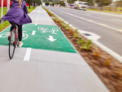
I would most certainly call it a cycleway, as it is designated surface for movement of bicycles, and pedestrian traffic is not allowed. Thus, I would tag that highway=residential with additional cycleway:left=track + sidewalk=no . I’m very interested how would you tag it @osmuser63783 and @dieterdreist (and others)?
Yet, physically, it might have been footway/sidewalk instead (for example, if that image was taken from slightly different position, you might likely guess wrongly).
In other words, just because there is paved area separated by kerbs on the side of the road, does NOT automatically make it sidewalk. Sidewalk implies specific purpose (designated pedestrian traffic).
And this is why ultimately the local community has the final say in how various objects are represented, even if that does not mesh perfectly well with what is perceived otherwise to be the general standard. Thinking on your post, it is very true that the cultural idea of what constitutes a sidewalk vary greatly. I myself have experience with two types of ‘sidewalks’: in Brasil and United States. They could not be more different than each other. I wish you all the best in your efforts to find a tag combination that works to represent this situation @Matija_Nalis.
That’s a false dichotomy: it’s (a) and (c). It’s called parking on the pavement where I live, it’s not uncommon. I don’t think anyone would claim that that means there isn’t a pavement.
Same as you, of course. I wasn’t trying to make an argument that any paved area next to a road is a sidewalk/pavement.
I completely agree: this is the key question. Is it designated (intended, set aside in legislation) for pedestrian use? I think this discussion has shown that those who answer “yes” find it hard to support any suggestion that includes “sidewalk=no”.
Amen to that. Maybe it’s all down to regional/cultural differences. No one prevents you from tagging it as you wish, even if many people who have participated here would tag it differently. ![]()
Edit:
Not a bad idea in my view. Neither both nor no. Hopefully deters routers, but also deters retagging as both.
But how do you know it is (a) and (c), and not (b) and (c)? At least in my country, only indication if it was originally intended as (a) or (b) is that there will be painted picture of the bicycle every 100 meters or so. Without removing all illegally parked vehicles, you simply couldn’t know. Only thing that all people could at a glance agree is that it is (c) (illegal) parking.
In other words @osmuser63783 and @dieterdreist, why would you decide to mark that as sidewalk=both instead of cycleway=both ?
Or it might even be the combination (even most probably in some countries) sidewalk:left=not_usable + cycleway:right=not_usable (or the other way around).
Thanks, I hope others see it the same way - this is what I want to point out. If you don’t actually know what is on that side of the kerb, is it OK to invent some meaning without any evidence just because you made a random guess what it might have originally being designed as?
So,
if one insist on mapping “physical feature” instead of “current usage” (which seems to me to be the division in opinions here), then, for example, one could map that picture at top as a cycleway=right + sidewalk=left. Or as a cycleway=both + sidewalk=no. Or as a sidewalk=both+cycleway=no. Or few other combinations, which might (but need not) actually be true.
To me, such ambiguity which is “resolved” only by guessing fails Verifiability principle. We would instead need some tag which means “paved surface on the side of the road without any physically possible usage, and with unknown legally intended usage”. I would argue that neither cycleway nor sidewalk are that tag, as they have their meaning (dedicated surface for movement of bicycles / pedestrians, respectively). Maybe something along the lines of undefined_raised_surface=both/left/right would be most precise?
on the other hand, if one insist on mapping “current usage” instead of “physical feature”, situation is much clearer - it is certainly sidewalk=no and cycleway=no, as they don’t fulfill those purpose. It also (as opposed to above option) actually works for one of the most popular uses of OSM, which is routing. It might also additionally be tagged with undefined_raised_surface=both/left/right or similar (like disused:sidewalk=both – note that while it might also be partially incorrect, difference between “unusable sidewalk” and “unusable cycleway” is not really all that important; as opposed to difference between “sidewalk” and “cycleway” where difference is a huge deal)
Yes, sidewalk=not_usable would certainly confuse much less routers than sidewalk=yes + sidewalk:usable=no, but it is still less than ideal, as work would be needed to verify/patch all routers and patch all editors…
e.g. less complex routers will still check only for sidewalk!=no and decide that other values mean OK to route - so all of sidewalk=left, sidewalk=right, sidewalk=both, sidewalk=separate, sidewalk:left=yes, sidewalk:right=separated etc. would mean it is OK to route pedestrians there
A sidewalk is physical infrastructure, like a building.
I disagree. What would you call this thing on the left side of the road?
sidewalkorcycleway?
cycleways are also physical infrastructure
Cycling on the pavement is never legal in the UK unless there’s a blue “shared use” sign. Pavements that are only for cyclists (which would of course be mapped with cycleway=* not sidewalk=*) virtually don’t exist. The only one I’ve seen had a dropped kerb connecting it to an on-road cycle lane, in addition to bicycle symbols. That would be easy to spot even if it was blocked.
By the way, sidewalk=bad has 20 uses, in case you don’t want to start completely from scratch.