From my understanding of the wiki, noexit=yes nodes should be located at the end of a road segment, hence should not be interconnected with other road segments. The gap visualization is useful for renderers and allows more details to be added at a later stage (like a wall).
Surprisingly, no JOSM validations errors are thrown. Is this combined noexit=yes interconnecting multiple road segments valid for routing purposes?
I would put a noexit at both ends if there is no visible barrier in between but only a piece of meadow or similar. Since the road is connected here (without the barrier), I would also connect the road and only a single node on the barrier.
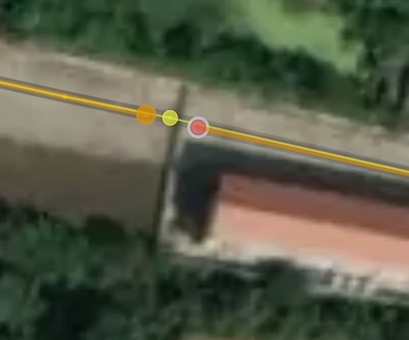
From the aerial view alone, it’s anyone’s guess, but I’d lean toward a jersey barrier with material=concrete. (And no noexit=yes at all.)
A router should be able to interpret the barrier correctly and consider it for routing.
If a pedestrian can pass sideways here, (which looks like north of the barrier) I would set a foot=yes. (And then a noexit=yes would indeed be wrong).
To me, this would indeed be a misuse of noexit, but I still think that the roads should be merged.
I agree with how the wiki presents noexit=yes: as a supplementary tag that removes ambiguity from valid drawing. In other words, the data is still correct if you ignore the tag. Merging the node also seems incorrect for other reasons, e.g. mapping a wall between the two roads as you mentioned.
However, following mcliquid’s thoughtful suggestion that this might not be a noexit after all, I believe that the addition of noexit=yes in 2021 was incorrect, and there should actually be a single way with a barrier node.
@SupanchatMetta perhaps you didn’t notice (or didn’t understand) the noexit=yes tag when you connected the two roads?
Apologies, google street view shows indeed some kind of gates. So in this specific case merging segments makes total sense (barrier=yes instead of noexit=yes)
However, in Thailand walls are very common between different developments, and I was wondering in general if segments with a valid noexit=yes should be kept disconnected (which I understand is yes)
There is no wall because there is no shade. Connect the roads with barrier=yes on the node. You can’t add any more tags because it’s not known who or what can pass the barrier.
If the wall only spans within the width of the road, then it makes sense to map it as a barrier= on the road. However, if the fence is wider than the road, it seems more logical to have two separate roads split by the wall. It looks like the former case applies here, but maybe not - I haven’t visited the site to know for sure.
If the gap between the roads is passable on foot, noexit=yes won’t work, but there’s also nothing preventing the road from being split without noexit=yes on each end (and even adding a highway=path to represent the pedestrian path between the roads).
Yes, if there is outright wall splitting roads then road line should end (with optional noexit=yes), separate barrier=wall line drawn and the same on the other side. The same for other barriers or blockers, with appropriate tagging for the barrier.
Continued line or two road lines joining with barrier would look like incomplete gate tagging:
If there is a gate then road should intersect wall with barrier=gate on a shared node (which ideally would have also access tags).
If there is path/cycleway between roads allowing limited passage: then such connector should be mapped.
I don’t agree. From the imagery it’s not clear if it’s a road with a wall built upon it, or if it’s a wall and there are two separate roads built untill the wall ends them.
Both can be true and in the first case I would map a road with a node in the middle. I would tag the node with
barrier=wall
access=no (depending on if or not anything can pass)
As a matter of fact the imagery indicates there is no wall, because there is no visible shadow. Compare with the shadow of the house.