The response you got from the github issue explains quite nicely how Nominatim handles postcodes.
Setting up boundary=postal_code relations to define areas for each postal code is a complex task and most probably require a lot of manual effort.
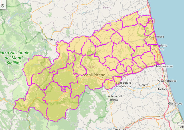
There are some existing examples in Italy: https://overpass-turbo.eu/s/1zAf
In case existing admin boundary aligns perfectly with postal code boundary you can also use postal_code tag directly: https://overpass-turbo.eu/s/1zAg
Both of these approaches are opposite of easy and fast imports that you mentioned in your first post.
Only easy solution would be to verify if the existing 2.2 million addr nodes have correct postal code. If not, updating addr:postcode tag is fairly straightforward task.
I added a pair of “postal_code” to OSM DB and seems your Overpass script now detects it well.
I need to check and verify if Nominatim will use this new tag or rely only to “addr:postcode” of single OSM entities (nodes, ways, etc…)
Can see a cross-check botomania of CAP zones whence verified being used to check up on the CAP codes on addresses within each area. My town has 9 or 10 CAP codes so drawing that may be some work though I suspect some or all are aligned with the named neighborhoods, something which is not the case in Germany, a complicated business over there.
Are you able to read what I ALREADY answered you (at that link) 2 days ago (first answer)?
In the only safe way: by accessing municipality’s website and usually, at the bottom (or in the “Contacts”/“Contact us”) you can find the address and its postcode.
It is no coincidence that in 4 hours it is not possible to carry out more than 100/120 censuses.
PS: ce la facciamo ad accendere il neruone caro Copiatore Andrea o non ti è andata giù la mia osservazione per Mapillary?
Unluckily the answer where not friendly at all.
I had already answered you but you continued to bother me, so…
Please go on insulting me: “ce la facciamo ad accendere il neurone”, “non so come aiutarti se non prenotandoti una visitina dall’oculista e pure dallo psicanalista per l’evidente difficoltà nel comprenderla”. Really mature.
It’s not an insult, but you continue to bother me.
I already answered TWO DAYS ago but 1 hours ago you wrote that I didn’t do it.
So yes, maybe a clinical check for your eyes could helps you to find my answer at that link.
Can I choose another path or, once I have declared something, am I forced to do it?
Uploading open dataset is not safe and I don’t want to study how to use OSM API from Python/Java to do a massive upload.
So I’m not interested more in this procedure and I do it manually by myself in my free time when I want to do something repetitive for my relax.
Closing this topic because it is becoming too heated and has degenerated into name-calling.
The question of whether Mapillary data may be used in mapping OSM was settled long ago and should not be a matter of dispute. Anybody who questions that is welcome to read the wiki article at Mapillary - OpenStreetMap Wiki as well as the Mapillary website statement on use in OSM at Images and Data for OpenStreetMap.
I have flagged the changeset in question for the DWG to examine and to be alert to any edit war that anyone may be contemplating.
Reopening the topic by request. Please keep all posts civil and in accord with the Etiquette Guidelines. No ad hominem attacks, just address the issues. Thank you.
If this is not a rare edge case, I would be careful with these admin boundary edits. Additionally, if you are using Mapillary as source then it’s almost impossible to verify if there is more than one postal code used in a given area.
Few big cities have multiple Postal Codes but 99% of 7904 “hamlets” (it’s not the right word in italian, but I’m using it to try to explain me) follow the rule of “postal code is aligned with boundary”.
I’m not using Mapillary. I never hear about it until few days ago.
I’m using normal JOSM.
If you can somehow distinguish what regions only have a single postal code and if your source (it would be helpful if could specify it) has ref:ISTAT code, you theoretically could perform a mechanical edit/import to add all these postal codes to OSM. But this does require some documentation and local discussion first.
It’s not a whole Region but neither an small Hamlet. In italian they’re called “Comuni” but I can’t translate it in english to let you understand better.
Each Region contains one or more Provinces which contains one or more “Comuni”…and each of them contains one or more Hamlets.
For example: Rome is simultaneously a Capital, a Province, a City and one of those Comuni, but this last one’s area is smaller than “Rome as a City” or “as a Province”. PostalCodes here in Italy belongs to these “Comuni” which are boundaries with administrative=8.