Generally, my impression is that “testing locally” isn’t really feasible or usually done with OpenStreetMap these days. Exceptions could include big data users, but for individual editors, the usual way I’ve assumed is to try to get it as decent as possible, upload, then see how it works in the tools once they index in your change, and make adjustments if necessary. It’s a very iterative-improvement process, but I feel that works with the ethos of OSM in general.
I think we can wrap this by stating which method we prefer/suggest for each scenario. I’ll start with my suggestion, which is the method I use since 2020 I would say:
-
draw as a separate cycleway when: there is a clear separation (like a permanent parking lane, bollards, fence, or concrete curbs at intersections or along the whole way), or a clear change in surface (concrete surface instead or paving stones alongside an asphalt road)
-
add cycleway tags to the road itself when: there is only paint all the way (barred area and/or solid/dashed/dotted lane, green/blue paint with no physical separation, or flex posts which can be removed easily (usually in winter, and sometimes they put them back only late in the spring or in the summer), and no concrete/fence at intersection.
So as a summary:
- draw as a separate cycleway when there is partial (only intersections or short segments) or complete PERMANENT/NOT SEASONAL physical separation
- use cycleway tag on road otherwise (including flex posts)
I would word this as:
- draw as a separate cycleway when there is substantial (most of the route) or complete PERMANENT/NOT SEASONAL physical separation
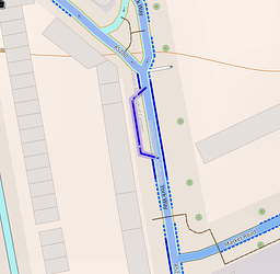
Otherwise we could get into nonsense 5 metre long cycleways like this stuff in London (England):
I would also like to have an official recommendation/requirement to add the street name as the cycleway’s name as well. You do this in Montreal, but it’s not done in Toronto and I’d like to start seeing that.
Yes, merging/unmerging from separate cycleway to road cycleway tags should not be done unless there is at least 100m or so. Otherwise, keep the previous method. THat is why the REV should use the separate method all the way, to make sure there is no merging repetition between each intersection.
Do you intend to document your proposal in a place where Canadian contributors can easily find it? I hope so ![]() and where will it be?
and where will it be?
I’ll wait for more responses, but once it is assessed I will put it in the official wiki Canadian page with a link to this thread.
See Canada - OpenStreetMap Wiki (added official guidelines for tagging cycleways)
Also added to this page:
https://wiki.openstreetmap.org/wiki/Canada/Tagging_guidelines#Cycling
