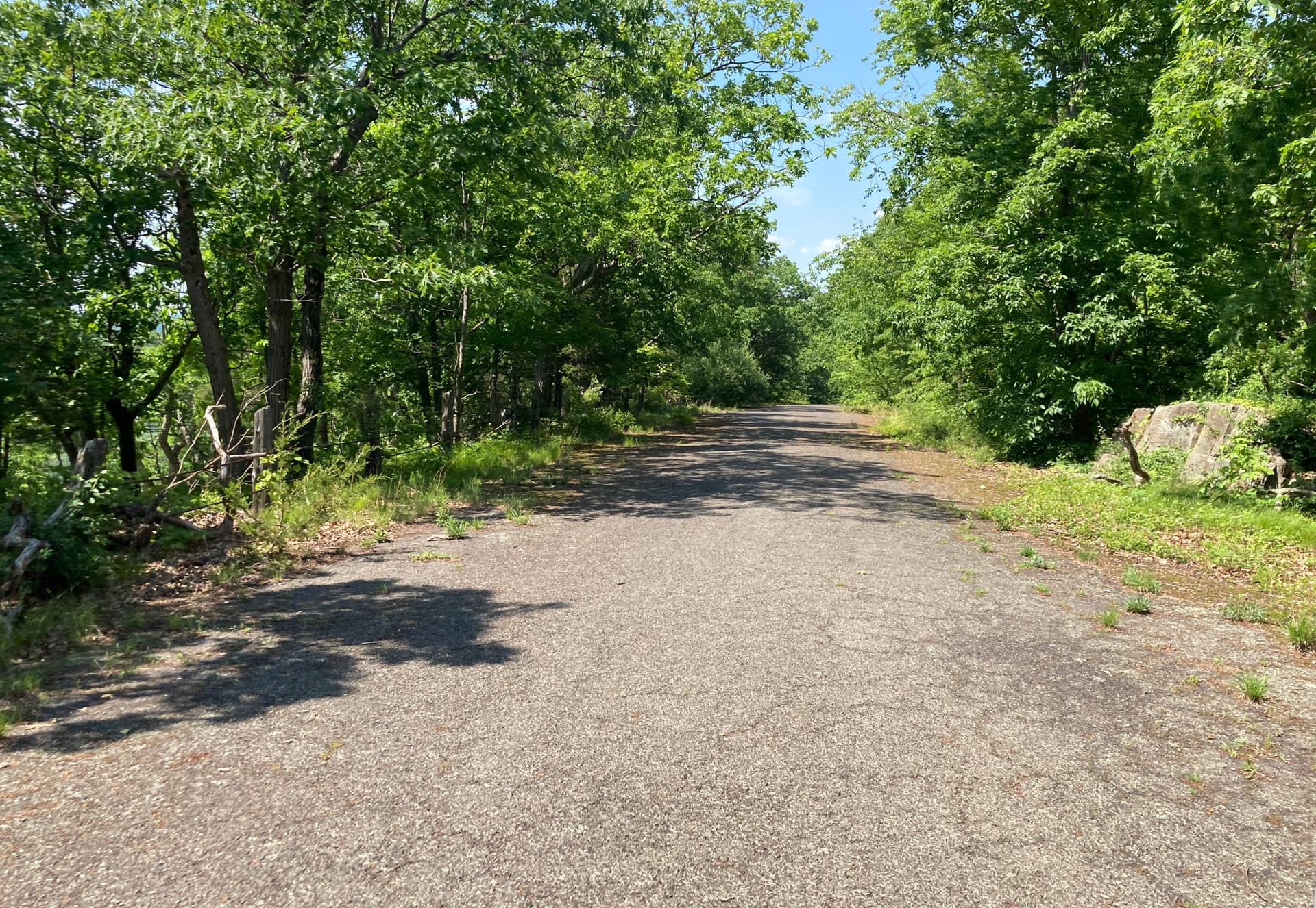
There is a local paved road, a ~6mi/10km scenic drive along a mountain ridge, that used to be open to cars but has only been open to pedestrians and cyclists for decades now. It was tagged as highway=pedestrian, which I thought to be correct, but someone recently changed it to highway=unclassified, saying that highway=pedestrian should be used for more typical urban pedestrian roads.
The wiki on one hand says that it does typically describe urban pedestrian roads…but that makes sense because rural pedestrian roads are relatively uncommon. Unclassified doesn’t seem quite right either because its wiki page says it should only be used on public roads open to cars, and instead suggests service…but it isn’t really a service road either. I mean, there is a communications mast near the start of it, but the road really was built originally as a scenic drive.
someone recently changed it to highway=unclassified
that is completely and utterly wrong - changing it to highway=path or highway=track could be defended. highway=unclassified is blatantly, totally, completely, ragingly and utterly wrong given “has only been open to pedestrians and cyclists for decades now”.
saying that highway=pedestrian should be used for more typical urban pedestrian roads.
I am using highway=pedestrian in such settings, but some people disputed this. But it is definitely more correct than highway=unclassified
If someone will continue putting highway=unclassified there - then feel free to link this location.
From looking at photo I would consider highway=tracktracktype=grade1surface=asphaltvehicle=nobicycle=yes and this would be likely typical tagging. Is there at least occasional forestry/logging/service traffic? Then it would be vehicle=private or vehicle=forestry
But highway=pedestrianbicycle=yes seems fine, if there is extremely heavy pedestrian traffic and basically zero vehicle traffic (only emergency vehicles).
It would be my choice, likely. highway=pedestrian is not limited to urban settings. For a former road that is now closed to motor vehicles, pedestrian seems the best tag.
Looking at the picture, track also could be suitable (depending on exceptions that exist or not, for vehicles)
For me, it is a wide highway=path or a highway=track.
I see highway=pedestrian more or less in urban areas only, even more strict: those with an appropriate traffic sign “pedestrian zone” (“Fußgängerzone”), as can be seen in shopping areas in the centre of a city.
So, I’m quite careful with applying this to roads (or even wide sidewalks that tend to have a shape like a square).
I sometimes see people adding highway=pedestrian tags to small footways inside a pedestrian area. IMHO this is not correct, pedestrian highways must be physically wide enough for at least regular motorcars (typically also for lorries, e.g. garbage collection). There is no 1:1 relation between highway=pedestrian and every way in a pedestrian area.
The bit missing in this discussion is the actual sign posting / detailed access restrictions (highway=unclassified will be wrong in any case). For example if it continues to be used for forest management and similar purposes highway=track might be appropriate.
It’s in a state park, no logging. I’ve ridden it about 50 times and have never seen a motor vehicle on it. After 1km there is a communications mast, but nothing after that. It looks pretty much like the photo. Actually, at the northern terminus, there’s a large pile of dirt over the road so it wouldn’t be possible to drive a car through the whole thing anyway.
No signs – only a locked swing gate at the start with a foot/bike-width side entrance.
Other people may disagree with this, but I think highway=living_street would also work here. I tend to think of living streets being ones where pedestrian activity is the dominant mode even if it wasn’t built as a pedestrian street immediately (The argument against this would be that something has to be officially designated as one to count as this, but in so much of the world legal designations do not dictate who uses a road.) Track and pedestrian street are good options too, although I would lean towards track because I tend to think of a purpose built pedestrian street as having various paved surface features (like paving stones, tactile paving, concrete etc).
The wiki isn’t great in the way it defines road types. Part of the problem with defining them just bases on mode of transportation is that in some parts of the world, cars only make up a small proportion of the overall transportation. However, it doesn’t really make sense to reclassify entire countries that use “regular” highway tags on roads cars can’t drive on, because that isn’t useful within the context of a place where that is considered the default. The rule of thumb I try to keep in mind is just what would be the least surprising way to see this presented to people in the area?
The thing that makes following this tricky is that in places where the city was built before people started using cars, “regular” streets didn’t even have to be wide enough for them.
The way I tend to use highway=pedestrian as opposed to a footway is for streets which have signed names and/or buildings with addresses with that street name. You would not be able to drive on any of these, one of them is even mostly a staircase. This is how my city defines pedestrian streets though, so it makes sense in that context, and a street isn’t necessarily seen as something that needs to be used by cars.
I am also frequently mapping in areas with many “streets” not suitable for cars, but I like to represent the structure by giving the larger ones the pedestrian class and those too narrow for a car footway, it’s not as finegrained as road classes but at least it offers 2 classes for foot traffic.
That definitely makes sense. Some neighborhoods where I map have named foot path networks which are seen as different even from pedestrian streets that are as narrow as paths, so I try to go along with that. I think where the distinction lies there is whether or not it only connects destinations (path) or if it is a destination in itself because it has houses or businesses (street).
There are a couple of weird situations where you have to mark a way that even has “path” in the name as a regular street for cars because its been treated with asphalt and had garages added along it, or a way that has “street” or similar in the name as a path because it is unpaved and hard enough to see that you might have trouble finding it even with a street sign.
highway=living_street is an exception to the rule in highway tagging and is closely linked to specific legislation, I don’t believe it should be used outside of that context as the potential for confusion and dilution of its meaning is quite large.
So it can opened for use by authorized personnel, IMHO clearly highway=track tracktype=grade1 and the barrier should be added with appropriate access tags (probably you should add the barrier at the other end too if permanent enough).
this one corresponds to specific legal situation - where both vehicles and pedestrians are allowed, but vehicles must give way and pedestrians are allowed on entire road
here vehicles are banned, therefore this is not highway=living_street
If it’s in a state park, there are likely park rules about where motorcycles and horses can go, irrespective of any signs at the road/trail/path itself.
From the picture and the details given, if this was in the area of my local knowledge, such, right from the start, would have been tagged “highway=track;grade=1” and a suitable “motor vehicle=private|…” (Motor, because you said, you rode it, and I infer bicycles allowed, Private because of the locked swing gate.) Nobody here would change that to “pedestrian” or “unclassified”.
If you want to keep this available for cycling in most routers, a swing gate is prohibitive of that. I do not know, if “bicycle=yes” on it will remedy that, or a small footway around the gate is necessary?
Risking to get off-topic: This gate here Node: 414721082 | OpenStreetMap did not allow me to cycle-route past it in OSRM and graph-hopper. The footway around it does exist OTG, BTW. Now, it does not route cyclists, because I added an access tag on the path. But before, only the gate kept cyclists out.
Curiously, it did not stop the Bosch E-Bike Navi App and that lead to a nice encounter
PS: This swing gate here does not block cycle-routing Node: 9760730447 | OpenStreetMap - should be in the data for long enough. So bicycle=yes seems to make a difference, from what I observe. Or is it the access on the track, that makes the difference? IIRC, access should be set on the ways, not the gates.
But I suppose I’m still unclear about the highway=pedestrian tag – authorized personnel in motor vehicles are also allowed on those usually. The wiki page has a photo example of a road through a cemetery, which isn’t particularly urban…so what is the cut-off point of urban-ness? Like how about this other road closed to cars through a smaller city park, should this also be changed to highway=track?
In parts of the U.S. where I typically map, highway=pedestrian only appears on pedestrian malls in urban areas, the sort of path that looks like a hole in renderers that don’t render that tag. The streets around this market in Cincinnati are mainly reserved for pedestrians. Cars are allowed in during some hours for street parking and deliveries, but that’s an exception rather than the rule; the street still has the feel of a pedestrian mall.
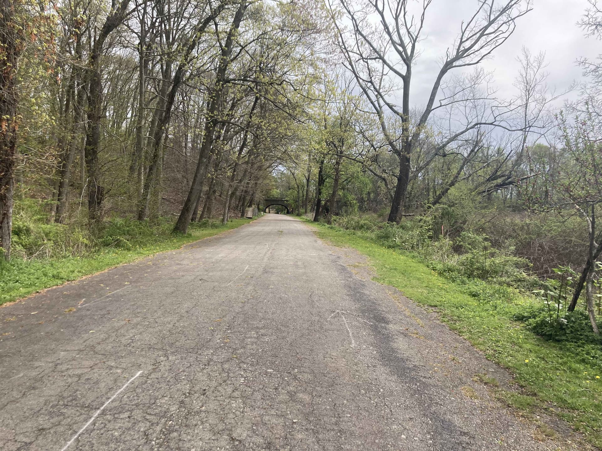
Apart from urban examples like that, local roads that have been converted to non-motorized traffic have gotten tagged as highway=cycleway or highway=footway (with appropriate access tags) depending on whether they’re considered bike paths or walking trails, and highway=path for less tidy trails. For example, this passage through a covered bridge is tagged highway=footway. The bridge was moved from its original location to a park. The bridge deck has been preserved just as it was when it was part of a roadway, but it no longer functions as a roadway. Tagging it as a roadway with access overrides would feel a bit like laying a trap for data consumers.
I can understand the desire to tag your longer examples as something more substantial than a highway=footway. If I came across this trail and it was tagged as a highway=pedestrian or highway=unclassified, I’d make sure other tags clarify the situation well but otherwise wouldn’t lose much sleep over it.