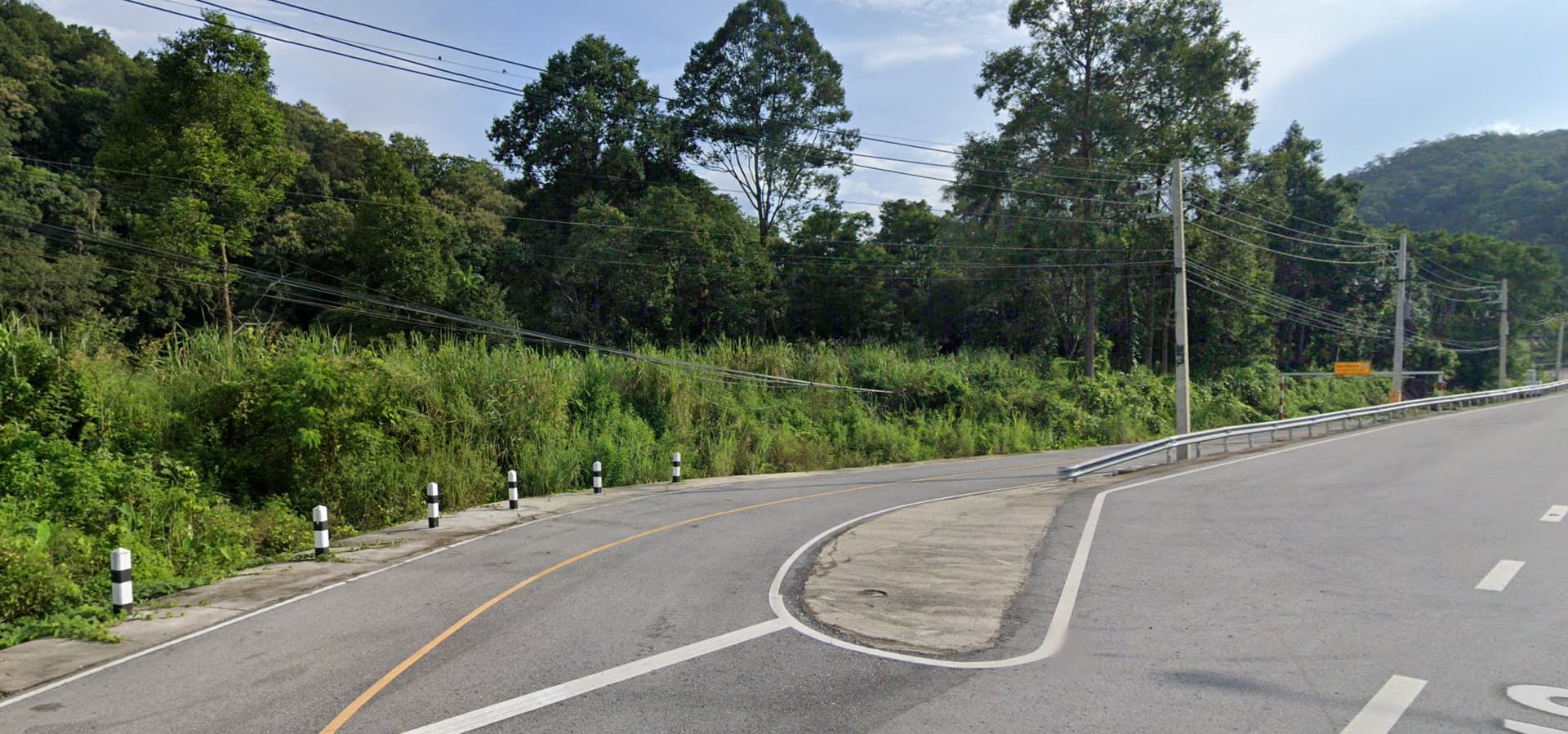
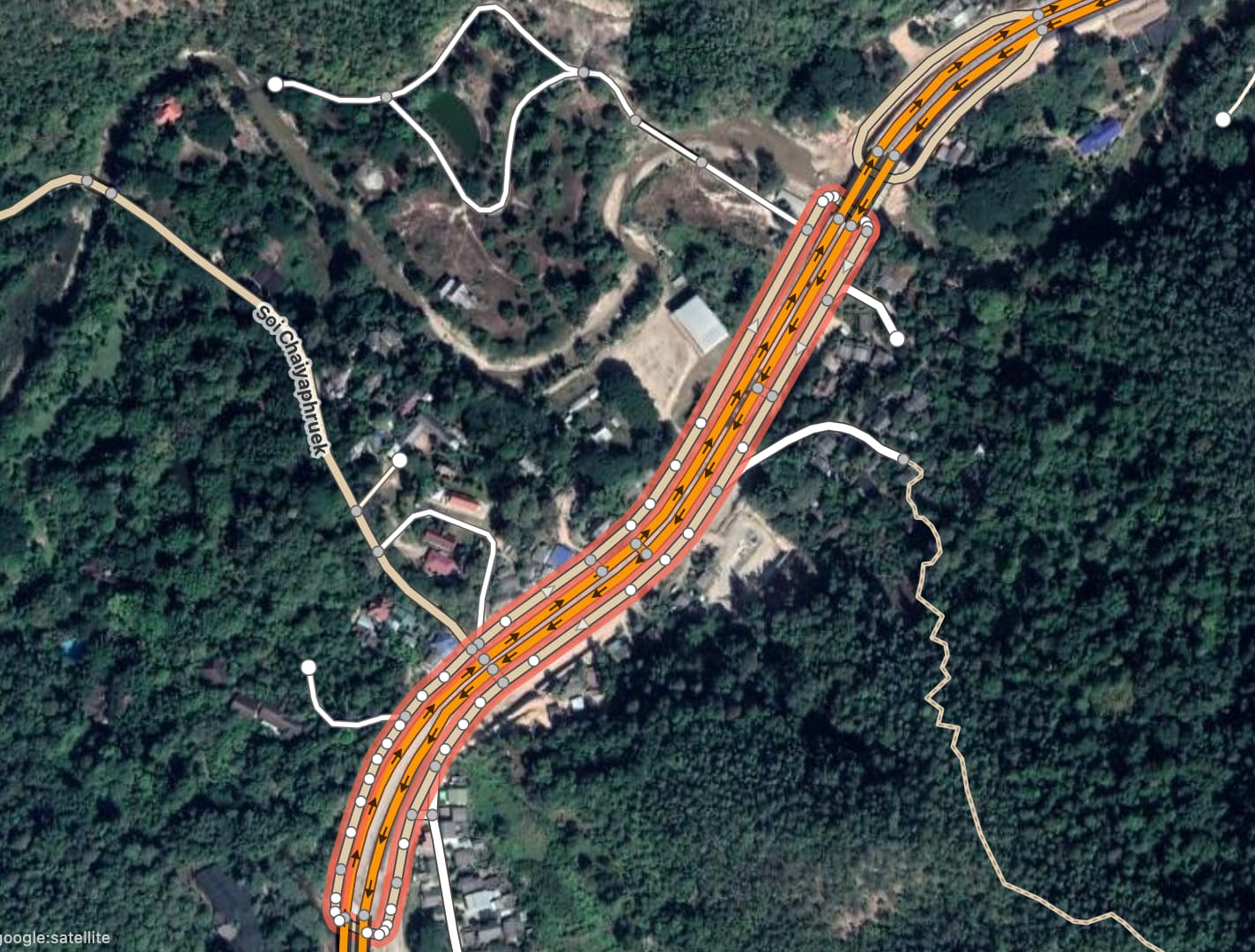
Learning more about highway links and looking for clarifications on whether the definition would fit these unusual 2-way u-turn access roads along a primary highway in Thailand.
These were built recently during the upgrade of the main primary highway between Chiang Mai and Chiang Rai. There are a dozen of them along the highway.
Their sole or main purpose is to provide u-turn access in both directions. Lanes are marked with a yellow line separation.
In some cases, some provide access to a farm track, a few properties, or even a side road giving access to a settlement.
Would these u-turn road segment qualify or not for primary_link, and why?
Never seen it done like that, but yes, they would be fine as primary_links. You’ll also have to include a bridge segment on the highway, where it crosses over the top of the link roads.
Fascinating! I’ll agree highway=primary_link works for these “slip roads.” The phrase “slip roads” is not deeply familiar to my dialect of English (I’m in the USA) but as I’ve seen it used in OSM since the 2000s, it looks like these are a sort of “slip roads” on a highway=primary road, so, yes, highway=primary_link works for me. Where it might turn into a (perhaps unpaved) track to a farm or an isolated settlement or whatever, maybe it becomes a highway=unclassified, or whatever; adjust “further” tags accordingly.
And yes, do some careful bridge tagging where appropriate, with layer=1 and bridge=yes and maybe bridge:name=* if there is one. Cool!
The primary_link tag makes sense for me for the short sections, but wouldn’t the larger ones giving access to side properties be considered “frontage roads”, and require a different tagging strategy?
Nice screen capture, makes it fairly clear what you ask. Truly, I defer to where you decide this “correct place” where the “right off the highway” gets highway=primary_link and then that “turns into what is essentially a frontage road,” which might be a highway=unclassified perhaps. Then again (or maybe not), where you might get (looks rural and hence quite quickly / short distance) it goes to highway=track or highway=residential if either of those are “most correct.” Maybe something like “up to the first intersection.” That’s actually rather common, as are an accompanying either stop/yield sign and/or signal.
I like the way this is an interactive dialog with pictures and (maybe a bit slow, I’m OK with that) participation and opinions / perspectives. It’s “good community” to dialog like this.
A “frontage road” (a parallel-to-trunk/motorway, lower-speed, free- not limited-access / non-motorway highway) might be any of unclassified, tertiary, secondary, primary or (it would be quite rare, but possible, I think) even residential. Those choices fit into “mostly as our wiki defines them,” with some wiggle room for “that’s how our hierarchy is around here.” So, where you “feather the edge” away from primary_link to unclassified or whatever, that’s “best up to you and locals who have something to say about road hierarchy” (below motorway and how it all “fans out” across a region). Such a “frontage road” is how you define such things “parallel-to-trunk/motorway” in Thailand.
You might decide to call the “median crossing” segments as link (I would) and others “up to a certain point.” Where is that? Up to you, but not “forever.”
So far, looks good in Thailand here. If you or someone were to “tighten up” or “feather an edge” as I describe, especially as the rest of us continue to nod our heads, I’ll nod my head: to me, so far, looks good. Thanks again for a nice graphic and clear questions.
Note that there are two distinct concepts that are both called “frontage road” in some dialects of English but need to be tagged differently.
frontage_road=yes has been used extensively for the system of surface streets that parallels (and often predates) a motorway, providing access to both the motorway and abutters. These are called “frontage roads” in Texas, where they’re especially common, but they may go by other names in other places, such as “service road” or “access road”. This key is relatively unimportant from a routing perspective, so mappers in other regions have been content to just classify them as unclassified roads and call it a day.
Separately, side_road=yes is for a separate carriageway of the main road that provides access to abutters but does not serve as a through street. In some dialects, these are called frontage lanes to distinguish them from the other kind of frontage road, but most people don’t even have a word for this. Routers need a tag to avoid frontage lanes because geometrically they’re so similar to the main road, creating noise in map matching and route guidance. Depending on the region, mappers make the classification match the main carriageway or use highway=service; they either give it the same name as the main carriageway or no name at all.
For full disclosure, I’ve reverted changes to the relevant wiki pages on a few occasions. I’m not a huge fan of these poorly named keys, but it’s important for mappers to understand what the keys have been used for before cowboy-editing the documentation to suit their own dialect. Editing the wiki doesn’t automatically update the database or any data consumers that rely on it.
I have some idea of what you mean by “cowboy,” though I do ask for a plain-language definition. Do you mean “run roughshod over existing documentation” (without well-consulting the wider community)? (And even using the word “roughshod” feels odd, one of those archaic words that popped into my head, so I looked it up and it’s when a horse has its shoes deliberately left with nailheads protruding to improve traction, but it can tear up softer pavements. So, “tearin’ up the documentation” with “cowboy” attitudes of ignoring everyone else? Is that close?)
When you say “poorly named keys” do you eschew (even quietly) OSM’s “any tag you like” options? Would going through a formal proposal be preferred to “coining” a tag (like side_road=yes)? That seems a bit extreme. How might one who coins a key or tag know if something might be poorly named?
And it can be tricky to be a wiki author (as you know): how much of what one might write into wiki is “original research” (in the capital-W Wikipedia, that’s a no-no, I believe, though I don’t contribute there) and how much is “just the facts, on the ground (or in the map) as I see them”? The latter are more welcome, but how is one to know that’s how wiki were authored / edited? (Rather big and rhetorical, I know…doesn’t require a master’s-thesis-level answer, of course).
Thanks in advance. Your knowledge of things as seemingly obscure as “Texas frontage roads” (and how they are different, historically, linguistically, highway-and-roadway-historically…) and other related topics (more-easily searchable via taginfo and other usage, like side_road=yes) continues to impress me! I’ve said it many times: OSM is full of sparkling people who know and do amazing things.
On a few occasions, mappers have completely rewritten or completely inverted the meaning of these two wiki pages after they jumped to conclusions about the subject based on their own dialect’s terms. As far as I can tell, there was no discussion beforehand.
It’s as if someone from the U.S. unilaterally rewrites the highway=motorway page to be about raceways and rewrites the highway=raceway page to say it’s a less common synonym, purely because that’s what “motorway” means in their regional dialect. Obviously, such an edit would have no impact on most existing motorways or data consumers that interpret them. But it would cause plenty of confusion for new mappers and would be a disservice to the community.
Sometimes the wiki is wrong, and sometimes the tagging scheme is poorly designed. But there’s more to fixing these problems than unilaterally changing the documentation to sound right personally. At least the problems should be acknowledged in the text.
Going back on topic, perhaps these examples from Russia and the U.S. would be helpful in deciding whether the screenshot above shows frontage roads, frontage lanes, or something else entirely.