На територии Непала 12 часов назад замапили 3,5 миллиардную точку ![]()
I see that the helper in Nepal very seldom use tag: place=village and place=hamlet.
This cathegory can be used for search.
I use in Nepal place=hamlet for settlements with 10-12 buildings, if more, I use village.
The official list of villages is probably not complete there. So, when we use this description we make probably no or very less mistakes.
Bill Gates likes OSM ![]()
This area: http://www.openstreetmap.org/edit?editor=potlatch2#map=16/27.7935/83.4745
and around this area:
There is no buildings.
А что это?
Эти деревни. Cпасибо iWowik.
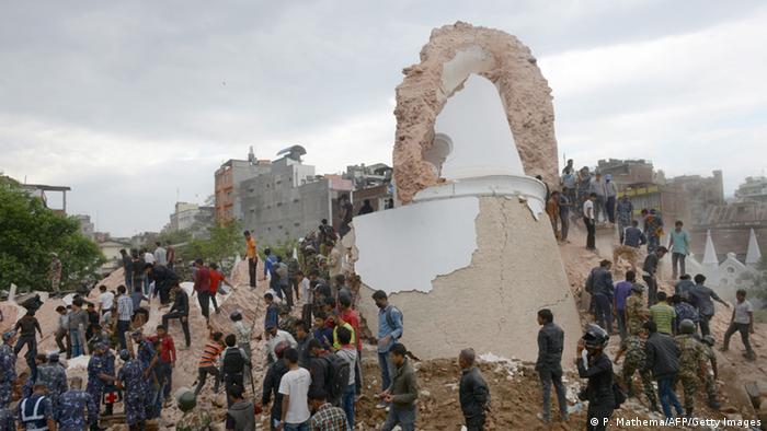
Опять стряслось, магнитуда 7.3
http://ria.ru/world/20150512/1063995528.html
Вот тут: http://earthquake.usgs.gov/earthquakes/eventpage/us20002ejl#general_summary
We have in this epicentrum area also missing information in the map, especially forests.
До
После
Here : http://tasks.hotosm.org/project/1046#task/603
are areas still open. Validation / controll is neccessary.
Maybe some of you can help here?
Best regards,
Marek
I´m tired ater long mapping; coud somebody of you draw the forest here: http://www.openstreetmap.org/#map=16/27.6893/86.1348
Also area river and sand along the river as natural=scree
Thank you!
Marek
Thank you all!!! This statistic for Russian help in Nepal is impressiv: https://twitter.com/AhmedLoaiAli/status/599206255387893760
This area is very poor mapped:
http://www.openstreetmap.org/#map=13/26.9388/87.3368
Regards,
Marek
There are four new HOT tasks for Nepal:
http://tasks.hotosm.org/project/1070
http://tasks.hotosm.org/project/1071
http://tasks.hotosm.org/project/1072
http://tasks.hotosm.org/project/1073
Could you help?
With regards,
Marek
This is the message from Kathmandu Living Labs:
Hi all,
Due to the rain yesterday there was a massive landslide that swept away an entire Village in Myagdi district. This landslide has created an artificial dam which is already risen to 150 meters and is already 1 km long. A village upstream have been completely submerged.
There is a huge risk that this dam might burst as we are still having heavy rain and also the aftershocks of the earthquake.
I have created four tasks in the tasking manager and have defined priority areas along the river.
Here are the tasks
http://tasks.hotosm.org/project/1070
http://tasks.hotosm.org/project/1071
http://tasks.hotosm.org/project/1072
http://tasks.hotosm.org/project/1073
Thank you all for helping out.
Regards
Nirab
New, short information from KLL: https://wiki.openstreetmap.org/wiki/Nepal/Table_of_distances
Also: take a look, how exactlz Google Maps in Nepal is. Especially in areas where OSM very detailed is.
An this, without thousands of helpers around the world…