Have a tag to denote fictional "pathless paths" that exist only for routing purposes?

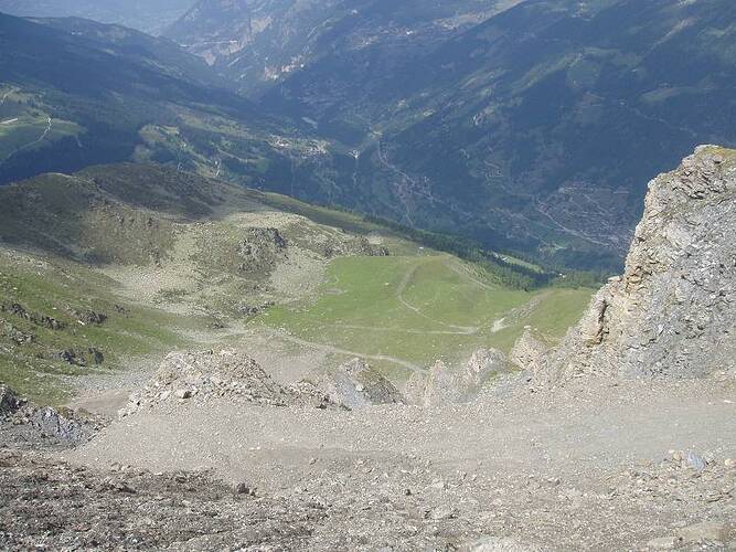
Also amusing for the euro purists that say you can’t have anything higher than sac_scale=hiking outside of the mountains or alpine. The little bypass I took the photo from didn’t get me much, but I was intrigued as I didn’t see it on the way up.

I do think there’s generally a difference in a T3-T4 proper “path” and a T3-T4 “route”, in that there’s some expectation that obstacles are probably somewhat groomed for danger even if effort and some technique must be applied.

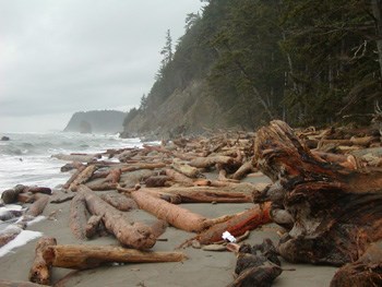
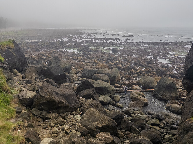
The following is in a 4 foot tidal restriction (high tides went up to 9 feet when we did it). I suppose it’d be a tidal blockfield?

1 Like

Here’s some of the issues with relying on surface and sac_scale with a route vs a path.

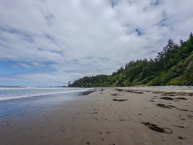
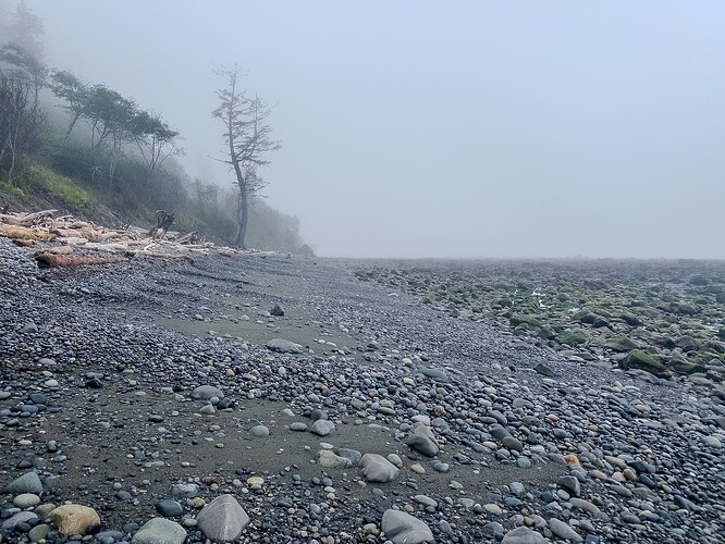
Depending on the tide the following has larger rocks and deadfall up top, then a mix of gravel, small rocks, and sand in the middle. Below is mid size rocks and shallow tide pools. surface=ground seems fair, but doesn’t really tell you much.

With a morning low tide, by mid-late afternoon the gravel is very soft and annoying to walk on, we’d sometimes drop on the rocks even though it requires more concentration to escape the slog. Coming in wet just after a low tide the gravel was much more pleasant to travel on.

Even without tidal issues restricting access, it’s something of a matter of personal preference which route you choose. We’d regularly see more surefooted people taking rocks while more novice hikers stuck to sloggy gravel.

Difficulty shifts and changes over time - NPS was warning of a section of the coast that tends to get a lot of log hazards. Given the T3 pic on the OSM Wiki is of knee high obstacles, and the T4 shows a mantle, this is possibly “alpine hiking” as presumably at some point you’re mantling one of these. I’d prefer granite for the traction myself!

norwegianmem

However it was quite different when we did it (yay)

Tides are obviously their own thing, but a lot of river routes in the Southwest shift as well. In 2021 there was a nice sandbar you could walk up to a spring on along the Paria River route. In 2023 it was finding a narrow path in opaque thigh high water. In 2024 you could basically just walk back up again, though the sandbar wasn’t quite as nice as it used to be.

That’s up to the renderer: they should show a trail_visibility=no path as clearly distinct from all other paths.

1 Like

This where the path should be a =link. These paths through an area are just an approximations. Often there just to show common ways a person might transverse the area. Depending on the surface and other factors, there may not be usable.

This is contrast with ways that have trail_visibility=no. They follow a known route that is consistent even if the segment is devoid of visible markings.

2 Likes

At odds I got reminded of waterway=flowline - or should that be waterway=river; river_visibility=no instead?

Perhaps: Highway=birdline?

2 Likes

Is a route really a path?

Sould OSM have a road that has no visible signs of being a road rendered as a clearly distinct type of road? Or something which isn’t a road?

Should a route which has no visible signs of being a path, and on which the desired route may be far away from where it is rendered as a path, be treated as a discrete path?

For a route that goes through over 20 miles of a narrow river canyon, is it feasible to map out every sandbar that comes and goes?

I can think of “routes” where large sections of them are passible, and then there is a point or two where it narrows down.

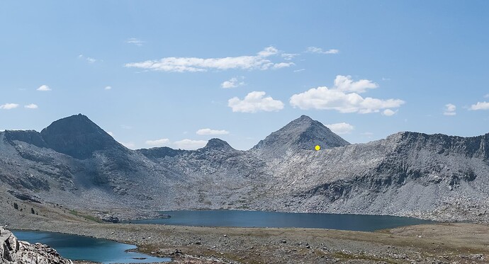
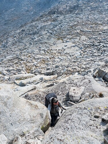
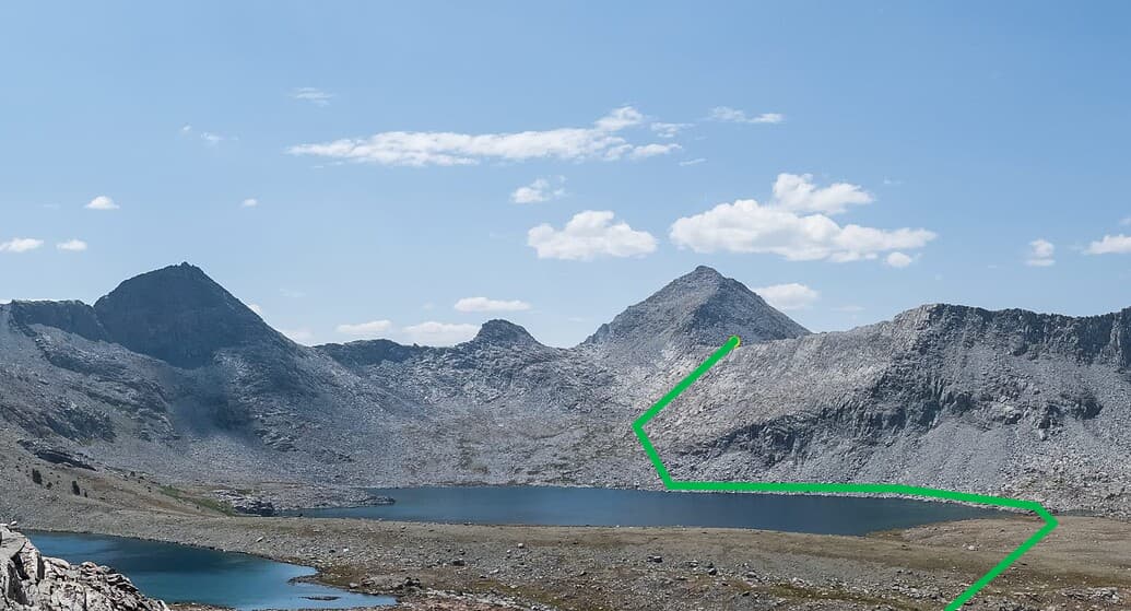
The following pass is roughly under the yellow dot. My partner and I just walked the talus to the right along the lakeshore (our camp was on the outlet side of the lake on a durable surface), then made our way up simple grassy ramps and broken granite slab to where there are two T4-5 ways to gain the ridge.

The top of the pass has two easier climbing ways to gain the ridge near each other. This is one. Note it’s all relatively simple XC below.

Up until that specific point to (relatively) easily gain the ridge, there could easily be hundreds of links that show a possible way that is sometimes useable. Someone could come from the other side of the lake, traverse high from Ramstein Pass just to the left, or drop further on a traverse over from Goddard Pass. If someone just really didn’t like talus (it was all stable down by the shoreline, we didn’t mind it) they could take the long way around the lake.

This particular pass isn’t along the Sierra High Route, or the SoSHR, or any of the Skurka ones or the new traverse one etc so it shouldn’t qualify as a route in the OSM sense. That said it’s not that unusual a use case and an obvious one that comes to mind I have photos for. :slight_smile:

See also the coastal route photo up above. Where is the precise location for proper link here? Where I was, where my partner was? She wasn’t anywhere in particular, and that log won’t be in the same spot for all that long. Just the entire area below high tide and low tide + isolated bits of passable terrain above high tide?

This is I think a useful distinction and probably one of the only useful ways to have something of any real length with trail_visibility=no.

What is the precision we are looking for here? I honestly struggle to think of a pathless route of any length where people will consistently follow a precise path.

I’m sure we’re all familiar with coming across an area where 3-4 different informally cairned routes suddenly appear (or in some cases dozens). In theory those could all be mapped, but in reality they’re arbitrary paths created by someone that’d fall under “don’t upload your personal GPX route”. I can think of say where the unmaintained (de facto if not de sure) trail peters out going up the hilgard fork of bear creek. iirc I went along the middle route, then deviated from it as I felt like doing. None of those routes, or possible links, were meaningfully different from another in terms of difficulty or safety.

Do you want to be closer to the stream, up in trees, walking across a slab? It depends on personal preference, weather, if the slab has water coming down it or not, etc etc.

So…

What makes something consistent? Over the course of kilometers of hiking, are people’s routes always within 20m of each other? 3m? 10m? 100m? 250m? At what point does it not make sense to render a line on topo because it just won’t be accurate aside from a “it’s kind of along this direction” at which point a precise line is not appropriate?
Someone was talking about land managers in the US southwest dealing with tourists that are expecting paths on routes that follow shallow river beds that require wading. Is that route surface=water? It’d be amusing to apply smoothness=* to it when there is riffling at a cascade.

People often will pop up on land now and then when it builds up along bends etc as well. Or at leatsthere is the possibility of doing so, because it is off trail and hence anyone can go wherever they want (within the confines of canyon walls). Some people might keep wading.

I would agree with the take that trail_visibility is only appropriate for terrain that people consistently travel over in ___ range of distance that would approximate the way in OSM.

That said lets look at this example on the wiki:

Does this scree field have a consistent route through it, within the margin of error that would constitute a path, with no real signs of it? There’s nothing in that terrain that indicates to me why people would be funneled in such a precise manner unless they were following a visible path.


Or is it really more of a “well the path ends down there, and people aim for this pass at the top, so we’re going to make up a path in between so people can route it but in reality if you actually tried to follow it precisely you’d probably just be worse off”?

I do find it amusing that since its conception, the trail_visibility page has used the term pathless. bad in 2010 acknowledges the difference between a path and route:
“Path sometimes invisible, route partly pathless”

Does path=pathless make sense? path=not_a_path?

Even at bad, it’s a mix of highway=path and highway=not_a_path. And that is the fourth best value out of six. Using trail_visibility=no to do an entire long way of a route MORE of it is highway=not_a_path than highway=path, and horrible is getting close to that. It’s worth pointing out that given the keys SAC origins that most countries in the world do not map horrible or no visibility routes on their formal maps.

There are only two or three trail_visibility key values that actually deal solely with physical trails (depending on how you interpret intermediate). It makes sense from a laziness standpoint - if a path has some gaps in it but mostly exists it can be tedious to map all the minor breaks in it. If they’re short enough it probably isn’t worth it.

For larger breaks (like the 50m one for the good visibility example), it could take someone longer to look for a path that they think should be there then just routefinding to the next spot where it exists. If orienteering is a requirement, then that seems fair to assume someone knows how to fill in the blanks. A link in this case would probably make sense.

In the US “trail” refers to the physical path that is either constructed or though informal usage has enough signs of passage to be followable similar to a constructed one. Jeep/OHV people also refer to 4x4 roads as “jeep trails” which is probably an evolution of a stock or horse trail vs foot trail.

If there is no trail, but someone is hiking over terrain, they are considered to be “off-trail”. If they were on a known route, but there was no visible signs of any trail, they would still be considered “off-trail” or “cross-country (XC)”. Someone hiking off-trail is often said to be using routefinding (orienteering) and is often just moving from known point A to goal B… and that pathless gap is part of the experience.

A lot of routes purposefully do not try to draw a line for people to follow:

a) If someone needs to stare at a line on a map, they might be in over their head and require rescue later. Given that there is NO VISIBLE PATH TO FOLLOW, even being with the margin of error with GPS can have consequences if you can’t read terrain.

b) In areas where there is no path, an abritrary one can lead to condensed impact and one appearing.

c) if people wanted to hike on a trail they could just hike on a trail. :stuck_out_tongue:

What we’re essentially mapping here is trail=not_a_trail. It simplifies things at least.

Using the corresponding image as a guide, there would be a number of natural paths through the scree field. It is all based on the where are you going and how would you get there.

Transver lines only purpose it to be an approximation of the most likely pathway across an open area. It should favor a crossing at the midpoint. Only deviating when there is something in the way.

I would map this with a highway=path with trail_visibility=no with as few nodes as possible to avoid areas where it’s hard to pass (here the water of the lake and what seem to be cliffs above the scree area), like this:

I assume that someone reasonably able to read a map will understand from the dashing of the line on the map, the area being mapped as scree and the long straight sections, that there is no actual path visible and that one is not supposed to exactly follow the straight lines but is expected to find your own route based on the local situation. It will tell you approximately where to stop following the lake shore and start ascending to the pass so you will avoid the cliffs, which is useful information. That is assuming this is part of an official route published by a reputable authority.

1 Like

@erutan have you seen (non osm based) maps that show official pathless routes with a distinct cartographic style from trails/paths? I’ve been looking for examples but coming up short. It seems to me that regardless of the underlying OSM tags, it would be best if maps consistently showed pathless routes with a distinct style that would not be confused with an actual trail.

2 Likes

What about ‘Tag:informal=yes’?
It wouldn’t be perfect, but I think we could use a tag like this to be a bit of a blur, rather than trying to separate purposes too finely.
In my case, I often use it to link outside of a pedestrian area to outside of another pedestrian area.

From memory, at least information boards for the Bibbulman Track in WA use dashes for “make you own way from A to B”. The online version just seems to be a G**gle map, so no point in looking there.

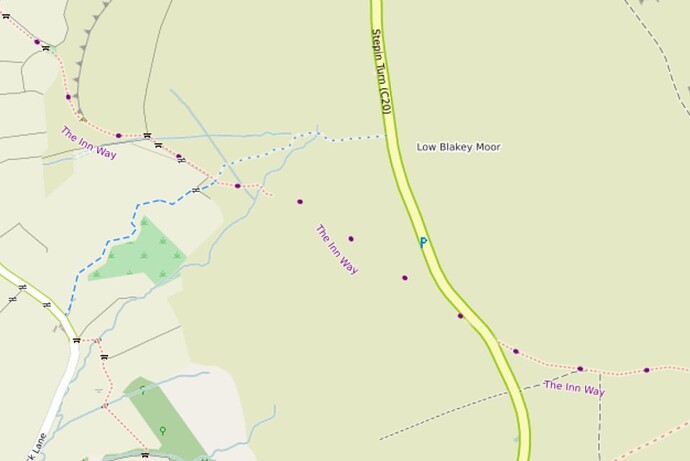
For an OSM rendition of a “pathless route” see here (disclaimer - one of mine).

1 Like

Thank you, this is a good example of how a pathless route could displayed in a distinct style. The tightly spaced red dotted line shows sections with a path/trail while the widely spaced larger purple dots suggest a general route where there is no path.

In this case, the pathless way has no other tags besides a note, but it is a member of a route relation. This seems a reasonable mapping style to me, but there is also no reason renderers couldn’t use a similar style for ways tagged differently. For example we could say that anything tagged highway=path + trail_visibilty=no should be rendered in a similar pathless style. To me that combo feels rather like a trolltag (here is a path that is not a path), but I know highway=path is widely used today for these pathless routes. I’d rather get rendering improved downstream than argue about which tag to use.

4 Likes

This tag is a bit different. It is for actual physical paths that are not formally maintained or designated by land managers. Here we are discussing routes that are formally designated by land managers but have no physical path.

It sounds like Tag:footway=link - OpenStreetMap Wiki might be appropriate for that sort of thing.

4 Likes

Sorry, I think I mis-linked something.
It’s the tag ‘Tag:informal=yes’, not ‘Key:informal’.
I understand that ‘Tag:informal=yes’ can be used on any road (tag:highway) and is not a fixed route, but can be used on any actual route.
For example, I understand that it can be used in places where people can pass by anywhere, like a playground, but a specific routing route is needed.

You’d be surprised. There’s been multiple SAR incidents from people following a literal two node way into technical terrain on a climbing descent route from the north rim to Yosemite Valley.

There’s already many layers of stippling that can get applied based on difficulty, visibility, formality, etc that a slightly lighter dashed line can be confusing. This is deep in the backcountry, but there are froncountry accessible routes where people see a line and dashed or not assume it’s a path.

I’d agree with this general approach, but would take out the lines connecting the nodes that you drew. It’s somewhat arbitrary where someone decides to go up from the lakeshore - someone might want to wait a little longer to have a mellower approach etc. The cliffs are easily visible and won’t surprise anyone. There isn’t any scree on this route, just talus, slab, and grass.

I’ve been on a few “routes” that consist of a few nodes and have lines going over 100ft dryfalls etc. It’s just a bad look.

The pass itself is written up by a reputable authority (Secor), but he didn’t bother to describe the route since it’s pretty self-evident aside from telling people to stick to the north shore of the lake on the far side due to cliffs & talus. He’s arguably a little too terse at times, though I think that also makes things more interesting. I’m not sure if it’s included in any formally published guidebooks, but there’s definitely many that I haven’t read.


Off topic-ish rant on the recent proliferation of XC routes.

Reputable authorities gets vague for routes IMO. This book is a mashup of existing published XC routes and forum posts from High Sierra Topix made by a guy from Australia that as of 2015 had to use someone else’s guide to get around. He probably used some of my pass write ups online to monetize this poorly named route (part of it’s marketing pitch is that it traverses the range less than the one that inspired it). It’s a sensible route but anyone can publish a route these days. AFAIK I’ve done everything in it non-contiguously, and have had someone use my beta on a pass in it to tell someone else they were off-route because conditions had changed (which I wasn’t happy about and told em off for).

IMO putting up routes for this, the SoSHR, Skurka’s recent routes, Ropers SHR (which he would be very against - he even struggled with writing it up and publicly sharing it), on OSM would go against the norms for the region. But that’s perhaps more of an old school US alpinism thing.

It seems like people creating routes are semi-inexperienced hikers that find existing acronym route guides useful, do some internet research, and then make their own either to be helpful and contribute back to the community, for vanity, or because they’re convinced they’re very clever. Kim Stanley Robinson has an epic rant on this in his book High Sierra: A Love Story on this trend. I’ve definitely seem people be too prescriptive when writing up passes (there’s usually spots where you can do what you want, then some where you shouldn’t - just because someone did something X way doesn’t mean that’s the route) where there’s a lot of wiggle room, and people can spend WAAAY too much time trying to min-max a 1% better route up something that’s perfectly fine either way.

I personally get annoyed when people try to just copy a route I did (I’ll report back on conditions) because they’re a family arbitrary mix of things I want to go again and places I haven’t been yet. I’ve corrected some mis-published passes online, and written up ones with zero internet (or afaik written) presence like Ursula & Vernon, misunderstood ones like Cirque & Mosquito, and then some that are grossly under-covered in any meaningful manner like Dragon. IMO most subject experts on the range don’t make routes because you can string together any number of passes and have a great trip. :slight_smile: I feel it’s better to create resources for people to safely be able to do that vs just giving them an arbitrary route to follow.

Amusingly my riskiest incident wasn’t me just looking at topo and then figuring it out, but on an alternate option of a known popular route (the SoSHR), where I had to spin sideways to avoid a 5 foot piece of talus that started coming down when the talus I was coming up started collapsing. Ended up with just two scars on my arm, scrapes on my leg, and a lot of adrenaline. There can be a false sense of security from something being “on-route”.

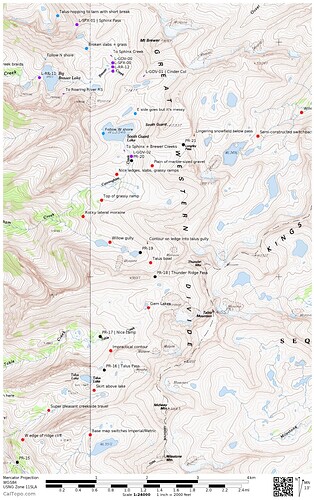
If you count Skurka then this sample image from his Kings Canyon route works and is similar to the one above. Amusingly he hadn’t actually done every part of the route when he went to sell it for $25, and was also cobbling together info from an a non-reputably published resource. He is self-published, but overall is a more reputable/experienced source than some and is more well known. A lot of thru-hiker types move on from trailed thru-hikes to his XC stuff because it eases them into being off-trail (including the guy that came up with a recent route).

The sets of waypoints is the way I see routes done most often. The other way is just a hand-drawn wide translucent line to indicate ambiguity.

Some of the notes here are meant to compliment his written description, so it’s not a perfect example (improbable contour etc).

One issue with automating this is that you could have a LOT of nodes to the point where it is almost a line. If you just strip them down or have them set to have a minimum distance you can have misleading ones (say they miss a big switch or something so it looks like you go up between them vs around).

I suppose just having this happen and then prune them down is the easiest solution.

Honestly trail_visibility=horrible should probably get the same treatment. If people want to clean it up later they can have the actual bits of path rendered as paths with the large chunks in between as trail_visibility=no. I’m not sure what “often” parses out to be, but I’m guessing it’s be around a third to a half pathless which is significant enough that people shouldn’t expect there to be a path to follow. I do see a lot of informal alpine paths as isolated non-connected paths which makes perfect sense to me - here is some ground truth, it’s up to you to get there. It might be worth having some key XC points to attach them to the pathless points of a route, but not in all cases.

That’s a good point. :slight_smile:

One thing that would be useful is to be able to have short descriptions/labels on the nodes. Cirque Pass has been written up by Secor, Roper, etc and then in more modern guides that I haven’t bothered to buy and has one critical point on the south side where just past a pond there’s a grassy ramp that leads you into Class 4 vs a unassuming usually dry drainage that keeps you on Class 2. I swear like 2/3 of the people I’ve talked to going down that pass have ended up on the slimy micro cliffs. :confused:

Making a route node more of a discrete object with properties vs just a dot is obviously not ground truthy, but honestly neither are a lot of XC “passes”. Little Joe in SEKI just the top of one of many avalanche chutes and is closer to being a high point on the ridge than a natural saddle etc. Being able to label the bottom of the chute, and then perhaps two of the main branches inside it (I know someone that took a wrong turn and had to bail). Keep East, Keep West, Wrap Around Cliff Band, Traverse Below the Buttress, etc would fit into existing written beta and provide some context for the gaps without being too handholdy or giving a false impression of pathiness.

There’s some routes where one side is very trivial until you get near the ridge - the east side of Dragon is straightforward Class 2 keeping near a drainage that ends turning into nice informal switchbacks before you hit the headwall where the peak is climber right and the pass left. From there options aren’t great and choices matter, but up that point it’s pretty simple. Just have a node leaving the lake below (which is heavily cairned IRL anyways), then the actual informal path to the headwall, then a note on where to go up after traversing would work well and where to gain the ridge. The drop point is a little further north, so it’d need to be marked as well (writing as from E to W).

I think being able to relate nodes to a path as all part of a route is useful and should get rid of some of the lazier trail_visibility=horrible stuff.

trail_visibility= still a terrible key IMO, both in it’s naming (isn’t scoped to trails) as well as values. If you asked the average hiker to look at actual trails and describe the visibility I’m sure some of the “excellent” ones in OSM would 9/10 just be called good or okay (excellence has a very low bar) and the “good” example of a 50m gap where there is no sign of a path at all, or a faint but followable path through crushed grass would be called poor or intermediate. But it is what it is.

There definitely can be too few nodes, like the literally two node way that led into technical climbing and hence multiple SAR incidents above Yosemite Valley. Ideally there’s few enough that people still need to be alert when routefinding, but not so few that there’s too much ambiguity when there is a precise route necessary.

PS - still getting over covid so this might be a bit rambly, brain is still a bit foggy.

Informal just means that isn’t formally maintained, it’s not related to something being a path or route… There’s plenty of informal trails that have good visibility because terrain funnels people into a set path and the ground holds use well.

Link (discussed above) would be more appropriate for this use case.

1 Like

These illusionary lines are mainly designed to allow routers plan and connect established routes or trails that are currently seperated by areas. They should drawn in way that follows the path most likely taken by someone familiar with the area. One would hope that it relatively safe as it tries to avoid
of the obvious hazards.Even if it is, these lines are meant to suggested routes.

As in the previous scree coved slope, there would multiple lines. Each line going a different direction. Likely following the elevation change required to cross the area in a particular. It is still up to hiker how to cross since thee is no established trail to follow.

Actual hazards should mapped individually so travelers are aware of them. It is also up to the individuals to determine whether they ready for the environment based on tags attached to area.