Well, we map what’s on the ground. I’m not aware of any signage saying “Gulf of America” but perhaps we could send any complaining Trumpsters out to the node location to survey it?
3 Likes
I can envisage Musk advising (and funding) Trump to create OpenTruthMap, to make America great again, which doesn’t need any ground truth.
6 Likes
Ze Germans have chimed in saying: “It will be ze Golf von Mexiko, ja.”
6 Likes
Looking in from outside, OSM as a worldwide map really should not be cancelling countries or governments, although we might need to respond if a campaign of map vandalism or similar hostility is found to be the work of a government. I would allow the local community slightly more flexibility.
If you mean Chevron, they have started referring to “Gulf of America” in their financial statements. They if anyone would know what’s “on the ground” far beneath their offshore drilling rigs. However, I don’t expect Pemex to follow suit; for sure they aren’t contemplating a rebranding to “Pemerica”. ![]()
5 Likes
1 Like
Perhaps “Gulf of Texaco” would be more accurate?
I wonder how much those two companies would be willing to pay to sponsor an OSM listing.
4 Likes
Perhaps instead of changing the name only in English, we should add it as an alt_name, or even remap like the president of Mexico is proposing to Google, the 22 nautical miles in control of the US will be Gulf of America, while the rest, under Cuba and Mexico control, will still be called Gulf of Mexico.
And adding to my two cents, I think it’s much more fair to add the new names adopted by Trump as alt_name, because perhaps in 4 years the next president may revoke the orders that renamed Mount Denali and Gulf of Mexico.
EDIT: I just read the wiki page and I think official_name is the way to go, as the renderers don’t use it, opting instead for name.
1 Like
Would you believe it?!?
This tiny part of the worlds oceans has seen19 changests within the first 16 years of OSM - within the last 31 days there were another 81 dealing with it. Plus a topic with 290 posts spinning around and around. What a waste of time.
With nothing but a signature under a piece of paper the initiators created a storm in the waterglass - some kind of chaos - and exactly that is their motivation and intention, I believe.
14 Likes
This is, in effect, what happened with GNIS and The National Map already.
1 Like
The Executive order mentions the USA continental shelf, and a surface of 160 million acres, meaning it only applies to the continental shelf. The Mexican Gulf is 365 million acres…
3 Likes
you mean 1.477 million square kilometers, right? ![]()
4 Likes
Saw it 3-4 days ago on a political website, but now USA Today also carries the news how MapQuest has opened a page where everyone can enter their own name creation and print it full colour or distribute, insisting they stick to GoM and adding on Xitter they would not even know how to, over 15 years ago they made the last change thus a long forgotten skill.![]()
Given them directly calling the HERE map API, I doubt that MapQuest would be the one in charge. Their sub-page is great though:
7 Likes
I just want to note how hypocritical it is that the US is making any Extended Continental Shelf claims when they have refused to be party to the international agreement (UNCLOS III) that defines what the ECS is and the process by which claims are made and disputes resolved. As a Canadian, it is just so… "<sigh>, here they go again".
5 Likes
You are wrong in what this says. It says all of it is now named “Gulf of America” extends “to the seaward boundary with Mexico and Cuba in the area formerly named as the Gulf of Mexico”.
In other words the entire Gulf except for the 62km section of coastline next to Mexico and Cuba.
No, and the reason why is that word ‘seaward’. ‘Seaward’ means ‘away from land’ (‘landward’ means ‘towards land’) so ‘seaward boundary’ means the boundary at the furthest points out to sea - for all three countries. This is what the de jure (Mexico and US, Mexico and Cuba) and de facto (US and Cuba) split of the Gulf of Mexico is:
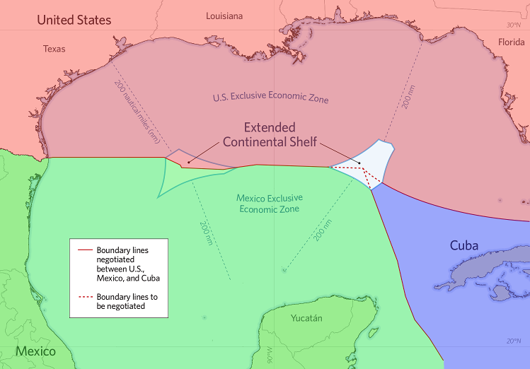
The boundary between Mexico and the US, including the division of the western Extended Continental Shelf, has been agreed to by treaty. The eastern ECS is still unresolved and will likely remain that way until US/Cuba relations are normalized (don’t hold your breath). Even the non-ECS boundary between the US and Cuba is not formalized - every few years the US and Cuba exchange diplomatic notes in Switzerland agreeing to disagree but respect the status quo.
(Edit: apologies to those who are colour blind, I spent so much time getting the boundaries selected correctly that I put zero thought into the colours: so RGB it was.)
7 Likes
That would be tag “name:es-US” ? (the “es” is not a typo)
1 Like
It would be, yes. As far as I know, common usage hasn’t changed among U.S. Spanish speakers, so there’s no need to override name:es=* with anything regional.
4 Likes