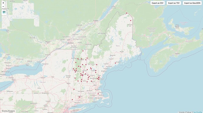
A prerequisite for classifying the place=* points in New England is making sure that they actually represent what they purport to represent. The place=* values more or less fall into three orthogonal hierarchies:
| Administrative areas | Population centers | Parts of population centers |
|---|---|---|
countrystatecountymunicipality |
citytownvillagehamlet |
boroughsuburbquarterneighbourhood |
The vast majority of place=city/town/village/hamlet nodes were imported from the Populated Place class in GNIS. The coordinates are located at a “downtown” rather than the centroid of any administrative area, and the Feature ID in gnis:feature_id=* specifically represents a population center. (The Civil class in GNIS represents administrative areas, but we never imported those features.) To the extent that these population centers correspond well to TIGER-imported administrative areas in name and function, they are label members of administrative boundary relations.
If you were to map a place point for an administrative area, it would be located at the area’s centroid, regardless of where people live or work, and it would be the label member of an administrative boundary relation. Most states and counties have such place points. This is also an option for the cities and towns that evenly partition New England counties, which would be tagged as place=municipality, but to date only two have been mapped as points: Clarksburg, Massachusetts, and Colchester, Vermont. (place=municipality is the standard tagging for towns in New York and Wisconsin.)
Unfortunately, the TIGER import sometimes incorrectly conflated some places with larger, identically named places elsewhere in the state, inflating both the population and place classification. Compounding the problem, subsequent mass edits conflated many more populated place points with administrative areas by the same name, even though only a small portion of the administrative area is built up.
In the Midwest, many sleepy unincorporated communities wound up with population=*, wikipedia=*, and wikidata=* tags corresponding to the entire surrounding township, even though the point remained at a tiny population center in one corner of the township. Even today, in New England, this QLever query finds 413 place=city/town/village/hamlet/neighbourhood points that are linked to cities or towns in Wikidata and generally have the populations of those entire cities or towns, as if the feature were really tagged place=municipality. These points should ideally match CDPs that the Census Bureau has created to approximate the town’s central village.
In some cases, this overconflation may be the best we can do. In Maine, the Census Bureau abolishes any CDPs within a town when it reorganizes as a city, even if nothing has changed about the city’s population distribution. But ignoring that problem, this QLever query still found 48 place=town/village/hamlet/neighbourhood points that were linked to towns in Wikidata despite there being a CDP by the same name within the town.
I’ve gone through these results, replacing each point’s population=*, wikidata=*, and wikipedia=* tags with those of the CDP; changing its role in any administrative boundary relation to admin_centre; and adding it to a boundary=census relation, if available, as a label member. In some cases, the population rose as I simply updated the figure from 2006 estimates to 2020 figures, but in most cases, the population fell – in some cases, to as little as two percent of the previous figure.
I haven’t changed any place=* classifications, so some of them stick out more when you compare their population figures to a global distribution of place classifications. For example, at 17,000 residents, Brunswick, Maine, would be a median town globally but is tagged as a city. Hillsboro, New Hampshire, with a population of 2,200, is tagged as a town but is about one standard deviation away from both town and village. The 23 residents of Bolton, Vermont, can hardly claim to be a hamlet, let alone a village as currently tagged.
With these more accurate population figures, we have a more sound basis for evaluating the current classifications and any replacement criteria.

