Hei Norske OSM samfunn. I TomToms prosess for å forbedre OSM, planlegger vi å utføre redigeringer basert på detaljert bruker input. Denne aktiviteten er basert på å sjekke om tilbakemeldinger knyttet mot TomToms kart også er gyldig for OSM kartet.
Vennligst vær oppmerksom på at det i begynnelsen kun er et mindre antall lokasjoner og vi vil bare gjøre endringer dersom; De medfører verdi til OSM Kartet, ikke er i konflikt med nylige redigeringer gjort av OSM samfunnet og at endringene er støttet via lokale datakilder. I mangel av troverdig kildemateriale, vil vi henvende oss til det lokale OSM samfunnet for veiledning.
I løpet av denn aktiviteten vil vi starte med interessepunkt, arealbruk, adresser og veier. Over tid vil vi evaluere flere typer tilbakemeldinger og utvide tematikken.
Vennligst se Norway GitHub for ytterligere detaljer om typen planlagte redigeringer. MapRoulette-utfordringen som brukes for disse redigeringene vil kun være tilgjengelig for vårt redigeringsteam, da den kan inneholde konfidensiell informasjon.
I tillegg til #tomtom-hashtaggen som følger med hver TomTom-redigering i OSM, vil vi også legge til #tt_mapfeedback til endringssettet dersom redigeringen utført er basert på bruker input. Vi planlegger å starte med Norge om 2 uker sammen med et utvalg av andre land hvor det finnes bruker input og deretter utvide med ytterligere land ovder tid. Ta gjerne direkte kontakt med meg hvis du har noen tanker eller spørsmål om denne kommende aktiviteten.
Thanks for giving us a heads up. You mention “arealbruk” (I’m assuming this might refer to landuse/landcover) is something you will start editing. I’m particularly interested in this topic. I can’t find any mention of plans for landuse/landcover on the github page you link to. Could you perhaps give some details as to what your plans are for this topic?
Sorry about that. I obviously didn’t read carefully enough. Thank you for patiently pointing me to the right place.
But, continuing on the topic, now that I think I understand the plan with regards to land use. I have some feedback and questions, mainly regarding how we ensure high quality of the edits that will be made.
Particularly with regards to landuse/landcover the Norwegian OSM community has access to some powerful resources:
The Norway Orthophoto image layer - high res aerial photography with minimal offset
The N50 topo layer - detailed topographic map data, including info on landuse
I don’t know the details of how TomTom’s user feedback for landcover is generated, but if the user providing feedback isn’t able to leverage similarly powerful data in the process in which they provide said feedback, there is a high risk that the feedback they provide could end up being of noticeably lower quality than existing OSM data. For instance, if they rely on aerial imagery with large offset when proposing a change, that offset can propagate into OSM unless corrected for.
This puts some responsibility on TomTom to correct for such issues as part of the process of propagating such changes to OSM. I hope this is part of what you imply by “comparing and ensuring that [the feedback] is also valid for OSM”.
Also, for some municipalities in Norway, there is little to no landcover at the moment. For these municipalities you might actually get more bang for your buck by waiting for the topography import to be done, or contributing to its completion, rather than allowing small additions from users. Doing the latter before the import is done might actually complicate the import work. I also expect the quality of the feedback you get to go up if what is being given feedback on is already of high quality (e.g. imported topo data).
Don’t give this latter point too much weight, though. Nobody stops OSM users from adding small bits of landcover to these municipalities today, pre import, even though it might complicate later work. So we can’t really deny it to your users either, IMO. I’m putting this out there mostly so that you have an opportunity to consider where to put in your effort.
Indeed you raised the right signal points.
In all of our activities, we must comply with country-specific, resource usage guidelines per feature. Tomtom will do its utmost to ensure full visuals and due diligence are completed on all available datasets and sources, but as stated earlier, we will always contact the community for confirmation when necessary. We’re checking the country specific wiki pages for source material as part of our standard practices. If there are sources not documented there that we should be aware of, please let us know.
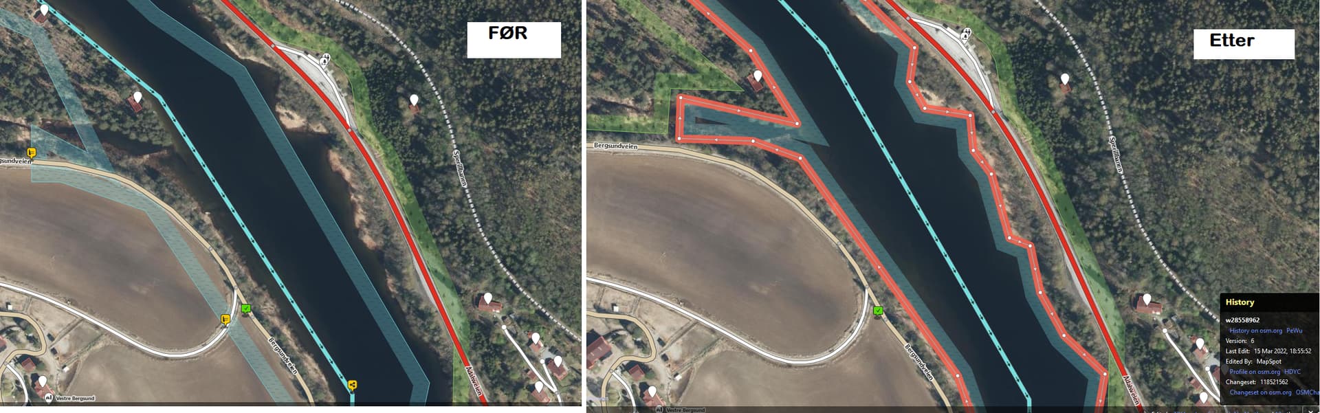
Is this (bad) data from previous N50 topo dataset imports (or found a source: “Corine Land Cover”), or will it be improved by the import? Just curious and please recommend work going forward: Should non-expert OSM editors stop changing landcover usage?
This edit is in one of the areas where the N50 import has yet to be done. It is likely to take a long time for the import to happen in the relevant municipality, if ever. The reason is that there’s already so much data in place that would overlap with the import, meaning an import would be painful and error-prone.
As such it should be considered a good thing that you are updating and improving the landcover that is already there. So go ahead, and feel proud in the work you’re doing.
To be clear, the municipalities I’m referring to are one’s like Tana or Senja where there’s very little pre-existing landcover. These are prime targets for import and I would advice anyone interested in landcover for these municipalities to prioritize the N50 import over other measures. Once the N50 data is in for these areas we have a strong foundation that can be further refined by individual edits.