No, as “bathing place” should also include the part where you actually bathe/swim.
That also sounds to me like a clear cut case where one would map it as a way coincident with the coastline, unless there is a more or less clear-cut “entrance” to the beach (like one car park with one main path through the dunes or something) in which case it could still make sense to map it as a node for navigation (as one would always pass close to the node, regardless of the current location of the swimming zone.
This is also an interesting case that should be noted on a revised wiki when leisure=swimming_area should not be used, despite there being verifiable flags, since they change regularly.
I don’t want to put a number on it and barely even another measure, but in my mind one might want to use a way rather than a node when the the width of the shore is more than maybe 150-250m.
Also thank you for everyones input so far, this is exactly the kind of discussion I wanted so that we can get a description of these features that fits internationally!
We have a lot of informal bathing areas across lakes, rivers and beaches. On the odd occasion, there may be facilities and signage but lots of cases where there is neither.
Beaches are probably the most popular location (especially when the weather is warm during the summer). Popular beaches will have lifeguards on duty - the previous discussion around this aligns with practices in Ireland. While swimming parallel to the shore is common, a lot of people entering the water are more likely to be paddling or standing and jumping as the waves come in. Marked areas and lanes are rare at beaches (but do exist in some places where there may be boat activity).
In relation to lakes (and a lesser extent rivers), marked areas / specific facilities for swimming are again rare. What I do see a lot of is people training for triathlons and other endurance events - I believe “open water swimming” is the turn used for this. These are people swimming 1+ km along a lake / river without any particular navigation aids. In relation to families, we do have spots on lakes and rivers where bathing would occur (I wouldn’t call it swimming per se).
In relation to terminology:
“public baths” would be very rarely used here. Swimming pool would be used in most cases. We do have a few outdoor swimming pools. Some are pools that are only used during particular seasons (summer). There are attempts to build a number of lidos in the country but they may just end up being white elephants (our weather isn’t that good). We also have a handful of pools that are located on the coast and filled by sea water (sole commercial, most are not).
“batheing_place” would not be in use normally here but would be understood by most. I think people would lean towards assuming it was a natural location without markers in the water / formal structure.
swimming_area: I’m sure we have some examples of this but the discussion to date indicates this is a more formal setup with the potential for marked lanes, etc.
I do think it’s helpful to map these so it’s easier for data consumers to find such locations. I also concur that hazard tags will be useful for flagging locations with known rip currents, other dangers.
As an American the bath/e divide doesn’t exist. We make no distinction between the two concepts or spellings. Bathing has always been related to self cleaning or soaking in a small body of water. That water can be in a tub or outside. It has never been connected to any type active swimming.
This makes bathing_place and swimming tags redundant. Unless a body of water is too small or shallow for active swimming it is just considered a swimming area. Man made swimming areas are simply swimming pools.
I can think of at least one example on a long beach where in theory you could swim anywhere but people tend to go where the car parks are, and locals would say (in English) “let’s meet at [place X]”, not “let’s meet at [beach X]”. The beach is too long, you would never find each other. The locations of these named places don’t change. This strikes me as a good example of where multiple leisure=bathing_place nodes could be mapped along a single, longer beach.
As the Australian example shows, at the end of the day it always has to be up to the local community and what makes the most sense given local conditions.
@Mammi71 I wonder what you make of this map? As you can see, the regional government has actually subdivided the long beach from your example into seven distinct bathing spots (“Badestellen”), with descriptions of each of them and data on which kind of facilities they have. Not sure if these are signposted.
I’ve never seen marked lanes in the sea but I have seen areas for swimming that are marked by a rope, buoys or some other barrier. Here is an example, this is what I understand leisure=swimming_area to be:
I haven’t seen this in the UK either but in tourist resorts in the Mediterranean, and in lakes elsewhere. Swimming outside the marked area is often forbidden or discouraged as there may be algae, jet skiers or other hazards.
I don’t think that’s the same as an open-air seawater swimming pool, which would probably be tagged something like leisure=swimming_pool location=outdoor covered=no tidal=yes/no:
Setting up area with divided lane is common on lakes. It is usually away from a beach or general swimming area. I have seen at least two versions. One version is where a rectangular frame is created by a collection of piers. The lanes ropes are then strung between piers. The other use the existing ropes used to divide the swimming areas as attachment points.
In either case, I would consider the area created by the swim lanes, marker ropes. This is a close as we get to a pitch. As a result I would tag the area as sport=swimming. Any immediately surrounding piers used by swimmers during competition could be considered a its own swimming facility.
With the definitions proposed by @02JanDahl we would get:
for the area with divided lanes for doing lengths, an area with leisure=swimming_area sport=swimming
for the separate “general swimming area” by the beach that is used by families to go in the water for a short while, play with inflatable toys, … a node with leisure=bathing_place (unless, if that area is also clearly marked by ropes, then it would also be a swimming_area but without sport=swimming as people who want to exercise would likely use the separate facility)
Of course, the bathing spots are signposted. There it is called “Übergang” (crossing) or “Strandzugang” (beach access).
This begins in the very east with crossing 1 (called “Sundische Wiese” on the map of the Mecklenburg-Western Pomerania state government). From here on to the east, bathing is prohibited; this is where the core zone (absolute protection zone) of the national park begins. Unfortunately I don’t have a recent photo here, Mapillary still shows the old signs.
Further westwards, the “next” bathing place on the map of the state government called “Müggenburg” is already Crossing 5.
The “next” bathing place “Kurhaus Zingst” is crossing 22, the main crossing of the Municipality of Zingst with a pier.
The seventh crossing, called “Prerow Regenbogencamp”, is already number 49!
And then, in the area of the campsite along the beach, there are countless more crossings, probably no longer counted.
The state government cannot measure the water quality at all bathing spots here. It doesn’t make sense here either, because due to the sea current along the coast, conditions are almost equally good everywhere. That is why the measurements are only taken at selected bathing spots.
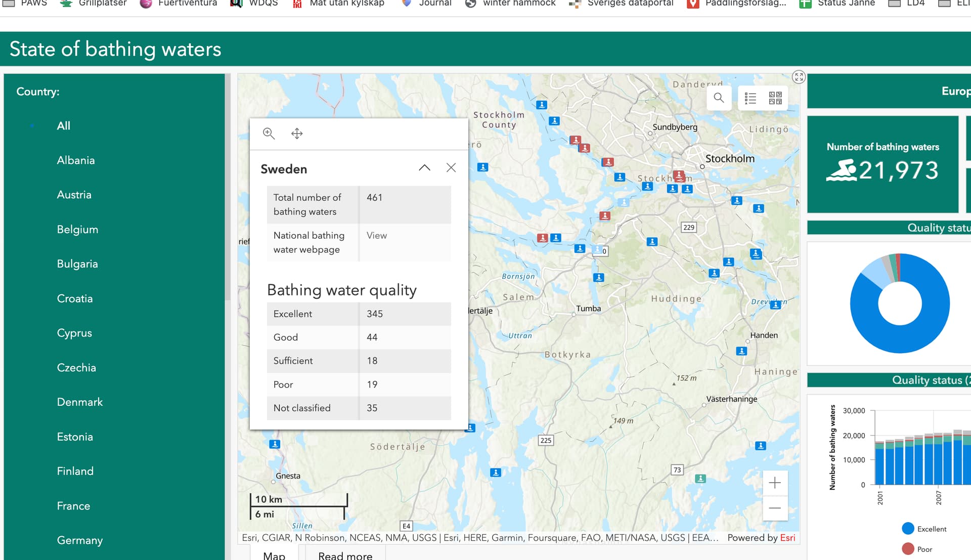
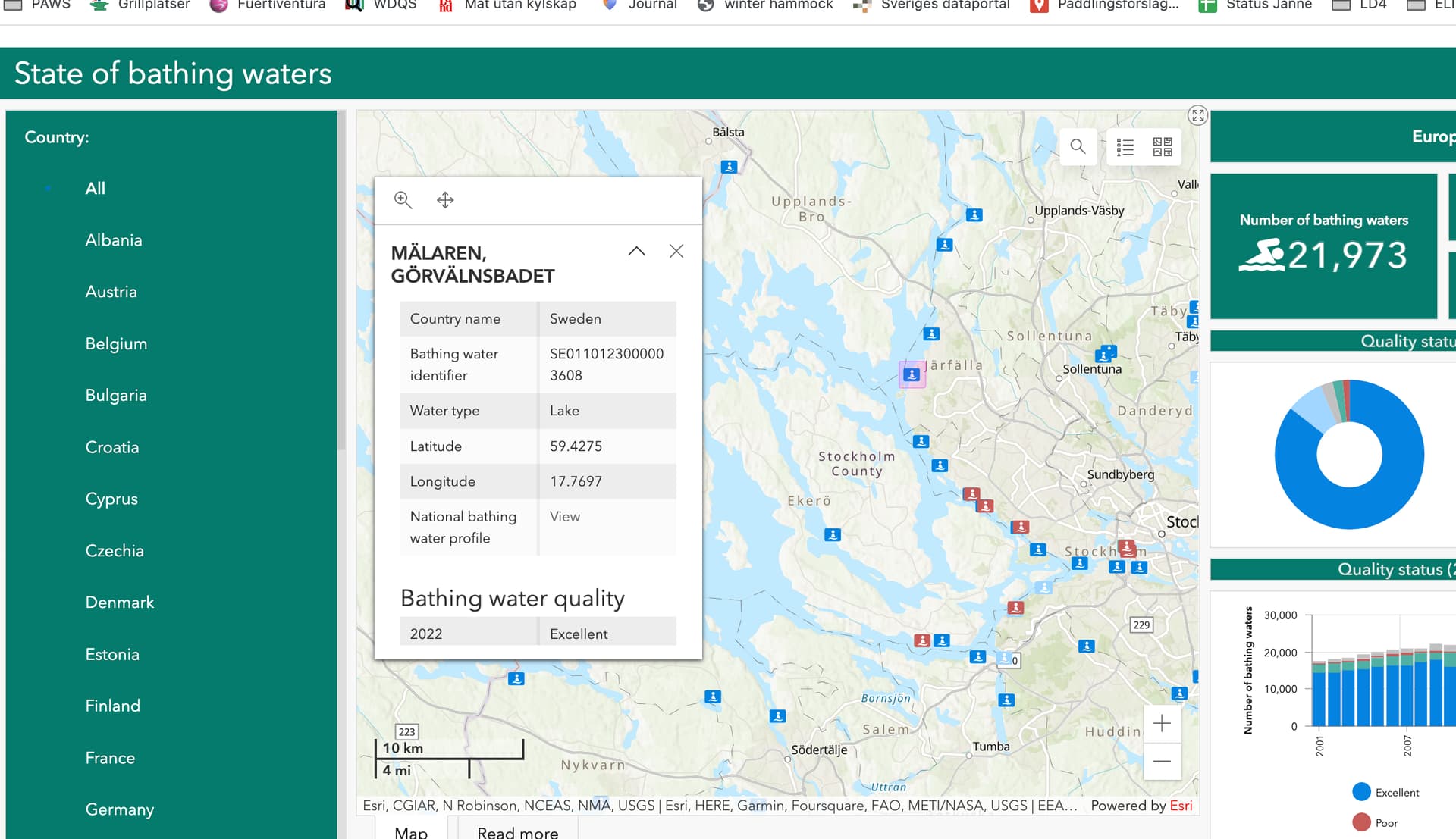
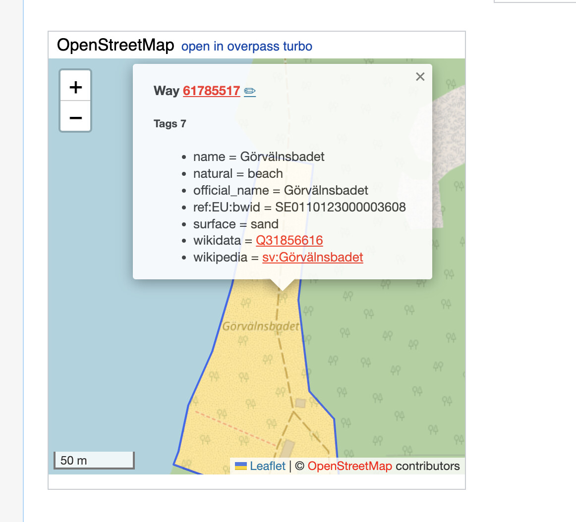
Thanks! It would be great if we could get more of these identifiers into OSM (ref:EU:bwid and/or link to the Wikidata entity with the wikidata key). This could pave the way for future OSM-based apps to show things like water quality directly in the app. The leisure=bathing_place tag seems like a natural fit.
Will do the “Swimming and bathing” page next, as well as probably do some minor adjustments to the tag pages in case I find anything that can be improved.
While I find the tone a bit too prescriptive for my taste (especially on the swimming_area page) I think overall your edits reflect the discussion well.
I have a few additional suggestions.
For bathing_place: I do not find the second paragraph helpful, to be honest: I think it introduces more confusion instead of clarifying. It’s also debatable whether it’s even true (we could probably argue for hours about whether someone goes to the beach because there is a beach, or because they want to swim in the sea). Could we delete it, or, if we must have it, move it to the bottom of the page please?
For swimming_area: the description at the top sounds rather vague to me (“an officially designated place where you can swim in a body of natural water such as a reservoir, river, lake, or the sea … It could be marked” - emphasis mine). “Officially designated” doesn’t automatically mean it’s marked or even signposted. This still makes it hard to distinguish between a bathing place and a swimming area. It’s only further down on the page that it becomes clear that a swimming area is always marked by a rope, buoys or some other barrier. Can we make that clear at the top please?
I also noticed you didn’t touch the descriptions in the info boxes. I find that they do not sound so self-explanatory or idiomatic in English. May I suggest
bathing place: from “a location where the public may bathe in common” to “an outdoor location without significant facilities that is commonly used for bathing; a wild swimming spot” - with a strong verifiability warning near the top of the page (e.g. signposted, regularly used and locally well-known, and/or officially designated)
public bath: from “A location where the public may bathe in common” to “a facility for communal bathing that is open to the public”
swimming area: from “An official open-space natural place where you can swim” to “an area for swimming within a larger body of water (such as a river, lake or the sea) that is marked by a rope, buoys or similar”
That is a much better description but is still defing a bathe in term a bath. When, as a non-British speaker, have never heard of of the term “bathe”. Is it similar to “bathing in a tub”?
I’ve noticed another inconsistency. The swimming area page says to always add a bathing place too, but a swimming area might exist at managed leisure=beach_resort. A beach resort has a lot of facilities, so it would be wrong to add a bathing_place there, correct?
So maybe the swimming area page should say that swimming areas often exist near bathing places, beach resorts and public baths; and that therefore, one of those tags should be present on a nearby object, ideally?
Fully agree, though I find it hard to find the right tone that strikes a balance between not being too prescriptive yet still being clear. Do you have a suggestion of a page for some other tag those tone you like so that I can try and imitate it?
Removed
Changed the first paragraph a bit, is it better now?
Adjusted, liked them so I took your suggestions as-is. Also adjusted the description of the data items accordingly.
Hmm, not really sure how to handle this best. Changed bath->“bathe/take a bath” in leisure=bathing_place and added a reference to the wiktionary entry for bathe (bathe - Wiktionary, the free dictionary), but if anyone has a nother suggestion I’d love to hear it.
In some cases, yes. (There you literally share a hot tub with a stranger - mapped as a public_bath.)
I’ve looked at a dozen or so public_baths with the help of Overpass and there is a lot of variation.
Here is a typical example in Germany - a thermal bath:
With a water temperature of 32C (90F) you can get around by swimming but you wouldn’t want to do anything strenuous. There are no marked lanes. It’s about fun and relaxation, not exercise. There may be whirlpools, slides… so it sits somewhere between a public swimming pool and a water park.
Sometimes (example) places seem to be mapped as public_bath in Germany that would be called a lido in the UK, and tagged as a sports_centre with sport=swimming.