We have mapped thousands of sites in my community. There is no problem tagging them. The socket tags represents the number of sockets and the selection of connection types available, as well as the maximum output for each connection type.
1 Like
You never had the case that the same type of connector had different maximum charging power at different chargers? Or do I understand it wrong and only the highest rating is tagged?
Anyway
I’m fine with either devices or sites getting a new way of tagging.
Since the split is pretty even in the data right now, the workload is gonna be similar and the growing pains with renderers and other data users just as much.
The problem I feel rolling towards is if we wanna have a vote on it, we would probably have issues finding a majority for either.
I tend to agree with the point that charging station should be the site (in keeping with amenity=fuel for the whole petrol station). I suspect the only reason it is not this way is because in the early days of EV chargers it was just 1 charger or a couple added to an existing feature (e.g. a car park). Now we are getting dedicated places built for EV charging.
I will look in to the OCPI standard today as I think whatever we agree should link to future OpenData.
1 Like
OCPI seems to call the site a ‘Location’, each charger a ‘charge point’ and each charge point can have one or more EVSE’s (Electric vehicle supply equipment aka internal system that allows/controls charging of one vehicle)
I propose the following:
-
Use
amenity=charging_stationas an overview for a whole station or “location”. As a node, it should be more or less in the middle of the charging station. As a closed way, it should be an outline of the whole station, including parking, street cabinets, etc. At DC fast charging locations, these street cabinets often contain the actual EVSE. Rendering and mapping this would be the most important, in my opinion.capacity=can be used to show how many things (typically cars) can charge here at once, along withname=,network=, etc (but not individual socket/plug/cable info).
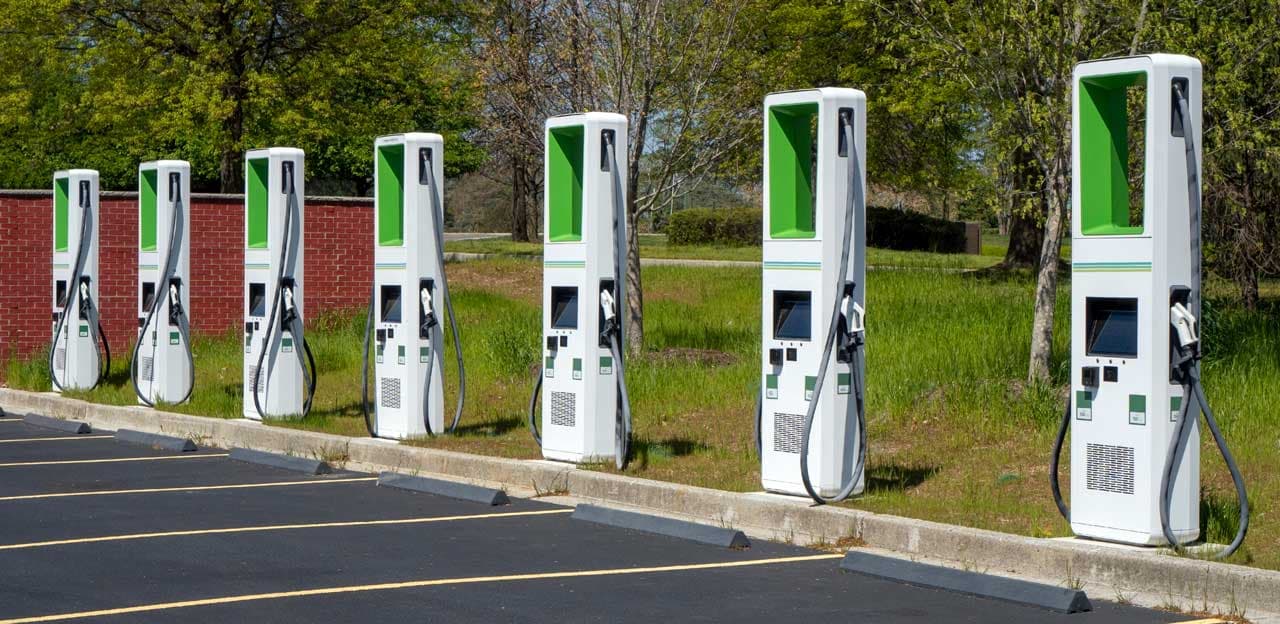
Example of a charging station with 7 visible stalls:
-
Use
man_made=charge_pointon a node for each charging stall or “charge point” (not to be confused with the operator “Chargepoint”). Sometimes also known as “dispensers”. Tags likesocket:type1_combo=would go on this node. There can be many of these per charging station. Oftentimes there are multiple “connectors” at each=charge_point, but they are typically fed by a single “EVSE”, meaning that only one can be used at once.
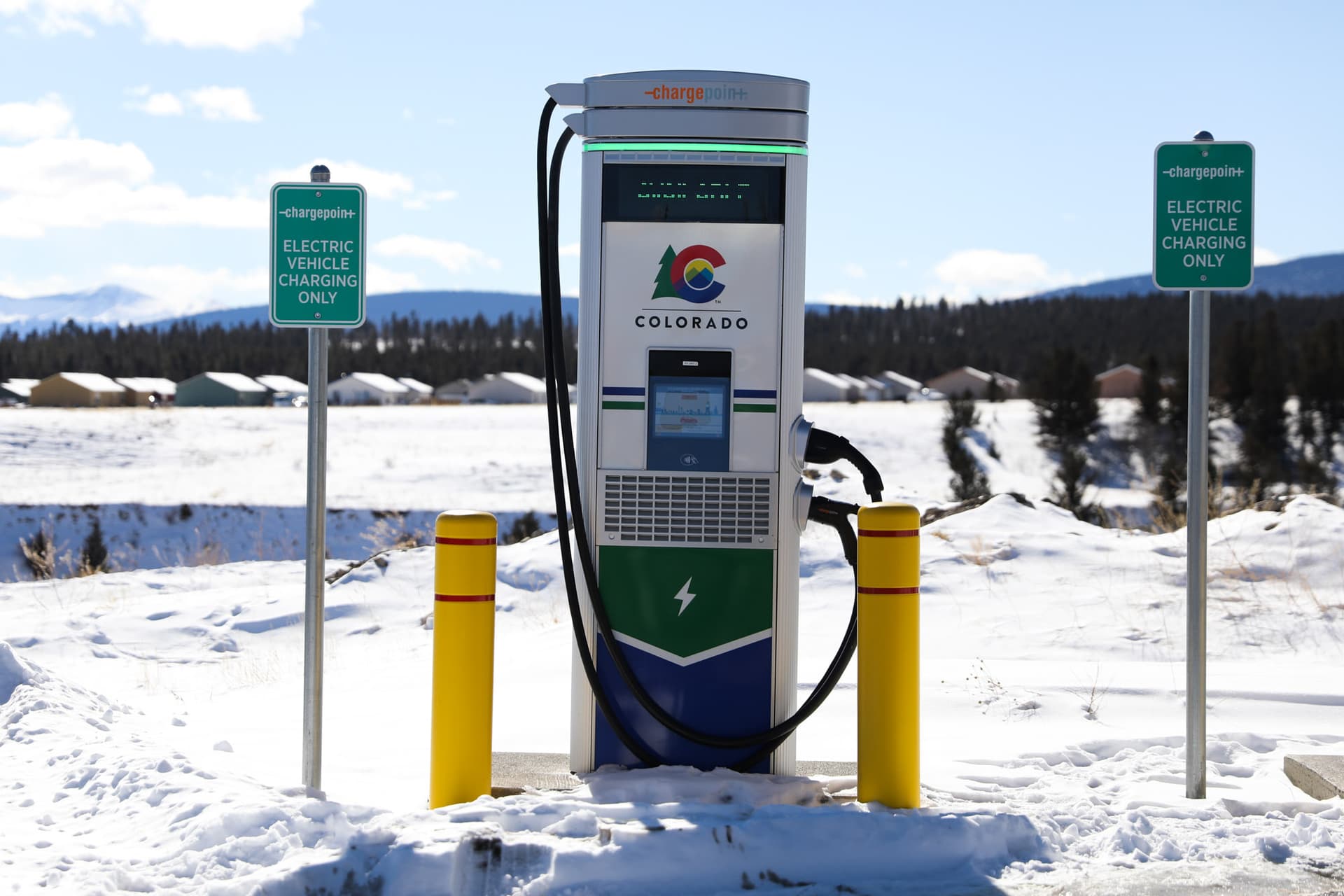
Example of a charging stall/point:
-
Use a relation containing the
amenity=charging_stationnode/way, surrounding parking used for the station,man_made=charge_pointnodes, street cabinets, etc. This is useful for applications to know what belongs where. I propose the tagstype=siteandsite=charging_stationon the relation. Roles for the relation members would bestationfor theamenity=charging_stationnode/way,charge_pointfor theman_made=charge_pointnodes,parkingfor the, well, parking, andcabinetfor the street cabinets. Minimizing the amount of tags on this relation, and putting most or all the general info on theamenity=charging_stationnode would be optimal, in my opinion. This and the charge points would be less important to map and render, as they only provide additional info.
Thoughts? Questions? My first time proposing something like this, so feedback is appreciated. Also, my view on this is rather focused on North America, because that is where I live and have the most experience and knowledge charging electric cars. I have used terminology from the OCPI standard wherever practical, in the interest of standardization and reducing confusion.
I hope I didn’t overthink all this ![]()
7 Likes
Not at all. I think you are onto something here. Still doing my own research but so far your proposal seems to be spot on.
2 Likes
Thank you!
This turns out to be a very productive thread ![]()
Minor comments:
-
I think it should be possible to map the site (
amenity=charging_station) only, withman_made=charge_pointbeing optional, reflecting current mapping practice in many countries. This means that at least the following two socket tags should be permitted on theamenity=charging_station:-
socket:<type>- the number of each socket type on the site -
socket:<type>:output- the maximum output available
-
-
I do not mind a site relation, but it tends to be complicated for many users, and there could be some overlapping tag issues with
amenity=charging_stationobject. An alternative could be a looser understanding that allman_made=charge_pointwithin an area (way) tagged withamenity=charging_stationwould imply that these objects belong to the same site.
1 Like
I was already thinking that man_made=charge_point is optional and only to add additional information, kind of like amenity=parking_space inside amenity=parking.
The idea without a site relation makes sense too. But I think we could have both, no? For those who want to map extremely detailed, the relation exists. But for others, just an outline is enough, and data consumers will assume that all man_made=charge_point inside are related.
1 Like
In general I agree with the proposed scheme. It solves the question.
I also thing “backwards compatibility” should be guaranteed.
1 Like
One of the issues with this, is that there may not be an obvious area. In contrast to petrol stations where the pumps are on a dedicated site, EV charge points can be put in pretty much anywhere. For example a series of charge points on street lamp posts could be considered as part of the same installation, but drawing an area around them doesn’t make sense (from a land ownership point of view).
I think we could do with a few examples of the range of infrastructure (from forecourt to street lamp changers) to test our proposal against and for showing examples in the wiki.
1 Like
Meanwhile, I ran an analysis of all amenity=charging_station on the planet to understand how many are individual charge points vs sites. I made the assumption that a group of nodes within 20 meters of each other are separate charge points on a site (the typical distance is 5-10 meters). Here are the results:
-
There are 6356 different clusters with nodes within 20 meters of each other, with a total of 17790 nodes. These nodes are likely charge points.
- 4441 of these clusters have 2 nodes only
- 811 have 3 nodes
- 542 have 4 nodes
- 192 have 5 nodes
- 141 have 6 nodes
- 51 have 7 nodes
- 57 have 8 nodes
- 12 have 9 nodes
- 29 have 10 nodes
- 80 have more than 10 nodes, up to 56 nodes at the maximum.
-
The other 69702
amenity=charging_stationnodes had no adjacent nodes with the same tag within 20 meters. They are likely separate sites. Some of them could be single chargers, so still a site but with only one charge point with, say 1-4 outlets. -
I also ran the same analysis with a 50 meters threshold. This produced similar results, with 7673 clusters of 21164 nodes (charge points), and 66328 separate nodes (sites).
So there are likely a lot more sites mapped than individual charge points within a site. I think this confirms that the amenity=charging_station tag should be used for a site rather than for the individual charge points.
6 Likes
Thank you! This is useful information.
I have made an example .osm file of how I would map a typical Electrify America charging station. How could I share that here?
2 Likes
Here is an example of a set of “On-Street” chargers by char.gy for us to test our proposal. As shown in G StreetView images there are a series of these charging posts along a service road in front of the shops. They are a little spaced out.
First question is would we map these as a single amenity=charging_station or multiple? If one, then how do we relate them together? Perhaps we may actually have to wait until the UK open data is made available to see how they appear in that (as a single “location” with multiple EVSEs, or as multiple “locations” each with just one EVSE)…
1 Like
Nice idea and great question. Maybe upload it to a file sharing site (OneDrive, Google Drive) and link to it from here.
These appear to be rather spaced out with other parking in between. I would probably map these as separate stations.
Here is a link: Charging Station Proposal Example Eugene EA.osm
1 Like
We should also find a way to map separately:
- Number of parking spots
- Maximum number of simultaneous vehicles that can charge
Here we have a lot of stations with 2 parking spots but only 1 DC connector can be used at the same time. It is good for different plug locations on cars, but creates confusion with the capacity tag.
Any proposals on this matter ?
I’d say that capacity= should show how many can charge at once. In this case, 1. I think this is documented on the wiki. Same for socket: - the number which can be used at once.
1 Like