Overnattet nettopp på Thon Hotel Oslo Airport og oppdaget at busstopp 9743 var plassert langt unna veien - nesten inne på hotellets parkeringsplass. Ble litt i tvil om Entur sin foreslått rutebuss faktisk gikk … Jeg flyttet noden nærmere veien, men når jeg leser denne tråden så bør den kanskje enda litt nærmere.
1 Like
Ja den lå feil. Har fikset i NSR og OSM nå.
1 Like
Ah, takk!
Jeg kan kanskje tagge den med shelter=no og pole=no for å markere at den er “usynlig”?
https://wiki.openstreetmap.org/wiki/Tag:highway=bus%20stop?uselang=en
1 Like
Where: (ref:nsrq 70203) Node: Hopen sentrum (6372445679) | OpenStreetMap
What: Adjust position north by 29 metres
Busses actually stop slightly further north, east of the Coop building (surveyed), and never in the turn by the parking lot where it is currently mapped (which is an inconvenient place for a standing bus).
The little bump on the east side of the building (node 8827697737 is a corner) is a bus shelter. This has shelter=yes, bench=yes and bin=yes. The shelter has a bus sign.
1 Like
Moved Lørenskog sentrum bus stops A and B to better locations now that the street has been rebuilt. New positions are (barely) visible in NiB so the position should be pretty accurate.
Thank you. I’ve left a note for Ruter on this matter.
1 Like
Fant noe småtteri i Skien:
Where: (ref:nsrq 36616) Node: Tuftebygget (10763052619) | OpenStreetMap
What: Plassert på en parkeringsplass. Skal litt østover.
Where: (ref:nsrq 36620) Node: Tuftebygget (6372704544) | OpenStreetMap
What: Veien er bygget om, så stopp er nå midt i veibanen. Skal litt østover.
Tuftebygget er oppdatert i NSR nå ![]()
1 Like
Mindre endringer i Tyholtveien i Trondheim - Cecilie Thoresens veg:
Where: (ref:nsrq 75585) Node: Cecilie Thoresens veg (2184041539) | OpenStreetMap
Where: (ref:nsrq 75582) Node: Cecilie Thoresens veg (2184041538) | OpenStreetMap
What: Nybygget sykkelveg med fortau, begge busstopp flyttet litt vestover.
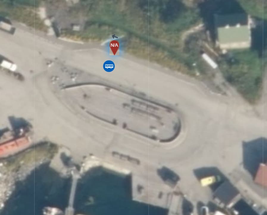
Where: (ref:nsrq 68882) Node: Straumen (6372450264) | OpenStreetMap
What: Adjust position northwest by 40 metres
Actual location of the stop, surveyed on site.
(Do upstream changes actually happen, or has this import effectively caused bus stops to be impossible to correct in OSM?)
you mean like this?
Upstream changes do happen, but sometimes eventually. The fylkeskommuner are responsible for doing this. Sometimes I do it for them with obvious easy fixes, but sometimes I leave them a note and they’ll do it when they do it.
Red marker is spot on
Good. I’ve saved the change in NSR ![]()
Dont move or rename the stops
I will be renaming stops form now on, as the suggested process for reporting errors does not seem to have any effect.
which stops?
ref:nsrq 73067, 71282, 73480, 73830, 71761, 72337, 73084, 71149 (name)
ref:nsrq 70203 (position)
If you edit the names for yourself according to your own opinions they won’t match the stop names in local and national journey planners. I know you disagree with the names but wrong names are better than mismatching names. I can nudge AtB about it and see what they say.
Your inputs are still registered in NSR, just not processed by AtB yet.
Enklest å legge inn loc_name=* ?
Blir vel minst friksjon slik inntil vidare.
@sbre Nå har jeg ringt AtB og purret litt ekstra. Har god tro på relativt rask behandling nå ![]()