Bolt letter to OSM Community

Hello Austria OSM community,

We at Bolt are happy to introduce our company, our mission and, most importantly, our mapping objectives in Austria.

As a company, we are more than just another ride-hailing service. We’re on a mission to build cities for people, not cars. Committed to reducing the environmental footprint of mobility, we are fighting for better cities and a greener future by offering a better alternative to every purpose a private car serves.

Building a sustainable future is a goal Bolt and OSM have in common. Just like we care about our customers’ needs, people who contribute to OSM care about their communities’ prosperity.

OSM members create more than maps, they design a vital tool to improve the quality of life of the community.

Accordingly, where there is an active OSM community, there is good data coverage. In turn, it means that we can provide better services that make OSM a valuable part of data we use, along with other open and proprietary data sources. Bolt thrives for synergetic interaction with the OSM community. Being passive users of the data is not an aspiration we share, as well as tailoring an already well-functioning ecosystem of OSM to erroneous ends. Instead, we are willing to assist the community and become a part of it by resolving certain set of issues, such as improving road configuration, adding missing roads, one ways and turn restrictions, along with others.

You might have already noticed edits made by members of our team. Together with developing our operations in Austria we also aim to lay the foundation for a healthy dialogue, including constructive criticism, and further cooperation with the Austria OSM community.

You can find more information about our current work with OSM in this GitHub repository or on our Wiki page.

Feel free to reach out via messaging Bolt024 or Bolt051 .

Sincerely,

Bolt
Welcome to the community, glad you want to be active here, we really appreciate it.

In the GitHub are referred to MapRoulette. But for Austria there are no links at all. Where can we find them?

In the wiki entry it is referenced that there is a list of aerial images used. Unfortunately, this is missing.

I would appreciate it very much if you share the planned changes in advance. Like TomTom or MapBox already does.

Also, it would be desirable if you share the GPS traces on OSM as well, so that we could all benefit from the anonymous data.

Thank you very much!

1 Like

Hello. Thanks for asking.

We did MapRoulette just a single time for Accra.

We mainly do edits regarding POI, TR, OW, VA si MR on continuous bases.

The GPS tracks and aerial images that we are using are those provided in OSM.

Thank you for the interest!

If you don’t use MapRoulette at all in Austria, why do you bring it up in your linked wiki entry?

That’s nice what you change / want to change. I would just like to see before your edits what you change in our community. TomTom and Mapbox get it right actually.

That means the “Bold GPS traces” described in the wiki are actually not “Bolt” GPS traces but the general GPS traces of all OSM users?

OSM provides many aerial images such as Maxar Premium, which are unusable in this country. Instead basemap.at provides aerial images with much better resolution.
From what I’ve seen, you guys are using Maxar for the most part in your changes.

An die Community:
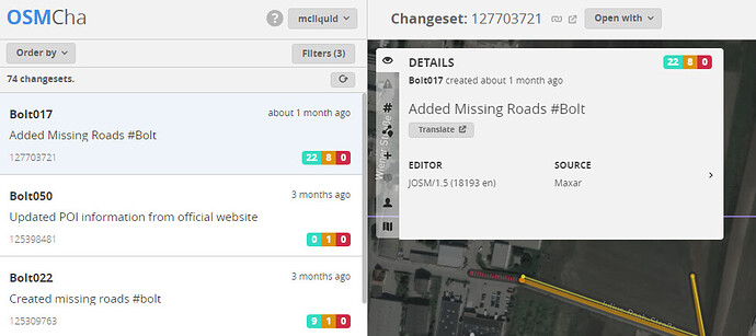
Wer sich selbst ein Bild machen möchte kann dies unter folgendem Link bei OSMCha einsehen. Der Link enthält Österreich als Multipolygon sowie alle Bolt-User (auch die, die nicht im Wiki aufgelistet werden!).

Dein Link produziert leider ein " Bad Request - Request Line is too large (7279 > 4094)". Klingt nach einer serverseitigen Einschränkung.

Hi again!

Our wiki page is not just for Austria, because we do edits to more countries across Europe, Africa…

Our edits are made just to reflect what is in reality using as you said for many areas Maxar Premium Imagery, Mapillary etc. We can find about the best sources of information regarding the aerial images just from the community because you know it better.

Thanks for the info related to basemap.at.

Dieser Link sollte aller User filtern.

Und dieser Link sollte inklusive Austria als Polygon sein.

Letzteres ergibt dann (zumindest bei mir) folgende Ansicht:

1 Like

As far as I can judge, most of the changes are taking place in the greater Vienna area, as this is probably where Bolt’s offering operates.

Most changesets consist only of single changes, mostly missing highway=service or barrier=gate. Rarely also individual POIs (bars, stores, etc.).
I have noticed nothing seriously negative in the last 100 changesets.

As a suggestion for improvement:

  1. when using basemap.at aerial images, a significantly higher accuracy could be achieved compared to Maxar.
  2. if #Bolt would be used consistently in the changeset comment, the changesets could be assigned much better.
  3. at least for changesets older than one year, often no changeset comment was given at all. A short explanation of the changes made helps enormously here.
  4. very important: sometimes a changeset was commented by other mappers and you never replied to it. This is not how we want to deal with each other here! If you want to be involved as an organized unit in OSM, then please be available like everyone else and respond!
    Example 1: Changeset: 105340790 | OpenStreetMap
    Example 2: Changeset: 116870590 | OpenStreetMap

If you follow the above suggestions for improvement, I don’t see any problems with contributions from your organization to OpenStreetMap Austria.

4 Likes

Thank you! We will do as indicated!