ctrl + click works even for bbox on map
3 Likes
It certainly does! ![]()
Thank you! ![]()
Some people have an opinion that you shouldn’t view too many changesets at once. One number I heard is 20, so that you don’t display more than 20 changesets. In this case the map view will be uncluttered.
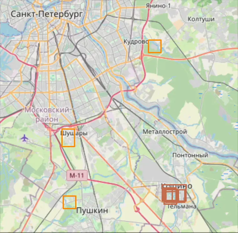
But you’re not one of these people because you have the Load 300 button. If I press it, I’ll get a sea of orange bboxes which is going to be difficult to navigate.
The presence of the Load 300 button does not mean that I always use it)) This is a crutch button to load enough changesets for filtering. If you don’t take a city with active cartographers, then there will be a bunch of large bboxes in /history that I can filter out. (or hello to the OZON map team, which floods changesets)
The problem is different:
- With the script, more changeset are placed in the sidebar in the visible area
- Now on the map you see in the worst case 4 similar bbox colors:
- changesets above
- visible changesets
- changesets below
- changeset under hover
If earlier I could hardly find the edit under the hover because of the bad color, now there is even more color noise among which I need to find the active changeset.

I would take the risk to try not to show any non-visible (in sidebar) changesets at all ![]()
Also, sometimes the hover fails and the bbox ends up not on top of other bboxes:
Alternatively, I want to play around with different bbox colors for different users, as done in Easy Changeset Viewer(ver 2025/03/29) and a hover for the usernames that highlights all their changesets

But I have to admit that this only works because of map discoloration
But if you dig deeper, only JOSM and iD’s built-in ability to split changeset into several small ones can put an end to interfering bboxes. Or an API that provides meta information about clusters of objects in changeset.
That’s a different problem. The color noise already exists on the map because can be arbitrarily colored. We may need to add an extra outline to bboxes that are supposed to stand out.
This is hopefully going to get solved by having another layer on top just to display hover highlights. That has to be a pointer-events: none layer.

Or change the color. For example, black is much more noticeable (even though it stands out from the color palette)
Perhaps now for simplicity you can use .bringToFront() from Leaflet
I use the “show next 300” regularly. I find it usefull ![]() Cluttering the map is in that case my own fault and also explicitely wanted - not a problem.
Cluttering the map is in that case my own fault and also explicitely wanted - not a problem.
3 Likes
Same, I’m also a big fan of the “load 300” button
1 Like
There is a bug that drives me with its insidious suddenness. Today I met him for the fourth time. I always encounter it at night, it seems around 00:00 UTC (I hope this isn’t just another developer Easter egg :ㅤ) and it is always resolved by restarting Firefox.
I open several tabs with changesets, click on the link to the next changeset, and notice that some of the script functions stop working. For example, the comment field is not compressed to a one line. Reloading the tab doesn’t help. If anyone has noticed this behavior, please tell me which browser and script manager you are using.
Technical details: as a result of debugging, the problem always boils down to the fact that Firefox stops calling the MutationObserver handler. I suspect that this is a Firefox bug or Tampermonkey influence, but I have no idea how to prepare a reproducible environment.
2 Likes
Well, my plans for v1.0.0 turned out to be complicated, but a lot of useful little things have already accumulated, so today is v0.9.9:
Partial revert of changesets
Press R and select the objects you want to revert using the checkboxes. And press ![]() or
or R:

Important: if you want to revert a node accidentally sticking to a way, you must select both the way (to remove the node from the list of nodes) and the node (to revert the coordinate)
p.s. You can use Tab/shift+Tab, or K/L to select objects.
3D view of buildings
Do you know about Showing off my 3D building renderer - General talk - OpenStreetMap Community Forum ? Now you can try it right in the browser: Way: Cathedral of the Nativity of Christ (419266377) | OpenStreetMap

Of course, you can use other 3D viewers, just right click:

upd: Please update to 0.9.9.3. Fixed a bug due to which clicking on ![]() resets your templates for responses to comments and notes.
resets your templates for responses to comments and notes.
JOSM in browser 
More madness. You can replace iD with JOSM:

Demo and read more:
Other:
KandLkeys now work for changeset list and search results.
|
|
|


p.s. Remember that there are hotkeys in the browser ctrl/shift + enter
- You can again navigate between changesets by deleted users:

-
Key
1opens the first user changeset from changeset page -
Key
Jnow works for object pages like/node/123. As a reminder, KeyJopens the object in JOSM, andalt+Jin Level0. Of course, by pressingRyou can select several objects using the checkboxes. -
Thanks to @Martinligabue, the last satellite layer is now opened instead of the permanent ESRI layer. The
poweruser=trueparameter is also added by default. Did you know that in Rapid you can disable the restriction on editing large objects? -
Thanks to @Dimitar155, switching compact mode on the
/changesetpage has become much faster -
alt+Sto reset the tile cache without reloading the page. Unfortunately, this does not replacectrl+F5, because it resets the cache only for the tab, i.e. after reload you will see the old tiles.
12 Likes
Sounds cool! Unfortunately fails for me (3D render does nothing in 0.9.9 · Issue #279 · deevroman/better-osm-org · GitHub)
Ok, yeah, but does it run on Minecraft ? ![]()
In Firefox on Linux it also opens “Hi(s)tory” menu ![]()
hmm, does this prevent this menu from opening? or do the tiles reload and the menu open?
Both the menu opening and tiles reload happen at the same time
Found a nasty bug. When you select another 3D building viewer, the template buttons for comments on edits and notes are reset. Please do not click on ![]()
upd: fixed in 0.9.9.3
1 Like
Whoa the integrated 3D view looks really cool, but what’s wrong with this tower ?

Looks fine in F4map:

Getting it to show as is shown with all the platform is a serious tagging achivement, chapeau, not to speak of the prowess of the F4/SGL render engine powers. But, F4map and StreetGL show the same problem… floating buildings and seemingly using the slope of the land so one side is higher than the other
Nothing. F4 does not render the outline because it’s filled with building:parts.
Some renderers do not seem do this appearently.
1 Like
Yes, this is a known problem with this viewer: Building outline always rendered · Issue #69 · Beakerboy/OSMBuilding · GitHub
There are two ways to get around it: open the type=building relation. But in this case there is no relation.
But there is a bug due to which parts of the neighboring building are displayed and this can be used (: Way: 122581514 | OpenStreetMap

1 Like
This bug has been fixed in the main version of the viewer OpenStreetMap Building 3D Render The userscript uses a link to my version of this tool with fixes for several bugs that have not yet been merged into the main branch. upd: fixed
Stay tuned ![]() , maybe soon we’ll be able to show some killer features of this tool. Do not hesitate to put
, maybe soon we’ll be able to show some killer features of this tool. Do not hesitate to put ![]() GitHub - Beakerboy/OSMBuilding: render an individual OSM building
GitHub - Beakerboy/OSMBuilding: render an individual OSM building
6 Likes