Can these discussions be held on this forum so we can all participate? Not all of us have the time to be part of the US trails working groups, and there may be people outside the US who could benefit from participating in, or observing, the discussion.
Well, a significant number of the issues in the “diff” file I posted appear to be issues with your data and not OSM, although OSM too has a number of issues (some of which I have fixed).
Thanks this method is very useful and we can use it for tagging to avoid errors.
You mention in this video to only add data that has evidence it exists rather than planned trails etc… So, for the trail mentioned earlier near 40.717738, -111.5496993 (Pawmaste), where it does not show evidence that it exists according to Strava heatmaps or aeriel imagery, I’m curious how we get the community support to add the trail. Since it does exist and is open to the public, is it enough that we are the trail builders and managers that we add it with our GPX tracks?
1 Like
If you really, really, really know that it exists, then yes, but in a large (or any) organization often the left hand doesn’t know what the right hand is doing so I would double check. If you have been on the trail personally, then absolutely go ahead and include it straight away, otherwise, given the issues with these data, I would urge you to double check. Fankly, I find it suspect that there is a trail of any type that has been open to the public since October where there is no Strava heat. I know a lot of Strava users that record activities (run, walk, hike) with their dogs. Many are quite obsessed with recording every little bit of physical activity.
I did intend to make a more comprehesive video, but haven’t gotten the time.
BTW, did you check out the diff file I linked to?
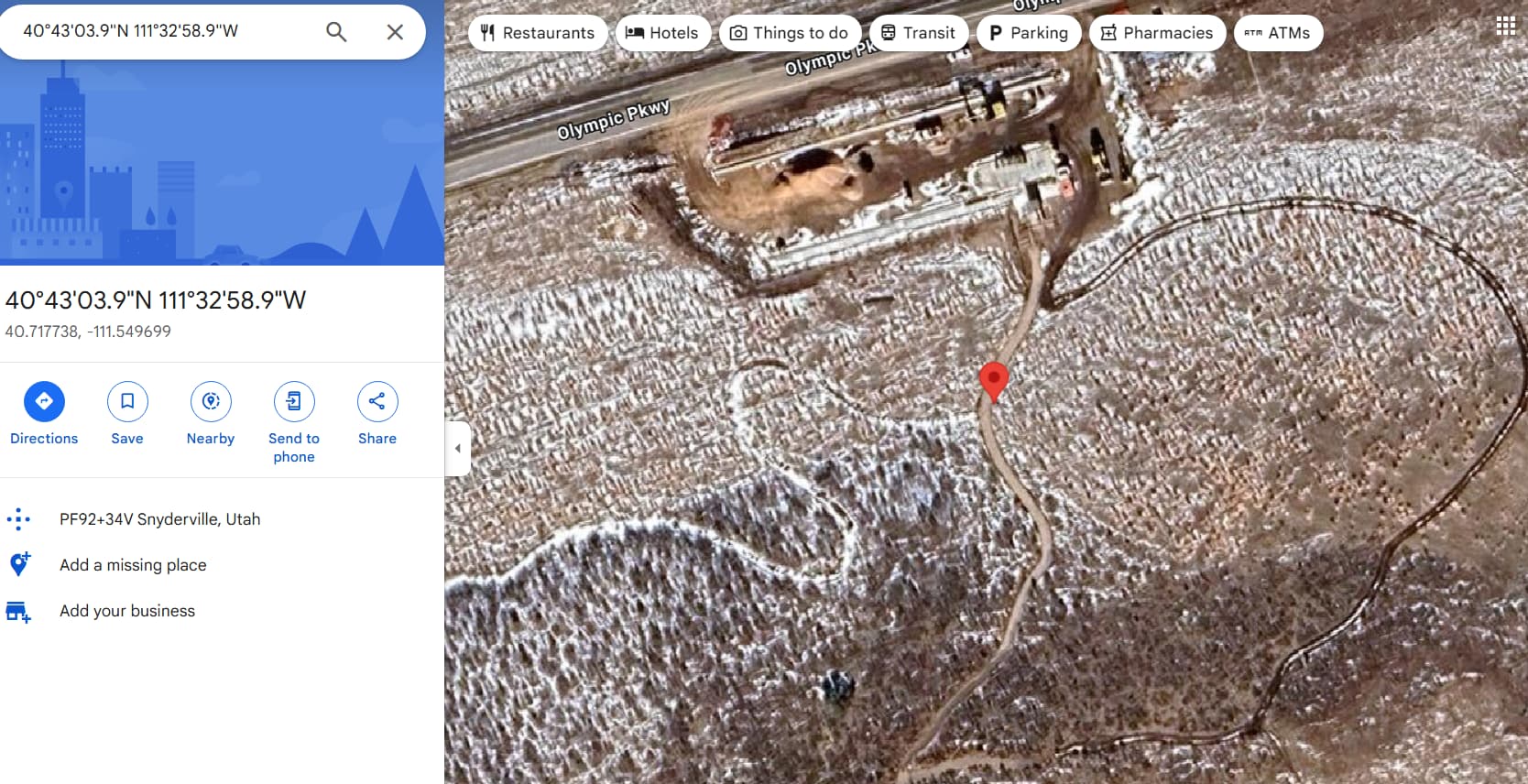
The new trail Pawmaste, along with the new trailhead and parking lot are on Google maps, so I do not know why it is not on Strava heatmaps or other aerial imagery, but it does exist. Myself and @Seychelle_Marcus are in the Trails and Open Space Department, who is in charge of building and managing the trails, so we have personally walked it to get a GPX track, as a well as used it leisurely.
I do not want anyone to feel uncomfortable with our edits, so be assured that as the land managers, who work on the ground, we will not be adding or amending any trails that we are not positive about.
Yes I am taking a look at that this morning, thank you.
We will plan to use multiple sources when making our edits, as our goal is to make OSM data as accurate as possible.
Hi @tekim, I think there is a separation of understanding and translation from the OSM data side to the GIS data side. Referring to our bike park trails in screenshot #4 of this thread: Our GIS trail data that you are looking at is translating the feature layer onto your map in the direction that the line was drawn, this is not representative of the direction of the trail traffic, this is simply how the data was drawn to create it. That is how GIS data works. Again, this data is meant for manual reference and amendment of OSM data, if a user is unsure of the data then they shouldn’t be making edits or addition to OSM data to retain accuracy.
Referring to this screenshot you can also see that our trail crew reworked the trail alignment in the area this year, and this has not been translated to heatmaps nor does OSM data reflect the correct trail alignment. Again I will reassure you, as public servants and employees of the County in this area, we are simply trying to aid the public community by updating the trail alignments with the most accurate data possible. The trails in our bike park are accurately reflected in our data and incorrectly reflected in OSM data. Luckily, through the OSM community mapping process, this community will be able to assess our corrections when we upload them to OSM, and they will be able to confirm that the trails are indeed accurately reflected in the gpx tracks and on-ground data that we have collected. In other cases that we are not sure if our track or OSM data is more correct, we are the on-ground field workers and specialists so we will be able to identify which trails we need to get a new alignment for and which ones we need to translate to OSM data.
I am traveling so can’t respond d in depth. I have fixed a lot of the positional errors in OSM. Analysis should be rerun. Re dog park: other trails in it have heat, e.g. up dog and down dog.
1 Like
When you have time I used your diff file to add the Pawmaste addition to OSM, if you would like to check my edits. Thanks
I only have my phone at the moment, but there might be some criss crossing geometry where the two loops come together, and or double ways/polylines. Otherwise looks good to me.
1 Like
I looked at the edit with my laptop. Looks good to me. Others may have suggestions. I see @Seychelle_Marcus added dog=yes, that is great! Consider adding horse=yes/no as applicable. One little nit:
I doubt the two trails run parallel within 1 foot of each other for 15 feet given that the trails themselves are probably wider than one foot. Again, just a small nit.
The only positional work left to do should be the mtb jump lines and mtb skills areas (but double check). Then we can start talking about correcting tagging of existing trails and marking informal trails.
We should keep an eye on that trail to see if any Strava heat shows up. Perhaps there is a glitch in Strava, but if not it is very strange (maybe no one is using the trail due to winter snow and/or mud?)
Most certainly! This is the core of openstreetmap, local knowledge. If there is blank space in Strava but I walked the trail, and there is a path on the ground, especially a constructed one, not just a so-called social trail, nothing should stop me from adding that. With informal trails it gets a bit more complicated, sometimes informal=yes on a highway=path fits, sometimes it might be just a game-trail, so some care advisable before adding a highway=*.
2 Likes
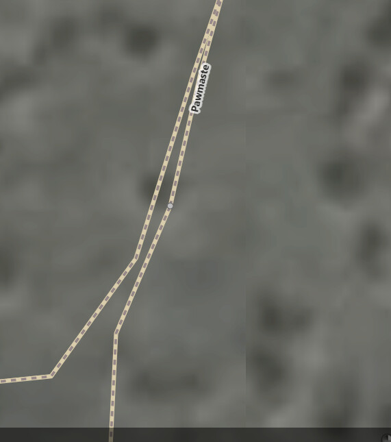
Hey @tekim, yes as far as I can calculate it looks like the Pawmaste trail appears in your screenshot as having two parallel tracks because we tracked this with a GPS unit, accuracy can be 5-15 feet off.
The bike park trails are certainly as correct as we can track them, they were also tracked on the ground with a unit by me personally. So the only way that we can get more accurate data is double checking this with heatmap or imagery - but keeping in mind that a lot of the heatmap an/or imagery shows the old trails that were rerouted and also social trails. As mentioned beforehand, we are on these trails consistently throughout the year so we will note any discrepancies that we notice via on ground observations.
If the evidence doesn’t fit the theory, judgement as to the correctness of the theory should be at the very least reserved until more investigation is conducted. I have seen a significant number of errors in the trail data from land managers, and I have pointed out a number of issues with the data in this case (some of it just plain sloppy GIS data management, e.g. overlapping geometry, gaps in geometry, etc.). With this data, sometimes there is no other Strava heat around, suggesting it is not a case where the trail has been rerouted (if there were two bits of heat that would suggest a reroute took place within the last year, one for the old reroute, one for the new, and there does appear to be some of those). Unless you have just rerouted a trail in the last few weeks, or it is closed to the public for some reason, it should show up on the Strava Heatmap.
Again, this was just a minor concern (a “nit”), However, it does point out that ideally raw GPS tracks should not be put into a database (except as a reference). That trail junction is probably at the southern end where the two lines start to converge. Again, a minor concern.
Another little bit of feedback, you should not add hashtag=#basinrec to OSM features (you can add it to changesets).
I am still traveling and do not have the ability to do any additional in-depth analysis. Prior to starting my travels I did make a lot of positional corrections to the OSM data (no tagging corrections yet).
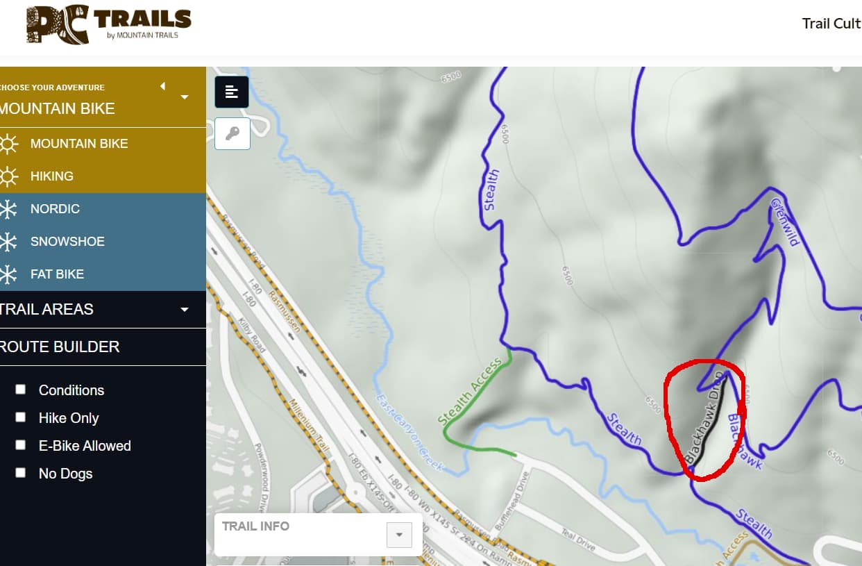
@astotes I noticed that you edited this way: Way: 1030483133 | OpenStreetMap setting access=no, and informal=yes, and deleting the name tag and the specific access tags but the official map at Interactive Map clearly shows this trail (Blackhawk Drop):
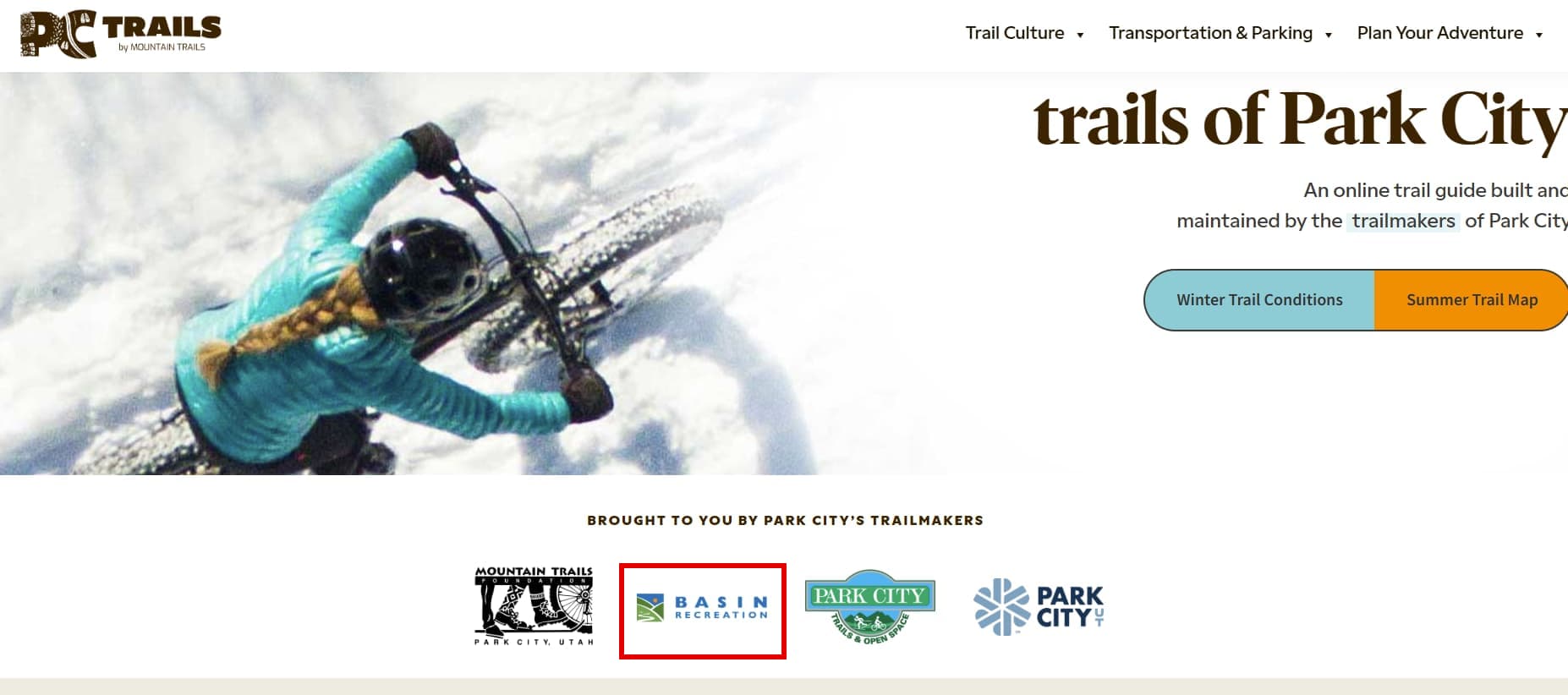
The website hosting this map displays the “Basin Recreation” logo, so presumably your organization provides (or endorses) its content.
In any event, even if this trail were “informal”, I would not delete the name tag. Also, I would only add access=no if someone could be ticketed if they were found using the trail. Around here many places allow off trail use, so someone would not be ticketed for using an informal trail, but if someone were to be caught building their own trail (or modifying an official trail), that would be a different matter.
@astotes I noticed that you edited this way: Way: 1030483133 | OpenStreetMap setting access=no, and informal=yes, and deleting the name tag and the specific access tags but the official map at Interactive Map clearly shows this trail (Blackhawk Drop):
Hi @tekim,
The map that you are referring to is a map that all agencies in the Park City area use as a reference. This map is based off off Strava heatmap data, and it is NOT accurate. We are in touch with the developer who creates this map, but they do not reflect all of our trail data accurately. This map can not and should not be used to edit OSM data. As we have let you know previously, we are the Trails and Open Space team of Basin Recreation. We are the on-ground managers of these trails, and we are only making edits to OSM data that we know are accurate. The “Blackhawk trail” section that you are referencing is a very bad social trail that runs straight down the fault line. It is user created and unsustainable. We manage these trails and our goal is to enhance sustainable trail use that doesn’t negatively impact the area, the vegetation, the wildlife, the watershed via erosion and water rerouting. Additionally, this property is held under a Conservation Easement by Utah Open Lands, and Basin Recreation is at our max capacity of trail mileage legally permitted within this area. Please understand that advocating for responsible and sustainable trail recreation is crucial aspect of managing trails, and that trails are a privilege that users should be respectfully using as to not negatively impact the area further.
I am not sure what you mean by “use as a reference”, but the website certainly gives the impression that it is officially associated with your agency because they display your logo, and because basinrecreation.org links to it. Based upon changeset comments from the past, I suspect it has been used to edit OSM. Perhaps they should add a disclaimer that they are not affiliated with you or any other land manager?
Yes, I understand that, but that doesn’t mean your data is perfect (there are many issues and suspected issues already detected), so you will forgive me for “double checking.” I will say that most of the edits to OSM so far look pretty good - a couple comments on that further down.
I am not arguing for the creation or use of social trails, only the accurate depiction of the on the ground situation. In this case you provided some very helpful additional information as to why a website that presents itself as officially associated with your agency is in fact not associated with your agency, and therefore we cannot trust it. That was certainly not obvious, and I have seen many other cases when land manager GIS data doesn’t agree with their websites or printed material.
Nevertheless, I think the name should remain if that is what locals call it. One can imagine an responsible trail user using the name: “dude, we shouldn’t ride the Blackhawk Drop trail, it is closed to protect the environment”
Some feedback on the edits I have seen so far:
access=private, bicycle=designated may be understood by some data consumers as a meaning that all use is private, except for bicycles which are allowed regardless - which is probably not what you mean. Consider just access=private, or just bicycle=private.
Make sure to connect trails to the rest of the trail network if in reality they are connected. I have seen a couple examples where they were not.
Hi, this trail in particular is a social trail that has been heavily used and is incorrectly represented on the PC Trail map due to this map using Strava Heatmap data. This is a great example of why we wanted to make changes on OSM in particular as we have reached out to the developer of this map to make changes, however there is slow response. Since it is based on the Strava heatmap it would show that trail being used often, however we do not want people using it and our Rangers could in fact give out tickets for people entering designated open space areas and using informal trails.
For trails on OSM that are no longer there that used to be, I understand that it is not recommended to delete information so to keep historical data. In this case I deleted the name as it is not an official trail nor was it at any point so I thought that would be most appropriate as to not confuse this as a real trail.
I tagged access=no and informal=yes as that was a recommendation from earlier in this chain from another user. I would like input on how to go about this particular situation from the community so I have also posted this question on the trails slack regarding this access tag and deletion of the trail name.
1 Like
Follow up on the access tag.
Members from the #trails slack informed that
“It depends on the local regulations and rules set by the land manager. For example on USFS managed land, people are generally allowed to go wherever they please, including traveling on unofficial trails. So access=no would be wrong in this case, even if a trail is unofficial. But on the other hand, many National Parks have specific rules (signed on the ground and/or in official materials like the website or brochure) about only traveling on official trails, so in those places adding access=no to every unofficial trail would be correct.”
Also found on: United States/Trails Stewardship Initiative - OpenStreetMap Wiki
A social trail, and access to this social trail, or social trails in general, is prohibited by the land owner/manager.
(as evidenced by posted signs or markings, or by text on e.g. the official website or visitor maps) * highway=path
- informal=yes
- access=no
A social trail, and access to this social trail is not prohibited outright, but is officially discouraged by the land owner/manager.
(as evidenced by posted signs or markings, or by text on e.g. the official website or visitor maps) * highway=path
- informal=yes
- access=discouraged
A social trail, and access to social trails is not prohibited or discouraged by the land owner/manager * highway=path - informal=yes
We will be following this guideline to maintain standardized tagging of trails and ensure responsible mapping and use of trails. As the land owners/managers we explicitly prohibit use of social trails in our open spaces as they are accessible only through designated trails. In areas where it is not explicitly prohibited we will use access=discouraged.
I have done some checking of this organized editing activity and have some feedback.
-
Make sure that trails in OSM are connected to the larger road and trail network when they are in reality connected. I have seen a couple of cases where trails have been disconnected.
-
The name tag is for the name of the feature only, not for additional information about its status, for example, don’t append “(closed)” to the value of the name tag. OSM has tags to describe the status of a feature. If in doubt about the appropriate tagging, ask here.
-
Just because a trail is informal, doesn’t mean it doesn’t have a name. I have seen at least one case where the name was deleted when a trail was tagged as informal=yes.
-
This has been discussed before in this thread, but tagging that goes something like this access=private, foot=no, bicycle=no might be interpreted by some data users/consumers that there is some private group that is allowed to use the trail for horseback riding (but absolutely no one can walk or bike on the trail). We can argue as to whether this is the “correct” interpretation, but it is best to be as clear as possible in the data. If one access constraint applies to every type of travel, use the access=
*tag and remove bicycle=*, foot=*, horse=*, etc. (or don’t use the access tag and use the individual tags, just don’t mix them [in most cases]). If different restrictions apply based on the mode of travel, omit the access=*tag and just use bicycle=*, foot=*, horse=*etc. As discussed before, you most likely don’t want to use access=yes here, but you may want to use access=no as long as you remove the other access related tags, e.g. bicycle=* -
Some of the trails that have been added or edited are “over noded”, that is they have way more vertices (nodes) than is necessary to represent the trail. JOSM has a function to help with this: Tools → Simplify way. I use a setting of 0.25 meters, but some may think that my work is “over noded” too.
-
Generally, if a trail is not one way, we do not tag it as oneway=no as this is the assumed default. An exception can be made if there is some reason why people might make the opposite assumption.
1 Like