I wonder what’s the best map for hiking?
I tried openmtb maps (they say it’s for hiking).
I like the map looks with waterpoints other handy things.
But when navigating it never takes the hiking pathway but cycle and auto ways.
I only navigate with my gps and never with Basecamp I just have an walking profile.
i tried so many maps but only the Topo and standard garmin cycle map (OSM map as is delivered with the Edge 1000, NOT garmin.openstreetmap.nl) seems to navigate with prefer for trails (no cycleway) in profile walking.
But i cannot afford topo maps for all the countries where i want to go and the standard OSM garmin map just doesnt look good enough.
There is no such thing as “standard OSM garmin map”. Thanks to the open data and open source, a lot of providers are compiling free OSM maps for garmin devices, and several of them also release the scripts and configurations they use, so if the map just doesnt look good enough, you can tailor to your needs and make your own maps.
With standard OSM map i mean the map that is standard with the edge 1000.
This map hasnt got the poi like waterpoint en viewpoint like different OSM maps.
openmtb unfortunatly doenst navigate on footways.
it preffers cycleways so when navigating it will choose the cycleway when there is an footpath parallel.
I really like the openmtb style though.
-openmtb
-garmin openstreetmap (new style, normal)
-openfietsmap
-freizeitkarte
-topo benelux
-garmin opencycle map (as is delivered with edge 1000)
only the last two seems to be navigation on footpath’s preferred.
i will try the openstreet map url you provide.
i cannot image that i am the first user that finds this?
Edit:
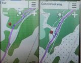
this is what I mean left with garmin osm cycle map.
It navigates through footpath, right is way all other maps navigate, trough the cycle way (when both ways are parallel).
on my gps64 I have to select ‘hiking’ and not’ pedestrian’
Unfortunately most if not all custom maps are not designed for hikers
As hinted before the solution is to create your own maps
I have changed the class and speed values for cycle paths to those reserved for a primary road.
Bit of an overkill but it works. It requires experimentation and also depends on your device and NOT Basecamp
However , it does not affect its ‘look’ , ie colour & pattern and if there is an obvious detour I can always select ‘Pedestrian’.
Unfortunately the NON NT imgs can not easily select active routing and opt for a longdistance route, like the GR in your area.