For piste:type=skitour, piste:difficulty=* wiki definitions refers to the SAC scale for ages, hence the 55°. Maybe the link should be made more visible.
And here is already the big difference:
I try to find a good mapping for Alpine skiing (piste:type=downhill).
The problem seems to be that for both piste:type=downhill and piste:type=skitour the difficulty is given with the same nomenclature (piste:difficulty=).
Now when I try to map an official ski route specified by the ski resort, this is definitely piste:type=downhill. The difficulty is typically not specified for these routes. (Very very few resorts nevertheless classify them with blue-red-black).
Since these ski routes are given without rating, I tag them with “piste:difficulty=freeride”. In german, the translation for this is even “off-piste”, which fits wonderfully with the route.
So my suggestion would be to rename the existing Freeride to “Exceptionally Difficult”, which is what it actually represents.
…and to introduce a new value for such marked ski routes that have no rating. Whether the designation “Off-piste” would make sense, which actually means “Off-piste without any further rating”, remains to be seen.
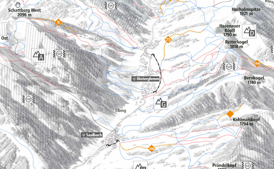
The photo shows the piste map of Saalbach Hinterglemm. There are several such ski routes there. These are far from jumps over cliffs or 50% drops.
I am at a loss just the same. Nowhere does the SAC call the skitours between 50 and 55° slope, where - during ascent or descent, quote - falls often fatal, by the name “freeride”. They call them “Exceptionally Difficult”, c.f. https://www.sac-cas.ch/fileadmin/Ausbildung_und_Wissen/Sicher_unterwegs/Sicher_unterwegs_Skitour/2020_Skitourenskala_EN.pdf Perhaps, the OSM wording comes from the term free-climbing? There its used like that. But in skiing, freeride means ungroomed backcountry downhill, IIRC.
‘freeride’ is not a word, it’s the value of an OSM tag.
I understand piste:difficulty=novice/easy/ … /freeride/extreme is intended to be a progressive scale that was later applied with the same values for piste:type other than downhill.
Could have been piste:difficulty=1/2/3/…
Now piste:difficulty=freeride stands out from the list of values, it is something different in natural language.
A bit of archeology:
The value difficulty=freeride appeared on the wiki in 2007, associated with european ‘yelow pistes’.
https://wiki.openstreetmap.org/w/index.php?title=Piste_Maps&oldid=43021
The first definition of piste:type=skitour:
https://wiki.openstreetmap.org/w/index.php?title=Piste_Maps&oldid=363081#Type
And the piste:difficulty applied to skitour baxk in 2009:
https://wiki.openstreetmap.org/w/index.php?title=Piste_Maps&oldid=378735#Difficulty
So, my understanding is that applied to piste:type=skitour, piste:difficulty=freeride just means SAC “AS”, ausserordentlich schwierig = “Exceptionally Difficult” in OSM tags. Nothing to do with natural word ‘freeride’.
Mappers seems to follow this scale when they bother to map piste:difficulty on skitour, at least there is no outstanding use of ‘freeride’. Below are the numbers for ways, then relation in Opensnowmap rendering database.
pistes_imposm=# select count(*), difficulty from osm_pistes_ways where piste_type='skitour' group by difficulty;
 count |  difficulty
-------+--------------
  2801 |
   224 | advanced
   978 | easy
    92 | expert
    56 | extreme
   177 | freeride
   667 | intermediate
     4 | L
    41 | novice
     3 | WS
     1 | WS-
(11 lignes)

pistes_imposm=# select count(*), difficulty from osm_pistes_routes where piste_type='skitour' group by difficulty;
 count |  difficulty
-------+--------------
     2 | novice
    53 | easy
    43 | intermediate
    16 | advanced
   451 |
     5 | expert
So I have the definition that for “Downhill” the difficulty “Freeride” simply means off-piste and does not actually contain a rating. For “Ski Tour”, the difficulty “Freeride” is actually the sixth most difficult level. Then that’s okay for me.
I would have one more remark: Since “downhill” with “freeride” always means unprepared slope, it should also be mapped with “backcountry”. However, this has the consequence that it is displayed in the OpenSnowMap with circles and is difficult to distinguish from a “ski tour” of difficulty level 6. (Only recognizable by the weak “shadow connection”).
This could be reconsidered. I don’t really want to do any “mapping for the renderer” and simply omit the grooming. There is the problem that backcountry uses the representation that is generally applied for ski tour.
There is certainly improvement to be done on Opensnowmap rendering, this is the reason its author started this post  Confusion between differently tagged pistes rendered the same as circles is because, … I am confused !
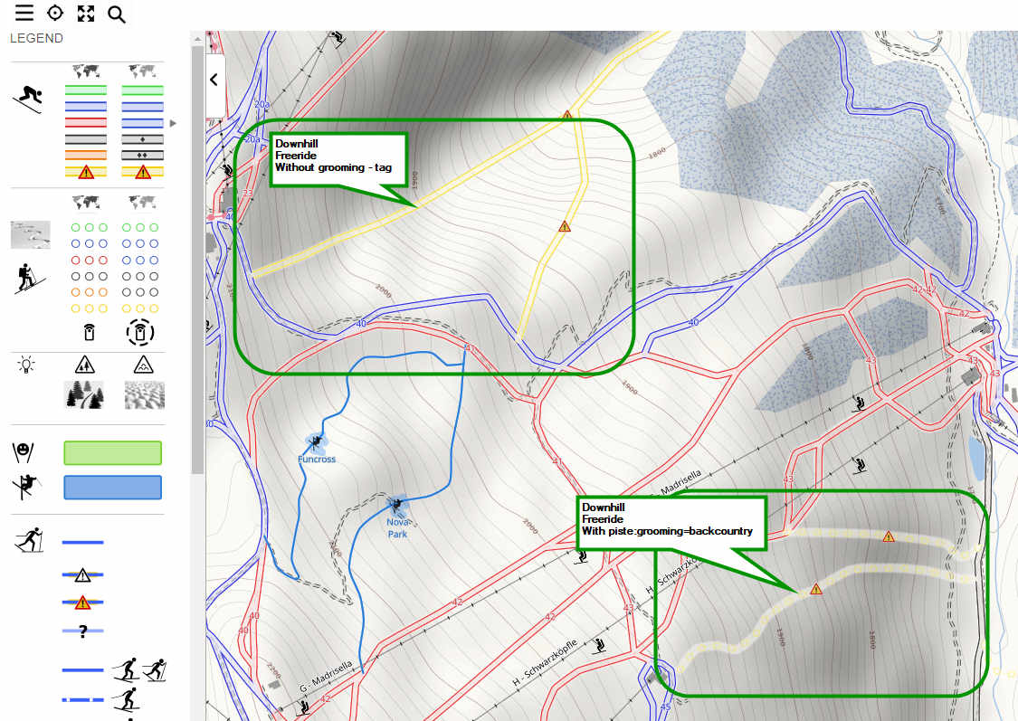
To your knowledge what’s the difference on the ground between the R22 and R45 pistes in the screenshot ?
Regardless of the confusion about the mapping, the rendering should be consistent, shouldn’t it?
If it was decided that piste:type=skitour is rendered with circles and =downhill with lines, then that should always be the case. And not suddenly change because of the (missing) grooming type. Downhill is still downhill.
I myself have not been to the St. Gallenkirch ski area, but according to the piste plan, they are official ski routes. With my understanding from our conversation, these should be mapped with “downhill”, “freeride” and “backcountry”. Only that the grooming on the R22 was not mapped at all.
Yes, so it seems that from the feedback on this thread I see here two things to means the same thing among different mappers:
A way tagged piste:type=downhill + piste:grooming=backcountry
A way tagged piste:type=downhill + piste:difficulty=freeride
Here is the cross-comparison:
piste:grooming value for pistes tagged piste:type=downhill + piste:difficulty=freeride
 count |    grooming
-------+-----------------
   591 |
   498 | backcountry
piste:difficulty values for piste:type=downhill + piste:grooming=backcountry
 count |  difficulty
-------+--------------
   856 | advanced
   676 | intermediate
   546 | expert
   498 | freeride
   218 | easy
   137 |
    21 | novice
    10 | extreme
    ... + noise
It also seems that most mappers take the pain to estimate a difficulty level for piste:type=downhill + piste:grooming=backcountry.
I like @ezekielf definitions near the top of the thread (post #6), they are neat and really look ‘by the book’.
Sadly, the key ‘patrolled’ is very seldom used, and ‘operator’ nearly non-existent
piste_type='downhill' and grooming='backcountry' => patrolled=yes 102 out of 2862
piste_type='downhill' and grooming='backcountry' => operator=something 3 out of 2862
These are probably the tags I’d like to take into account to distinguish ‘official’ runs from ‘the secret stash’ 
At least one mapper as done piste_type=‘downhill’ and grooming=‘backcountry’ and informal=‘yes’.
We thanks them for their honesty
This topic made me update the plan of a local resort. They stopped grooming quite a lot of their pistes, they even abandoned some completely. Not the least due to fights with landowners and also lack of snow cannons; but this is a different story. I consider this fine, opensnowmap indicating backcountry, a.k.a ungroomed pistes showing as dots. I do not think, they are patrolled. You try at your own risk, maybe a warning will be signposted, if there is no snow there. Still no idea how to differentiate these from downhills only available through skitour or from those, where powder-hunters deviate from the resort plan, except from being part in a site collection.
Update: One of the pistes in the resort collection is termed freeride - it is a locally well-known downhill, that has never been officially announced, it shows in yellow too, but has a triangle.
I took the liberty to update the wiki here and there from the feedback received here and on the French forum.
I don’t think I really changed anything, just added some precisions:
Difference between revisions of "Key:piste:difficulty" - OpenStreetMap Wiki (piste:difficulty freeride)
Difference between revisions of "Key:piste:grooming" - OpenStreetMap Wiki (mentionned ‘patrolled’ and ‘operator’ tag)
Difference between revisions of "Key:piste:grooming" - OpenStreetMap Wiki (explained piste:grooming=classic_for_skitour)
Difference between revisions of "Key:piste:grooming" - OpenStreetMap Wiki ( Precision: backcountry == un-groomed)
And finally, created :
https://wiki.openstreetmap.org/wiki/Tag:piste:type%3Dskitour
Tell me if something feels wrong or just improve the wiki 