‘Many’ being how many here? I think a few people agreeing to go against clear guidance, for still no logical reason I can see other than there is an access restriction - that is taken into account in any directions anyway regardless of highway status - on a section of road, is not good enough to constitute this mapping.
A few points to note:
- The UK guidance was not entirely aligned with the wider-OSM guidance which focuses on function and importance. Indeed, it’s even explicitly noted in the highways guidance:
Of course, every country can (and often does) have their own definitions for things, but being slightly more flexible and allowing tagging based on function seems sensible.
-
The UK documentation page was written in 2019 whilst the discussions being linked to are much older than that. So if usage was documented before the guidance was written, maybe it’s the guidance that needs tweaking.
-
It’s not entirely clear whether the UK documentation was intended to be so rigid or whether it should have meant “generally” we do it this way.
-
OSM is not bound by legal classifications and in fact in other cases it’s made very clear the on-the-ground situation takes precedence over legal sources.
It’s not just an access restriction though. It’s a fundamental change to the function of the highway. Take highway=primary, the definition is that it’s a major arterial road. A bus gate is simply not that, even if it retains the reference/classification that it once held when it was that.
Again from the wider OSM documentation:
I think, in general, there needs to be some flexibility for edge cases. This is the real-world. Only a Sith deals in absolutes.
5 Likes
I’ve been watching this thread with interest, as I’m mildly involved with a data consumer that doesn’t care about the road classification of the A420 in Oxford, but very much does care about mapping things that are on signs – and more importantly, about not rendering things that aren’t on signs.
I have also never been to Oxford and certainly am not familiar with its signage conventions, and am only just barely competent enough in understanding the UK system to render highway shields coloured icons for your routes numbered roads.
Key among the assumptions we make are that if there is a ref tag, then that route road number exists, manifestly, on the ground, in reality. When I look at a way chosen at random from that stretch, there is no indication whatsoever that the ref tag is unsigned.
If it is not signed, it should be tagged as an unsigned route road number using unsigned_ref instead of ref. That would allow renderers that directly render ref to not display it in places where it doesn’t exist. Now, I understand that there are a few different ways to tag unsigned ref values, but none of them are in use in this case.
So whatever you all decide, I hope the solution will inform data consumers that there is not, in fact, a numbered road which is signed at this location.
3 Likes
… and there’s quite a few similar ones that already use that tag or similar ones.
Edit: (shameless plug) an example of something that would honour unsigned_ref or similar is here.
This is probably the best solution presented so far. I think we should tag the A420 with either highway=primary and ref=A420 or highway=tertiary and unsigned_ref=A420 as you’ve pointed out. Both solutions are equally good in my opinion. The current tagging (tertiary and ref) is confusing and, from my point of view, led to this dispute in the first place. The UK does something similar with other types of road classification, e.g. C roads with highway_authority_ref tagging, so we could apply similar logic to this case with unsigned_ref per your comment. I’m interested to see what other people think of this perspective.
There’s also official_ref. It’s not really clear to me which of them to use when.
For example in Jersey, the roads have ref numbers and they occasionally appear on signs e.g. here, but they’re not really in use by the public as far as I know. I’ve never heard anyone say they’ve taken the A12 into town, the way someone in England might say they’re stuck in traffic on the M25. Should that be ref, unsigned_ref, highway_authority_ref, or official_ref?
Right now they’re all in the ref tag and it would take a lot of surveying to find out which ones actually appear on a sign and which ones aren’t signed at all.
On the topic of the thread, when part of Constitution Street in Leith (A900) was made tram only, this left a stub that’s only used for accessing a handful of residential streets and driveways, not as a through route, and another part that can be used as a through route but there’s no signage other than the name sign.
It seems like the legal classification just hasn’t caught up yet with the actual importance of the road for car drivers?
The tram-only bit is now service. The other bits… no one really seems to know how they should be tagged. Someone changed them to residential, then someone else changed them back to primary because apparently they’re still part of the A900 (which, if this is true, now can’t be driven end to end).
1 Like
Most M, A and B roads in the UK (highway=motorway, trunk, primary, secondary) have a signed number. Occasionally, some roads are missing their numbers on signage from adjoining roads. It’s very rare for such a road to be completely unsigned, though it’s more common in urban areas as has been observed here. Though most people don’t refer to roads by their numbers in everyday usage, people who are using navigation services like the ones offered on OSM should be able to see road numbers since it helps them navigate more important roads like the types mentioned above. It’s only situations like these that one could argue that a road number actually confuses people trying to navigate a busy urban road with traffic restrictions that prevent most users from using it if they’re driving a private motor vehicle.
Does it help anyone if a navigation service says “turn left on the A601” and the reference A601 only exists on paper, not any road sign?
If a navigation service shows the number, it ought to somehow make it clear that the number isn’t signed, so there’s no point in looking for it.
No, and that’s what I was talking about in my post above. Most M, A & B roads in the UK have a signed number, i.e. it’s unusual for them to have an unsigned number. Signed numbers are helpful for navigation purposes and it can be confusing when we provide the number for a completely unsigned route like the A601 in central Derby. Despite this, we should be reluctant to replace ref=* tags with unsigned_ref=* tags on major routes like the A601.
Something interesting of note is Ordnance Survey (a layer we use on OSM) provides the number for the A601 in central Derby. Local newspapers such as Live Derbyshire also use the A601 number in their writing. This also applies to the A420 in Oxford. Ordnance Survey also represents the A420 as a secondary A road unlike us. I think either method of mapping the A420 as I’ve outlined above are the best solutions to this dispute presented thus far (unsigned_ref=* being more likely, but I find mapping the A420 with primary=* and ref=* tags to be slightly preferable to the other option).
Local my posterior - the Reach journo writing that is also local to (reading down that list) Manchester, Surrey, Berkshire, Gloucestershire, Cheshire, Buckinghamshire, Lancashire… (and that’s just the first page).
No-one locally calls it the A601, and it’s not signed as that. It’s the “inner ring road” or (if you’re feeling extra descriptive) “Lara Croft Way / Mercian Way” etc.
I think that’s an excellent idea.
2 Likes
I recall someone saying it was signed in a previous argument (I’m not in a position to check).
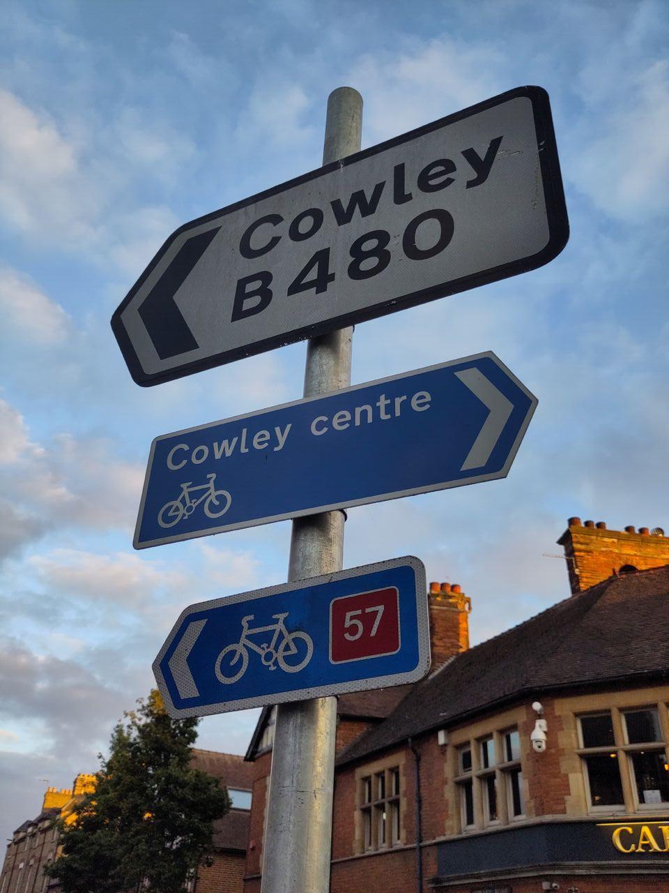
I can vouch for this in part from a recent (2024-09-03) photo survey, inspired by this thread. Between the railway bridge roadworks and the approaches to Headington (Green Road) Roundabout, there are no signs for the A420. I checked along the major approaches to this stretch’s junctions with the A4144, B480, B4150, and A4158 inside the ring road, and there are no signs directing traffic onto the A420 on any of those.
The Plain roundabout is one illustrative example. There, all the non-A420 routes are signposted, but not the A420, seemingly the lowest-numbered A road.
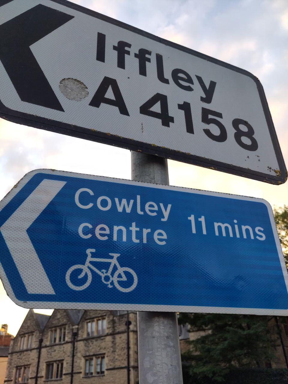
The first [EDIT: and only] sign I was able to find mentioning the A420 was this one, on the A40 London Road approach to Green Road / Headington / “Hamburger” Roundabout:

Even there, it’s shown as a minor exit, although not as minor as the Barton one. I was surprised it was even mentioned here, but Headington has a large university campus, and several large hospitals. You’d use the A420 London Road to get to it, and someone might be looking for that I guess.
From what I’ve seen it’s almost as if the city/county council don’t do anything to support use of the A420 as a route through the city. Funny, that.
(Not to mention, those long-term ongoing railway bridge roadworks slice everything in two at the moment. It’s not as if anything could use it as a through route.)
4 Likes
Don’t know if it’s been mentioned, but somebody added an A420 relation to OSM a few days back, in case anyone needs an overview of how sketchy and broken-up the designation is today. Wikipedia’s A420 page has more.
1 Like
This seems like wrong tagging. In past discussions, I’ve been specifically informed that numbered roads are not routes. Therefore, the route relations here should be removed as the fragments of A420 are not parts of a route but rather two separate numbered roads that happen to have the same number.
3 Likes
In past discussions, I’ve been specifically informed that numbered roads are not routes.
this is news to me, isn’t this what route=road is for?
https://wiki.openstreetmap.org/wiki/Tag%3Aroute%3Droad
1 Like
A close relative of “but my town is special” is “but my country is”, which isn’t always helpful in a worldwide map.
1 Like
No, that is for routes. A route travels along a sequence of one or more roads between longer distances. In the UK system, numbered roads are discontinuous. You can’t follow them across the country – they start and stop and often don’t even follow any meaningful alignment. Again, I am just re-describing the argument that has been made in the past about why route relations are wrong in the UK.
Route relations for numbered roads would also, as a side note, not even be useful for a shield renderer because the shields road number signs change with the underlying classification of the road. So you could have the same A-road be on a primary road in one area with one color, then be on a trunk road with totally different signs, and then also be on a motorway with totally different signs and different ref value.
So it’s not clear what a road route would be describing. It would be the same as creating a route relation in the United States that contains every street named “5th Avenue”.
I’m convinced the UK road numbering system was one of the causes of the Revolution.
3 Likes
I think the complication is that the UK signposts an unnumbered, color-coded system of primary and non-primary routes, which OSM generally indicates as highway=trunk versus primary if the wiki is to be believed. On top of that, the orthogonal system of road numbers is also signposted on the very same signs but is tied to the notion of a road with distinct endpoints, analogous to a road name. (On top of that, there’s an official “trunk” classification that OSM by and large ignores despite highway=trunk being named after it.)
By contrast, most countries either make no real distinction between roads and routes, or they number routes rather than roads, or they don’t signpost road numbers nearly as prominently. In some parts of the US, we even have all three situations simultaneously, but nothing like the UK.
I don’t know if the primary and non-primary routes are delineated well enough to form route relations out of them. They seem nebulous, like the American concept of a “truck route”: you can tell what is or isn’t part of a primary route, but you can’t necessarily tell one primary route from another. The road numbers are topologically more amenable to route relations, but are they really routes? Or would they be a different kind of relation, like street?
As I understand it, this stretch of road in Oxford is officially numbered and presumably is part of either a primary or non-primary route, but neither fact is signposted; the road is identified only by name. The good news is that there’s no shortage of keys for indicating an unsignposted road number – just pick one. But as for the highway=* classification, how would we even know if it’s part of a primary route? It seems like something of a parlour game.
In the absence of an on-the-ground reality, what do data consumers and end users need? The only renderers that would care are the ones that color-code roads based on their highway classification, most notably OSM Carto, whereas a renderer that prioritizes signs would be irrelevant as soon as the road number is moved to a different key. Most routers are unlikely to care much, either, because access restrictions and speed limits have a much bigger effect here than any heuristic based on highway classification, modulo some outdated assumptions.
I hope we aren’t spilling ink again because of OSM Carto. ![]()
Further reading, for those who prefer satire on a Saturday afternoon: