When on a road there is physical object (barrier, cemenent etc) we use to split the road to left and right side.
What should we prefer when there is no physical object but only paint on asphalt?
Among new highways, there is a sideway. Usually it is anonymous and as I found Greek users use to name all of them with plain name “Παραδρομος, sideway and etc”. Should we define the sideways with the number of the highway that is going among?
This information/definition will be useful when navigating at each area.
ika-chan
(Sharks with laser beams attached to their heads!)
2
Very interesting question you are trying to resolve.
I strongly support the standard of physical objects shaping the map ways.
In this case there is a median strip that - according to the highway code as well as physically- separates opposing traffic.
Therefore IMHO the right one is the most appropriate to be used.
The double line doesn’t alter the physical dimensions of the roadway including the width of the road, the track of the paths and the clearance in the middle,
nor does it create a no passing zone zone in between the opposing traffic.
The map needs to reflect road restrictions, obstructions and physical proportions repsectively
and if in doubt, we can take the example of other map projects.
ika-chan
(Sharks with laser beams attached to their heads!)
12
The marked clearance in the middle does not change the fact that it is still a single carriageway, and as I said, this is where lanes=, lanes:forward= and lanes:backward=* becomes useful.
For example, a two-way road with a clearance could be mapped with lanes=3, lanes:forward=1 and lanes:backward=1.
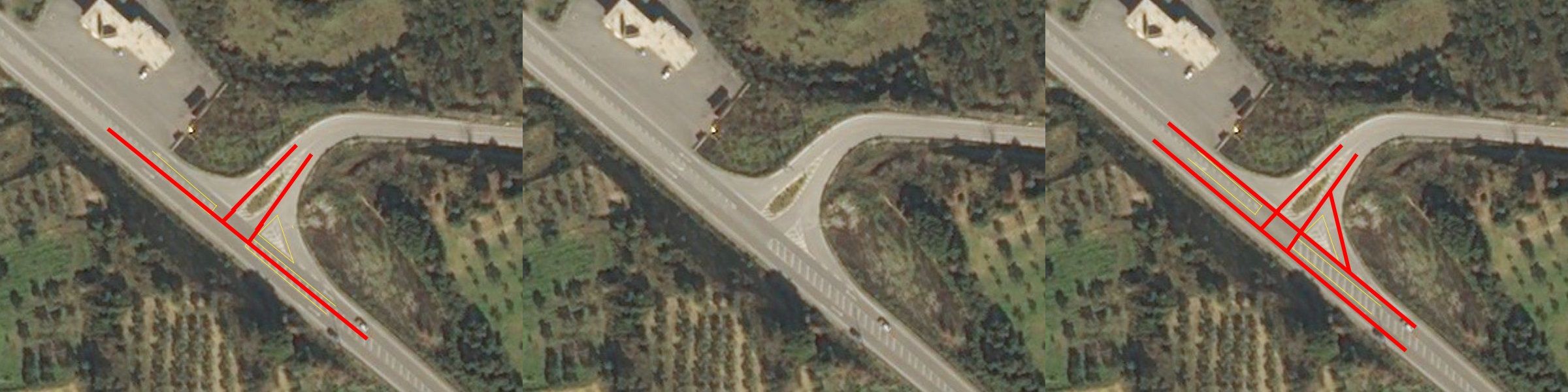
My question is not focusing on the details on the road, but on how should we create the road.
If I understood well, you suggest the 2 lines to be compacted in 1 with description on lanes, right?
@hariskar change background map to ESRI Beta and you will see better how should be the lines! @LeonCR as hariskar wrote, technically “mini_roundabout” should be right, but visually there will be a lack.
This is what happens to my example above and the suggestion of ika-chan!
What is more preferable, technically or visually right?
1 line with decriptions on lanes or 2 lanes with individual description? Technicity or Visuallity?
There should be basic suggestion on it by administrators.!
@Map-Finder, I prefer to use the Bing imagery, because as I see this is the most widely used worldwide. So I believe in Greece most editors use Bing. I use because if I use something else my edits will seem with offset to most users. (I don’t know which imagery is more correct)
Regarding what is better, visibly or technically right: I prefer what the wiki suggests, regardless if I don’t like it visibly. Eg here https://www.openstreetmap.org/edit?editor=id#map=22/40.93420/24.38527 I had a roundabout, but I changed it to a mini_roundabout, because the wiki says so for this case. I don’t like it visibly, but since it clearly is a mini_roundabout according to the wiki, I chose to tag it this way.
@Map-Finder
Both approaches are correct and acceptable in OSM. But in general OSM prefers technicality over visuality.
@hariskar
There is no imagery more correct than the other. All imageries have an offset, and that is because of the Mercator projection. Offset differs from place to place, and depends mostly on latitude.
So, always adjust offset before any edits, by aligning imagery with what is already mapped or with gpx tracks.
PS I prefer Bing too because has good enough resolution, in most areas.
It would be better if all Greek editors could agree eg with a poll to use the same imagery. Finding on the map whole villages, cities or roads with a different offset than the rest of the area is very annoying…