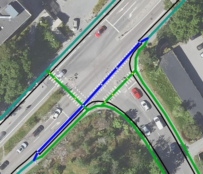
It is currently mapped as a dedicated cycleway and footpath which continues all the way through the intersection.
What actually happens, however, is that the cycleway goes down from the pavement, onto the road and then goes up onto the pavement again, after the intersection. (Can be sort-of seen on the orthophotos).
I was wondering if there was any better way to actually map what is happening. I thought of creating a way from the pavement onto the main road and adding all the appropriate lane tags, but I am wondering whether this might create routing issues (i.e. routing software perceiving it as a slight left turn where there is none).
The best way to map this is to keep the geometries as they are, but to add separation=no to the short section which is shared with the roadway at the intersection.
Creating false diagonal geometries to join the road centreline, and then leave it again, is misleading both in cartographical and routing terms. As a cyclist riding the route, you are continuing straight on, in the direction implied by the current (straight) cycleway. You are not merging at one angle then leaving at another.
Adding separation=no conveys the maximum information (i.e. both the correct geometry and the correct physical infrastructure), in contrast to false geometries which convey the infrastructure but not the geometry. The latter approach has been used extensively in London and the results are, unfortunately, very poor.
(This is sometimes described as the “centreline problem” and has been written about elsewhere.)
Curiously, that is why I find the “centreline problem” so difficult but also quite appealing: I see this in my area, e.g. a cycle-lane ends and merges with the psv-lane that comes out of nothing but serves a bus-stop. I cycle straight through. With lane mapping this turns into a conundrum, with centreline mapping, it needs splitting the highway. Which is more of a problem?
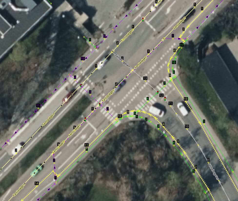
3 mappers, 3 opinions: I would recommend separating the ways, but running the bike path geometry along its actual course instead of connecting it to the road center line. If crossings, kerbs etc. are mapped, you have to divide the ways anyway, otherwise you can’t map them accurately (see graphic).
I don’t see the point in connecting the cycleway to the center line here. The dogma “no separate line if the cycleway is on the carriageway” does not lead us any further here and, in my opinion, does not apply here, as the cycleway generally does not run on the carriageway, but only for a short section near the junction. So why connecting to the centerline here? This brings many disadvantages (incorrect geometry, complexity, etc.) but loses many advantages (positional accuracy, specific tags for kerbs, crossings, etc.).
Regarding separation: I think using a highway=path for a shared foot/bicycle way is more common, isn’t it? And similar to how we use other keys such as surface or width in such a case, you can of course also use separation. In this case, near the junction, this would mean e.g. cycleway:width=1.2, cycleway:surface=asphalt, cycleway:separation=no… (It would be more accurate to use cycleway:separation:left=no, because there is no physical separation only to the left (to motorized traffic). To the right, to the sidewalk, there is probably a curb (cycleway:separation:right=kerb).
Thanks for the replies everyone, it seems there is no consensus on how to approach such situations. In Stockholm situations like this are very common. See for example Götgatan or Sveavägen, where cycleways climb on curbs, go back into the road, turn into lanes with or without segregation.
I asked this question mainly from a cyclist’s point of view because usually there is not such detail in the map to discern whether a cycleway mapped as a separate way is segregated from other traffic traffic.
I applied the separation approach in Götgatan and I thought it was relatively straightforward. Although the syntax is somewhat clunky at times, it’s relatively straightforward and can cover all kinds of bike lanes, irrespectively of whether they are mapped on the main way or in a separate one.
Creating a way to join it to the main road also allows mapping the main road lanes in detail and would also be convey what is happening, i.e. the lane is joining the main road. However, I don’t like this approach, as I think it would be better for someone navigating using the map to see a straight way, than to see a left turn.
This is a common layout of an intersection. If you want to map it in more detail, I would exactly do what you suggest:
I would add two short new (, vertical diagonal) ways, one from the “sidewalk” highway=cycleway to the main highway and “after” the intersection one from the main highway to the “sidewalk” highway=cycleway with following tags:
cycleway=link gives the detail that the way’s primary purpose is a link for routing
placement=transition is the tag to say that the way’s placement is not in the middle of the road/way but somehow diagonal and that angles on both sides are off or virtual. It’s a pity, thought, but many router software do not use placement=* atm.
The sidewalks around the intersections need to be downgraded to highway=footway, footway=sidewalk
The main highway needs cycleway tags as proposed. Mainly cycleway=lane though there are more tags for further details.
If the main highways are tagged in detail with *:lanes tags these tags’ values need to be adjusted and cycleway:lanes[:forward/backward]=* and bicycle:lanes[:forward/backward]=* need to be added. (Forward resp. backward depend on the way’s direction)